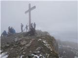
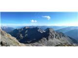
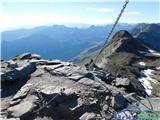
 | Ljubelj - Hochstuhl/Stol (upper way)
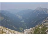
At 2236 m, Stol is the highest peak in the Karavanke Mountains. From the summit, which has a registration box and a stamp, we have a beautiful vi...
4 h 50 min |
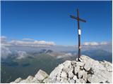
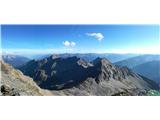
| Johannsenruhe - Hochstuhl/Stol (via Klagenfurter Hütte)
At 2236 m, Stol is the highest peak in the Karavanke Mountains. From the summit, which has a registration box and a stamp, we have a beautiful vi...
3 h 45 min |
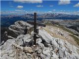
| Ljubelj - Hochstuhl/Stol (via Vatelca or Skleda)
At 2236 m, Stol is the highest peak in the Karavanke Mountains. From the summit, which has a registration box and a stamp, we have a beautiful vi...
5 h |
 | Collina - Cima Ombladet (path 141)
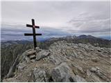
Cima Ombladet is a 2255-metre-high mountain in Carnic Alps, east of Forni Avoltri. From the top of the hill, where there is a small cross, there ...
3 h 20 min |
 | Planina Blato - Mala Zelnarica (via Štapce)
Mala Zelnarica is a 2310 m high peak located between the Triglav Lakes Valley and the Za Kopica Valley. The summit, which has a registration box ...
5 h 15 min |
 | Parkplatz Tappenkarweg - Weißgrubenkopf (Parkplatz Tappenkarweg - Weißgrubenkopf)
...
3 h 30 min |
 | Aljažev dom v Vratih - Križ (via bivak na Rušju)
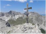
Križ is a 2140 m high mountain located north-east of the Kriški Podi. From the top, where there is a registration box with a stamp, you have a be...
4 h 30 min |
 | Untere Wolayeralm - Rauchkofel
To the north of Monte Coglians, the highest peak of Carnic Alps, is the 2460 m high Rauchkofel. From the top, where a cross and a signing box sta...
3 h 45 min |
 | Tri studničky - Kriváň
Mount Kriváň is the first dominant peak of the High Tauern, seen from the west, and belongs to the Tatra National Park. It rises above the Liptov...
4 h |
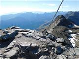
 | Sella Nevea - Prestreljenik (on ski track)
Prestreljenik is a 2499 m high mountain located in the heart of the Kanin Mountains. From the top, where the Aljaž Tower-shaped registration box ...
3 h 30 min |
 | Aljažev dom v Vratih - Stenar (via Sovatna)
Stenar is a 2501 m high peak rising steeply above the Vrata valley. From the spacious summit, where there is a registration box and a stamp, we h...
5 h 15 min |
 | Klammbrückl - Weittalspitze
Weittalspitze is a 2,539-metre-high peak in the Lienz Dolomites. The summit is located south of the mountain pasture Kerschbaumeralm. From the su...
3 h 30 min |
 | Sant'Uberto - Bivacco Baccon Barborka
The Bivacco Baccon Barborka is a smaller bivouac with four beds. The bivouac is located next to the Furcia Rossa III peak, where you will see a l...
4 h 35 min |
| Rifugio Pederü - Bivacco Baccon Barborka
The Bivacco Baccon Barborka is a smaller bivouac with four beds. The bivouac is located next to the Furcia Rossa III peak, where you will see a l...
4 h 10 min |
 | Maria Waldrast - Serles (western approach from Maria Waldrast)
Serles is one of the most recognisable, admired and visited hills around Innsbruck. Together with the Hafelekar (or Nordkette Ridge) and the Pats...
3 h 30 min |
 | San Martino - Cima della Rosetta
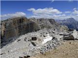
Cima della Rosetta is a 2,743-metre-high peak rising above San Martino. From the summit on which the cross stands, you have a beautiful view over...
3 h 40 min |
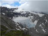 | Parkplatz Innerfragant - Goldbergtauernkopf (via Fraganter Scharte)
Goldbergtauernkopf is a lesser-known peak between the Fraganter Scharte and Niedere Scharte couloirs above the Mölltaler Glacier. From the 2775 m...
6 h |
 | Rifugio Pederü - Muntejela de Sennes
Muntejela de Sennes (Monte Sella di Sennes) is a 2,787-metre-high peak in the Fanes Sennes Prags Natural Park. The summit is located west of the ...
3 h 30 min |
| Rifugio Ra Stua - Muntejela de Sennes
Muntejela de Sennes (Monte Sella di Sennes) is a 2,787-metre-high peak in the Fanes Sennes Prags Natural Park. The summit is located west of the ...
3 h 30 min |
 | Parking below Jamnigalm - Hinterer Geißlkopf
Hinterer Geißlkopf (the name has many variations, such as Geiselkopf / Geisslkopf / Geiselspitze) is a 2888 meter-high mountain in a Goldberg mou...
4 h 40 min |
 | Sportgastein - Hinterer Geißlkopf (via Hagener Hütte)
Hinterer Geißlkopf (the name has many variations, such as Geiselkopf / Geisslkopf / Geiselspitze) is a 2888 meter-high mountain in a Goldberg mou...
5 h 15 min |
 | Lech da Sompunt - Piz de Puez / Puezspitz (path 11)
Piz de Puez (East Peak) is a 2913 m high peak in the Puez mountain group. It is reached by a marked trail and is relatively easy to reach. The We...
6 h |
| Lech da Sompunt - Piz de Puez / Puezspitz (path 15)
Piz de Puez (East Peak) is a 2913 m high peak in the Puez mountain group. It is reached by a marked trail and is relatively easy to reach. The We...
6 h |
| Colfosco - Piz de Puez / Puezspitz
Piz de Puez (East Peak) is a 2913 m high peak in the Puez mountain group. It is reached by a marked trail and is relatively easy to reach. The We...
4 h 45 min |
 | Parking below Jamnigalm - Vordere Geislspitze / Vorderer Gesselkopf
Vordere Geislspitze is a mountain in Hohe Tauern in Austria in Goldberge mountain group. The name of the mountain has many variations, i.e. Hohe ...
4 h 30 min |
 | Sportgastein - Vordere Geislspitze / Vorderer Gesselkopf (via Hagener Hütte)
Vordere Geislspitze is a mountain in Hohe Tauern in Austria in Goldberge mountain group. The name of the mountain has many variations, i.e. Hohe ...
5 h 15 min |