Starting point: Passo di Giau (2233 m)
| Lat/Lon: | 46,4825°N 12,0538°E |
| |
Time of walking: 1 h 55 min
Difficulty: very difficult marked way
Altitude difference: 416 m
Altitude difference po putu: 600 m
Map: Tabacco 03 1:25.000
Recommended equipment (summer): helmet, self belay set
Recommended equipment (winter): helmet, self belay set, ice axe, crampons
Views: 10.101
 | 1 person likes this post |
Access to the starting point:
First, drive to Cortina d'Ampezzo (you can get here via Border crossing Rateče or Predel to Trbiž / Tarvisio and then take the motorway towards Udine to the Tolmezzo exit. From Tolmezzo, follow the road towards Ampezzo and the Passo della Mauria mountain pass. The road then descends and leads to a crossroads where you turn left (possibly right) towards Cortina d'Ampezzo. At all subsequent junctions, follow the signs for Cortina d'Ampezzo. Or from the Primorska side, take the motorway towards Trieste. Continue on the Italian motorway towards Padua, but only as far as the motorway junction where you continue towards Veneto and Belluno. Near Belluno, the motorway ends and we continue towards Cortina d'Ampezzo at the next junctions and then follow the signs for the Passo di Falzarego Alpine pass. We then follow this ascending road to a junction at about 1400m. At the crossroads, turn left towards the Passo di Giau and the Marmolada. Park in the large parking lot on the aforementioned Alpine pass.
Path description:
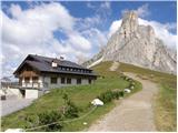
From the pass, continue along a wide path past the Rifugio Passo Giau hut. After a short climb along a wide path, you reach a crossroads where the 443 trail branches off to the right. We continue up the wide path, then the path becomes narrower and turns slightly left to the west side of Mount Ragusela. Here the path starts to descend and crosses the scree to the north. Later, the path starts to climb up a rather steep and also slightly crumbly slope, which then leads to grassy slopes. From the grassy slopes, you soon join the wide path from the Rifugio Fedare (2000m), followed by a short climb up to the Averau hut.
From the hut, continue straight past the hut along the mountain road. After a few metres, the sign "Ferrata Averau" will direct you uphill to the left. The path then first crosses the scree on the east side of the mountain and soon turns left to enter the climbing part of the route. At the start of the climbing route, climb steeply along a ropeway over a steep wall, and then reach a fork in the route. The left-hand, slightly easier route climbs vertically on scree through a vent. The right-hand path also climbs almost vertically, but there are no steel cables. It should be noted that the left-hand path is often wet and the snow also stays a little longer. After a short steep section, the two paths rejoin and there is a steel cable crossing to the right. The climbing part of the route is quickly over and you soon reach the less steep summit slopes of the mountain. In the last part of the route, the trail is no longer difficult and soon you reach a very scenic summit.

Pictures:
 1
1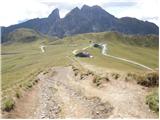 2
2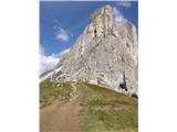 3
3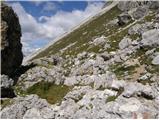 4
4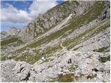 5
5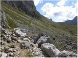 6
6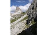 7
7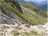 8
8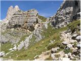 9
9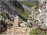 10
10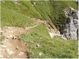 11
11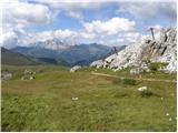 12
12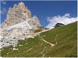 13
13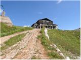 14
14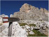 15
15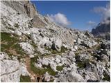 16
16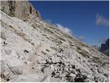 17
17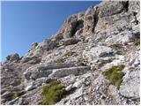 18
18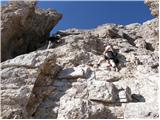 19
19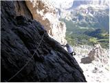 20
20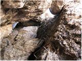 21
21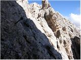 22
22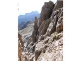 23
23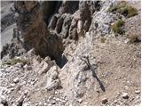 24
24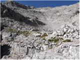 25
25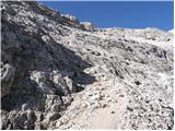 26
26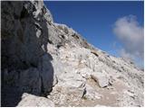 27
27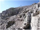 28
28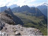 29
29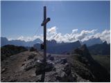 30
30
Discussion about the trail Passo di Giau - Averau
|
| StyLa16. 08. 2016 |
V nedeljo, 14.8.2016, sva s partnerjem opravila to turico. Kljub temu da veliko hodiva sva bolj začetnika v feratanju (do sedaj v Slo Gradiška Tura in Mala Mojstrovka), tako da sva jo izbrala ravno zato, ker se omenja kot ena lažjih v Dolomitih. Sama imam nekaj težav z izpostalvjenostjo in zračnostjo poti, tako da sem se tega pred samo turo najbolj bala.
Do vstopa v plezalni del je pot lep sprehod od Passa di Giau mimo Rifugia Averau. Sam plezalni del pa je kratek, nič kaj izpostavljen ali zračen. Zgolj na dveh mestih se mi je tehnično zdel bolj zahteven (čisto na začetku in pa v sredini-ta del se da obiti levo po kaminu če ni preveč gužve). Na teh dveh mestih so bolj redki in majhni oprimki, tako da si je treba tudi z rokami kar pomagati, sicer pa kar prijeten oz. nič posebnega. Po koncu plezalnega dela sledi samo še meliščna, dokaj strma a neizpostavljena pot do vrha, s katerega so res krasni pogledi na okoliške vrhove.
Vrniti se je potem treba po isti poti, a se mi je ta navzdol zdela nekoliko lažja kot navzgor, tudi na težjih mestih.
Od vsega se mi je torej zdelo najbolj neprijetno in nevarno to, da je bila v plezalnem delu velika gneča, saj česa podobnega nisva še nikoli doživela. Res je, da sva bila tam v nedeljo pred praznikom in ne najbolj zgodaj, a žal smo na sam vstop v steno morali v koloni čakati cca. 20-30min, in tudi v steni smo se potem morali čakati, tako za navzgor kot tudi navzdol.
Ne glede na to pa je turica res luštna in prijetna in verjamem, da se da tudi gneči z boljšo izbiro dneva in res zgodnjim štartom v veliki meri izogniti.
|
|
|