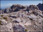
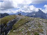
 | Pri Mlinču - Mangart (italijanska pot)
Mangart (also Mangrt, both spellings are grammatically correct) is a mountain that receives a very high number of visitors in summer. Access to t...
4 h 45 min |
 | Aljažev dom v Vratih - Dolkova špica (western way)
Dolkova špica is a 2591 m high mountain located between Stenar and Škrlatica. From the summit, where the registration box is located, you can enj...
5 h 15 min |
 | Suhadolnik - Grintovec (via Streha)
Grintovec is the highest peak in the Kamnik and Savinja Alps. It is located above the valley of Kamniška Bistrica, Suhi dol and above the valley ...
4 h 45 min |
 | Aljažev dom v Vratih - Triglavski dom na Kredarici (via Prag)
Triglavski dom na Kredarici is Slovenia's highest mountain hut. It is open all year round but only on an emergency basis out of season. From the ...
5 h |
 | The Kot Valley - Triglavski dom na Kredarici
Triglavski dom na Kredarici is Slovenia's highest mountain hut. It is open all year round but only on an emergency basis out of season. From the ...
5 h |
| Uskovnica (Lom) - Triglavski dom na Kredarici (via Planina Spodnji Tosc)
Triglavski dom na Kredarici is Slovenia's highest mountain hut. It is open all year round but only on an emergency basis out of season. From the ...
5 h 35 min |
| Uskovnica (Razpotje) - Triglavski dom na Kredarici (via planina Spodnji Tosc)
Triglavski dom na Kredarici is Slovenia's highest mountain hut. It is open all year round but only on an emergency basis out of season. From the ...
5 h 30 min |
 | The Kot Valley - Rjavina (ridge way)
Rjavina is located between two Alpine valleys. The two valleys are Kot and Krma. From the summit, which has a registration book, there is a very ...
6 h |
 | V Koncu - Skuta (via Kokrsko sedlo)
Skuta is a 2532 m high mountain located in the heart of the Kamink Savinja Alps. From the top, where there is a registration box and a stamp, we ...
5 h 30 min |
 | Gozdec - Prestreljenik (via dom Petra Skalarja)
Prestreljenik is a 2499 m high mountain located in the heart of the Kanin Mountains. From the top, where the Aljaž Tower-shaped registration box ...
5 h 45 min |
| B station - Prestreljenik (via Krnica)
Prestreljenik is a 2499 m high mountain located in the heart of the Kanin Mountains. From the top, where the Aljaž Tower-shaped registration box ...
4 h 25 min |
| Sella Nevea - Prestreljenik (via Rifugio Gilberti)
Prestreljenik is a 2499 m high mountain located in the heart of the Kanin Mountains. From the top, where the Aljaž Tower-shaped registration box ...
4 h 15 min |
| Sella Nevea - Prestreljenik (via 636)
Prestreljenik is a 2499 m high mountain located in the heart of the Kanin Mountains. From the top, where the Aljaž Tower-shaped registration box ...
3 h 45 min |
 | Pišnica - Špik (via Kačji graben)
Špik is a 2,472 m high mountain located in the heart of the Martuljek Mountains. From the top, which is clearly visible from the road leading thr...
4 h 45 min |
| Ruski križ - Špik (via Kačji graben)
Špik is a 2,472 m high mountain located in the heart of the Martuljek Mountains. From the top, which is clearly visible from the road leading thr...
4 h 50 min |
 | Aljažev dom v Vratih - Begunjski vrh (via Prag)
Begunjski vrh is a 2461 m high mountain located in the heart of the highest mountains in the Julian Alps. From the top, which has a registration ...
5 h |
 | Bodenbauer - Hochstuhl/Stol
At 2236 m, Stol is the highest peak in the Karavanke Mountains. From the summit, which has a registration box and a stamp, we have a beautiful vi...
4 h 30 min |
 | Bodenbauer - Vertatscha/Vrtača
Vertatscha is a 2181 m high peak located to the east of Stol. From the top of the peak, on which stands a large wedge, we have a beautiful view o...
4 h 45 min |
 | Jermanca - Planjava (via Kamniško sedlo)
Planjava is a small mountain range to the east of Kamnik saddle. It has two peaks, one eastern and one western. There is a marked trail to the ea...
4 h 30 min |
| Koča pod slapom Rinka - Planjava
Planjava is a small mountain range to the east of Kamnik saddle. It has two peaks, one eastern and one western. There is a marked trail to the ea...
4 h 45 min |
 | Na Razpotju - Planjava
Planjava is a small mountain range to the east of Kamnik saddle. It has two peaks, one eastern and one western. There is a marked trail to the ea...
5 h |
| Dom Planincev v Logarski dolini - Planjava
Planjava is a small mountain range to the east of Kamnik saddle. It has two peaks, one eastern and one western. There is a marked trail to the ea...
4 h 55 min |
 | Laško - Storžič (via Kališče)
Storžič is a 2132 m high mountain located in the western part of the Kamink Savinja Alps. From the top with a cross there are beautiful views of ...
3 h 30 min |
 | Laško - Storžič (via Sveti Lovrenc and over Bašeljski preval)
Storžič is a 2132 m high mountain located in the western part of the Kamink Savinja Alps. From the top with a cross there are beautiful views of ...
4 h 30 min |
 | Tržiški graben - Storžič (via Javorniški preval)
Storžič is a 2132 m high mountain located in the western part of the Kamink Savinja Alps. From the top with a cross there are beautiful views of ...
3 h 40 min |
| MHE Zabukovec - Storžič (via Bašeljski preval)
Storžič is a 2132 m high mountain located in the western part of the Kamink Savinja Alps. From the top with a cross there are beautiful views of ...
4 h |
 | Jermanca - Brana (via Kamniško sedlo)
Brana is a mountain above Kamnik saddle. The view from the spacious summit, which has a registration box and a small cross, is very beautiful. Pl...
3 h 45 min |
| Koča pod slapom Rinka - Brana
Brana is a mountain above Kamnik saddle. The view from the spacious summit, which has a registration box and a small cross, is very beautiful. Pl...
3 h 45 min |
 | Belca - Mittagskogel/Kepa
Kepa, also Jepa, or Mittagskogel in German, is a scenic mountain in the western Karawanks, located on the border ridge between Slovenia and Austr...
4 h 15 min |
 | Erjavčev rovt - Mittagskogel/Kepa
Kepa, also Jepa, or Mittagskogel in German, is a scenic mountain in the western Karawanks, located on the border ridge between Slovenia and Austr...
3 h 50 min |
| Ravne - Mittagskogel/Kepa
Kepa, also Jepa, or Mittagskogel in German, is a scenic mountain in the western Karawanks, located on the border ridge between Slovenia and Austr...
4 h 15 min |
 | Čemernica / Tschemernitzen - Mittagskogel/Kepa
Kepa, also Jepa, or Mittagskogel in German, is a scenic mountain in the western Karawanks, located on the border ridge between Slovenia and Austr...
5 h 5 min |
 | Suhadolnik - Kalška gora
Kalška gora is located between Kalški greben and Kokrsko sedlo. From the top, which is covered with grass, there is a beautiful view towards the ...
3 h 30 min |
 | Na Razpotju - Ojstrica (via Škarje)
Ojstrica, named after its sharp shape, rises steeply above the Korošica River, the Logar Valley and Robanov Kot. From the top, where the registra...
4 h 15 min |
| Dom Planincev v Logarski dolini - Ojstrica (via Škarje)
Ojstrica, named after its sharp shape, rises steeply above the Korošica River, the Logar Valley and Robanov Kot. From the top, where the registra...
4 h 10 min |
 | Tolminske Ravne - Tolminski Kuk (via planina Razor)
Tolminski Kuk is the highest peak of the Lower Bohinj Mountains. The summit, which has a registration box, offers a very nice view. From the top ...
4 h 45 min |
 | The Kot Valley - Cmir
The mountain is located between two Alpine valleys between Vrata and the lesser-known Za Cmirom valley. From the top you can enjoy a beautiful vi...
6 h |
 | Aljažev dom v Vratih - Križ (via Sovatna)
Križ is a 2140 m high mountain located north-east of the Kriški Podi. From the top, where there is a registration box with a stamp, you have a be...
5 h |
 | Podnar / Bodenbauer - Prešernova koča na Stolu
Prešernova koča na Stolu, is located just a few metres below the summit of the 2198 m high Mali Stol. From the hut or the nearby Mali Stol, we ha...
4 h 25 min |
 | Aljažev dom v Vratih - Visoka Vrbanova špica (via Prag)
Visoka Vrbanova špica, is located at the extreme south-western part of the ridge rising above the Kot and Vrata valleys, and higher up between th...
4 h 50 min |
 | Planina Blato - Veliko Špičje (via Štapce)
Veliko Špičje is the highest peak in the ridge from Travnik to Zasavska hut. From the top there is a very nice view over the plateaus of Komna, t...
5 h 45 min |
 | Tolminske Ravne - Vogel (steep path and over Globoko)
When you hear the name Vogel, many people first think of the Vogel ski resort, which is located near the peak of the same name. From the north si...
3 h 45 min |
 | Aljažev dom v Vratih - Bovški Gamsovec (via Luknja)
Bovški Gamsovec is a 2392m high mountain in the immediate vicinity of Triglava. From the top, you can enjoy a magnificent view of Triglav and its...
4 h 30 min |
| Aljažev dom v Vratih - Bovški Gamsovec (via Sovatna)
Bovški Gamsovec is a 2392m high mountain in the immediate vicinity of Triglava. From the top, you can enjoy a magnificent view of Triglav and its...
4 h 45 min |
 | Valbruna - Jof di Miezegnot/Poldašnja špica (via Planina Ravne)
Jof di Miezegnot is the easternmost of the two-thousanders in the Naborjeta Mountains (Monti di Malborgheto) group. From the top of the mountain,...
3 h 45 min |
| Valbruna - Jof di Miezegnot/Poldašnja špica (via Planina Strehica)
Jof di Miezegnot is the easternmost of the two-thousanders in the Naborjeta Mountains (Monti di Malborgheto) group. From the top of the mountain,...
4 h |
 | Malborghetto - Jof di Miezegnot/Poldašnja špica
Jof di Miezegnot is the easternmost of the two-thousanders in the Naborjeta Mountains (Monti di Malborgheto) group. From the top of the mountain,...
4 h |
 | Malborghetto - Cima Alta (Due Pizzi) (path 605)
The two peaks (Due Pizzi) form two peaks in the Naborjeta group, namely Cima Alta (2046m) and Cima Vildiver (2008m). On both peaks there is a cro...
4 h 25 min |
 | Ovčja vas / Valbruna - Kamniti lovec / Cima del Cacciatore
Kamniti lovec is a popular excursion point above Trbiz. It is well visited due to its short access, which is shortened by a cable car to Višarje....
4 h |
 | Žabnice / Camporosso in Valcanale - Kamniti lovec / Cima del Cacciatore
Kamniti lovec is a popular excursion point above Trbiz. It is well visited due to its short access, which is shortened by a cable car to Višarje....
3 h 30 min |
 | Ravenska Kočna - Velika (Koroška) Baba (via Jenkova planina)
Velika is a 2127 m high mountain on the border ridge above the Ravenská Kočna valley on the Slovenian side and above the Bela valley (Belska Kočn...
3 h 30 min |
 | Sella Nevea - Velika Črnelska špica (on ski track)
Velika Črnelska špica is located in the Kanin Mountains on the border between Itali and Slovenia. From the top, you can enjoy a very nice view of...
4 h 30 min |
| Sella Nevea - Velika Črnelska špica (via 636)
Velika Črnelska špica is located in the Kanin Mountains on the border between Itali and Slovenia. From the top, you can enjoy a very nice view of...
4 h 45 min |
 | Tolminske Ravne - Vrh nad Škrbino (on steep and direct path)
Vrh nad Škrbino is the easternmost two-thousandth peak in the ridge of the Lower Bohinj Mountains. From the top there is a very nice view of the ...
3 h 30 min |
 | Goldberg - Torkofel
Torkofel is the highest peak of the Jauken lookout ridge, which stretches north of the Ziljska valley. From the top with a cross there is a beaut...
3 h 45 min |
 | Na Razpotju - Krofička (marked way)
Krofička, or Grofička according to some records, is a peak located northeast of Ojstrica. From the summit, which descends steeply towards the Log...
3 h 40 min |
| Dom Planincev v Logarski dolini - Krofička (marked path)
Krofička, or Grofička according to some records, is a peak located northeast of Ojstrica. From the summit, which descends steeply towards the Log...
3 h 35 min |
 | Reklanska dolina - Sart / Žrd
Žrd, or Monte Sart in Italian, is a scenic mountain located on the north-western ridge of the Kanin mountain range. From the summit, which has a ...
5 h 15 min |
 | Sella Nevea - Viš/Jof Fuart
Viš is a 2666m high peak in the western Julian Alps. From the top, where the statue of St Mary and the cross stand, you can enjoy a beautiful vie...
5 h |
| Cave del Mole - Viš/Jof Fuart
Viš is a 2666m high peak in the western Julian Alps. From the top, where the statue of St Mary and the cross stand, you can enjoy a beautiful vie...
4 h 30 min |
 | Aljažev dom v Vratih - Pihavec (via Sovatna)
Pihavec is a vast and scenic peak located to the south of the Kriški Podovi. From the summit, which has a registration box and a stamp, there is ...
5 h |
 | Cave del Mole - Koštrunove špice (via Forcella Lavinal dell Orso)
Koštrunove špice is a 2502 m high peak located south-west of Viš (2666 m). The summit offers a beautiful view over most of the western Julian Alp...
4 h |
| Cave del Mole - Koštrunove špice (via Forcella Mose)
Koštrunove špice is a 2502 m high peak located south-west of Viš (2666 m). The summit offers a beautiful view over most of the western Julian Alp...
4 h |
| Sella Nevea - Koštrunove špice (via Forcella Lavinal dell Orso)
Koštrunove špice is a 2502 m high peak located south-west of Viš (2666 m). The summit offers a beautiful view over most of the western Julian Alp...
4 h 30 min |
 | Tolminske Ravne - Zeleni vrh (via planina Razor)
Zeleni vrh is a 2052 m high mountain located east of the highest peak of the Lower Bohinj Mountains. The grassy peak, which descends precipitousl...
4 h 20 min |
 | Parking Alpspitzbahn - Bernadeinkopf (via Osterfelderkopf)
Bernadeinkopf is a 2143 m high peak in the Wetterstein mountain group. From the summit on which the cross stands, you have a very nice view of th...
5 h 30 min |
 | Weißenbach - Spitzegel / Negal (via Bodenalm)
Spitzegel or. Negal (in Slovene) is a 2119 m high mountain in Gailtal Alps in Austria.The narrow ridge is a logical continuation of Dobrač / Dobr...
4 h 30 min |
 | Val Aupa - Sernio (via normale)
Sernio (it. Monte Sernio / in Furlani language: Serenât or. Crede di Seregnò) is a 2187 m high mountain in Carnic Alps in Italy between the easte...
4 h 30 min |
 | Cima Sappada - Creton di Tul
Creton di Tul is a 2288 meter high mountain in a mountain group Pesarina Dolomites in the Carnic Alps in Italy, south of a city of Sappada and ju...
3 h 30 min |
 | Cima Sappada - Creta Forata
Creta Forata is a 2462 meter high mountain in a mountain group of the Pesarina Dolomites in the Carnic Alps in Italy, south of a city of Sappada....
4 h |
 | Gschnitz - Kalkwand (zahodni pristop iz Gschnitza preko Pinnisjocha)
Kalkwand is a large mountain in the eastern part of the Habicht group of the central Stubai Alps. Thanks to its attractive views, the low difficu...
3 h 45 min |