V Koncu - Kranjska Rinka (via Žmavčarji)
Starting point: V Koncu (900 m)
| Lat/Lon: | 46,342°N 14,5682°E |
| |
Name of path: via Žmavčarji
Time of walking: 4 h 35 min
Difficulty: difficult unmarked way
Altitude difference: 1553 m
Altitude difference po putu: 1553 m
Map: Kamniške in Savinjske Alpe 1:50.000
Recommended equipment (summer): helmet
Recommended equipment (winter): helmet, ice axe, crampons
Views: 24.235
 | 3 people like this post |
Access to the starting point:
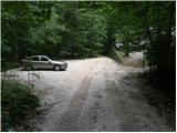
Drive into Kamnik and follow the road towards the Kamnik Bistrica valley. From your home in Kamniška Bistrica, continue driving along the forest road, which takes you higher up to a crossroads where you continue straight ahead (right Jermanca, starting point for Kamniško sedlo). The road then takes you past Žagana peči to the parking lot at the lower station of the cargo cableway to Kokrsko sedlo.
After the new traffic sign, driving from the Kamniški Bistrica hut to the V Koncu parking lot is forbidden, which extends the journey by almost an hour.
Path description:
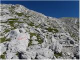
From the parking lot at the cargo cableway, continue along the deteriorating road, which turns into cart track after 10 minutes of walking. Cart track splits into two parts, and we take the right one (the left cart track is lost, or leads towards Gams' Hide), which turns slightly further to the right at a small boulder covered with moss (a large rock). It is at this point that cart track is abandoned and you continue straight on the initially less visible path, which later climbs steeply in the keys. The steep and, especially in wet conditions, slippery path leads over steep slopes, which in some places are protected by a steel cable. The steep path, which also crosses some ravines, leads us higher up to a less steep slope. After a good hour's walk, the path leads us out of the forest, where it starts to climb steeply again. The path initially leads us over grassy slopes surrounded by sparse forest, and then, with the help of a few fixed safety gear, it takes us a step higher. The path then moves on to a rough slope, which makes the ascent a little more difficult, and then turns left onto a steep grassy slope rising above vast scree fields. At the top of this grassy section, turn slightly right and the path moves from the grass to the high mountain area of high-lying plateau below Skuta. Continue along the cairns path and in a few minutes you will reach the pleasant bivouac below Skuta.
From the bivouac, continue along the poorly visible and still unmarked path along the unmarked ridge, which leads us after a 15-minute walk from the bivouac to the marked path Kamniško sedlo - Kokrsko sedlo. Here we continue to the right and after a few minutes we arrive at a crossroads where we continue sharp left in the direction of Skute and Rink. Only a little further on we come to the next crossroads, where we continue right up towards Rink (straight Skuta). The way forward climbs steeply for a short time, and then leads us to an undistinguished ridge along and along which we then climb. Just before the marked path reaches the Mala Rinka peak, it turns slightly to the left and descends slightly to the notch between the Mala and the Štajerská Rinka. On the other side of the stubble, the marked path starts climbing again and after a few minutes of further walking leads to a marked crossroads, where we continue straight in the direction of Kranjska Rinka (to the right Koroška Rinka). The trail then crosses the slopes of Koroška Rinka and then turns slightly to the left, where it climbs steeply. There is a short, very steep climb, and then the path leads to the main ridge, which is followed in a few steps to the top of the Kranjska Rinka. In Konec - bivouac under Skuto 3:00, bivouac under Skuto - Kranjska Rinka 1:35.

Pictures:
 1
1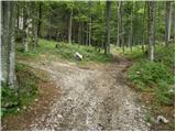 2
2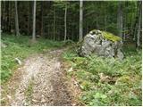 3
3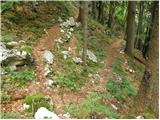 4
4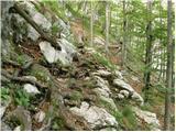 5
5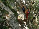 6
6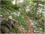 7
7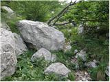 8
8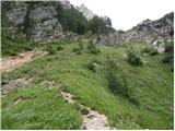 9
9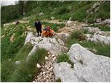 10
10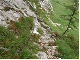 11
11 12
12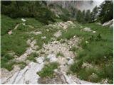 13
13 14
14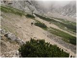 15
15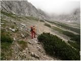 16
16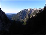 17
17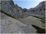 18
18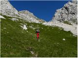 19
19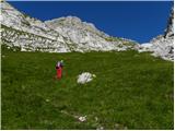 20
20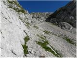 21
21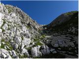 22
22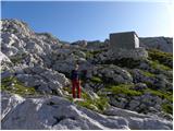 23
23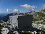 24
24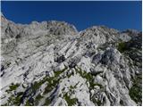 25
25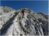 26
26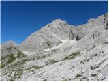 27
27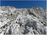 28
28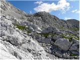 29
29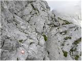 30
30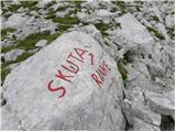 31
3132
 33
33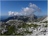 34
34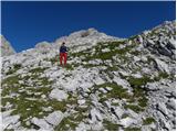 35
35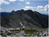 36
36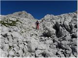 37
37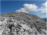 38
38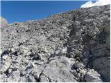 39
39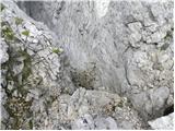 40
40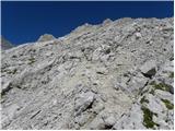 41
41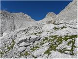 42
42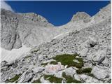 43
43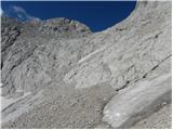 44
44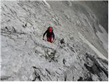 45
45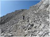 46
46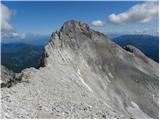 47
47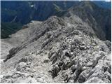 48
48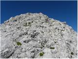 49
49 50
50
Discussion about the trail V Koncu - Kranjska Rinka (via Žmavčarji)
|
| Guest5. 02. 2008 |
Kakšen je zimski vzpon skozi Žmavcarje v času, ko ni nevarnosti snežnih plazov? Hvala za odgovor.
lp. Franci
|
|
|
|
| Guest5. 02. 2008 |
Čet Žmavčarje je zaradi precejšnje strmine nevarnost zdrsa. Cepin in dereze sta na tej turi obvezna. V okolici bivaka pod Skuto je večje število brezen in razpok, ki so skrita pod snegom. Potrebna je velika previdnost. lp ) 
|
|
|
|
| pohodnik3815. 08. 2012 |
V nedeljo prehodil tole pot,ki je brez posebnosti.Ob vzponu gosta megla zgoraj na podih pa sonček.Po osvojenih Rinkah nadaljeval čez Tursko goro in Kotliče na Kamniško sedlo.Od koder sestop v dolino na izhodišče. NEKAJ VIDEO UTRINKOV Lp!
|
|
|
|
| pohodnik3822. 08. 2012 |
Pa še uspel nekaj napisat in naložit nekaj slik SLIKE
|
|
|
|
| ggorenc25. 03. 2016 |
Ali se do spodnje postaje zicnice se da peljati z avtomobilom ali rabis terenca? Nisem bil ze nekaj let v tem koncu.
|
|
|
|
| andi225. 03. 2016 |
Z avtomobilom. Oziroma (kot se za tako lepe kotičke kot so V Koncu in Žmavčarji splača) 20 min hoje od Doma v Bistrici peš srečno!
|
|
|
|
| redbull25. 03. 2016 |
20min hoje od doma pa do Konca? Bi pa rad videl Pred leti je od Doma bilo potrebno teci na tekmu ba Grintovec in si moral za 14-15minut kar vrhunsko teci. Zdaj je podobno le da je start cez vodo.
|
|
|
|
| lino25. 03. 2016 |
Redbull, če je športnik tvojega kova, je mogoče.
|
|
|
|
| ggorenc3. 04. 2016 |
Hvala, sem bil taksen sportnik 15 let nazaj sedaj pa ne vec, leta prinesejo svoje zato me zanima kaksna je cesta.
|
|
|
|
| ggorenc9. 11. 2017 |
Bil nekaj vikendov nazaj na skuti. Se vedno strmo kot vcasih in kamenje leti cez zmavcarje kot bi ljudje zgoraj tekmovali kdo ga bo vec spustil. Dajte paziti zgoraj prosim. Pet metrov od mene je letela pol meterska skala. Zgoraj se mi je nekdo sicer opravicil ampak to bolj malo pomaga.
|
|
|
|
| seinfeld16. 09. 2019 |
Včeraj v čudovitem dnevu po tej poti na Rinke. Pot je enostavno sledljiva, na nekaj mestih pridejo v pomoč roke, se pa ves čas strmo vzpenja. Nekaj težav je z markacijami od bivaka do vznožja Rink, vendar v dobri vidljivosti ni problema. Za Rinke sva potrebovala dobre 4ure zmerne hoje.
Vračala sva se preko slemena, do bivaka pod Grintavcem, čez Kokrsko sedlo do izhodišča. Naporna, okrog 14km dolga pot, dobrih 1900 višinskih metrov, v devetih urah.
|
|
|