V Koncu - Turska gora (via Žmavčarji)
Starting point: V Koncu (900 m)
| Lat/Lon: | 46,342°N 14,5682°E |
| |
Name of path: via Žmavčarji
Time of walking: 4 h 15 min
Difficulty: difficult unmarked way
Altitude difference: 1351 m
Altitude difference po putu: 1351 m
Map: Kamniške in Savinjske Alpe 1:50.000
Recommended equipment (summer):
Recommended equipment (winter): ice axe, crampons
Views: 33.860
 | 3 people like this post |
Access to the starting point:
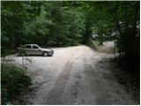
Drive into Kamnik and follow the road towards the Kamnik Bistrica valley. From your home in Kamniška Bistrica, continue driving along the forest road, which takes you higher up to a crossroads where you continue straight ahead (right Jermanca, starting point for Kamniško sedlo). The road then takes you past Žagana peči to the parking lot at the lower station of the cargo cableway to Kokrsko sedlo.
After the new traffic sign, driving from the Kamniški Bistrica hut to the V Koncu parking lot is forbidden, which extends the journey by almost an hour.
Path description:
From the parking lot at the cargo cableway, continue along the deteriorating road, which turns into cart track after 10 minutes of walking. Cart track splits into two parts, and we take the right one (the left cart track is lost, or leads towards Gams' Hide), which turns slightly further to the right at a small boulder covered with moss (a large rock). It is at this point that cart track is abandoned and you continue straight on the initially less visible path, which later climbs steeply in the keys. The steep and, especially in wet conditions, slippery path leads over steep slopes, which in some places are protected by a steel cable. The steep path, which also crosses some ravines, leads us higher up to a less steep slope. After a good hour's walk, the path leads us out of the forest, where it starts to climb steeply again. The path initially leads us over grassy slopes surrounded by sparse forest, and then, with the help of a few fixed safety gear, it takes us a step higher. The path then moves on to a rough slope, which makes the ascent a little more difficult, and then turns left onto a steep grassy slope rising above vast scree fields. At the top of this grassy section, turn slightly right and the path transitions from grass to the high mountain area of high-lying plateau below Skuta. Continue along the cairns path and in a few minutes you will reach the pleasant bivouac below Skuta.
From the bivouac, continue along the poorly visible and still unmarked path along the unmarked ridge, which leads us after a 15-minute walk from the bivouac to the marked path Kamniško sedlo - Kokrsko sedlo. Here we continue to the right and after a few minutes we arrive at the crossroads of the trail, where we continue along the lower right trail in the direction of Turska gora (left Rinke). The trail then begins to descend and after a few minutes leads us to the top of Turski žleb. Continue straight on (left down Okrešelj) along the increasingly scenic path, which leads us with the help of a few wedges to the top ridge Turska gora which we then follow to the top. Walking on the ridge on land does not present any major problems, but in the snow there is a high risk of slipping on the top ridge.
In Konec - bivouac under Skuta 3:00, bivouac under Skuta - Turska gora 1:15.

Pictures:
 1
1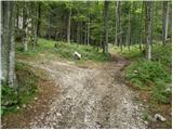 2
2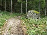 3
3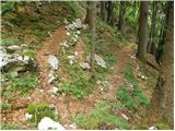 4
4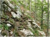 5
5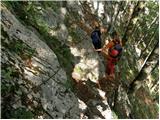 6
6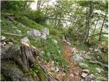 7
7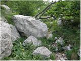 8
8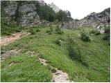 9
9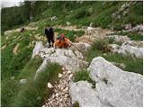 10
10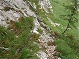 11
11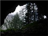 12
12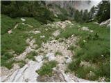 13
13 14
14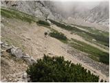 15
15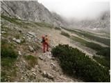 16
16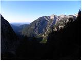 17
17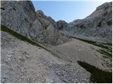 18
18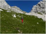 19
19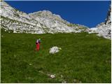 20
20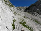 21
21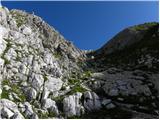 22
22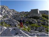 23
23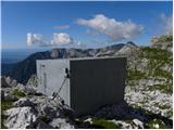 24
24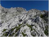 25
25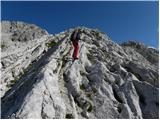 26
26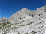 27
27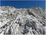 28
28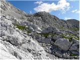 29
29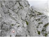 30
30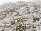 31
31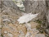 32
32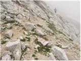 33
33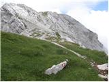 34
34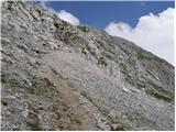 35
35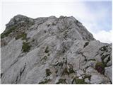 36
36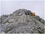 37
37
Discussion about the trail V Koncu - Turska gora (via Žmavčarji)
|
| Guest16. 05. 2007 |
Po slikah sodeč pot ni zahtevna.Vendar pa kolikor vem nobena pot na Tursko goro ni prav lahka.Na turski gori še nisem bil, ali je na kakšnih delih pot zelo izpostavljena?
Miha.
|
|
|
|
| Guest16. 05. 2007 |
Greben od Turskega žleba do vrha je na nekaterih mestih rahlo izpostavljen a mislim, da ne povzroča težav, seveda v kopnem.
|
|
|
|
| Guest24. 10. 2007 |
Zelo prijetna tura. Čez Žmavcarje v spodnjem delu v mokrem nevarnost zdrsa . Proti Kamniškemu sedlu najtežji del čez Sod brez dna, kjer nam čez navpično okno pomaga zajla. Del čez Kotliče je izpostavljen, vendar povsod zavarovan z jeklenico.
|
|
|
|
| Guest29. 10. 2007 |
Zahodno od bivaka pribljiLlno 10m pa je kar veliko brezno nevarno, ker ni okli nobene oznake, previdno!!
|
|
|
|
| Guest8. 02. 2008 |
Ob poti bi lahko opisovalo narovne in kulturne znamenitosti.
|
|
|
|
| urbancek27. 06. 2011 |
Živjo! Zanima me, kako je zdaj s cesto od doma v Kamniški bistrici do spodnje postaje žičnice v koncu (lani se je nekaj govorilo, da je zaprta za promet??!) No, v primeru, da je odprta, me zanima še stanje cestišča  Hvala za odgovor!
|
|
|
|
| Janez Seliškar27. 06. 2011 |
Pri Domu v Kamniški Bistrici stoji znak, ki prepoveduje vožnjo naprej od Doma.
|
|
|
|
| urbancek27. 06. 2011 |
In to pomeni, da se V konec ne bo več vozilo z avtomobili??? 
|
|
|
|
| gorskarozica3. 08. 2012 |
Zelo lepa pot čez Žmavčarje, lepo oskrbovana, čestitam! Dolžina poti je prilagojena za zelo hitre planince. 
|
|
|
|
| Barentoter4. 12. 2015 |
Pozdravljeni, je kdo hodil te dni čez Žmavčarje na Tursko goro ali Dolgi hrbet? Zanima me če je še kaj snega na poti? Hvala!
|
|
|
|
| redbull4. 12. 2015 |
Če te zanima kako je s snegom? Največ ga je v tisti strmini pod Bivakom pod Skuto(Žmavčarji). Drugje ga je malo, zaplate noz. bolj kopna poledenela podlaga.
srečno
|
|
|
|
| smatjaz19. 05. 2016 |
Ali je bil kdo zadnje čase po tej poti na gori? Zimska oprema bo v nahrbtniku, le začetnika bomo imeli s seboj pa se raje izognemo senžiščom če se le da....... 
|
|
|
|
| Macesna19. 05. 2016 |
Smatjaz, poglej pod rubriko Razmere, tema Bivak pod Skuto, zadnje slike so od 17. 5.
|
|
|
|
| smatjaz19. 05. 2016 |
Hvala, sem že dobil odgovor, ga še ni za telovadit tam gori tako da bomo počakali na kopne razmere.....
|
|
|
|
| čotke29. 06. 2016 |
Super tura, razmere ugodne
|
|
|
|
| trdi30. 05. 2018 |
Tale čas 2:45 do bivaka je bolj za hitre planince...
|
|
|
|
| Tadej30. 05. 2018 |
Hvala za opozorilo, sem popravil čas do bivaka na 3 ure.
|
|
|
|
| oselica25. 06. 2018 |
Ali je ta pot še vedno nemarkirana in katera je najmanj nevarna za na Tursko goro. Hvala
|
|
|
|
| HMatjaž25. 06. 2018 |
Pot čez Žmavcarje je nemarkirana.
|
|
|
|
| Hribolazec8121. 09. 2018 |
Pozdrav, v nedeljo imam plan na Tursko goro, šel pa bi tudi na Kranjsko rinko, kakšen nasvet? Hvala Gregor
|
|
|
|
| Kanjanez21. 07. 2019 |
A kdo kej ve v kakšnem stanju je trenutno pot od Bistrice naprej do Konca? Je ful razrita od neviht...?
|
|
|
|
| mornar21. 07. 2019 |
Bil včeraj pot je zelo slaba.
|
|
|