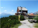
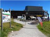
 | Dom v Dragi - Begunjščica (via Roblekov dom)
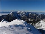
Begunjščica is a mountain range in Karawanks east of Stol. The highest peak is Veliki vrh, which at over 2000m offers a beautiful view of central...
4 h 20 min |
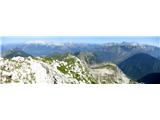
 | Matizovec - Veliki vrh (Košuta)
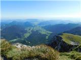
Veliki vrh, with a height of 2088 m, is the westernmost two-thousander in the longest Slovenian ridge - the Košuta. From the summit, where there ...
3 h 20 min |
| Globoka dolina - Veliki vrh (Košuta)
Veliki vrh, with a height of 2088 m, is the westernmost two-thousander in the longest Slovenian ridge - the Košuta. From the summit, where there ...
3 h |
 | Podljubelj - Veliki vrh (Košuta) (via Matizovec)
Veliki vrh, with a height of 2088 m, is the westernmost two-thousander in the longest Slovenian ridge - the Košuta. From the summit, where there ...
4 h 15 min |
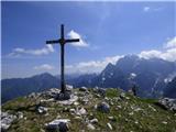
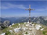
 | Povlje - Storžič (through southwest groove)
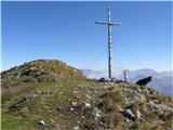
Storžič is a 2132 m high mountain located in the western part of the Kamink Savinja Alps. From the top with a cross there are beautiful views of ...
4 h |
 | Ravne - Črna prst (via Orožnova koča)
On the northern slope of the Črna prst summit head, you can see the black soil from which the mountain takes its name. Črna prst is known for its...
3 h 5 min |
 | Kocenpohar - Črna prst
On the northern slope of the Črna prst summit head, you can see the black soil from which the mountain takes its name. Črna prst is known for its...
2 h 45 min |
| Ravne - Črna prst (via planina za Črno goro)
On the northern slope of the Črna prst summit head, you can see the black soil from which the mountain takes its name. Črna prst is known for its...
3 h 25 min |
 | Pod Luknjo - Črna prst
On the northern slope of the Črna prst summit head, you can see the black soil from which the mountain takes its name. Črna prst is known for its...
2 h 30 min |
 | Kal - Črna prst
On the northern slope of the Črna prst summit head, you can see the black soil from which the mountain takes its name. Črna prst is known for its...
2 h 30 min |
 | Gozd - Tolsti vrh (easier path over Kriška gora)
Tolsti vrh, located to the west of Storžič, is also the highest peak of the Kriška Gora, a mountain range rising steeply above the central Gorenj...
2 h 30 min |
 | Zalog - Tolsti vrh
Tolsti vrh, located to the west of Storžič, is also the highest peak of the Kriška Gora, a mountain range rising steeply above the central Gorenj...
3 h |
 | Tržič - Tolsti vrh
Tolsti vrh, located to the west of Storžič, is also the highest peak of the Kriška Gora, a mountain range rising steeply above the central Gorenj...
3 h 15 min |
 | Gozd - Tolsti vrh (steep path over Kriška gora)
Tolsti vrh, located to the west of Storžič, is also the highest peak of the Kriška Gora, a mountain range rising steeply above the central Gorenj...
2 h 30 min |
| Povlje - Tolsti vrh
Tolsti vrh, located to the west of Storžič, is also the highest peak of the Kriška Gora, a mountain range rising steeply above the central Gorenj...
2 h 45 min |
 | Leskova dolina - Snežnik
Snežnik or Veliki Snežnik is the highest peak in the near and far surroundings with a height of 1796 m. It offers a beautiful view over most of S...
3 h 15 min |
 | Mašun - Snežnik
Snežnik or Veliki Snežnik is the highest peak in the near and far surroundings with a height of 1796 m. It offers a beautiful view over most of S...
4 h |
 | Brezje pri Tržiču - Dobrča (on path Po robu and via Lešanska planina)
Dobrča is a 1634 m high mountain located between Begunje and Tržič. From the top, where the registration box with the stamp is located, we can se...
2 h 35 min |
 | Brezje pri Tržiču - Dobrča (via koča na Dobrči)
Dobrča is a 1634 m high mountain located between Begunje and Tržič. From the top, where the registration box with the stamp is located, we can se...
3 h |
| Brezje pri Tržiču - Dobrča (po robu)
Dobrča is a 1634 m high mountain located between Begunje and Tržič. From the top, where the registration box with the stamp is located, we can se...
2 h 30 min |
 | Zadnja vas - Dobrča
Dobrča is a 1634 m high mountain located between Begunje and Tržič. From the top, where the registration box with the stamp is located, we can se...
3 h |
| Hudi Graben - Dobrča (via Koča na Dobrči)
Dobrča is a 1634 m high mountain located between Begunje and Tržič. From the top, where the registration box with the stamp is located, we can se...
3 h |
| Slatna - Dobrča
Dobrča is a 1634 m high mountain located between Begunje and Tržič. From the top, where the registration box with the stamp is located, we can se...
3 h |
 | Begunje (Preska) - Dobrča
Dobrča is a 1634 m high mountain located between Begunje and Tržič. From the top, where the registration box with the stamp is located, we can se...
3 h |
 | Bistrica pri Tržiču - Dobrča
Dobrča is a 1634 m high mountain located between Begunje and Tržič. From the top, where the registration box with the stamp is located, we can se...
2 h 55 min |
| Brezje pri Tržiču - Dobrča (by road)
Dobrča is a 1634 m high mountain located between Begunje and Tržič. From the top, where the registration box with the stamp is located, we can se...
2 h 45 min |
 | Radušnik - Velika Raduha
At 2062 m, Velika Raduha is the highest peak of Raduha, a mountain range rising steeply to the east of Robanov Kot. From the summit, which has a ...
3 h 10 min |
 | Planina Kosmačeve Rastke - Velika Raduha
At 2062 m, Velika Raduha is the highest peak of Raduha, a mountain range rising steeply to the east of Robanov Kot. From the summit, which has a ...
2 h 55 min |
| Tolminske Ravne - Tolminski Kuk (via Planina Kal)
Tolminski Kuk is the highest peak of the Lower Bohinj Mountains. The summit, which has a registration box, offers a very nice view. From the top ...
4 h |
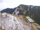
 | Zadnjica - Pogačnikov dom na Kriških podih
The hut is located on a panoramic hill in the Kriški Podi above Trenta. The hut, which is open in the summer season, also has a large winter room...
4 h |
 | Zadnjica - Zasavska koča na Prehodavcih
Zasavska koča na Prehodavcih is located on a scenic peak above the Triglav Lakes Valley. The hut, which is open in the summer season, offers a be...
4 h 15 min |
 | Volaka - Blegoš
Blegoš is a 1562 m high mountain located between Selška and Poljane Sora. From the grassy summit, on which there is a stamp and a registration bo...
2 h 35 min |
 | Dom Trilobit - Barentaler Kotschna/Struška
Barentaler Kotschna is a small mountain range located between Stolo or Belščica and Golica. From Veliki vrh, as the highest peak of the mountain ...
3 h |
| Rute (Zavrh) / Bärental - Barentaler Kotschna/Struška (via Bärensattel)
Barentaler Kotschna is a small mountain range located between Stolo or Belščica and Golica. From Veliki vrh, as the highest peak of the mountain ...
2 h 45 min |
 | Petrovo Brdo - Možic (via Vrh Bače)
Možic is a 1602 m high peak located west of Soriška mountain pasture. It is at the highest point of the peak that there is an old military bunker...
2 h 30 min |
| Petrovo Brdo - Možic (via Lajnar)
Možic is a 1602 m high peak located west of Soriška mountain pasture. It is at the highest point of the peak that there is an old military bunker...
2 h 30 min |
 | Petrovo Brdo - Porezen
Porezen is a 1630 m high mountain located between Davča and Baška Grapa. From the top, where a large NOB monument stands, we have a beautiful vie...
2 h 30 min |
 | Poče - Porezen (steep path)
Porezen is a 1630 m high mountain located between Davča and Baška Grapa. From the top, where a large NOB monument stands, we have a beautiful vie...
2 h 30 min |
| Poče - Porezen (gentle path)
Porezen is a 1630 m high mountain located between Davča and Baška Grapa. From the top, where a large NOB monument stands, we have a beautiful vie...
2 h 45 min |
 | Jesenica - Porezen
Porezen is a 1630 m high mountain located between Davča and Baška Grapa. From the top, where a large NOB monument stands, we have a beautiful vie...
2 h 55 min |
 | Jesenica - Porezen (via Dom na Poreznu)
Porezen is a 1630 m high mountain located between Davča and Baška Grapa. From the top, where a large NOB monument stands, we have a beautiful vie...
3 h |
| Preval Vrh Ravni - Porezen
Porezen is a 1630 m high mountain located between Davča and Baška Grapa. From the top, where a large NOB monument stands, we have a beautiful vie...
2 h 30 min |
| Preval Vrh Ravni - Porezen (via Dom na Poreznu)
Porezen is a 1630 m high mountain located between Davča and Baška Grapa. From the top, where a large NOB monument stands, we have a beautiful vie...
2 h 35 min |
 | Poče - Porezen (via Labinjske lehe)
Porezen is a 1630 m high mountain located between Davča and Baška Grapa. From the top, where a large NOB monument stands, we have a beautiful vie...
3 h 15 min |
| Poče - Porezen (winter way)
Porezen is a 1630 m high mountain located between Davča and Baška Grapa. From the top, where a large NOB monument stands, we have a beautiful vie...
3 h 25 min |
 | Mače - Srednji vrh (via Kozjek and Dolga njiva)
Srednji vrh is an 1853 m high mountain located to the east of Storžič. From the top, where there is a bench, a registration box and a stamp, we h...
3 h 30 min |
| Mače - Srednji vrh (Mačenska pot and via Cjanovca)
Srednji vrh is an 1853 m high mountain located to the east of Storžič. From the top, where there is a bench, a registration box and a stamp, we h...
3 h 50 min |
| Mače - Srednji vrh (Mačenska pot and via Dolga njiva)
Srednji vrh is an 1853 m high mountain located to the east of Storžič. From the top, where there is a bench, a registration box and a stamp, we h...
3 h 35 min |
| Mače - Srednji vrh (via Kozjek and Cjanovca)
Srednji vrh is an 1853 m high mountain located to the east of Storžič. From the top, where there is a bench, a registration box and a stamp, we h...
4 h |
 | Planina pod Golico - Kahlkogel/Golica (via Suha saddle)
Kahlkogel is an unvegetated peak located north of Jesenice. From the top, which has a registration box, there is a beautiful view of the western ...
3 h |
 | Dom Pristava in Javorniški Rovt - Kahlkogel/Golica (via mountain hut)
Kahlkogel is an unvegetated peak located north of Jesenice. From the top, which has a registration box, there is a beautiful view of the western ...
2 h 45 min |
 | Stara Fužina - Pršivec (direct way)
Lookout Mountain is located above Lake Bohinj. The view is extensive on all sides. Triglav and the mountains around it can be seen, and on the ot...
3 h 45 min |
 | Mače - Bašeljski vrh
Bašeljski vrh is a 1744 m high mountain located between Mali Grintovec and Storžič. From the top, where there is a bench and a registration box w...
3 h 15 min |
 | Bašelj - Bašeljski vrh (via hospital Košuta)
Bašeljski vrh is a 1744 m high mountain located between Mali Grintovec and Storžič. From the top, where there is a bench and a registration box w...
3 h 25 min |
| Bašelj - Bašeljski vrh
Bašeljski vrh is a 1744 m high mountain located between Mali Grintovec and Storžič. From the top, where there is a bench and a registration box w...
3 h 15 min |
| Mače - Bašeljski vrh (via Kozjek)
Bašeljski vrh is a 1744 m high mountain located between Mali Grintovec and Storžič. From the top, where there is a bench and a registration box w...
3 h 30 min |
 | MHE Zabukovec - Bašeljski vrh
Bašeljski vrh is a 1744 m high mountain located between Mali Grintovec and Storžič. From the top, where there is a bench and a registration box w...
3 h 5 min |
 | Dovje - Frauenkogel/Dovška Baba
Frauenkogel is an 1891 m high peak located on the border ridge between Slovenia and Austria. The summit, which has a registration box and a stamp...
3 h |
 | Ljubelj - Srednji vrh (above Završnica) (via source of Završnica)
Srednji vrh is a scenic and dwarf pines mountain located between Stol, Vertatscha and Begunjščica. From the summit, which descends precipitously ...
2 h 40 min |
 | Ljubelj - Srednji vrh (above Završnica) (on a slope of Vrtača)
Srednji vrh is a scenic and dwarf pines mountain located between Stol, Vertatscha and Begunjščica. From the summit, which descends precipitously ...
2 h 40 min |
 | Javorje - Rodica (marked way)
The mountain is located above Bohinj in the Lower Bohinj Mountains. From the top there is a beautiful view of Julian Alps and Škofjeloško and the...
2 h 45 min |
| Rutarski gozd - Rodica
The mountain is located above Bohinj in the Lower Bohinj Mountains. From the top there is a beautiful view of Julian Alps and Škofjeloško and the...
2 h 30 min |
 | Grant - Rodica
The mountain is located above Bohinj in the Lower Bohinj Mountains. From the top there is a beautiful view of Julian Alps and Škofjeloško and the...
3 h 30 min |
| Stržišče - Rodica
The mountain is located above Bohinj in the Lower Bohinj Mountains. From the top there is a beautiful view of Julian Alps and Škofjeloško and the...
4 h 15 min |
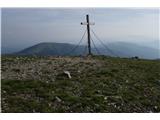
 | Markova raven - Vrh Korena (marked way)
Vrh Korena is located between Zvoh and Kalški greben near the Krvavški ski slopes. From the top there is a beautiful view towards the highest pea...
3 h 15 min |
 | Markova raven - Kompotela (marked way)
Kompotela is a peak near Mokrica and the summit of Koren. The grass and dwarf pines covered peak has a beautiful view towards Grintovec, Skuta, B...
3 h |
 | Markova raven - Mokrica (marked way)
Mokrica is a scenic peak to the east of Kompotele. On the top, which is partly covered with dwarf pines, there is a registration book....
3 h 30 min |
 | Mojstrana - Sleme
The mountain is located between Mojstrana and Kukova Spica. The top is grassy and has a very nice view towards Kukova Spica. From the top there i...
4 h 15 min |
 | Grahovše - Bela peč (via Boršt)
The mountain, which is known mainly by climbers, is located north of Storžič on the slopes of Konjščice. From the top there is a beautiful view o...
2 h 30 min |
 | Grahovše - Bela peč (via rot)
The mountain, which is known mainly by climbers, is located north of Storžič on the slopes of Konjščice. From the top there is a beautiful view o...
2 h 30 min |
 | Grahovše - Bela peč (via Rekar)
The mountain, which is known mainly by climbers, is located north of Storžič on the slopes of Konjščice. From the top there is a beautiful view o...
2 h 30 min |
 | Planina pod Golico - Rosenkogel/Hruški vrh
Rosenkogel is a 1776 m high mountain located between Frauenkogel and the slightly less known Klek. From the top, where there is a small chapel de...
2 h 30 min |
 | Rosenbach - Rosenkogel/Hruški vrh
Rosenkogel is a 1776 m high mountain located between Frauenkogel and the slightly less known Klek. From the top, where there is a small chapel de...
3 h 50 min |
 | Rosenbach - Rosenkogel/Hruški vrh (via Koprivnjak)
Rosenkogel is a 1776 m high mountain located between Frauenkogel and the slightly less known Klek. From the top, where there is a small chapel de...
4 h |
 | Ravenska Kočna - Goli vrh (austrian way)
Goli vrh is a 1787 m high mountain located between the valleys of Ravena and Belska Koča. From the uncultivated summit, on which there is a regis...
2 h 30 min |
| Velacher Kotschna/Belska Kočna - Goli vrh
Goli vrh is a 1787 m high mountain located between the valleys of Ravena and Belska Koča. From the uncultivated summit, on which there is a regis...
2 h 45 min |
 | Baumgartnerhof - Kresišče
Kresišče is a 1839 m high peak located in the main ridge of Karawanks, more precisely between Kepa and Trupe's Non. From the summit, on which sta...
3 h |
 | Planina Kuhinja - Batognica (via jezero v Lužnici)
Batognica is a 2164 m high mountain, which was affected by the Mine War during World War I. Remnants of the mine war between the Italians and the...
4 h |
 | Zavrzelno - Čukla
Čukla is located above the Bovec basin on the Rombon escarpment. From the top of the pyramid (a monument commemorating the capture of Čukla) ther...
3 h |
 | Koča pri izviru Soče - Vršič vrh
Vršič is a 1737 m high mountain located between the Postman's House and the Vršič Pass. From the top, where the registration box is located, we h...
2 h 40 min |
 | Lipa - Vivodnik
At 1508 m, Vivodnik is the highest peak of the Menina mountain pasture, a plateau rising south of Gornji Grad. From the top, where there is a sma...
3 h 30 min |
 | Golice - Vivodnik
At 1508 m, Vivodnik is the highest peak of the Menina mountain pasture, a plateau rising south of Gornji Grad. From the top, where there is a sma...
2 h 45 min |
 | Črnivec - Vivodnik
At 1508 m, Vivodnik is the highest peak of the Menina mountain pasture, a plateau rising south of Gornji Grad. From the top, where there is a sma...
4 h 30 min |
 | Javorje - Šija (via Zadnja Suha)
The peak is located above the Vogel ski slope in the Lower Bohinj Mountains. From the top there is a beautiful view of the neighbouring peaks in ...
2 h 30 min |
 | Ukanc - Šija (via planina Zadnji Vogel)
The peak is located above the Vogel ski slope in the Lower Bohinj Mountains. From the top there is a beautiful view of the neighbouring peaks in ...
4 h 25 min |
 | Ukanc - Šija (via Žagarjev graben)
The peak is located above the Vogel ski slope in the Lower Bohinj Mountains. From the top there is a beautiful view of the neighbouring peaks in ...
4 h |
 | Koča pri izviru Soče - Sovna glava
Sovna glava is a 1750 m high grassy peak located between Prisank and the Vršič Alpine Pass. From the top, you have a beautiful view of the peaks ...
2 h 40 min |
 | Mojstrana - Vrtaški vrh
Vrtaški vrh is a scenic mountain overloking the Vrata valley. From the grassy summit, which is covered around and around with dwarf pines, there ...
3 h 40 min |
 | Baumgartnerhof - Mallestiger Mittagskogel
Mallestiger Mittagskogel, or Mallestiger Mittagskogel in German, is an 1801 m high mountain located on the northern side of the main Karavanke mo...
3 h 15 min |
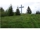
 | Dom Trilobit - Potoški Stol (via Rida)
Potoški Stol is located between Hochstuhl and Weinasch on the border with Austria. Just a few metres below the grassy peak, a cross is erected. T...
4 h |
 | Dolina potoka Žep - Veliki Travnik
Veliki Travnik, or Turnovka as the locals call it, is located on the western edge of the Smrekov Mountains. From the top of the hill, where a woo...
2 h 45 min |
 | Bistra - Veliki Travnik
Veliki Travnik, or Turnovka as the locals call it, is located on the western edge of the Smrekov Mountains. From the top of the hill, where a woo...
3 h 45 min |
 | Robanov kot - Strelovec
This scenic peak is located between two Alpine valleys, the Logarska dolina and Robanov Kot. The view from the top is the most beautiful of the m...
3 h |
 | Mače - Cjanovca (Mačenska pot and on SE ridge)
Cjanovca is the peak east of Storžič and south of Sredni vrh. It is a peak that can be seen from Kranj and the surrounding area. The southern slo...
3 h 35 min |
| Mače - Cjanovca (over Kozjek and on SE ridge)
Cjanovca is the peak east of Storžič and south of Sredni vrh. It is a peak that can be seen from Kranj and the surrounding area. The southern slo...
3 h 45 min |
| Mače - Cjanovca (Mačenska pot and via Dolga njiva)
Cjanovca is the peak east of Storžič and south of Sredni vrh. It is a peak that can be seen from Kranj and the surrounding area. The southern slo...
3 h 30 min |
| Mače - Cjanovca (via Kozjek and Dolga njiva)
Cjanovca is the peak east of Storžič and south of Sredni vrh. It is a peak that can be seen from Kranj and the surrounding area. The southern slo...
3 h 25 min |
 | Mislinja - Rogla (via Tolsti Vrh)
Rogla is the peak in the middle of the ski resort of the same name. The summit is woded with a small clearing on which stands a lookout tower. Th...
4 h 15 min |
 | Mislinja - Črni vrh
Črni vrh is the highest peak of Pohorje. Being partly unspoilt, Velika Kopa, Uršlja gora and the Kamnik and Savinja Alps can be seen behind. Part...
2 h 30 min |
 | Kurnikovo sedlo - Hochobir (Ojstrc) (footpath)
Hochobir (Hochobir) is the highest peak of a small mountain range called Obir. It is located west of Železna Kapla (Eisenkappel) on the Austrian ...
3 h 5 min |
 | Ukanc - Vogel (via planina Zadnji Vogel)
When you hear the name Vogel, many people first think of the Vogel ski resort, which is located near the peak of the same name. From the north si...
4 h 30 min |
 | Ukanc - Vogel (via Globoko)
When you hear the name Vogel, many people first think of the Vogel ski resort, which is located near the peak of the same name. From the north si...
4 h 15 min |
 | Tolminske Ravne - Vogel (on mule track)
When you hear the name Vogel, many people first think of the Vogel ski resort, which is located near the peak of the same name. From the north si...
3 h 30 min |
| Tolminske Ravne - Vogel (on mule track and over Globoko)
When you hear the name Vogel, many people first think of the Vogel ski resort, which is located near the peak of the same name. From the north si...
4 h 15 min |
 | Poštarski dom pod Plešivcem - Uršlja gora (Plešivec) (via Kozarnica)
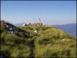
Uršlja gora or Plešivec is a lookout mountain between Slovenj Gradec and Črna na Koroškem. On the top or just below it stands the Church of St Ur...
2 h 30 min |
| Poštarski dom pod Plešivcem - Uršlja gora (Plešivec) (via Kal)
Uršlja gora or Plešivec is a lookout mountain between Slovenj Gradec and Črna na Koroškem. On the top or just below it stands the Church of St Ur...
2 h 45 min |
 | Ivarčko jezero - Uršlja gora (Plešivec) (Železarska pot)
Uršlja gora or Plešivec is a lookout mountain between Slovenj Gradec and Črna na Koroškem. On the top or just below it stands the Church of St Ur...
2 h 45 min |
 | Ivarčko jezero - Uršlja gora (Plešivec) (via Kozji hrbet)
Uršlja gora or Plešivec is a lookout mountain between Slovenj Gradec and Črna na Koroškem. On the top or just below it stands the Church of St Ur...
3 h |
 | Žerjav - Uršlja gora (Plešivec)
Uršlja gora or Plešivec is a lookout mountain between Slovenj Gradec and Črna na Koroškem. On the top or just below it stands the Church of St Ur...
3 h 15 min |
 | Učja - Monte Guarda/Skutnik
Monte Guarda is a peak located north of the Učje River on the border with Itali. The summit offers a beautiful view of the Kanin mountain group, ...
3 h 45 min |
 | Drežniške Ravne - Krasji vrh (via snežna jama)
Krasji vrh is located between Bovec and Kobarid on the Polovnik mountain ridge. At 1773m, Krasji vrh is also the highest peak of the ridge, offer...
3 h |
 | Valbruna/Ovčja vas - Svete Višarje / Monte Lussari
Svete Višarje is a pilgrimage site for Slavs, Germans and Romans. As early as the 16th century, the mountain was called the God's Way of the Thre...
2 h 30 min |
 | Žabnice / Camporosso in Valcanale - Svete Višarje / Monte Lussari
Svete Višarje is a pilgrimage site for Slavs, Germans and Romans. As early as the 16th century, the mountain was called the God's Way of the Thre...
2 h 30 min |
 | Podpeca (Mitnek) - Petzen (Kordeschkopf) (Peca (Kordeževa glava)) (easy path)
Kordeževa glava, better known as Peca is the highest summit in the mountain chain Peca. It is located on the border with Austria above Mežiška do...
4 h 15 min |
 | Koča na Pikovem - Petzen (Kordeschkopf) (Peca (Kordeževa glava)) (via saddle Vrh šteng and on easy path)
Kordeževa glava, better known as Peca is the highest summit in the mountain chain Peca. It is located on the border with Austria above Mežiška do...
4 h 15 min |
| Topla (Burjak) - Petzen (Kordeschkopf) (Peca (Kordeževa glava)) (via Mala Peca and on easy path)
Kordeževa glava, better known as Peca is the highest summit in the mountain chain Peca. It is located on the border with Austria above Mežiška do...
4 h |
 | Podpeca (Helenski potok) - Mala Peca (via Mirjanca)
Mala Peca is the peak above the lodge on the eastern slopes of Pec. From the top, where the viewing platform stands, there is a beautiful view of...
3 h 20 min |
| Topla (Burjak) - Mala Peca
Mala Peca is the peak above the lodge on the eastern slopes of Pec. From the top, where the viewing platform stands, there is a beautiful view of...
2 h 30 min |
 | Dom v Lepeni - Velika Baba
Velika Baba is the highest peak of the eastern ridge above the Lepena valley. From the summit, which has a registration box, there is a beautiful...
4 h |
 | Bad Vellach - Kärntner Storschitz / Pristovški Storžič
Kärntner Storschitz is an extremely scenic peak above Jezersko. It offers a beautiful view of the northern flanks of the Grintovci Mountains, thr...
2 h 30 min |
 | Jasna - Ciprnik (via Mojčin dom)
A hidden and scenic peak above the Kranj ski slopes. To the east we can see the Martuljek Mountains and on the other side Jalovec, Ponce, Mojstro...
3 h |
| Kranjska Gora - Ciprnik (via Bedančev dom)
A hidden and scenic peak above the Kranj ski slopes. To the east we can see the Martuljek Mountains and on the other side Jalovec, Ponce, Mojstro...
2 h 55 min |
 | Zell-Pharre - Freiberg/Setiče
Freiberg / Freiberg (also Z'če or Žetiče) is a scenic mountain on the Austrian side of the Karavanke Mountains. From the top with a cross there i...
2 h 30 min |
 | Deutcher Peter / Dajčpeter - Ferlacher Horn / Grlovec
Ferlacher Horn is a mountain with a large cross on top. From the top, you have a beautiful view of Karawanks, part of the Julian and Carnic Alps....
3 h |
 | Petrovo Brdo - Krevl
Krevl is a 1515 m high peak located to the south of the Kobla ski area, more precisely between Koble Peak and Kravje Črna Gora. From the summit, ...
2 h 30 min |
 | Avsa - Monte Mataiur/Matajur
Monte Mataiur is a scenic mountain located on the border between Slovenia and Itali. From the top, you have a beautiful view of the Kobarid or Br...
2 h 30 min |
 | Masseris - Monte Mataiur/Matajur
Monte Mataiur is a scenic mountain located on the border between Slovenia and Itali. From the top, you have a beautiful view of the Kobarid or Br...
2 h 30 min |
 | Avsa - Monte Mataiur/Matajur (old path)
Monte Mataiur is a scenic mountain located on the border between Slovenia and Itali. From the top, you have a beautiful view of the Kobarid or Br...
2 h 30 min |
| Livek - Monte Mataiur/Matajur
Monte Mataiur is a scenic mountain located on the border between Slovenia and Itali. From the top, you have a beautiful view of the Kobarid or Br...
3 h |
 | Hermsberg - Dobratsch / Dobrač
Dobratsch is a massive mountain range located west of Belgrade. Its highest peak is the 2166m-high Kuhriegel, which has taken the name Dobratsch ...
4 h |
| Bleiberg Kreuth (Wurzach) - Dobratsch / Dobrač
Dobratsch is a massive mountain range located west of Belgrade. Its highest peak is the 2166m-high Kuhriegel, which has taken the name Dobratsch ...
4 h |
 | Zadnja vas - Šentanski vrh
Šentanski vrh, located in the Dobrča mountain range, only 5 minutes away from the main peak, offers a beautiful view of the central Karawanks, th...
3 h 5 min |
| Hudi Graben - Šentanski vrh (via Koča na Dobrči)
Šentanski vrh, located in the Dobrča mountain range, only 5 minutes away from the main peak, offers a beautiful view of the central Karawanks, th...
3 h 5 min |
| Slatna - Šentanski vrh
Šentanski vrh, located in the Dobrča mountain range, only 5 minutes away from the main peak, offers a beautiful view of the central Karawanks, th...
3 h 5 min |
 | Begunje (Preska) - Šentanski vrh
Šentanski vrh, located in the Dobrča mountain range, only 5 minutes away from the main peak, offers a beautiful view of the central Karawanks, th...
3 h 5 min |
| Bistrica pri Tržiču - Šentanski vrh
Šentanski vrh, located in the Dobrča mountain range, only 5 minutes away from the main peak, offers a beautiful view of the central Karawanks, th...
3 h |
| Brezje pri Tržiču - Šentanski vrh (by road)
Šentanski vrh, located in the Dobrča mountain range, only 5 minutes away from the main peak, offers a beautiful view of the central Karawanks, th...
2 h 50 min |
 | Brezje pri Tržiču - Šentanski vrh (po robu)
Šentanski vrh, located in the Dobrča mountain range, only 5 minutes away from the main peak, offers a beautiful view of the central Karawanks, th...
2 h 35 min |
| Brezje pri Tržiču - Šentanski vrh (on path Po robu and via Lešanska planina)
Šentanski vrh, located in the Dobrča mountain range, only 5 minutes away from the main peak, offers a beautiful view of the central Karawanks, th...
2 h 40 min |
 | Libinjska kosa - Sveto brdo
At 1752 metres, Sveto brdo is the second highest peak in Velebit. It is located in the south-eastern part of the mountain range and offers a beau...
3 h 20 min |
 | Dom v Lepeni - Mali Šmohor
Mali Šmohor is a scenic peak located south-east of Lake Krn. From the summit, which has a registration box, there is a beautiful view of the near...
4 h |
 | Rosenbach - Kleiner Frauenkogel/Koprivnjak
Kleiner Frauenkogel (Little Frauenkogel) is a 1754 m high peak located on the Austrian side of the Karavanke Mountains. From the top, where the c...
3 h 30 min |
 | Cave del Predil - Šober / Monte Sciober Grande
Šober is a 1845 m high peak located between Remšendol and the Jezersko Valley. From the top you can enjoy a beautiful view of the nearby Rabeljsk...
2 h 45 min |
 | Rudenska grapa - Gladki vrh (Ratitovec)
Gladki vrh is the most visited peak in the Ratitovec mountain range with an altitude of 1667 m. The uncultivated summit, on which the viewing pla...
4 h |
 | Bitenjska planina - Altemaver (Ratitovec)
Altemaver is the highest peak of Ratitovec at 1678 m. The grassy peak offers a beautiful view of Julian Alps, Jelovica, Karawanks, Kamnik Savinja...
2 h 30 min |
 | Koča pri Savici - Kser
Kser is a less distinct peak located in the ridge of the Lower Bohinj Mountains, more precisely between Tolminski Kuk and Mahavščko. The summit, ...
4 h 30 min |
 | Montemaggiore - Punta di Montemaggiore
Punta di Montemaggiore or Italian. Punta di Montemaggiore is a 1613 m high mountain located above the source of the River Nadija, on the Italian ...
3 h |
 | Baumgartnerhof - Maloško poldne / Mallestiger Mittagskogel
Maloško poldne or Mallestiger Mittagskogel in German is a 1823 m high peak located on the border between Slovenia and Austria, more precisely bet...
2 h 45 min |
 | Susalitch - Zajčnik
Zajčnik (also Blekova) is a 1746 m high peak located northeast of Voška. The partially vegetated peak, which borders between Slovenia and Austria...
3 h 35 min |
| Korpitch - Zajčnik
Zajčnik (also Blekova) is a 1746 m high peak located northeast of Voška. The partially vegetated peak, which borders between Slovenia and Austria...
3 h 35 min |
 | Ukanc - Visoki Orlov rob (via Žagarjev graben)
Visoki Orlov rob is an 1800 m high peak located in the immediate vicinity of the upper station of the single-seater Šija. The summit, located sli...
3 h 45 min |
 | Bachwinkl - Peter Wiechenthaler Hütte
Hut Peter Wiechenthaler Hütte is located on the summit of Kienalkopf in the Berchtesgaden Alps at an altitude of 1,752 metres. From the hut, whic...
2 h 30 min |
 | Parking Alpspitzbahn - Osterfelderkopf
Osterfelderkopf is a 2033 metre high peak in the Wetterstein mountain group. The summit is very well visited as it can also be reached by the Alp...
4 h 15 min |
 | Drežniške Ravne - Lopatnik
Lopatnik can be an accessible colon above the mountain pasture patch. Its diadem-shaped summit rises between the Vrata saddle and the Krnčice rid...
3 h |
 | Mislinja - Ostruščica (via Tolsti Vrh)
Ostruščica is a 1498 m high peak located west of the ski slopes at Rogla....
4 h 15 min |
 | Žabnice / Camporosso in Valcanale - Florjanka / Monte Florianca
Florjanka is a 1,653-metre-high mountain on the Italian side of the Julian Alps. At the top or just below it, there is a reservoir for snowmaking...
2 h 30 min |
 | Podrožca / Rosenbach - Kamnica (Komnica) / Ferlacher Spitze
Kamnica is a lookout mountain located on the Austrian side of Karawanks, more precisely north of Kepe. From the top, where there is a cross, a re...
3 h 55 min |
| Čemernica / Tschemernitzen - Kamnica (Komnica) / Ferlacher Spitze
Kamnica is a lookout mountain located on the Austrian side of Karawanks, more precisely north of Kepe. From the top, where there is a cross, a re...
3 h 40 min |
 | Losenheim (Parkplatz am Schneeberg) - Klosterwappen (Schneeberg) (via Schauerstein)
Schneeberg is the easternmost and, at the same time, the northernmost of the two-thousand peaks of the Alps, with its Kaiserstein (2061 m) and Kl...
4 h 15 min |
 | Planina Zajzera - Krniška glavica / Jof di Sompdogna
Krniška glavica (Jof di Sompdogna) is a 1,889-metre-high peak in the Western Julian Alps, north of Jôf di Montasioa. There is a cross on the look...
2 h 30 min |
 | Planina Zajzera - Krniška glavica / Jof di Sompdogna (path 639 and 652)
Krniška glavica (Jof di Sompdogna) is a 1,889-metre-high peak in the Western Julian Alps, north of Jôf di Montasioa. There is a cross on the look...
3 h 10 min |
 | Sankt Ilgen (Der Bodenbauer) - Buchbergkogel
...
2 h 30 min |
 | Oberort - Messnerin
...
2 h 45 min |
| Oberort (parkirišče Zeleno jezero) - Messnerin (Kamplsteig)
...
3 h 30 min |
 | Losenheim (Parkplatz am Schneeberg) - Kaiserstein (Schneeberg) (via Schauerstein)
...
4 h 3 min |
 | Niklasdorfgraben (Parkirišče Mugel) - Rosseck (čez Mugel)
...
2 h 30 min |
 | Parkirišče Hoyer - Speikkogel (Gleinalpe)
...
3 h 15 min |
 | Parkirišče Hoyer - Lenzmoarkogel (Gleinalpe)
...
3 h 30 min |