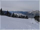
 | Bistriška planina - Dobrča
Dobrča is a 1634 m high mountain located between Begunje and Tržič. From the top, where the registration box with the stamp is located, we can se...
1 h 30 min |
 | Hibje - Dobrča (by road)
Dobrča is a 1634 m high mountain located between Begunje and Tržič. From the top, where the registration box with the stamp is located, we can se...
1 h 45 min |
 | Črni Kal - Blegoš (by road, via hut)
Blegoš is a 1562 m high mountain located between Selška and Poljane Sora. From the grassy summit, on which there is a stamp and a registration bo...
1 h 30 min |
 | Črni Kal - Blegoš (direct way)
Blegoš is a 1562 m high mountain located between Selška and Poljane Sora. From the grassy summit, on which there is a stamp and a registration bo...
1 h 10 min |
 | Črni kal - Blegoš (via Prva ravan)
Blegoš is a 1562 m high mountain located between Selška and Poljane Sora. From the grassy summit, on which there is a stamp and a registration bo...
1 h 20 min |
 | Hunting cottage (Davča) - Porezen
Porezen is a 1630 m high mountain located between Davča and Baška Grapa. From the top, where a large NOB monument stands, we have a beautiful vie...
1 h 45 min |
 | Podhočar - Porezen
Porezen is a 1630 m high mountain located between Davča and Baška Grapa. From the top, where a large NOB monument stands, we have a beautiful vie...
1 h 50 min |
 | Rateče - Ofen/Peč (footpath)
Peč (also Tromeja), in Italian Monte Forno and in German Dreiländereck or Ofen, is a 1508 m high peak located on the tri-border between Slovenia,...
1 h 40 min |
 | Rateče - Ofen/Peč (eastern path, past bivouac and on footpath)
Peč (also Tromeja), in Italian Monte Forno and in German Dreiländereck or Ofen, is a 1508 m high peak located on the tri-border between Slovenia,...
1 h 45 min |
| Rateče - Ofen/Peč (eastern path, past bivouac and on mule track)
Peč (also Tromeja), in Italian Monte Forno and in German Dreiländereck or Ofen, is a 1508 m high peak located on the tri-border between Slovenia,...
1 h 50 min |
 | Javorje - Stari vrh (via Koča na Starem vrhu)
Stari vrh is a 1217 m high mountain located above the ski resort of the same name. There is no view from the summit itself due to the forest, but...
1 h 35 min |
 | Javorje - Stari vrh (via Prehodi)
Stari vrh is a 1217 m high mountain located above the ski resort of the same name. There is no view from the summit itself due to the forest, but...
1 h 30 min |
 | Zgornja Sorica - Dravh
Dravh is a 1547 m high peak located between Sorica and Soriška mountain pasture. From the uncultivated summit, we have a beautiful view of Škofje...
1 h 30 min |
 | Zgornja Sorica - Lajnar
Lajnar is a 1549 m high mountain located north of Soriška mountain pasture. From the top, which is also the highest point of the ski resort, we h...
1 h 40 min |
 | Hunting cottage Vojkovo - Vojkova koča na Nanosu
Vojkova koča is located on the southern edge of the Nanoše plateau, close to Pleše, a peak that is clearly visible from the motorway. From the hu...
1 h 45 min |
 | Kramarica - Smrekovec (via Bukov stan)
Smrekovec is a volcanic mountain on the eastern edge of the Smrekov Mountains. The extensive grassy summit, on which stands a pyramid with a regi...
1 h 30 min |
| Kramarica - Smrekovec (by road)
Smrekovec is a volcanic mountain on the eastern edge of the Smrekov Mountains. The extensive grassy summit, on which stands a pyramid with a regi...
1 h 30 min |
 | Krnica - Kucelj na Čavnu (via Veliki Rob)
Kucelj is located on the southern slopes of Trnovo Forest, north-west of the Vipava valley. From the uncultivated summit on which the cross stand...
1 h 40 min |
 | Predmeja - Mali Modrasovec
Mali Modrasovec is a peak north of the house on Čavno in the Trnovo forest. On the top, surrounded by wods, there is a small house and a control ...
1 h 25 min |
 | Predmeja - Veliki Modrasovec
Veliki Modrasovec is located in the southern part of the Trnovo Forest near Predmeja. On the top of the hill is an old military building which yo...
1 h 35 min |
| Predmeja (tunnels) - Veliki Modrasovec
Veliki Modrasovec is located in the southern part of the Trnovo Forest near Predmeja. On the top of the hill is an old military building which yo...
1 h 50 min |
 | Mala Lazna - Mali Golak
Mali Golak is the highest of the Golaks. It was named not because it was the smallest but because it had the smallest mountain pasture. On the ma...
1 h 25 min |
 | Kozarnice - Mali Golak
Mali Golak is the highest of the Golaks. It was named not because it was the smallest but because it had the smallest mountain pasture. On the ma...
1 h 5 min |
 | Kozarnice - Srednji Golak (via Mali Golak)
Srednji Golak is located between Mali and Veliki Golak on the plateau of the Trnovo Forest above Predmeja. The summit is covered with dwarf pines...
1 h 50 min |
 | Grda draga - Mali Snežnik
Mali Snežnik is a peak on the west ridge of Snežnika. Vrh, which is covered with dwarf pines, has a fine view of the neighbouring Veliki Snežnik ...
1 h 30 min |
 | Koča na Naravskih ledinah - Uršlja gora (Plešivec)
Uršlja gora or Plešivec is a lookout mountain between Slovenj Gradec and Črna na Koroškem. On the top or just below it stands the Church of St Ur...
1 h 45 min |
 | St. John the Baptist on Ojstrica - Huhnerkogel/Košenjak
Huhnerkogel lies north of Dravograd and the River Drava on the border with neighbouring Austria. Huhnerkogel is accessible on foot or by car from...
1 h 30 min |
 | Avsa - Mrzli vrh (on Matajur) (old path)
Mrzli vrh is a 1358-metre high peak located in the Matajur Mountains. From the top, where there is a viewing platform and a registration box with...
1 h 25 min |
 | Plajberški graben / Bleiberger Graben - Sinacher Gupf / Psinski vrh
Sinacher Gupf (on maps we mostly see the name Psinski vrh) / Sinacher Gupf is a peak located north of the main chain Karawanks, more precisely no...
1 h 35 min |
 | Strugarjach / Strugarje - Sinacher Gupf / Psinski vrh
Sinacher Gupf (on maps we mostly see the name Psinski vrh) / Sinacher Gupf is a peak located north of the main chain Karawanks, more precisely no...
1 h 30 min |
 | Čemšenik - Črni vrh (Čemšeniška planina)
Črni vrh is the highest peak of Čemšeniška mountain pasture and with a height of 1204 m it is the second highest peak in the Posavje - Zasavje hi...
1 h 30 min |
 | Planinski dom Vrhe - Črni vrh (Čemšeniška planina)
Črni vrh is the highest peak of Čemšeniška mountain pasture and with a height of 1204 m it is the second highest peak in the Posavje - Zasavje hi...
1 h 30 min |
 | Ljubelj - Polna peč
Polna peč, also marked on maps as Ravna peč, is located above the Ljubljana Tunnel. From the top, which is somewhat precipitous, there is a beaut...
1 h 15 min |
 | Bučan - Polna peč
Polna peč, also marked on maps as Ravna peč, is located above the Ljubljana Tunnel. From the top, which is somewhat precipitous, there is a beaut...
1 h 30 min |
 | Črni Vrh (Grom) - Javornik above Črni vrh
Javornik is a forested peak located southeast of Črnji Vrho. In 1972, a lookout tower was erected on the summit, which reaches above the treetops...
1 h 10 min |
 | Platak - Snježnik (via grlo)
Snježnik is a scenic mountain in the western part of Gorski Kotar. The summit offers a beautiful view of the Kvarner islands, the Gulf of Reška, ...
1 h 30 min |
| Platak - Snježnik (via crest)
Snježnik is a scenic mountain in the western part of Gorski Kotar. The summit offers a beautiful view of the Kvarner islands, the Gulf of Reška, ...
1 h 30 min |
 | Bistriška planina - Šentanski vrh
Šentanski vrh, located in the Dobrča mountain range, only 5 minutes away from the main peak, offers a beautiful view of the central Karawanks, th...
1 h 35 min |
 | Preval Vrh Ravni - Kojca
Kojca is a scenic peak rising south of Baška Grape. The hay pile on the top offers a beautiful view of the Lower Bohinj Mountains, the Škofjelošk...
1 h 20 min |
 | Zakojca - Kojca
Kojca is a scenic peak rising south of Baška Grape. The hay pile on the top offers a beautiful view of the Lower Bohinj Mountains, the Škofjelošk...
1 h 45 min |
 | Orehek - Kojca
Kojca is a scenic peak rising south of Baška Grape. The hay pile on the top offers a beautiful view of the Lower Bohinj Mountains, the Škofjelošk...
1 h 55 min |
| Jesenica - Kojca
Kojca is a scenic peak rising south of Baška Grape. The hay pile on the top offers a beautiful view of the Lower Bohinj Mountains, the Škofjelošk...
1 h 45 min |
 | Koča na Starem vrhu - Mladi vrh (via Stari vrh)
Mladi vrh is the senior neighbour of the better known Stari vrh, from which it is separated by a saddle. The top is covered with a sparse beech f...
1 h 40 min |
 | Javorje - Mladi vrh (via Prehodi)
Mladi vrh is the senior neighbour of the better known Stari vrh, from which it is separated by a saddle. The top is covered with a sparse beech f...
1 h 45 min |
 | Podkraj - Sveti Duh (Hrušica)
The Sveti Duh Church is located just a few metres below the eponymous peak on the slopes of the forested Hrušice, a mountain range between Col, L...
1 h 15 min |
 | Koča na planini Stador - Kobilja glava
Kobilja glava is a 1475 m high peak located east of Tolmin. From the top with a cross, we have a beautiful view of the Krn, the Lower Bohinj Moun...
1 h 15 min |
 | Prtovč - Gladki vrh (Ratitovec) (via Razor)
Gladki vrh is the most visited peak in the Ratitovec mountain range with an altitude of 1667 m. The uncultivated summit, on which the viewing pla...
1 h 35 min |
| Prtovč - Gladki vrh (Ratitovec) (via Po(v)den)
Gladki vrh is the most visited peak in the Ratitovec mountain range with an altitude of 1667 m. The uncultivated summit, on which the viewing pla...
1 h 35 min |
| Torka - Gladki vrh (Ratitovec)
Gladki vrh is the most visited peak in the Ratitovec mountain range with an altitude of 1667 m. The uncultivated summit, on which the viewing pla...
1 h 20 min |
 | Prtovč - Altemaver (Ratitovec) (via Razor)
Altemaver is the highest peak of Ratitovec at 1678 m. The grassy peak offers a beautiful view of Julian Alps, Jelovica, Karawanks, Kamnik Savinja...
1 h 50 min |
| Prtovč - Altemaver (Ratitovec) (via Po(v)den)
Altemaver is the highest peak of Ratitovec at 1678 m. The grassy peak offers a beautiful view of Julian Alps, Jelovica, Karawanks, Kamnik Savinja...
1 h 50 min |
| Torka - Altemaver (Ratitovec)
Altemaver is the highest peak of Ratitovec at 1678 m. The grassy peak offers a beautiful view of Julian Alps, Jelovica, Karawanks, Kamnik Savinja...
1 h 35 min |
 | Zgornje Danje - Altemaver (Ratitovec)
Altemaver is the highest peak of Ratitovec at 1678 m. The grassy peak offers a beautiful view of Julian Alps, Jelovica, Karawanks, Kamnik Savinja...
1 h 45 min |
| Podkraj - Srednja gora (Hrušica) (east path)
Srednja gora is a 1275 m high peak located in the central part of the forested Hrušice. The peak is covered with forest, and just a few minutes w...
1 h 30 min |
| Podkraj - Srednja gora (Hrušica) (west path)
Srednja gora is a 1275 m high peak located in the central part of the forested Hrušice. The peak is covered with forest, and just a few minutes w...
1 h 45 min |
 | Podkraj - Streliški vrh (Hrušica) (east path)
Streliški vrh is a 1266 m high mountain located in the central part of the forested Hrušice. From the top, which is partly covered with forest, w...
1 h 30 min |
| Podkraj - Streliški vrh (Hrušica) (west path)
Streliški vrh is a 1266 m high mountain located in the central part of the forested Hrušice. From the top, which is partly covered with forest, w...
1 h 20 min |
 | Ravne - Cerk
At 1192 m, Cerk is the highest peak of Borovška Gora, a mountain range located between the Kolpa River valley and Goteniškje Snežnik. From the to...
1 h 30 min |
 | Jeršiče - Mali Javornik (Javorniki)
Mali Javornik is a 1219 m high mountain located in the crest of the forested Javorniki Ridge. There is no view from the top due to the forest, bu...
1 h 50 min |
 | Zgornje Danje - Kremant (Ratitovec)
Kremant is a 1654 m high peak located in the western part of Ratitovec. From the top, where a stamp is attached to a metal pole, we have a beauti...
1 h 45 min |
 | Dom na Paškem Kozjaku - Štrukljev vrh
Štrukljev vrh is one of the three main peaks of Paški Kozjak, a 10 km long, narrow and very steep limestone mountain range between the Paka and H...
1 h 30 min |
 | Avsa - Srednji vrh (on Matajur) (old path)
Srednji vrh is a 1320-metre high grassy peak located in the Matajur mountain range. The summit, which is a take-off point for paragliders, offers...
1 h 20 min |
 | St. John the Baptist on Ojstrica - Kozji vrh (at Košenjak)
Kozji vrh is a 1383-metre-high peak located above Pernice, and its height makes it the highest peak in the municipality of Muta....
1 h 35 min |
 | Bodenbauer - Kosmatica / Kosmatitza
Kosmatica is a 1659 m high peak located entirely on the Austrian side of Karawanks, north of Vrtača. The summit, which is partly covered by fores...
1 h 45 min |
 | Mönichkirchen - Steinerne Stiege
Steinerne Stiege is a less prominent peak in the Wechsell mountain range....
1 h 35 min |
 | St. Vinzenz (St. Vinzenz) - Dreieckkogel
...
1 h 35 min |
 | Lišnjak (cesta na Promino) - Čavnovka (Promina) (mimo koče in po peš poti)
...
1 h 45 min |
 | Lišnjak (cesta na Promino) - Čavnovka (Promina) (mimo koče in po cesti)
...
1 h 45 min |
 | Straßegg - Hochschlag
...
1 h 45 min |