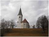
 | Vidrga - Zasavska Sveta gora (on forest footpath)
Zasavska Sveta gora is a popular excursion point located between Litija and Izlaki. From the top, where the parish church of the Nativity of the ...
1 h 30 min |
| Vidrga - Zasavska Sveta gora (on a cart track)
Zasavska Sveta gora is a popular excursion point located between Litija and Izlaki. From the top, where the parish church of the Nativity of the ...
1 h 30 min |
 | Okroglice - Sveti Lovrenc above Okroglice
The Church of Saint Lovrenc is located east of Zidanega Most, above the village of Okroglice. From the top of the hill, where the clusius cowslip...
1 h |
 | Podgorje - Kojnik (via hunting cottage)
Kojnik is a partially vegetated peak located in the southern part of the Podgorje Karst near the Slovenian-Croatian border. From the top of the s...
1 h 30 min |
 | Tržič - Kamnek (Milanova pot)
Kamnek (Kamnik on maps, but also Kamnjek) is a scenic peak above Tržič....
1 h 5 min |
 | Tržič (Slap) - Kamnek (via Dobrivc)
Kamnek (Kamnik on maps, but also Kamnjek) is a scenic peak above Tržič....
1 h |
 | Podpeč - Grmada on Mala gora
Grmada (also Grmada nad Ortnek) is an 887 m high peak located above the village of Vrh pri Poljanah in the Mala Gora mountain range. Just a few m...
1 h 35 min |
 | Prelesje - Sivka
Sivka is a grassy peak located in the westernmost part of the Polhograje Hills. In good weather, the peak offers a magnificent view from Snežnik ...
1 h |
 | Planina - Grmada (Planinska gora)
Grmada is an 873m high peak rising west of Planinsko Polje. The summit is overgrown, but from the lookout point just below the summit we have a b...
1 h |
 | Planina (Dolnja Planina) - Grmada (Planinska gora) (via Zavrtniki)
Grmada is an 873m high peak rising west of Planinsko Polje. The summit is overgrown, but from the lookout point just below the summit we have a b...
1 h 5 min |
| Planina (Dolnja Planina) - Grmada (Planinska gora) (via Sv. Duh)
Grmada is an 873m high peak rising west of Planinsko Polje. The summit is overgrown, but from the lookout point just below the summit we have a b...
1 h 5 min |
 | Olševek - Štefanja gora (via Apnišče)
Štefanja gora on which the Church of St Stephen stands, is located above Cerkly in Gorenjska. Just 10 metres below the summit, the Pr'Mežnarju ex...
1 h 15 min |
 | Preddvor - Štefanja gora (on footpath)
Štefanja gora on which the Church of St Stephen stands, is located above Cerkly in Gorenjska. Just 10 metres below the summit, the Pr'Mežnarju ex...
1 h 20 min |
 | Smrečje - Goli vrh
Goli vrh, also known as Golni vrh on maps, is a nondescript forested peak located above the scattered settlement of Goli Vrh. There is no view fr...
1 h 30 min |
 | Bohinjska Češnjica - Rudnica
Rudnica is a scenic mountain located between the Lower and Upper Bohinj Valley. From the top, where there is a registration box with a stamp and ...
1 h 30 min |
| Srednja vas (Senožeta) - Rudnica
Rudnica is a scenic mountain located between the Lower and Upper Bohinj Valley. From the top, where there is a registration box with a stamp and ...
1 h 30 min |
 | Ledinsko Razpotje - Gradišče (above Spodnja Idrija) (steep path)
Gradišče is a 998-metre-high peak that separates the Ledine plateau in the north-western part of the Rovtarski hills from the Idrijca valley. A t...
1 h |
 | Ledinsko Razpotje - Gradišče (above Spodnja Idrija) (gentle path)
Gradišče is a 998-metre-high peak that separates the Ledine plateau in the north-western part of the Rovtarski hills from the Idrijca valley. A t...
1 h 15 min |
 | Njivica - Sveti Primož in Felicijan (Jamnik)
The Church of St. Primož and Felicijan on Jamnik, is situated on a scenic grassy ridge rising between Kropa and Podblica. From the church or its ...
1 h 10 min |
 | Brezovica - Sveti Primož in Felicijan (Jamnik)
The Church of St. Primož and Felicijan on Jamnik, is situated on a scenic grassy ridge rising between Kropa and Podblica. From the church or its ...
1 h 20 min |
| Češnjica pri Kropi - Sveti Primož in Felicijan (Jamnik) (via Berigla)
The Church of St. Primož and Felicijan on Jamnik, is situated on a scenic grassy ridge rising between Kropa and Podblica. From the church or its ...
1 h 20 min |
| Kropa (Slovenska peč) - Sveti Primož in Felicijan (Jamnik)
The Church of St. Primož and Felicijan on Jamnik, is situated on a scenic grassy ridge rising between Kropa and Podblica. From the church or its ...
1 h 10 min |
 | Rodik - Sveti Socerb (Artviže)
The Church of St. Socerbo is situated on a hill overloking the village of Artviže, which is the highest peak in Brkina with its 817 m. The church...
1 h 20 min |
 | Gorenji Novaki (Mrovlje) - Škofje
Škofje is a 973 m high peak located above the villages of Čeplez, Planina pri Cerknem and Podpleče. The peak itself, on which stands a small conc...
1 h |
 | Trojane - Lipovec
Lipovec is an 848 m high peak located above the pastures of Lipovec. In good weather, the summit offers a view of Posavsko hribovje, Kum, Menino ...
1 h 30 min |
 | Jasen - Ahac
Ahac or St. Ahac is a 799 m high peak located east of Ilirska Bistrica. The summit, which is home to a registration box, a cross and the ruins of...
1 h |
 | Šembije - Gradišče (Čepan)
Gradišče aka Čepan is a 791 m high peak located in the mountain ridge between Šembije and Pivka. From the top, which with its 791 m is also the h...
1 h 20 min |
 | Tržič (Čegelše) - Veliki vrh above Završnik
Veliki vrh above Završnik is a 968 m high mountain located in the Pirmance ridge, north to north-east of Tržič. From the grassy summit, where the...
1 h 20 min |
| Podljubelj - Veliki vrh above Završnik
Veliki vrh above Završnik is a 968 m high mountain located in the Pirmance ridge, north to north-east of Tržič. From the grassy summit, where the...
1 h 20 min |
 | Činžat - Lobnikov vrh
Lobnikov vrh is a forested peak above the Drava Valley, situated between Fala and Ruta. From the east, it loks like a solitary rock due to its di...
1 h |
 | Brezje nad Kamnikom - Vovar (western way)
An obscure hill in front of the Kamnik mountains. Recently covered by storms, it has been covered with wood harvesting tracks.There is also a sma...
1 h |
| Brezje nad Kamnikom - Vovar (northern way)
An obscure hill in front of the Kamnik mountains. Recently covered by storms, it has been covered with wood harvesting tracks.There is also a sma...
1 h |
 | Žiri - Javorč
Javorč is a 901-metre-high peak located to the north-east of Žiri. The summit, where the registration box with the registration book is located, ...
1 h 15 min |
 | Col - Špiček (Špečk)
Špiček (locals call it Špečk) is a peak located north to north-east of Cola. On the summit is a cross in honour of St Hubert and commemorating th...
55 min |
 | Col - Špiček (Špečk) (via Križna gora)
Špiček (locals call it Špečk) is a peak located north to north-east of Cola. On the summit is a cross in honour of St Hubert and commemorating th...
1 h 10 min |
 | Col - Križna gora above Col (via Špiček)
Križna gora is a 957 m high peak located north of Cola. The summit, which is forested on the north side, offers a beautiful view to the east, sou...
1 h 10 min |
 | Col - Križna gora above Col
Križna gora is a 957 m high peak located north of Cola. The summit, which is forested on the north side, offers a beautiful view to the east, sou...
55 min |
 | Logatec (Gorenja vas) - Šenčurjev vrh (via Žibrše)
Šenčurjev vrh is a 725-metre-high hill located above the settlement Žibrše, between Logatec, Hotedršica and Rovtami. At the top, which offers a b...
1 h 30 min |
 | Olševek - Apnišče (west path)
Apnišče is a 740 m high mountain located between Možjanca and Štefanja gora. It is the highest point of the Šenčur municipality. There is a bench...
55 min |
 | Olševek - Apnišče (via Šterna)
Apnišče is a 740 m high mountain located between Možjanca and Štefanja gora. It is the highest point of the Šenčur municipality. There is a bench...
55 min |
| Adergas - Apnišče (via Šterna)
Apnišče is a 740 m high mountain located between Možjanca and Štefanja gora. It is the highest point of the Šenčur municipality. There is a bench...
1 h |
 | Preddvor - Apnišče (on footpath)
Apnišče is a 740 m high mountain located between Možjanca and Štefanja gora. It is the highest point of the Šenčur municipality. There is a bench...
1 h 15 min |
 | Blejska Dobrava (cemetery) - Hom pri Bledu (via Katarina)
Hom is an 834 m high hill that rises north above the villages Zasip and Podhom near Bled, or south of the village Blejska Dobrava near Jesenice. ...
1 h 25 min |
 | Blejska Dobrava (cemetery) - Hom pri Bledu (on east slope)
Hom is an 834 m high hill that rises north above the villages Zasip and Podhom near Bled, or south of the village Blejska Dobrava near Jesenice. ...
1 h 5 min |
 | Poljane (Spodnje Gorje) - Boršt (by road)
Boršt is a 931 m high vegetated peak located 4 km north-west of Bled, or east of the Mežakla plateau. Between it and the neighbouring peak of Hom...
1 h |
 | Kočna - Boršt (via Vrše)
Boršt is a 931 m high vegetated peak located 4 km north-west of Bled, or east of the Mežakla plateau. Between it and the neighbouring peak of Hom...
1 h 20 min |
 | Trate (Blejska Dobrava) - Boršt
Boršt is a 931 m high vegetated peak located 4 km north-west of Bled, or east of the Mežakla plateau. Between it and the neighbouring peak of Hom...
1 h |
 | Ukova (Jesenice) - Mirca (via Pekova plan'ca)
Mirca (dialect Merca) is one of the peaks of the southern Karavanke mountain range with an altitude of 1025 m. It rises north above the centre of...
1 h 20 min |
 | Murova - Mirca
Mirca (dialect Merca) is one of the peaks of the southern Karavanke mountain range with an altitude of 1025 m. It rises north above the centre of...
1 h 10 min |
 | Možjanca - Kopa (Partizanski vrh)
Kopa, also Partizanski vrh, is a 1024-metre high mountain located west of the Davovec saddle, which is west to south-west of Krvavec. There is a ...
1 h 30 min |
 | Možjanca - Skutman
Skutman is a lesser-known peak located above the left bank of the Kokra River and north of Štefanje Gora. The summit is marked by a metal sign wi...
1 h 25 min |
 | Možjanca - Skutman (via Zapečnikova planina)
Skutman is a lesser-known peak located above the left bank of the Kokra River and north of Štefanje Gora. The summit is marked by a metal sign wi...
1 h 25 min |
| Kokra (resting place Kokra-sotočje) - Skutman
Skutman is a lesser-known peak located above the left bank of the Kokra River and north of Štefanje Gora. The summit is marked by a metal sign wi...
1 h 10 min |
 | Mežica - Andrejev vrh (by cart track)
Andrejev vrh is a forested peak located between Mežica and Lesa. There is a bench on the top and a registration box with a registration book....
1 h 15 min |
| Mežica - Andrejev vrh (past the chapel)
Andrejev vrh is a forested peak located between Mežica and Lesa. There is a bench on the top and a registration box with a registration book....
1 h 20 min |
| Leše - Andrejev vrh (via Leše churches and via chapel)
Andrejev vrh is a forested peak located between Mežica and Lesa. There is a bench on the top and a registration box with a registration book....
1 h 35 min |
| Leše - Andrejev vrh (past Leše churches and on cart track)
Andrejev vrh is a forested peak located between Mežica and Lesa. There is a bench on the top and a registration box with a registration book....
1 h 30 min |
 | Podblica - Sveti Križ above Selca (via Sleme)
The Sveti Križ above Selca church is situated on a lookout point, which offers a beautiful view over part of the Škofjeloško hribovje....
1 h 30 min |
 | Senično - Planica (Paragliding site Gozd) (gentle path)
Planica is a 926-metre-high peak located above the village of Gozd. From the top, where the JPK Kriška gora hut is located, we have a beautiful v...
1 h 15 min |
| Senično - Planica (Paragliding site Gozd) (steep path)
Planica is a 926-metre-high peak located above the village of Gozd. From the top, where the JPK Kriška gora hut is located, we have a beautiful v...
1 h 10 min |
| Pristava - Planica (Paragliding site Gozd)
Planica is a 926-metre-high peak located above the village of Gozd. From the top, where the JPK Kriška gora hut is located, we have a beautiful v...
1 h 20 min |
 | Šenturška Gora - Prgozdnik (Martinova pot)
Prgozdnik is a 1013-metre-high peak located on the ridge of the same name, between the settlements of Ambrož pod Krvavcem, Šenturška Gora, Apno a...
1 h 5 min |
 | Apno - Prgozdnik (Martinova pot)
Prgozdnik is a 1013-metre-high peak located on the ridge of the same name, between the settlements of Ambrož pod Krvavcem, Šenturška Gora, Apno a...
1 h 10 min |
 | Bukovo - Črvov vrh
Črvov vrh, also known as Črvov grič, is the highest peak of the Šentviška plateau, rising above the right bank of the Idrijca and the left bank o...
1 h 30 min |
| Šentviška Gora - Črvov vrh
Črvov vrh, also known as Črvov grič, is the highest peak of the Šentviška plateau, rising above the right bank of the Idrijca and the left bank o...
1 h 10 min |
 | Bukovo - Bukovski vrh
Bukovo vrh (918 m) is located above the settlement Bukovo Vrh, more precisely above the homestead at Pircu.From the grassy summit we have a beaut...
1 h 20 min |
| Šentviška Gora - Bukovski vrh
Bukovo vrh (918 m) is located above the settlement Bukovo Vrh, more precisely above the homestead at Pircu.From the grassy summit we have a beaut...
1 h 30 min |
 | Podgora - Vrh Slajke
Vrh Slajke is a 790-metre-high hill located above Hotavlje, on the right bank of the Kopačnice River. From the top, where the antenna tower stand...
1 h 25 min |
 | Jazne (Lanišar) - Krog (Ledinski grič)
Krog is a 940 m high peak located on the western part of the Ledinski grič ridge, which is situated between the Jerešča and Ledinščica watercours...
1 h 35 min |
| Ledinsko Razpotje - Krog (Ledinski grič)
Krog is a 940 m high peak located on the western part of the Ledinski grič ridge, which is situated between the Jerešča and Ledinščica watercours...
1 h 30 min |
 | Selca - Lepo brdo
Lepo brdo is a 778-metre-high hill located above the settlements of Selca and Studeno....
1 h |
 | Veliko Tinje - Repnikov vrh
Repnikov vrh is a 988 m high peak on Pohorje, located between Mountain pasture below Šumik and Urh. The peak is located in the middle of the fore...
1 h 25 min |
 | Lovrenc na Pohorju (cemetery) - Koglerjev vrh (via Hožičev vrh)
Koglerjev vrh is a 698-metre-high, forested peak located south-west of the Šlaus-Kogler organic farm, which is above the village of Lovrenc na Po...
1 h |