Planina Podvežak - Mala Ojstrica
Starting point: Planina Podvežak (1500 m)
| Lat/Lon: | 46,3319°N 14,6726°E |
| |
Time of walking: 2 h 30 min
Difficulty: easy marked way
Altitude difference: 517 m
Altitude difference po putu: 650 m
Map: Kamniške in Savinjske Alpe 1:50.000
Recommended equipment (summer):
Recommended equipment (winter): ice axe, crampons
Views: 62.334
 | 2 people like this post |
Access to the starting point:
First drive to Luče, then continue into the Podvolovjek valley (direction Kamnik and Kranjski Rak). At the road marker between 11 and 11. 5 km, you will come to a small crossroads where the road to the right branches off towards Farmer Planinšek and the mountains Podveža, Ravne and Vodole (the branch is marked). Take this initially still asphalted road and follow it at the crossroads in the route mountain pasture Podveža. After a relatively long and in the upper part also worse macadam road you will reach the parking lot under mountain pasture Podveža (at the starting point there is a ramp and a number of mountain signs).
From Kamnik, drive towards the Črnivec Pass, but only as far as the crossroads, where the road to Kranjski Rak turns sharp left (the turn-off is marked and is located only 500 m before the pass). At the crossroads at Kranjski Rak, continue straight ahead on the main road, which starts descending into the Podvolovjek valley. In the valley, just 100 m after the Gams bar, you will reach a crossroads where the road to the left branches off towards the farmer Planinšek and the mountains Podveža, Ravne and Vodole (the branch is marked). Follow the description above.
Path description:
From the parking lot, take the footpath (or road) in the route mountain pasture Podveža. Both the road and the footpath, which crosses a forest road during the ascent, lead us in 15 minutes of moderate ascent to the shepherd's hut at mountain pasture Podveža, from which we have a beautiful view towards Rogatec and Lepenatka.
From mountain pasture continue along the marked, but at first less visible path, which soon goes into the forest. The path through the forest climbs a little steeper and then enters a small uncultivated valley, above which it completely flattens out. It is followed by a few minutes of crossing the slopes below the side ridge of the board, and then the path leads to a less visible crossroads, where an unmarked path branches off to the left, leading towards Deska and the Watercourse Lake. Continue straight on the marked path, which descends into a pleasant grassy plain, then turns slightly to the right and climbs through the dwarf pines zone. At the top of the climb, the path with the mountain pasture Vodole joins us from the right, and we continue left, crossing a pasture fence and after a few further steps we reach the Inkret's Well, which is located just a few metres off the path.
There is only a slight climb, and then the path lies down again and leads us under the relatively steep and avalanche-prone slopes of Tolstego vrh (Tolstego Peak). A little further on, a pleasant path leads us to a marked crossroads, where we continue slightly left in the direction of Korošice (slightly right, the chapel on Molička peč (mountain)). The path continues for some time crossing the slopes below Tolstim vrh, and then passes onto the plateau-like world of the Dleskovška plateau, which is interspersed with numerous potholes and caves. The path, which continues with a few short ascents and descents, then quickly leads us to a crossroads, where the path from Robanov Kot and mountain pasture Ravne joins us from the right.
Continue in the direction of Korošica along the path which ascends crosswise to the saddle between the lesser-known Koroška vrh on the left and Mala Ojstrica on the right.
From Sedelce (1900 m) continue right along the Kocbekova cesta in the direction of Ojstrica and Mala Ojstrica (straight down Kocbekov dom na Korošicica). From the saddle, the path first descends gently over a pleasant grassy slope, then turns right where it begins to climb steeply eastwards. After a short climb, the path leads to the ridge of Mala Ojstrica (here the path from Molička mountain pasture joins us from the right), where it turns sharply to the left and continues to climb along a very scenic ridge. The path, which continues to climb along the left side of the ridge, leads us in a few more minutes of walking to the undistinguished peak of Mala Ojstrica, which is recognisable by the miniature Aljaž tower. Once just below the summit of Mala Ojstrica, leave the marked path leading to Ojstrica and continue right along the steep path, which takes you to the summit of Mala Ojstrica in less than a minute's further walking.

Pictures:
 1
1 2
2 3
3 4
4 5
5 6
6 7
7 8
8 9
9 10
10 11
11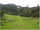 12
12 13
13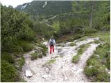 14
14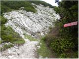 15
15 16
16 17
17 18
18 19
19 20
20 21
21 22
22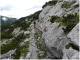 23
23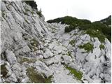 24
24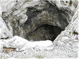 25
25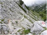 26
26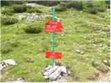 27
27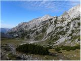 28
28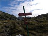 29
29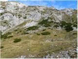 30
30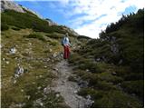 31
31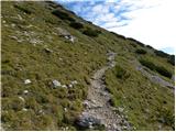 32
32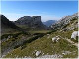 33
33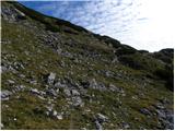 34
34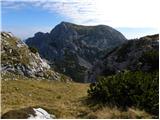 35
35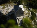 36
36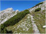 37
37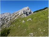 38
38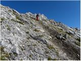 39
39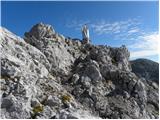 40
40 41
41
Discussion about the trail Planina Podvežak - Mala Ojstrica
|
| Peter-hribi29. 07. 2010 |
Pot s Planine Podvežak je zelo lepa, saj si hitro nad gozdno mejo (za več komentarjev glej Planina Podvežak - Kocbekov dom na Korošici). Pot s Sedelca se vzpenja po lepem travnatem pobočju in razgledi so lepi ... tudi iz vrha na Robanov kot in okolico.
Vsekakor je to zelo lep in nezahteven vrh!
|
|
|
|
| eka15. 06. 2011 |
Ali je sedaj še sneg na tej višini?
|
|
|
|
| petruša17. 06. 2011 |
S planine Podvežak ni več problema s snegom, tu pa tam še je iz Korošice na Ojstrico zaplate snega ki se ga da izogniti in na vrhu Ojstrice ga še je malo. Ni problema lahko greš brez problema, le varno in počasi.lp
|
|
|
|
| seinfeld12. 09. 2011 |
Pot smo opravili v soboto 10. septembra, dva odrasla, dva otroka 9 in 11 let. Z Male Ojstrice smo šli do Kocbekovega doma, na Planino Podvežak pa smo se vračali čez Prag, mimo Vodotočnega jezera, ter čez sedelce med Tolstim vrhom in Desko, kjer markacij ni, je pa pot dobro vidna. Vse skupaj je 13km poti, ki smo jo opravili v dobrih šestih urah. Pot je čudovita, razgibana, razgledna, ogromno kraških pojavov. Le čisto na vrhu Male Ojstrice se malo zatresejo noge(meni). Priporočam.
|
|
|
|
| gorskarozica19. 08. 2012 |
Te dni sem obiskala Vodotočnik, Ojstrico, Malo Ojstrico, Moličko peč. Sram je lahko tistega, ki je prišel na Malo Ojstrico in ukradel žig, ki je bil pritrjen na verigi. To ni planinec, ta oseba nima kaj delati v naših gorah. Žiga nima kaj rabiti, naredil pa je škodo PD in nam, planincem!  Sicer pa pot lepa, za kar poskrbijo naši markacisti. 
|
|
|
|
| Stamp1. 08. 2016 |
Da li se može bez problema na Malu Ojstricu popeti direktno sa istoka iz smjera Stare Kocbekove Koče i Crkve Cirila i Metoda ? hvala
|
|
|
|
| Stamp1. 08. 2016 |
Saznao na Forumu.. Može..
|
|
|
|
| golica4. 07. 2017 |
povprašujem za naslednje: iz Podvežaka nameravam na Veliki vrh,Zelenica...je potem markirana pot do Moličke peči(cerkvice) od V.vrha, oz Zelenice doli,nisem zasledila tega opisa,če lahko sestopiš,ker bi nadaljevala na malo Ojstrico in do Korošice.Hvala za info
|
|
|
|
| otiv4. 07. 2017 |
Odcep za Veliki vrh in Zelenico je s poti Podvežak - Molička peč, tako da se samo vrneš do odcepa in nadaljuješ v smeri kapelice in stare Kocbekove koče in od tam naprej na Malo Ojstrico in Ojstrico...
|
|
|
|
| golica4. 07. 2017 |
lepa hvala,ja to info sem želela. Pozdrav
|
|
|
|
| kr ena28. 09. 2017 |
je do planine podvežak lepa prevozna cesta?
|
|
|
|
| zlatica28. 09. 2017 |
Seveda, bila tam 7.9. lp
|
|
|
|
| kr ena28. 09. 2017 |
Kaksna je pot do male ojstrice, kaj snega?
|
|
|
|
| Blazz0914. 05. 2018 |
Včeraj smo se odpravili na to pot.
Cesta do izhodišča je v zelo dobrem stanju, mogoče na trenutke malo razrita zaradi gozdnih traktorjev. Začetek poti je zelo zahteven zaradi na stotine izpuljenih smrek. (verjetno neurje)
Snega je na trenutke še kar veliko tudi več kot 2m in se začne 300m nad pastirskimi kočami.
Vrha žal nismo dosegli ker si nismo upali prečiti strmine pred vzponom na Malo Ojstrico.
Sneg se topi neverjetno hitro, pot pa je zaradi snega po mojem mnenju zahtevna in nevarna.
|
|
|