 | Planina Jezerca - Kalški greben (via Dom na Krvavcu and Zvoh)
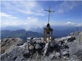
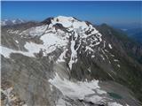
Kalški greben is 2224 m high and is the highest peak of the eponymous ridge. The summit, which has a registration box and a stamp, offers a beaut...
4 h 25 min |
 | Planina Ravne - Ojstrica (via Mala Ojstrica)
Ojstrica, named after its sharp shape, rises steeply above the Korošica River, the Logar Valley and Robanov Kot. From the top, where the registra...
4 h 15 min |
 | Planina Ravne - Ojstrica (via Dolga trata and Kocbekov dom)
Ojstrica, named after its sharp shape, rises steeply above the Korošica River, the Logar Valley and Robanov Kot. From the top, where the registra...
5 h 15 min |
| Planina Ravne - Ojstrica (via Dolga trata and Mala Ojstrica)
Ojstrica, named after its sharp shape, rises steeply above the Korošica River, the Logar Valley and Robanov Kot. From the top, where the registra...
4 h 45 min |
| Kraljev dol - Ojstrica (via Kocbekov dom)
Ojstrica, named after its sharp shape, rises steeply above the Korošica River, the Logar Valley and Robanov Kot. From the top, where the registra...
4 h 15 min |
 | Planina Podvežak - Planjava (via Srebrno sedlo)
Planjava is a small mountain range to the east of Kamnik saddle. It has two peaks, one eastern and one western. There is a marked trail to the ea...
4 h 15 min |
 | Planina Podvežak - Planjava (via Škarje)
Planjava is a small mountain range to the east of Kamnik saddle. It has two peaks, one eastern and one western. There is a marked trail to the ea...
4 h 45 min |
| Planina Ravne - Planjava (via Dolga trata and Srebrno sedlo)
Planjava is a small mountain range to the east of Kamnik saddle. It has two peaks, one eastern and one western. There is a marked trail to the ea...
5 h 30 min |
| Planina Ravne - Planjava (via Dolga trata and Škarje)
Planjava is a small mountain range to the east of Kamnik saddle. It has two peaks, one eastern and one western. There is a marked trail to the ea...
6 h |
 | Kraljev dol - Planjava (via Srebrno sedlo)
Planjava is a small mountain range to the east of Kamnik saddle. It has two peaks, one eastern and one western. There is a marked trail to the ea...
4 h 30 min |
 | Vršič - Planja
The summit is located between two Alpine valleys. On the northern side is the Mlinarica valley and on the southern side is the Zadnjica valley. F...
5 h 45 min |
 | End of road on Pokljuka - Begunjski vrh
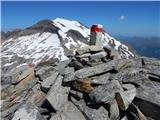
Begunjski vrh is a 2461 m high mountain located in the heart of the highest mountains in the Julian Alps. From the top, which has a registration ...
6 h 30 min |
 | end of road on Pokljuka - Triglavski dom na Kredarici
Triglavski dom na Kredarici is Slovenia's highest mountain hut. It is open all year round but only on an emergency basis out of season. From the ...
5 h |
| Rudno polje - Triglavski dom na Kredarici
Triglavski dom na Kredarici is Slovenia's highest mountain hut. It is open all year round but only on an emergency basis out of season. From the ...
5 h 20 min |
| Uskovnica (Razpotje) - Triglavski dom na Kredarici (via planina Spodnji Tosc)
Triglavski dom na Kredarici is Slovenia's highest mountain hut. It is open all year round but only on an emergency basis out of season. From the ...
5 h 30 min |
 | End of road on Pokljuka - Rjavina
Rjavina is located between two Alpine valleys. The two valleys are Kot and Krma. From the summit, which has a registration book, there is a very ...
7 h 30 min |
 | Plockenpass - Cima di Mezzo / Keller Warte (via Rifugio Marinelli)
The Cima di Mezzo (German: Keller Warte) is a 2713-metre-high mountain in Carnic Alps on the border between Austria and Itali. There is a small c...
4 h 35 min |
 | Plockenpass - Monte Coglians (Hohe Warte) (via Rifugio Marinelli)
At 2780 metres, Monte Coglians is the highest mountain in the Carnic Alps. From the top, where the cross and the bell stand, you have a very nice...
5 h |
| Rifugio Tolazzi - Monte Coglians (Hohe Warte) (via Rifugio Marinelli)
At 2780 metres, Monte Coglians is the highest mountain in the Carnic Alps. From the top, where the cross and the bell stand, you have a very nice...
4 h 25 min |
 | Alba di Canazei - Cima Ombretta (via Passo Ombretta)
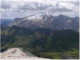
Cima Ombretta is a 3011-metre peak in the Marmolada mountain group. The summit on which the cross stands offers the best view of the nearby south...
5 h |
| Malga Ciapela - Cima Ombretta (via Passo Ombretta)
Cima Ombretta is a 3011-metre peak in the Marmolada mountain group. The summit on which the cross stands offers the best view of the nearby south...
4 h 40 min |
 | Lenzanger - Goldzechkopf
Goldzechkopf is a 3,042-metre peak in the Goldberg Mountain Group. The peak is located on the ridge between the better known Hoher Sonnblick and ...
5 h 10 min |
 | Rifugio Pederü - Lavarella
Lavarella (aka La Varella) is the second highest peak in the Lavarella mountain group. From the summit on which the cross stands, you have a very...
5 h |
 | Leibnitzbachbrücke - Hoher Prijakt
Hoher Prijakt is a 3,064-metre-high peak in the Schober Group. From the summit, which has a sign-in box, you have a very nice view over most of t...
4 h 15 min |
 | Gößgraben - Säuleck (Buderusweg)
Säuleck is a 3086m high peak in the High Tauern. From the summit, where the cross and the registration box are located, you can enjoy a beautiful...
5 h 30 min |
 | Lenzanger - Hoher Sonnblick
Hoher Sonnblick aka Rauriser Sonnblick is a 3106 metre high mountain in the Goldberg mountain group. The Zittelhaus hut and the highest meteorolo...
5 h |
 | Passo Campolongo - Cresta Strenta (Lichtenfels)
Cresta Strenta is a less prominent peak north of Piz Boe. The summit offers a very fine view over most of the Dolomites. At 3124 metres, Cresta S...
4 h 20 min |
 | Passo Gardena - Piz Boe
At 3152 metres, Piz Boe is the highest peak in the Sella mountain group in the Italian Dolomites. From the top, you have a beautiful view of the ...
5 h 50 min |
 | Passo Campolongo - Piz Boe (Lichtenfels)
At 3152 metres, Piz Boe is the highest peak in the Sella mountain group in the Italian Dolomites. From the top, you have a beautiful view of the ...
4 h 35 min |