Vrhnika-Tankovska cesta - Koča na Planini nad Vrhniko (Circular path Vrhnika-Planina-Lintvern-Vrhnika)
Starting point: Vrhnika-Tankovska cesta (300 m)
| Lat/Lon: | 45,9636°N 14,2752°E |
| |
Name of path: Circular path Vrhnika-Planina-Lintvern-Vrhnika
Time of walking: 2 h 20 min
Difficulty: easy marked way
Altitude difference: 433 m
Altitude difference po putu: 433 m
Map:
Recommended equipment (summer):
Recommended equipment (winter):
Views: 16.015
 | 3 people like this post |
Access to the starting point:
Coming from the Ljubljana direction, start on the Tankovska road, which you can reach by turning right at the last traffic light (bank, pharmacy. . . ). After driving straight ahead for about two kilometres, you will reach a dirt road, along which you park.
Path description:
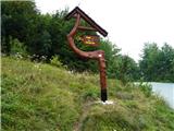
From the Tankov road, first along a narrow path, then a few hundred metres along the road to the houses on Storžev hill and we are at the old fruit drying kiln, where we continue along the middle path through dense hazel thickets, which offer plenty of shade in summer. Soon the path flattens out for a while and we are at the bench called "Zupanova". Here the path divides into a steeper right along Špica or a steeper but slightly longer left. Chose the right path, which climbs quickly along the ridge. It is no longer far to the top, but the path becomes a little steeper. At the top is an old lookout tower from 1955, which will soon be replaced by a new one. At the weekend, you can enjoy good home-coked food in the hut. We continue behind the hut down towards Lintvern, where the Bela stream rises. Follow the gorge down to the cottage in Stary malen, where there is a small water reservoir and a restored waterwheel from a former mill below. From here, continue along the road to the starting point, which is approximately 2 km away.

Pictures:
 1
1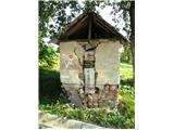 2
2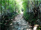 3
3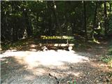 4
4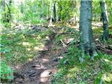 5
5 6
6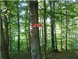 7
7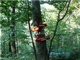 8
8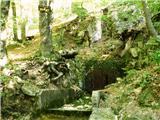 9
9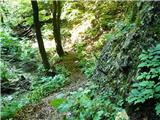 10
10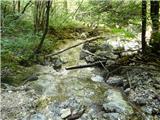 11
11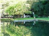 12
12 13
13 14
14
Discussion about the trail Vrhnika-Tankovska cesta - Koča na Planini nad Vrhniko (Circular path Vrhnika-Planina-Lintvern-Vrhnika)
|
| Guest18. 09. 2007 |
Super za nabiranje kondicije in obenem uživanje v prelepi naravi. Priporočam!
|
|
|
|
| andrej jerina9. 11. 2008 |
Danes smo po več kot pol let spet obiskali mojo "domačo" Planino. Začeli smo na tankovski cesti, pot je bila zaradi preteklih padavin mestoma mokra, blatna in spolzka, vendar je kljub temu šlo brez problemov. Na Planini smo se z otroki povzpeli na vrh novega stolpa in uživali v pogledu na Barje. Julijci in Kamniške Alpe so bile sicer v oblakih, vendar to ni skazilo našega lepega dne. Vzpon smo opravili mimo "Bukve", sestop pa čez "Špico". Priporoćam družinam z našimi najmlajšimi. LP Andrej
|
|
|
|
| lynx.attentus6. 10. 2013 |
Danes sva z bratom prehodila opisano krožno pot, le da sva jo prehodila v kontra smeri. Zelo lepo urejeno in dobro označeno. Le od Lintverna do koče na vrhu Planine malce bolj sopeš in grizeš kolena  Sicer pa je pot trenutno (6.10.2013) na nekaterih mestih nekoliko blatna in spolzka. Prehod skozi sotesko med Starim malnom in Lintvernom terja ob močnejših padavinah, višjem vodostaju potoka ali v snegu dober in trden korak. Vsekakor na nekaterih mestih je lahko poledenelo in ''dričavo''. Drugače pa lepa pot, večkrat prehojena. Le oblačen dan ni dopuščal razgleda z vrha obnovljenega stolpa. A to je že druga zgodba.
|
|
|