 | Topol - Tošč (direct way)
Tošč, which became the highest peak of Polhograjsko hribovje decades ago when Pasja ravan was lowered by 9 m by the Yugoslav army, is located nor...
2 h |
| Dom na Govejku - Tošč
Tošč, which became the highest peak of Polhograjsko hribovje decades ago when Pasja ravan was lowered by 9 m by the Yugoslav army, is located nor...
1 h 45 min |
 | Na Poklonu - Lubnik
Lubnik is a 1025 m high mountain rising steeply to the west of Škofja Loka. From the summit, on which the mountain lodge stands, you can enjoy a ...
2 h 15 min |
 | Mesnice - Krim (by road)
Krim is a 1107 m high mountain rising south of the Ljubljana Marshes. From the top of the mountain, where the mountain lodge and a number of tran...
1 h 50 min |
 | Rakitna - Krim
Krim is a 1107 m high mountain rising south of the Ljubljana Marshes. From the top of the mountain, where the mountain lodge and a number of tran...
2 h |
 | Polharski dom Krim - Krim
Krim is a 1107 m high mountain rising south of the Ljubljana Marshes. From the top of the mountain, where the mountain lodge and a number of tran...
1 h 35 min |
 | Brezje - Slivnica
Slivnica is a 1114 m high peak located north of Cerknica polje. The view from the summit, where the entry box is located, is rather limited due t...
2 h 15 min |
 | Selo - Pasja ravan (via Ostrež)
Pasja ravan is the second highest peak in the Polhograje Hills. A few decades ago, at 1029 m, it was the highest peak, but the Yugoslav army flat...
2 h 15 min |
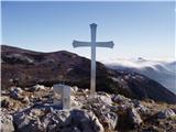 | Predmeja - Kucelj na Čavnu (by road)
Kucelj is located on the southern slopes of Trnovo Forest, north-west of the Vipava valley. From the uncultivated summit on which the cross stand...
1 h 45 min |
 | Predmeja - Kucelj na Čavnu
Kucelj is located on the southern slopes of Trnovo Forest, north-west of the Vipava valley. From the uncultivated summit on which the cross stand...
2 h |
 | Krnica - Kucelj na Čavnu (via Veliki Rob)
Kucelj is located on the southern slopes of Trnovo Forest, north-west of the Vipava valley. From the uncultivated summit on which the cross stand...
1 h 40 min |
 | Predmeja - Mali Modrasovec
Mali Modrasovec is a peak north of the house on Čavno in the Trnovo forest. On the top, surrounded by wods, there is a small house and a control ...
1 h 25 min |
 | Predmeja - Veliki Modrasovec
Veliki Modrasovec is located in the southern part of the Trnovo Forest near Predmeja. On the top of the hill is an old military building which yo...
1 h 35 min |
 | Lokve - Poldanovec
Poldanovec is located in Govce on the northern edge of Trnovo plateau. Govci are quickly rising above Gorenje Trebuše valley. Poldanovec is not t...
1 h 30 min |
 | Turški klanec - Mrzovec
Mrzovec is the most expressing peak in heart of Trnovo plateau. His position offers us great view, but is also limited with high trees. Thats why...
1 h 30 min |
 | Planinski dom Vrhe - Črni vrh (Čemšeniška planina)
Črni vrh is the highest peak of Čemšeniška mountain pasture and with a height of 1204 m it is the second highest peak in the Posavje - Zasavje hi...
1 h 30 min |
 | Kampelc - Javornik above Črni vrh
Javornik is a forested peak located southeast of Črnji Vrho. In 1972, a lookout tower was erected on the summit, which reaches above the treetops...
2 h 15 min |
 | Repna dolina - Javornik above Črni vrh
Javornik is a forested peak located southeast of Črnji Vrho. In 1972, a lookout tower was erected on the summit, which reaches above the treetops...
1 h 45 min |
 | Vodice (Mali Školj) - Javornik above Črni vrh
Javornik is a forested peak located southeast of Črnji Vrho. In 1972, a lookout tower was erected on the summit, which reaches above the treetops...
1 h 30 min |
 | Kalce - Veliki Javornik (Javorniki)
Veliki Javornik is a 1,268-metre-high peak in the forested hills called the Javorniki. The vast forests of the Javorniki stretch from Postojna to...
1 h 30 min |
 | Podlanišče - Bevkov vrh
Bevkov vrh, which is a point on the Slovenian mountain trail, is located between Cerkno and Spodnja Idrija. The summit is covered with forest and...
1 h 30 min |
 | Jazne (Lanišar) - Sivka
Sivka is a forested peak located west of Žiri and north of Idrija. On the summit there is a stamp of the Slovenian mountain trail and a registrat...
1 h 30 min |
 | Govejk - Sivka
Sivka is a forested peak located west of Žiri and north of Idrija. On the summit there is a stamp of the Slovenian mountain trail and a registrat...
1 h 40 min |
 | Zagreben (pri Dikcu) - Gozdnik
Gozdnik is a hill rising steeply above the village of Zabukovica. There is no view from the top, due to the forest, but there is a bivouac on it,...
1 h 30 min |
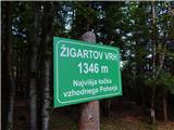 | Koča na Šumiku - Žigartov vrh
At 1346m, Žigartov vrh is the highest peak in the eastern part of Pohorje. An "observation" tower used to stand on the summit, but was erected on...
1 h 55 min |
 | Pohorje cable car - Žigartov vrh (via Razglednik)
At 1346m, Žigartov vrh is the highest peak in the eastern part of Pohorje. An "observation" tower used to stand on the summit, but was erected on...
2 h 15 min |
| Pohorje cable car - Žigartov vrh (via Mariborska koča)
At 1346m, Žigartov vrh is the highest peak in the eastern part of Pohorje. An "observation" tower used to stand on the summit, but was erected on...
2 h 20 min |
| Mariborska koča - Žigartov vrh
At 1346m, Žigartov vrh is the highest peak in the eastern part of Pohorje. An "observation" tower used to stand on the summit, but was erected on...
1 h 40 min |
 | Jurišče - Kršičevec
Kršičevec is a lesser known mountain located east of the village Jurišče in the Pivka Basin. From the grassy summit, where there is a registratio...
1 h 30 min |
 | Uglov laz - Koča na Kamnem griču (via Dom na Travni Gori)
The cottage is located on Kamný hill, a scenic peak rising south-west of Sodražica. The grassy summit, surrounded by forest, offers a beautiful v...
2 h |
 | Koča na Šumiku - Klopni vrh (eastern path)
Klopni vrh encloses the lower lying extensive plateau in the eastern Pohorje Mountains from the north-west. The area of the horizontal section at...
2 h |
 | Koča na Šumiku - Klopni vrh (northern path)
Klopni vrh encloses the lower lying extensive plateau in the eastern Pohorje Mountains from the north-west. The area of the horizontal section at...
2 h |
 | Dom planincev Farbanca - Tolsti vrh (Dobrovlje)
Tolsti vrh is, together with Šentjoški vrh (1077m), the highest peak of the Dobrovelj Plateau. The view from the summit, which has a registration...
2 h |
| Lipa - Tolsti vrh (Dobrovlje)
Tolsti vrh is, together with Šentjoški vrh (1077m), the highest peak of the Dobrovelj Plateau. The view from the summit, which has a registration...
1 h 40 min |
| Dom na Čreti - Tolsti vrh (Dobrovlje)
Tolsti vrh is, together with Šentjoški vrh (1077m), the highest peak of the Dobrovelj Plateau. The view from the summit, which has a registration...
1 h 45 min |
 | Zagrad - Medvižica (via Ostrič)
Medvižica is a rocky peak located on the Slovenian side of Čičaria. From the uncultivated summit you can enjoy a beautiful view of the surroundin...
1 h 45 min |
 | Črni Vrh - Čelkov vrh
Čelkov vrh is a 1106m high peak located to the south of Črni vrh. From the summit, which has a registration box and a stamp, there is a beautiful...
1 h 30 min |
 | Cenc - Špičasti vrh (on marked path)
Špičasti vrh is a forested mountain located south of the village of Zadlog. To ensure that the peak is not without a view, a 13m high wooden look...
1 h 30 min |
 | Podmeja - Sveta planina (Partizanski vrh)
Sveta planina, also Partizanski vrh, is a 1011 m high mountain located between Čemšeniška mountain pasture and Mrzlica. From the top, where a sma...
1 h 30 min |
 | Dom pod Reško planino - Sveta planina (Partizanski vrh)
Sveta planina, also Partizanski vrh, is a 1011 m high mountain located between Čemšeniška mountain pasture and Mrzlica. From the top, where a sma...
2 h 5 min |
 | Ravne - Cerk
At 1192 m, Cerk is the highest peak of Borovška Gora, a mountain range located between the Kolpa River valley and Goteniškje Snežnik. From the to...
1 h 30 min |
| Strma Reber - Cerk
At 1192 m, Cerk is the highest peak of Borovška Gora, a mountain range located between the Kolpa River valley and Goteniškje Snežnik. From the to...
1 h 45 min |
 | border crossing Remšnik - Kapunar / Kapunerkogel (via Sveti Urban)
Kapunar is a 1051 m high peak above Radlje ob Dravi. Just below the peak is an old caravan and border guardhouse, which is now used by radio amat...
2 h 20 min |
| border crossing Remšnik - Kapunar / Kapunerkogel (Austrian path)
Kapunar is a 1051 m high peak above Radlje ob Dravi. Just below the peak is an old caravan and border guardhouse, which is now used by radio amat...
2 h 5 min |
| Sv. Pankracij (Legat) / St. Pongratzen (Legat) - Kapunar / Kapunerkogel (via Sveti Urban)
Kapunar is a 1051 m high peak above Radlje ob Dravi. Just below the peak is an old caravan and border guardhouse, which is now used by radio amat...
2 h 10 min |
| Sv. Pankracij (Legat) / St. Pongratzen (Legat) - Kapunar / Kapunerkogel (Austrian path)
Kapunar is a 1051 m high peak above Radlje ob Dravi. Just below the peak is an old caravan and border guardhouse, which is now used by radio amat...
1 h 55 min |
 | Radeljski prelaz - Kapunar / Kapunerkogel
Kapunar is a 1051 m high peak above Radlje ob Dravi. Just below the peak is an old caravan and border guardhouse, which is now used by radio amat...
1 h 40 min |
| Sveti Jurij (Remšnik) - Kapunar / Kapunerkogel
Kapunar is a 1051 m high peak above Radlje ob Dravi. Just below the peak is an old caravan and border guardhouse, which is now used by radio amat...
2 h |
 | Solarji - Nagnoj
At 1193 m, Nagnoj is the second highest peak of the Kolovrat, a mountain range located between Tolmin and Venetian Slovenia. From the top, where ...
1 h 40 min |
 | Dom na Paškem Kozjaku - Štrukljev vrh
Štrukljev vrh is one of the three main peaks of Paški Kozjak, a 10 km long, narrow and very steep limestone mountain range between the Paka and H...
1 h 30 min |
 | Čemernica / Tschemernitzen - Arihova peč / Arichwand
Arihova peč is a scenic rock cliff located near the Blesščeče mountain pasture / Rossalm. There is a wooden hut at the top of the cliff and the c...
1 h 25 min |
 | St. John the Baptist on Ojstrica - Kozji vrh (at Košenjak)
Kozji vrh is a 1383-metre-high peak located above Pernice, and its height makes it the highest peak in the municipality of Muta....
1 h 35 min |
 | Široko - Veliki vrh (above Lom) (direct way)
Veliki vrh is located in the NE part of the Banjška plateau, rising above the Čepovan valley, the valley of the Soča River and the valley of the ...
1 h 30 min |
 | Široko - Veliki vrh (above Lom) (via Grudnica - on trail Lom is my home)
Veliki vrh is located in the NE part of the Banjška plateau, rising above the Čepovan valley, the valley of the Soča River and the valley of the ...
1 h 50 min |
 | Chortata - Egklouvi road - Stavrota (Lefkada)
Stavrota or Elati mountain is a 1182 m high mountain on the Greek island Lefkada. The island, which lies in Ionian sea, is also known as Lefkas o...
1 h 50 min |
 | Koča na Šumiku - Veliki vrh (on Pohorje)
Veliki vrh is a 1344-metre-high peak located above the RTC Jakec - Trije kralji ski resort. The highest point of the peak is located in the fores...
2 h |
 | Zelovo - Umac (pri Svilaji)
...
1 h 30 min |
 | Malovan - Čardak (Tremzina)
...
2 h |
 | Malovan - Oklinak
...
2 h 30 min |