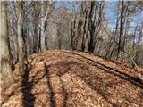
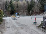
 | Stogovci (Vabča vas) - Kerješetov vrh
Kerješetov vrh is a 590-metre-high hill located above Jelovice. The hill is covered with forest, and the view is second to none....
1 h 30 min |
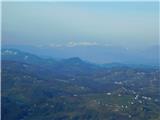
 | Za koridorjem - Sabotin (direct way)
Sabotin is hill above Nova Gorica or more accurate above Solkan. Altough its low attitude it is great outlook with sight to Julian Alps, river So...
1 h |
 | Za koridorjem - Sabotin (on ridge)
Sabotin is hill above Nova Gorica or more accurate above Solkan. Altough its low attitude it is great outlook with sight to Julian Alps, river So...
1 h 15 min |
 | Tremerje - Veliki Slomnik
Veliki Slomnik is a peak located between Košnica pri Celju and Liboje. There is no view from the summit, which has a registration box, due to the...
1 h |
 | Tremerje - Veliki Slomnik (Tremerje - Veliki Slomnik - Liboje)
Veliki Slomnik is a peak located between Košnica pri Celju and Liboje. There is no view from the summit, which has a registration box, due to the...
1 h 35 min |
 | Bridge over Dušica - Bajturn (Zaplaški hrib) (on north slope)
At 609 metres, Bajturn or Zaplaz Hill is the highest peak in the municipality of Trebnje. At the top there is a nice bench with a table, a box wi...
1 h 30 min |
| Okrog (Lazar) - Bajturn (Zaplaški hrib) (on ridge)
At 609 metres, Bajturn or Zaplaz Hill is the highest peak in the municipality of Trebnje. At the top there is a nice bench with a table, a box wi...
1 h 30 min |
 | Zgornje Poljčane - Rančka
...
1 h 25 min |
 | Podčetrtek (Terme Olimia) - Silavec (Stolp zdravja in veselja na Rudnici) (mimo gradu Podčetrtek)
...
1 h 35 min |
| Sveti Lovrenc (Podčetrtek) - Silavec (Stolp zdravja in veselja na Rudnici) (mimo gradu Podčetrtek)
...
1 h 25 min |
| Sveti Lovrenc (Podčetrtek) - Silavec (Stolp zdravja in veselja na Rudnici) (lažja pot)
...
1 h 15 min |
| Sveti Lovrenc (Podčetrtek) - Silavec (Stolp zdravja in veselja na Rudnici) (težja pot)
...
1 h 15 min |
 | Grgar - Frančiškov hrib
Frančiškov hrib is a less prominent peak located on Skalnica, whose highest peak is the 681-metre Sveta Gora. From the lookout peak, on which the...
1 h 15 min |
 | Povodje - Rašica (Vrh Staneta Kosca)
Vrh Staneta Kosca, better known as Rašica, is located north of Ljubljana, specifically above the village of Rašica and Dobena. From the top of th...
1 h 30 min |
 | Jablje Castle - Rašica (Vrh Staneta Kosca)
Vrh Staneta Kosca, better known as Rašica, is located north of Ljubljana, specifically above the village of Rašica and Dobena. From the top of th...
1 h 20 min |
| Loka - Rašica (Vrh Staneta Kosca)
Vrh Staneta Kosca, better known as Rašica, is located north of Ljubljana, specifically above the village of Rašica and Dobena. From the top of th...
1 h 20 min |
 | Rimske Toplice - Stražnik (via Borovo)
...
1 h 20 min |
 | Kozje - Raskože (Bohor) (via Vetrnik)
Raskože is a 650-metre-high peak in the eastern part of Bohor. Some also call this area Vetrnik. The south side of the peak is dominated by fores...
1 h 15 min |
 | Grgar - Vodice (via Ranjeke)
Vodice (according to some records also Sv. Jakob) is a peak located in the western part of the Banjška plateau. The summit, on which the mausoleu...
1 h 30 min |
 | Tacen - Šmarna gora (via Spodnja Kuhinja)
Šmarna gora is a 669 m high peak located north-west of the capital of Slovenia. The summit, which has a restaurant and a church, offers a beautif...
55 min |
 | Povodje - Šmarna gora
Šmarna gora is a 669 m high peak located north-west of the capital of Slovenia. The summit, which has a restaurant and a church, offers a beautif...
1 h 30 min |
 | Povodje - Šmarna gora (via Sedlo)
Šmarna gora is a 669 m high peak located north-west of the capital of Slovenia. The summit, which has a restaurant and a church, offers a beautif...
1 h 35 min |
| Šmartno - Šmarna gora (path around Šmarna gora)
Šmarna gora is a 669 m high peak located north-west of the capital of Slovenia. The summit, which has a restaurant and a church, offers a beautif...
1 h 30 min |
 | Vikrče - Šmarna gora (Mazijeva steza)
Šmarna gora is a 669 m high peak located north-west of the capital of Slovenia. The summit, which has a restaurant and a church, offers a beautif...
1 h 35 min |
 | Tacen - Šmarna gora (Partizanska steza)
Šmarna gora is a 669 m high peak located north-west of the capital of Slovenia. The summit, which has a restaurant and a church, offers a beautif...
1 h |
| Tacen (Sveti Jurij) - Šmarna gora (Romarska pot)
Šmarna gora is a 669 m high peak located north-west of the capital of Slovenia. The summit, which has a restaurant and a church, offers a beautif...
1 h |
| Tacen (Sveti Jurij) - Šmarna gora (Partizanska steza)
Šmarna gora is a 669 m high peak located north-west of the capital of Slovenia. The summit, which has a restaurant and a church, offers a beautif...
1 h |
 | Vikrče - Šmarna gora (Kovačeva steza)
Šmarna gora is a 669 m high peak located north-west of the capital of Slovenia. The summit, which has a restaurant and a church, offers a beautif...
1 h 10 min |
| Vikrče - Šmarna gora (learning trail)
Šmarna gora is a 669 m high peak located north-west of the capital of Slovenia. The summit, which has a restaurant and a church, offers a beautif...
1 h 20 min |
 | Šmartno - Grmada
Grmada is a 676 m high mountain located to the west of the much more visited Šmarna Gora. From the top, where there is a small airstrip, we have ...
55 min |
| Tacen - Grmada (via Spodnja Kuhinja)
Grmada is a 676 m high mountain located to the west of the much more visited Šmarna Gora. From the top, where there is a small airstrip, we have ...
1 h |
 | Vikrče - Grmada (via Zatrep)
Grmada is a 676 m high mountain located to the west of the much more visited Šmarna Gora. From the top, where there is a small airstrip, we have ...
1 h 15 min |
 | Vikrče - Grmada (Mazijeva steza)
Grmada is a 676 m high mountain located to the west of the much more visited Šmarna Gora. From the top, where there is a small airstrip, we have ...
1 h 5 min |
| Tacen - Grmada (Mazijeva steza)
Grmada is a 676 m high mountain located to the west of the much more visited Šmarna Gora. From the top, where there is a small airstrip, we have ...
1 h 10 min |
| Tacen (Sveti Jurij) - Grmada
Grmada is a 676 m high mountain located to the west of the much more visited Šmarna Gora. From the top, where there is a small airstrip, we have ...
1 h 5 min |
 | Vikrče - Grmada (Kovačeva steza)
Grmada is a 676 m high mountain located to the west of the much more visited Šmarna Gora. From the top, where there is a small airstrip, we have ...
1 h 10 min |
| Vikrče - Grmada (on Kovačeva steza and over Sedlo)
Grmada is a 676 m high mountain located to the west of the much more visited Šmarna Gora. From the top, where there is a small airstrip, we have ...
1 h 15 min |
| Vikrče - Grmada (learning trail)
Grmada is a 676 m high mountain located to the west of the much more visited Šmarna Gora. From the top, where there is a small airstrip, we have ...
1 h 20 min |
 | Seljanec - Ham (via Seljanečki potok)
Ham is a lonely peak in the Ivanščice mountains, above the Bednje valley. It is separated from Ivanščice by the valley of the Železnice stream, a...
1 h 30 min |
 | Skalnica - Sveta Gora (by road)
Sveta Gora is known mainly by the faithful and locals. Sveta Gora is a well-known pilgrimage centre above Nova Gorica. It is visited by believers...
1 h |
 | Skalnica - Sveta Gora (footpath)
Sveta Gora is known mainly by the faithful and locals. Sveta Gora is a well-known pilgrimage centre above Nova Gorica. It is visited by believers...
55 min |
 | Grgar - Sveta Gora (via Frančiškov hrib)
Sveta Gora is known mainly by the faithful and locals. Sveta Gora is a well-known pilgrimage centre above Nova Gorica. It is visited by believers...
1 h 25 min |
 | Grgar - Sveta Gora (via Po sredi)
Sveta Gora is known mainly by the faithful and locals. Sveta Gora is a well-known pilgrimage centre above Nova Gorica. It is visited by believers...
1 h 15 min |
| Grgar - Sveta Gora (via Ranjeke)
Sveta Gora is known mainly by the faithful and locals. Sveta Gora is a well-known pilgrimage centre above Nova Gorica. It is visited by believers...
1 h 30 min |
 | Grgar - Sveta Gora (via Križce)
Sveta Gora is known mainly by the faithful and locals. Sveta Gora is a well-known pilgrimage centre above Nova Gorica. It is visited by believers...
1 h 30 min |
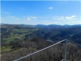
 | Šentjur - Resevna
Resevna is a peak located south of Šentjur. On the top is a 20m high lookout tower, which gives us a beautiful view of almost the whole of Sloven...
1 h 30 min |
| Jakob pri Šentjurju - Resevna
Resevna is a peak located south of Šentjur. On the top is a 20m high lookout tower, which gives us a beautiful view of almost the whole of Sloven...
1 h 30 min |
 | Hetinj / Hosszúhetény - Zengő (Mecsek) (pot rumeni trikotnik)
Zengő is the highest peak of the Mecsek Mountains in southern Hungary. At the top there is a huge lookout tower from which, despite its relativel...
1 h |
 | Brezno - Sveti Jurij (Remšnik) (along Remšniški potok)
The Church of St George is situated on a lookout point in the settlement Remšnik, which is on the slopes of Kozjak. Opposite the church, next to ...
1 h 35 min |
 | Zvodno - Bavč (via Suhi potok)
Bavč is a vegetated peak located south of Celje and Zvodno in Posavsko hribovje between Grmada and Srebotnik. On the way to the summit, we often ...
1 h 10 min |
 | Reka - Rodne
Rodne is a 698 m high peak located west of Orehovška Grape. From the top, which is covered with grass, we have a beautiful view towards the Cerkl...
1 h 20 min |
 | Štore - Srebotnik
Srebotnik is a lightly vegetated peak located south of Celje and Štore in the Posavje Hills. From the top, which has a registration box and a sma...
1 h 30 min |
 | Zvodno - Srebotnik (on Celje mountain trail)
Srebotnik is a lightly vegetated peak located south of Celje and Štore in the Posavje Hills. From the top, which has a registration box and a sma...
1 h 15 min |
 | Bresternica (Šoberjev dvor) - Tojzlov vrh
Tojzlov vrh is a forested hill located in the eastern part of Kozjak. On the top of the hill stands a small stone monument to the National Libera...
1 h 15 min |
 | Kozje - Pokojni vrh (Bohor) (via Vetrnik)
Pokojni vrh is in the eastern part of Bohor. The western part is pasture, the rest is mainly forest. There is no entry box. From the top there ar...
1 h 30 min |
 | Zagrad - Grmada above Celje (gentle path)
What Šmarna Gora is to the inhabitants of Ljubljana, Grmada is to the inhabitants of Celjá. The hut mountain of Celje is located south of the tow...
1 h 30 min |
 | Zvodno - Grmada above Celje (via Suhi potok)
What Šmarna Gora is to the inhabitants of Ljubljana, Grmada is to the inhabitants of Celjá. The hut mountain of Celje is located south of the tow...
1 h 15 min |
 | Blatni dol - Koča na Planini nad Vrhniko
Planina above Vrhnika is for hers inhabitants something like Šmarna gora for inhabitants of Ljubljana. It is 733 metres high and is reachable fro...
1 h 10 min |
 | Vrhnika - Koča na Planini nad Vrhniko (via bukev)
Planina above Vrhnika is for hers inhabitants something like Šmarna gora for inhabitants of Ljubljana. It is 733 metres high and is reachable fro...
1 h 5 min |
 | Vrhnika - Koča na Planini nad Vrhniko (via Špica)
Planina above Vrhnika is for hers inhabitants something like Šmarna gora for inhabitants of Ljubljana. It is 733 metres high and is reachable fro...
1 h |
 | Stara Vrhnika - Koča na Planini nad Vrhniko (via Kuren)
Planina above Vrhnika is for hers inhabitants something like Šmarna gora for inhabitants of Ljubljana. It is 733 metres high and is reachable fro...
1 h 15 min |
| Stara Vrhnika - Koča na Planini nad Vrhniko (via Špica)
Planina above Vrhnika is for hers inhabitants something like Šmarna gora for inhabitants of Ljubljana. It is 733 metres high and is reachable fro...
1 h 15 min |
 | Rečica ob Paki - Gora Oljka
Gora Oljka is a hill located east of Šmartno ob Paki. On the top stands the Church of the Holy Cross, which was built in the mid-18th century. Ju...
1 h 15 min |
 | Podgora - Gora Oljka (Martin way)
Gora Oljka is a hill located east of Šmartno ob Paki. On the top stands the Church of the Holy Cross, which was built in the mid-18th century. Ju...
1 h 20 min |
 | Radoboj - Sekolje (Strahinjčica)
Sekolje are the easternmost peak of Strahinjcica. It is visible as an interesting cone from the surrounding area. The view from the top is limite...
1 h 30 min |
 | Senožeti - Sveti Miklavž above Sava (footpath)
The Church of St Nicholas is situated on a hill south of Moravče. From the top you can enjoy a beautiful view of the nearby Limbarska gora, and t...
1 h 20 min |
 | Kamnica - Murovica
Murovica is a popular excursion point, accessible from the Posavina side, Domžale or from the Moravška valley. There is a bench and a registratio...
1 h 20 min |
 | Socka - Kozjek (nad Socko)
Kozjek) is an interesting peak, lying west of the ridge-like Kislica as a kind of pointed extension with precipitous walls on its western side. I...
1 h 10 min |
 | Hrastnik - Dom v Gorah
The mountain lodge in Gora is located east of Hrastnik, just a few metres below the 786m-high peak on which the Church of St George stands. From ...
1 h 30 min |
 | Spodnja Rečica - Tolsto
Tolsto is a 780 m high hill located between Huda Jama and Šmohor. There is no view from the top, where there is a registration box with a registr...
1 h 15 min |
 | Spodnja Rečica - Dom na Šmohorju (via Tolsto)
Dom na Šmohorju is located between Laško, Liboje and Zabukovica. From the house, or from the Church of St. Mohorj, a few minutes away, there is a...
1 h 35 min |
 | Liboje - Dom na Šmohorju (via organic farm Kralj)
Dom na Šmohorju is located between Laško, Liboje and Zabukovica. From the house, or from the Church of St. Mohorj, a few minutes away, there is a...
1 h 30 min |
 | Lesično - Brest (Bohor)
Brest is a peak on Bohor although it loks more like a saddle. It is an important intersection of the Bohor trails. It lies between Oslica, which ...
1 h 30 min |
 | Hayrack (Laška vas - Pečovje) - Tolsti vrh above Celjska koča (via chapel at Mary and on CPP)
Tolsti, according to some records also Tovsto vrh, is located above the Celjska koča ski resort. The summit, which has a registration box and a s...
1 h 35 min |
 | Zvodno - Tolsti vrh above Celjska koča (via Suhi potok)
Tolsti, according to some records also Tovsto vrh, is located above the Celjska koča ski resort. The summit, which has a registration box and a s...
1 h 30 min |
 | Zvodno - Tolsti vrh above Celjska koča (via Suhi potok and on ski slope)
Tolsti, according to some records also Tovsto vrh, is located above the Celjska koča ski resort. The summit, which has a registration box and a s...
1 h 30 min |
 | Senožeti - Cicelj
Cicelj is a forested peak located between Moravče and the village of Senožeti. There is no view from the top, which has a bench and a registratio...
1 h 30 min |
 | Senožeti - Cicelj (hunting path)
Cicelj is a forested peak located between Moravče and the village of Senožeti. There is no view from the top, which has a bench and a registratio...
1 h 30 min |
 | Renke - Ostrež
Ostrež is an 856 m high hill in the Posavje Hills. It rises south of the Sava River valley, above the main road Litija - Zagorje ob Savi....
1 h 30 min |
 | Source of Hubelj - Navrše
Navrše is a little-known peak located southeast of the Otliška Window. From the top there is a beautiful view of the Vipava valley and the peaks ...
1 h 35 min |
 | Braslovško jezero - Bezovec (Dobrovlje) (via hunting cottage)
Bezovec, also Brezovec on some maps, is an 857 m high peak located west of Braslov Lake, more precisely on the eastern part of the Dobrovlje plat...
1 h 30 min |
 | Braslovško jezero - Bezovec (Dobrovlje) (via Covnikov križ)
Bezovec, also Brezovec on some maps, is an 857 m high peak located west of Braslov Lake, more precisely on the eastern part of the Dobrovlje plat...
1 h 30 min |