Kapetanova bajta - Snežnik
Starting point: Kapetanova bajta (1460 m)
| Lat/Lon: | 45,5816°N 14,4313°E |
| |
Time of walking: 55 min
Difficulty: easy marked way
Altitude difference: 336 m
Altitude difference po putu: 336 m
Map: Snežnik 1:50.000
Recommended equipment (summer):
Recommended equipment (winter): ice axe, crampons
Views: 60.633
 | 6 people like this post |
Access to the starting point:
a) From Cerknica or Nová vas na Bloki, first drive to Bloška Police and from there continue in the direction of Loš and Babne Polje. At Pudob, turn right in the direction of Snežnik, Ilirska Bistrica, Knežak and the nearby settlement of Kozarišče. In Kozarišče, turn slightly left in the direction of Snežnik and follow the road in the direction of Snežnika at the following junctions. When Kozarišče ends, so does the asphalt, and we continue left in the direction of Mašun and Knežak, just after the bridge over the Malá Obrh. A long drive on a dirt road follows, and after about 19 km from Kozarišče we reach a crossroads where the road from Mašun joins from the right. Here, continue left in the direction of Sviščaki, which is about 10 km away on macadam, and at the crossroads follow the signs for Sviščaky. After approximately 29 km of dirt road, you will reach the Mountain Home at Sviščaki, after which at the crossroads continue left in the direction of Snežnika. Continue along the road, which also leads to the marked trail to Snežnik, and follow it for about 4 km, or until the marked footpath from Sviščaki joins from the right. Park in a suitable place at a marked crossroads.
b) Drive to Pivka, and from there continue to Knežak. In Knežak, at the marked crossroads, turn left towards Masun and the settlements Bač and Koritnicee. A little further on, go right in the direction of Masun and Koritnice (straight ahead Bač). After Koritnice the road starts to climb more visibly, and then after 18 km from the main crossroads in Knežak it leads to Masun, from where you continue driving right in the direction of Sviščaki, where you have about 12 km of dirt road to go. When you reach the Mountain Home at Sviščaki, continue for about 50 m towards Ilirska Bistrica, then turn left in the direction of Snežnika. Continue along the road, which is also the marked path to Snežnik, and follow it for about 4 km, or until the marked footpath from Sviščaky joins from the right. Park in a suitable place at a marked crossroads.
c) First drive to Ilirska Bistrica, then continue to Sviščaki (the turnoff is in the middle of Ilirska Bistrica and is marked, it may be a little less visible). Initially, the asphalt road is climbed, then after about 12 km of climbing, the asphalt is replaced by macadam. There are about 7 km of macadam, then you reach a junction near the Mountain Home at Sviščaki, where you turn right towards Snežnika. Continue along the road, which is also the marked trail to Snežnik, and follow it for about 4 km, or until the marked footpath from Sviščaky joins from the right. Park in a suitable place at a marked crossroads.
Path description:
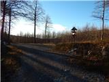
From the starting point, continue along the worse road, which soon leads us over the left serpentine, or from the starting point, continue to the left of the road, along the marked footpath, which joins the road after the serpentine. The road continues to climb crosswise along the increasingly scenic road, which offers beautiful views from Učka to Nanos, and, with good visibility, even further, all the way to the Dolomites. During the ascent, we can see in front of us the dwarf pines covered slope of Mali Snežnik and the interesting shorter south-western face of the above-mentioned peak. A little higher up, the path turns right and leads to the end of the road or a turning point.
From the end of the road, where there are a few benches, we have a nice view of Veliki Snežnik, and we continue along the wide marked path which continues through dwarf pines. The path then ascends to the right, and the views from the path get better and better, reaching over Gorski Kotar all the way to Velebit, with a good view of the Kvarner islands, Učka, etc. Higher up, the path enters an unmarked valley between the two Snežnik mountains, where the Matetova trail first branches off to the left, and higher up, we are joined from the right by the trail from Grda Draga and Mašun (both trails lead over Mali Snežnik).
At both crossroads, continue on the right path, and it takes about 5 minutes of cross-country climbing over a slightly steeper slope to reach the Shelter at Veliki Snežnik, where there is a greater risk of slipping in the snow.
When you reach the shelter, continue left in front of it and within a minute of further walking you will climb to the highest non-alpine peak in Slovenia, which offers views in all directions.
Description and pictures refer to the situation in 2015 (October).

Pictures:
 1
1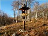 2
2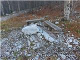 3
3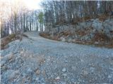 4
4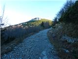 5
5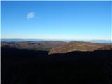 6
6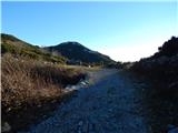 7
7 8
8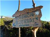 9
9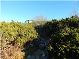 10
10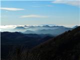 11
11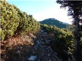 12
12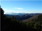 13
13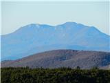 14
14 15
15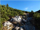 16
16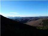 17
17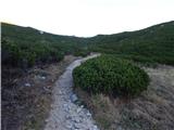 18
18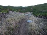 19
19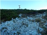 20
20 21
21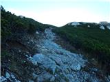 22
22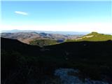 23
23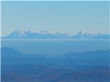 24
24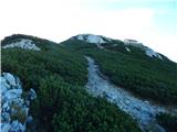 25
25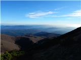 26
26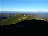 27
27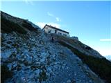 28
28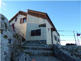 29
29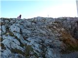 30
30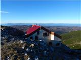 31
31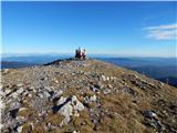 32
32 33
33
Discussion about the trail Kapetanova bajta - Snežnik
|
| Guest2. 01. 2007 |
Lepo vspenjajoča pot, sprva skozi gozd, nato pa skozi zasneženo pot obdano z nizkim grmičevjem nas popelje najprej do Malega, nato pa do Velikega Snežnika, s katerega je čudovit razgled na okoliške hribe. Na Veliki Snežnik sva šla 26.12.06, bil je lep sončen dan in veliko obiskovalcev. Pot na Snežnik je sicer res zasnežena, vendar sneg le pričara zimsko idilo količina snega pa ni tolikšna, da bi bile dereze nujno potrebne. Igor in Mateja
|
|
|
|
| AndrejaT18. 04. 2010 |
Ker je cesta trenutno še vedno pod snegom sva morala štartati od Sviščakov. Celotna pot je bila pokrita z južnim snegom zato je nujna nepremočljiva obutev in malce več truda za vzpon. Vreme je bilo lepo, le malce pod vrhom je močno pihalo. Razgledi so bili zelo lepi, vrhunec pa jota s klobaso in jabolčni štrudelj pri zelo prijaznih oskrbnikih v zavetišču pod vrhom  . Sigurne se poleti še vrneva. A&M
|
|
|
|
| andrej747. 05. 2011 |
Mogoče ni odveč pripomniti - za tiste ki pridejo sem prvič, da je najbolje priti do Sviščakov čez Ilirsko Bistrico. Pot je časovno hitrejša in bolj udobna :-)
|
|
|
|
| Robie19. 05. 2015 |
da, brez skrbi, pa še par zaplat snega je ob poti, drugače pa vode do kočeni ...
|
|
|
|
| modrook1227. 06. 2020 |
V sredo 25.6. smo po tej poti šli na Snežnik. Pravzaprav smo zaradi sečnje gozda avto parkirali 30 min nižje. Pot je bila ok. Videlo se je morje, to je pa tudi vse. Na drugi strani je bila megla.
|
|
|
|
| Pohodnica1314. 10. 2023 11:53:43 |
Pozor, danes malo pod Sviščaki ob makedamski cesti opažen precej velik medved.
|
|
|