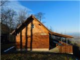
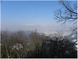
 | Lopata - Planinski dom Šentjungert
The mountain lodge is located just a few metres below the top of Gora, on which the Church of St Kunigunde, built in the 14th century, stands. Th...
1 h 30 min |
 | Zagorica pri Dobrniču - Lisec (Liška gora)
Lisec is a 565 m high peak located north to north-east of Žužemberk and south-west of Dobrnice. On the top of the peak stands a metal cross, to w...
1 h |
 | Gorica pri Slivnici - Rifnik
Rifnik is a 568m high peak located south of Šentjur near Celje. The summit, which is famous for its archaeological site, offers a beautiful view ...
1 h 15 min |
 | Podčetrtek (Terme Olimia) - Zavetišče Šmarnica na Mali Rudnici (mimo gradu Podčetrtek)
...
1 h 15 min |
| Sveti Lovrenc (Podčetrtek) - Zavetišče Šmarnica na Mali Rudnici (mimo gradu Podčetrtek)
...
1 h 5 min |
| Sveti Lovrenc (Podčetrtek) - Zavetišče Šmarnica na Mali Rudnici
...
1 h |
 | Trebnje Castle - Trebni vrh (via caves)
Trebni vrh is a 581-metre-high hill located south or south-west of Trebnje. On the top of the forested hill there is a bench, and near it there i...
50 min |
 | Trebnje Castle - Trebni vrh (steep path via hunting cottage)
Trebni vrh is a 581-metre-high hill located south or south-west of Trebnje. On the top of the forested hill there is a bench, and near it there i...
55 min |
| Trebnje Castle - Trebni vrh (via caves and hunting lodge)
Trebni vrh is a 581-metre-high hill located south or south-west of Trebnje. On the top of the forested hill there is a bench, and near it there i...
1 h |
 | Stogovci (Vabča vas) - Kerješetov vrh
Kerješetov vrh is a 590-metre-high hill located above Jelovice. The hill is covered with forest, and the view is second to none....
1 h 30 min |
 | Griže - Dragov dom na Homu (direct path)
Drago's home is located on a scenic hill, south of Šempeter. From the top, which is also the Church of St. Magdalene, there is a beautiful view f...
1 h 30 min |
| Šešče pri Preboldu - Dragov dom na Homu (via Lajnarjev hrib)
Drago's home is located on a scenic hill, south of Šempeter. From the top, which is also the Church of St. Magdalene, there is a beautiful view f...
1 h |
| Šešče pri Preboldu - Dragov dom na Homu (Brdovska pot)
Drago's home is located on a scenic hill, south of Šempeter. From the top, which is also the Church of St. Magdalene, there is a beautiful view f...
1 h 15 min |
 | Za koridorjem - Sabotin (direct way)
Sabotin is hill above Nova Gorica or more accurate above Solkan. Altough its low attitude it is great outlook with sight to Julian Alps, river So...
1 h |
 | Za koridorjem - Sabotin (on ridge)
Sabotin is hill above Nova Gorica or more accurate above Solkan. Altough its low attitude it is great outlook with sight to Julian Alps, river So...
1 h 15 min |
 | Tremerje - Veliki Slomnik
Veliki Slomnik is a peak located between Košnica pri Celju and Liboje. There is no view from the summit, which has a registration box, due to the...
1 h |
 | Bridge over Dušica - Bajturn (Zaplaški hrib) (on ridge)
At 609 metres, Bajturn or Zaplaz Hill is the highest peak in the municipality of Trebnje. At the top there is a nice bench with a table, a box wi...
1 h 20 min |
| Bridge over Dušica - Bajturn (Zaplaški hrib) (on north slope)
At 609 metres, Bajturn or Zaplaz Hill is the highest peak in the municipality of Trebnje. At the top there is a nice bench with a table, a box wi...
1 h 30 min |
| Okrog (Lazar) - Bajturn (Zaplaški hrib) (on ridge)
At 609 metres, Bajturn or Zaplaz Hill is the highest peak in the municipality of Trebnje. At the top there is a nice bench with a table, a box wi...
1 h 30 min |
 | Bad Gleichenberg (Sägewerk Weiss) - Stradner Kogel
Stradner Kogel is the highest hill in south-eastern Styria. The hill is of volcanic origin, and its vegetation prevents views in any direction. O...
1 h 15 min |
| Haag - Stradner Kogel
Stradner Kogel is the highest hill in south-eastern Styria. The hill is of volcanic origin, and its vegetation prevents views in any direction. O...
1 h 10 min |
 | Zgornje Poljčane - Rančka
...
1 h 25 min |
 | Sveti Lovrenc (Podčetrtek) - Silavec (Stolp zdravja in veselja na Rudnici) (mimo gradu Podčetrtek)
...
1 h 25 min |
| Sveti Lovrenc (Podčetrtek) - Silavec (Stolp zdravja in veselja na Rudnici) (lažja pot)
...
1 h 15 min |
| Sveti Lovrenc (Podčetrtek) - Silavec (Stolp zdravja in veselja na Rudnici) (težja pot)
...
1 h 15 min |
 | Grgar - Frančiškov hrib
Frančiškov hrib is a less prominent peak located on Skalnica, whose highest peak is the 681-metre Sveta Gora. From the lookout peak, on which the...
1 h 15 min |
 | Povodje - Rašica (Vrh Staneta Kosca)
Vrh Staneta Kosca, better known as Rašica, is located north of Ljubljana, specifically above the village of Rašica and Dobena. From the top of th...
1 h 30 min |
 | Jablje Castle - Rašica (Vrh Staneta Kosca)
Vrh Staneta Kosca, better known as Rašica, is located north of Ljubljana, specifically above the village of Rašica and Dobena. From the top of th...
1 h 20 min |
| Loka - Rašica (Vrh Staneta Kosca)
Vrh Staneta Kosca, better known as Rašica, is located north of Ljubljana, specifically above the village of Rašica and Dobena. From the top of th...
1 h 20 min |
 | Kekec - Škabrijel
Škabrijel is an peak north-east of the town of Gorizia. Since the vegetation has been cleared and a tall metal lookout tower erected at the top, ...
50 min |
 | Prevala - Škabrijel (via Veliki hrib)
Škabrijel is an peak north-east of the town of Gorizia. Since the vegetation has been cleared and a tall metal lookout tower erected at the top, ...
1 h 5 min |
| Prevala - Škabrijel
Škabrijel is an peak north-east of the town of Gorizia. Since the vegetation has been cleared and a tall metal lookout tower erected at the top, ...
50 min |
| Prevala - Škabrijel (via Hungarian pyramid)
Škabrijel is an peak north-east of the town of Gorizia. Since the vegetation has been cleared and a tall metal lookout tower erected at the top, ...
1 h |
 | Rimske Toplice - Stražnik (via Borovo)
...
1 h 20 min |
 | Kozje - Raskože (Bohor) (via Vetrnik)
Raskože is a 650-metre-high peak in the eastern part of Bohor. Some also call this area Vetrnik. The south side of the peak is dominated by fores...
1 h 15 min |
 | Grgar - Vodice (via Ranjeke)
Vodice (according to some records also Sv. Jakob) is a peak located in the western part of the Banjška plateau. The summit, on which the mausoleu...
1 h 30 min |
 | Šmartno - Šmarna gora (Šmartinska way)
Šmarna gora is a 669 m high peak located north-west of the capital of Slovenia. The summit, which has a restaurant and a church, offers a beautif...
50 min |
 | Tacen - Šmarna gora (via Spodnja Kuhinja)
Šmarna gora is a 669 m high peak located north-west of the capital of Slovenia. The summit, which has a restaurant and a church, offers a beautif...
55 min |
 | Povodje - Šmarna gora
Šmarna gora is a 669 m high peak located north-west of the capital of Slovenia. The summit, which has a restaurant and a church, offers a beautif...
1 h 30 min |
 | Šmartno - Šmarna gora (path around Šmarna gora)
Šmarna gora is a 669 m high peak located north-west of the capital of Slovenia. The summit, which has a restaurant and a church, offers a beautif...
1 h 30 min |
 | Vikrče - Šmarna gora (via Zatrep)
Šmarna gora is a 669 m high peak located north-west of the capital of Slovenia. The summit, which has a restaurant and a church, offers a beautif...
1 h 10 min |
 | Tacen - Šmarna gora (Partizanska steza)
Šmarna gora is a 669 m high peak located north-west of the capital of Slovenia. The summit, which has a restaurant and a church, offers a beautif...
1 h |
| Tacen (Sveti Jurij) - Šmarna gora (Romarska pot)
Šmarna gora is a 669 m high peak located north-west of the capital of Slovenia. The summit, which has a restaurant and a church, offers a beautif...
1 h |
| Tacen (Sveti Jurij) - Šmarna gora (Partizanska steza)
Šmarna gora is a 669 m high peak located north-west of the capital of Slovenia. The summit, which has a restaurant and a church, offers a beautif...
1 h |
 | Vikrče - Šmarna gora (Kovačeva steza)
Šmarna gora is a 669 m high peak located north-west of the capital of Slovenia. The summit, which has a restaurant and a church, offers a beautif...
1 h 10 min |
| Vikrče - Šmarna gora (learning trail)
Šmarna gora is a 669 m high peak located north-west of the capital of Slovenia. The summit, which has a restaurant and a church, offers a beautif...
1 h 20 min |
 | Šmartno - Grmada
Grmada is a 676 m high mountain located to the west of the much more visited Šmarna Gora. From the top, where there is a small airstrip, we have ...
55 min |
| Tacen - Grmada (via Spodnja Kuhinja)
Grmada is a 676 m high mountain located to the west of the much more visited Šmarna Gora. From the top, where there is a small airstrip, we have ...
1 h |
 | Vikrče - Grmada (via Zatrep)
Grmada is a 676 m high mountain located to the west of the much more visited Šmarna Gora. From the top, where there is a small airstrip, we have ...
1 h 15 min |
 | Vikrče - Grmada (Mazijeva steza)
Grmada is a 676 m high mountain located to the west of the much more visited Šmarna Gora. From the top, where there is a small airstrip, we have ...
1 h 5 min |
| Tacen - Grmada (Mazijeva steza)
Grmada is a 676 m high mountain located to the west of the much more visited Šmarna Gora. From the top, where there is a small airstrip, we have ...
1 h 10 min |
| Tacen (Sveti Jurij) - Grmada
Grmada is a 676 m high mountain located to the west of the much more visited Šmarna Gora. From the top, where there is a small airstrip, we have ...
1 h 5 min |
 | Vikrče - Grmada (Kovačeva steza)
Grmada is a 676 m high mountain located to the west of the much more visited Šmarna Gora. From the top, where there is a small airstrip, we have ...
1 h 10 min |
| Vikrče - Grmada (on Kovačeva steza and over Sedlo)
Grmada is a 676 m high mountain located to the west of the much more visited Šmarna Gora. From the top, where there is a small airstrip, we have ...
1 h 15 min |
| Vikrče - Grmada (learning trail)
Grmada is a 676 m high mountain located to the west of the much more visited Šmarna Gora. From the top, where there is a small airstrip, we have ...
1 h 20 min |
 | Seljanec - Ham (via Seljanečki potok)
Ham is a lonely peak in the Ivanščice mountains, above the Bednje valley. It is separated from Ivanščice by the valley of the Železnice stream, a...
1 h 30 min |
 | Skalnica - Sveta Gora (by road)
Sveta Gora is known mainly by the faithful and locals. Sveta Gora is a well-known pilgrimage centre above Nova Gorica. It is visited by believers...
1 h |
 | Skalnica - Sveta Gora (footpath)
Sveta Gora is known mainly by the faithful and locals. Sveta Gora is a well-known pilgrimage centre above Nova Gorica. It is visited by believers...
55 min |
 | Grgar - Sveta Gora (via Frančiškov hrib)
Sveta Gora is known mainly by the faithful and locals. Sveta Gora is a well-known pilgrimage centre above Nova Gorica. It is visited by believers...
1 h 25 min |
 | Grgar - Sveta Gora (via Po sredi)
Sveta Gora is known mainly by the faithful and locals. Sveta Gora is a well-known pilgrimage centre above Nova Gorica. It is visited by believers...
1 h 15 min |
| Grgar - Sveta Gora (via Ranjeke)
Sveta Gora is known mainly by the faithful and locals. Sveta Gora is a well-known pilgrimage centre above Nova Gorica. It is visited by believers...
1 h 30 min |
 | Grgar - Sveta Gora (via Križce)
Sveta Gora is known mainly by the faithful and locals. Sveta Gora is a well-known pilgrimage centre above Nova Gorica. It is visited by believers...
1 h 30 min |
 | Šentjur - Resevna
Resevna is a peak located south of Šentjur. On the top is a 20m high lookout tower, which gives us a beautiful view of almost the whole of Sloven...
1 h 30 min |
| Jakob pri Šentjurju - Resevna
Resevna is a peak located south of Šentjur. On the top is a 20m high lookout tower, which gives us a beautiful view of almost the whole of Sloven...
1 h 30 min |
 | Hetinj / Hosszúhetény - Zengő (Mecsek) (pot rumeni trikotnik)
Zengő is the highest peak of the Mecsek Mountains in southern Hungary. At the top there is a huge lookout tower from which, despite its relativel...
1 h |
 | Reka - Rodne
Rodne is a 698 m high peak located west of Orehovška Grape. From the top, which is covered with grass, we have a beautiful view towards the Cerkl...
1 h 20 min |
 | Štore - Srebotnik
Srebotnik is a lightly vegetated peak located south of Celje and Štore in the Posavje Hills. From the top, which has a registration box and a sma...
1 h 30 min |
 | Zvodno - Srebotnik (on Celje mountain trail)
Srebotnik is a lightly vegetated peak located south of Celje and Štore in the Posavje Hills. From the top, which has a registration box and a sma...
1 h 15 min |
 | Bresternica (Šoberjev dvor) - Tojzlov vrh
Tojzlov vrh is a forested hill located in the eastern part of Kozjak. On the top of the hill stands a small stone monument to the National Libera...
1 h 15 min |
 | Kozje - Pokojni vrh (Bohor) (via Vetrnik)
Pokojni vrh is in the eastern part of Bohor. The western part is pasture, the rest is mainly forest. There is no entry box. From the top there ar...
1 h 30 min |
 | Zagrad - Grmada above Celje (gentle path)
What Šmarna Gora is to the inhabitants of Ljubljana, Grmada is to the inhabitants of Celjá. The hut mountain of Celje is located south of the tow...
1 h 30 min |
 | Blatni dol - Koča na Planini nad Vrhniko
Planina above Vrhnika is for hers inhabitants something like Šmarna gora for inhabitants of Ljubljana. It is 733 metres high and is reachable fro...
1 h 10 min |
 | Vrhnika - Koča na Planini nad Vrhniko (via bukev)
Planina above Vrhnika is for hers inhabitants something like Šmarna gora for inhabitants of Ljubljana. It is 733 metres high and is reachable fro...
1 h 5 min |
 | Vrhnika - Koča na Planini nad Vrhniko (via Špica)
Planina above Vrhnika is for hers inhabitants something like Šmarna gora for inhabitants of Ljubljana. It is 733 metres high and is reachable fro...
1 h |
 | Stara Vrhnika - Koča na Planini nad Vrhniko (via Kuren)
Planina above Vrhnika is for hers inhabitants something like Šmarna gora for inhabitants of Ljubljana. It is 733 metres high and is reachable fro...
1 h 15 min |
| Stara Vrhnika - Koča na Planini nad Vrhniko (via Špica)
Planina above Vrhnika is for hers inhabitants something like Šmarna gora for inhabitants of Ljubljana. It is 733 metres high and is reachable fro...
1 h 15 min |
 | Rečica ob Paki - Gora Oljka
Gora Oljka is a hill located east of Šmartno ob Paki. On the top stands the Church of the Holy Cross, which was built in the mid-18th century. Ju...
1 h 15 min |
 | Podgora - Gora Oljka (Martin way)
Gora Oljka is a hill located east of Šmartno ob Paki. On the top stands the Church of the Holy Cross, which was built in the mid-18th century. Ju...
1 h 20 min |
 | Gradišče - Škavnica
Škavnica is a 734-metre-high peak above Vipava. From the top of the peak, where a small cross and a bench stand, you can enjoy a very nice view o...
1 h 15 min |
 | Radoboj - Sekolje (Strahinjčica)
Sekolje are the easternmost peak of Strahinjcica. It is visible as an interesting cone from the surrounding area. The view from the top is limite...
1 h 30 min |
 | Senožeti - Sveti Miklavž above Sava (footpath)
The Church of St Nicholas is situated on a hill south of Moravče. From the top you can enjoy a beautiful view of the nearby Limbarska gora, and t...
1 h 20 min |
 | Kamnica - Murovica
Murovica is a popular excursion point, accessible from the Posavina side, Domžale or from the Moravška valley. There is a bench and a registratio...
1 h 20 min |
 | Socka - Kozjek (nad Socko)
Kozjek) is an interesting peak, lying west of the ridge-like Kislica as a kind of pointed extension with precipitous walls on its western side. I...
1 h 10 min |
 | Center Vintgar - Lookout point at Ančnikovo gradišče (via Bistriški vintgar)
The viewing platform is located close to Ančnik's hillfort. The platform offers a beautiful view. We can see the place Slovenska Bistrica and it...
1 h 30 min |
 | Hrastnik - Dom v Gorah
The mountain lodge in Gora is located east of Hrastnik, just a few metres below the 786m-high peak on which the Church of St George stands. From ...
1 h 30 min |
 | Gabrje - Jeterbenk
Jeterbenk is a 774 m high peak located between Slavko's home at Gole Brdo and Katarina (Topol village). From the top, where there is a large cros...
1 h 30 min |
 | Spodnja Rečica - Tolsto
Tolsto is a 780 m high hill located between Huda Jama and Šmohor. There is no view from the top, where there is a registration box with a registr...
1 h 15 min |
 | Liboje - Dom na Šmohorju (via organic farm Kralj)
Dom na Šmohorju is located between Laško, Liboje and Zabukovica. From the house, or from the Church of St. Mohorj, a few minutes away, there is a...
1 h 30 min |
 | Gabrje - Rog
The Rog is a 798 m high peak located above the village of Topole, just 10 minutes from St Catherine's Church. From the top of the hill, where a l...
1 h 20 min |
 | Gabrje - Sveti Jakob
The Church of St James is located on a hill north of the village of Topol near Medvode. From the top, where there is a registration box with a st...
1 h 30 min |
 | Lesično - Brest (Bohor)
Brest is a peak on Bohor although it loks more like a saddle. It is an important intersection of the Bohor trails. It lies between Oslica, which ...
1 h 30 min |