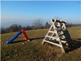
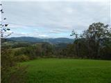
 | Pečar - Žagarski vrh
Žagarski vrh is located in the ridge between Podlipoglav and Besnica. From the top of the peak, on which stands the Home of Radio Amateurs, we ha...
35 min |
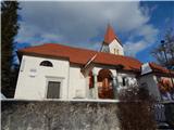
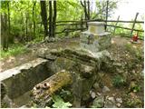
 | Preddvor - Novi grad (Pusti grad)
Novi grad, or Pusti grad, in German Neuburg, was first mentioned in 1156. Today, only ruins remain of the castle, which is located on a hill nort...
40 min |
 | Železna vrata - Trstelj
Trstelj is the highest peak in the Black Hills ridge. The view from the vast summit, where the TV transmitters stand, is split in half. From the ...
35 min |
 | Jezersko polje - Peč (viewpoint)
The viewpoint is located 50 metres lower than the 720-metre-high Peči, the peak that separates the Lower Bohinj Valley from the Upper Bohinj Vall...
35 min |
 | Sveta Gora - Vodice
Vodice (according to some records also Sv. Jakob) is a peak located in the western part of the Banjška plateau. The summit, on which the mausoleu...
45 min |
 | Veliko Trebeljevo - Sveta Marjeta (Prežganje)
The Church of St Marjeta is located on top of a hill above Prežganj. Next to the church is the Minorite House of Spiritual Exercises, and a littl...
40 min |
 | Grozzana / Gročana - Kokoš
Koča na Kokoši is located at the top of Jirmanec, just 5 minutes away from the forested Kokoša. The summit, located south of the Lokavsko polje a...
40 min |
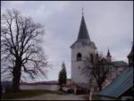
 | Tržič - Sveti Jurij above Tržič
The Church of St George, built in the 15th century, is situated on a small hill above Tržič or Bistrica near Tržič. The first Bishop of Ljubljana...
40 min |
 | Travnarjev gozd (Hotenjsko podolje) - Sveta Barbara (Ravnik pri Hotedršici)
The Church of St Barbara is situated on a hill overloking the village of Ravnik near Hotedršice. From the church or its immediate surroundings, w...
35 min |
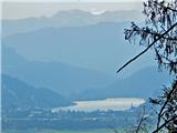
 | Velika Zaka (Bled) - Mala Osojnica (along Ojstrica)
Mala Osojnica is a 691 m high peak rising above Lake Bled near Velika Zaka. It is a favourite spot for photographers, as all the famous panoramas...
40 min |
 | Praproče - Mali vrh
To the west of Polhov Gradec, between the rivers Mala voda and Velika Božna, is a 708-metre-high hill called Mali vrh. From the grassy summit, wh...
35 min |
 | Kuren - Koča na Planini nad Vrhniko
Planina above Vrhnika is for hers inhabitants something like Šmarna gora for inhabitants of Ljubljana. It is 733 metres high and is reachable fro...
45 min |
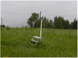
 | Možjanca - Apnišče
Apnišče is a 740 m high mountain located between Možjanca and Štefanja gora. It is the highest point of the Šenčur municipality. There is a bench...
35 min |
 | Križevska vas - Murovica (circular path)
Murovica is a popular excursion point, accessible from the Posavina side, Domžale or from the Moravška valley. There is a bench and a registratio...
50 min |
 | Sveta Trojica - Murovica
Murovica is a popular excursion point, accessible from the Posavina side, Domžale or from the Moravška valley. There is a bench and a registratio...
45 min |
 | Križevska vas - Murovica
Murovica is a popular excursion point, accessible from the Posavina side, Domžale or from the Moravška valley. There is a bench and a registratio...
45 min |
 | Blečji vrh - Kucelj
Kucelj is a 748m high peak located north of Višnja gora. From the top of the peak there is a small geodetic tower with a stamp, which offers a be...
45 min |
| Veliko Trebeljevo - Kucelj
Kucelj is a 748m high peak located north of Višnja gora. From the top of the peak there is a small geodetic tower with a stamp, which offers a be...
45 min |
 | Zagorje - Šilentabor
Šilentabor is a 751 m high peak located just above the village of the same name. From the top, near which there is also a bench and a registratio...
35 min |
 | Ortnek - Ortnek Castle
Ortnek Castle is located on the Veliki Žrnovec escarpment, which rises south-west of the village of Ortnek. Today, only ruins remain of the castl...
40 min |
 | Smiljan - Krčmar (po markirani poti)
...
40 min |
 | Topol - Jeterbenk
Jeterbenk is a 774 m high peak located between Slavko's home at Gole Brdo and Katarina (Topol village). From the top, where there is a large cros...
45 min |
 | Škalske Cirkovce - Lubela (by road)
Lubela is a hill at Velenje, rising north above the Šaleška dolina and belonging to the Šentviška hills or the wider area of the Graška Gora.On t...
45 min |
 | Škalske Cirkovce - Skalni vrh (Vodemla)
Skalni vrh is the highest peak of Vodemla Hill, rising above Paka pri Velenju on one side and the Velenje basin on the other. On the way along th...
35 min |
 | Dule - Kamen vrh
Kamen vrh is a scenic peak located on the northern outskirts of Mala Gora. From the top, surrounded by low bushes, there is a beautiful view of p...
45 min |
 | Mislinja - Črepič
Črepič is a 798 m high peak located to the west of Mislinja. As the summit is forested, there is no view from the summit, but it is so extensive ...
45 min |
 | Črne njive - Ahac
Ahac or St. Ahac is a 799 m high peak located east of Ilirska Bistrica. The summit, which is home to a registration box, a cross and the ruins of...
40 min |
 | Zaplana (St. Urh and St. Martin) - Ulovka
Ulovka is the peak between Zaplana and the Shelter at Mountain pasture above Vrhnika. From the top, which is reached by ski lifts, there is a nic...
50 min |
 | Topol - Sveti Jakob
The Church of St James is located on a hill north of the village of Topol near Medvode. From the top, where there is a registration box with a st...
40 min |
| Topol - Sveti Jakob (via homestead Na Vihri)
The Church of St James is located on a hill north of the village of Topol near Medvode. From the top, where there is a registration box with a st...
45 min |
 | Hunting sports association Vinska Gora - Vinska gora
Vinska gora, marked on some maps as neighbouring Temnjak, is an 806 m high hill located north-west of Dobrnež and north-east of Vinská Gora. The ...
40 min |
 | Belo - Goljek
Goljek is an 809 m high peak located east of Polhograjska Grmada. The view from the summit, which is home to the remains of a former watchtower o...
40 min |
 | Srednje - Globočak
Globočak is an 809 m high peak located in the Kanalski Kolovrat mountain range. The summit, which contains some remnants of the First World War, ...
35 min |
 | Križna Gora - Archangel Gabriel (Planica)
Planica is an 824 m high peak located north of Škofja Loka, between Krizna Gora and Planica. From the top, where the Church of St. Gabriel the Ar...
35 min |
 | Čepulje - Archangel Gabriel (Planica)
Planica is an 824 m high peak located north of Škofja Loka, between Krizna Gora and Planica. From the top, where the Church of St. Gabriel the Ar...
50 min |
 | Zapotok - Kurešček
Kurešček is an 826 m high peak located south of Ig and south-west of Želimlje. The view from the top, on which the church stands, is not possible...
45 min |
 | Čepulje - Špičasti hrib
Špičasti hrib (Špičasti vrh on maps) is an 837 m high peak located to the west of Sveti Jošto above Kranj. There is no view from the top, which h...
40 min |
 | Javornik - Sveti Jošt above Kranj
Sveti Jošt above Kranj, is a hill located to the west of the slightly lower Šmarjetna Gora. From the top, where the Church of St. Jošto and the J...
40 min |
| Čepulje - Sveti Jošt above Kranj
Sveti Jošt above Kranj, is a hill located to the west of the slightly lower Šmarjetna Gora. From the top, where the Church of St. Jošto and the J...
45 min |
 | Rovišče - Zasavska Sveta gora (by road)
Zasavska Sveta gora is a popular excursion point located between Litija and Izlaki. From the top, where the parish church of the Nativity of the ...
35 min |
 | Križna jama - Križna gora
Križna gora is a partially overloked peak located above the village of Sveta Ana and Podlož. From the top of the hill on which the Church of the ...
35 min |
| Stružnica - Kuželjska stena
Kuželjska stena rises majestically above the village of Kuželj in the Kolpa valley. It is a rise in a fault that winds above the upper Kolpa vall...
45 min |
 | Poljana (Završnica) - Mali vrh above Završnica
Mali vrh, which measures 863 metres, is one of the peaks of the Breznik Peci (also Reber) ridge, with the Zavrh valley to the north and the upper...
35 min |
 | Smrečje - Vrh Svetih Treh Kraljev (by road)
The Church of the Holy Three Kings is situated on a lookout above the village of Vrh Svetih Treh kraljev. From the top, which has an observation ...
45 min |
 | Smrečje - Vrh Svetih Treh Kraljev (footpath)
The Church of the Holy Three Kings is situated on a lookout above the village of Vrh Svetih Treh kraljev. From the top, which has an observation ...
40 min |
| Smrečje - Vrh Svetih Treh Kraljev (via Jereb)
The Church of the Holy Three Kings is situated on a lookout above the village of Vrh Svetih Treh kraljev. From the top, which has an observation ...
45 min |
| Račevsko jezero - Vrh Svetih Treh Kraljev
The Church of the Holy Three Kings is situated on a lookout above the village of Vrh Svetih Treh kraljev. From the top, which has an observation ...
45 min |
 | Smrečje - Lavrovec
Lavrovec is an 890 m high peak located between Horjul and Žirmi. From the top, where the solar irradiance meter is located (official measuring po...
40 min |
 | Dom na Govejku - Gontarska planina
Gontarska planina is an 894 m high mountain located between Osolnik and Tosce. From the top, where there are two benches, we have a beautiful vie...
35 min |
 | Planinski dom pod Ježo - Očna
Očna is a 906 m high peak located in the Kolovrat mountain range, west of Tolmina. From the meadow a few metres away from the summit, we have a b...
55 min |