Renke - Climbing area and ferrata Renke (panoramic path on ferrata to Spital)
Starting point: Renke (231 m)
Name of path: panoramic path on ferrata to Spital
Time of walking: 2 h
Difficulty: very difficult marked way
Altitude difference: 469 m
Altitude difference po putu: 470 m
Map: Zagorje ob Savi, turistična karta 1:30.000
Recommended equipment (summer): helmet, self belay set
Recommended equipment (winter): helmet, self belay set, crampons
Views: 16.610
 | 4 people like this post |
Access to the starting point:
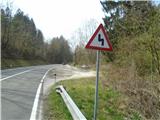
From Ljubljana via Litija (45 km), or from Zagorje towards Ljubljana (6 km), take the main Zasavje road to the small village of Renke, and park along the Sava River in a more or less untidy parking lot, just in front of the suspension bridge over the Sava River (which is only for pedestrians and is not in the best condition at the moment). The climbing area and the ferrata are situated above the left bank of the Sava River, so you have to walk from the parking lot over the bridge over the river to the opposite bank.
Path description:
We start our journey with a touch of adrenaline on the footbridge of the suspension bridge over the Sava (officially it has a sign that it is closed), but otherwise it is used by railwaymen, mountaineers, climbers, hunters, kayakers, rafters, etc. At the end of the bridge, we turn left (get used to the directional green markings) and continue for about 50-80 m right next to the railway up (in the direction towards Ljubljana), and then we have to cross over the railway line and up the bank of the Sava River (in the direction of Ljubljana). The same path or crossing is also used by locals who live in the house above the railway opposite the bridge. Then follow the well-trodden and marked mountain path towards Zasavska sv. Gora, which climbs gently at first and then more steeply up through the forest towards the west. After about 15-20 minutes of walking, behind a large fallen beech tree, when you see the first rock walls on the right above the path, turn right off the marked path (marked with a green sign and an arrow) in the direction of the climbing area. Continue almost horizontally to the east, passing a small rock peak, and then the path begins to climb again towards the first rock sector of the climbing area, where the climbing routes follow each other in parallel (see portal Climbing. net). Then follow the wooden steps or logs laid down to make the going easier and the steep path up under the walls. At the end of the first sector, you have to climb some steep switchbacks through the forest (dangerous places for slipping are secured with a rope) to the second climbing sector, where the track briefly turns westwards again. The taut rope between the trees below the second sector is also a landmark for finding the easiest access points on the ascent. Below the second sector, when we get a little bit out into the open and into the thin forest, we have to get our bearings again - it is marked on a rock and a tree, we head up to the right, and from the left opposite us comes the descent path from the summit (those who don't like climbing on the ferrata can continue here and to the top, bypassing the rock part with the ferrata). Then follow the path under the wall and on past the climbing places, going all the way to the end of the wall, when signs direct you to the ferrata. Walk moderately from the start, if you don't stop too much, for about 3/4 h. The ferrata then runs to the left, westwards, it is moderately difficult, average B/C, one element C/D, it consists of four parts, as it is precipitous, equipment and belaying are mandatory, it takes about 20 min. Above the ferrata, take the less visible switchback uphill to the left and past the last rock outcrops you will reach a better-maintained path in the forest. If you go right up (yellow markers on the trees), you will reach a nice viewpoint below the hamlet of Špital in about 15 min. If you want to go back down to the starting point, follow the green markers and the path down to the left. In places, especially under the meadow and opposite the nearby house (weekend), the path is more overgrown, as it is less well trodden. Follow this path, turn left and go around the upper rock section, joining the ascent route at the junction below the upper sector of the climbing area. From here it takes about 1/2 hour to get back to the starting point in Renka. The best time to visit this route and the ferrata is in early spring or late autumn, due to the steepness of the terrain it can be too hot in summer. In wet and humid conditions the trail can be dangerous due to slipping, so plan and do your visit only in dry weather. In spring, you can also pick edible bladderwrack, which is similar to wild asparagus and tasty (just a little more bitter), along the path below the rock walls of the climbing area. When the forest starts to sprout greenery and leaves, you may also inadvertently "pick" some ticks. Let's finish with a warning about the possibility of encountering snakes, 100 m above the ferrata, on the exit path by the last rock edge, 2 m away from the path, on nice and warm days, a snake or a bluet likes to sun itself there. Do not disturb the snake's peace and the views, rather head to your lookout point further up the beautiful wooded and sloping path, to the top of the rocky ridge below the hamlet of Špital, from where you have a really nice view down to the Sava River and the Renkes and the hills to the south, from Žamboh and Kleviška Špica, to Polšnik, Ostrež, Konjšica and a little further on to Kum. Up here, you can have a snack from your rucksack while enjoying the views mentioned above, but unfortunately there are no other urban food or drink offers here or along the way, and no water either.

Pictures:
 1
1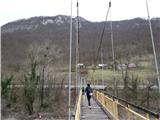 2
2 3
3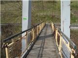 4
4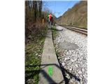 5
5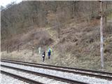 6
6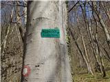 7
7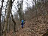 8
8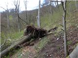 9
9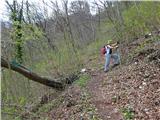 10
10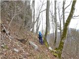 11
11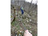 12
12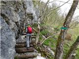 13
13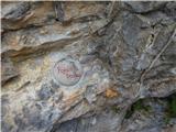 14
14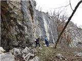 15
15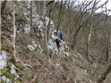 16
16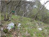 17
17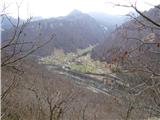 18
18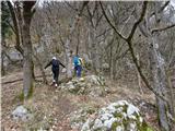 19
19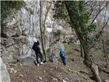 20
20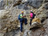 21
21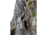 22
22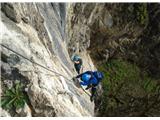 23
23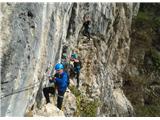 24
24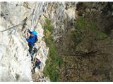 25
25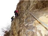 26
26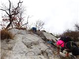 27
27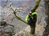 28
28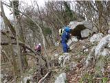 29
29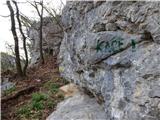 30
30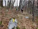 31
31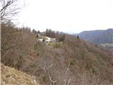 32
32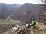 33
33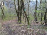 34
34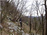 35
35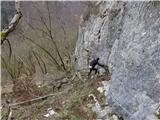 36
36 37
37 38
38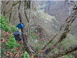 39
39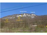 40
40
Discussion about the trail Renke - Climbing area and ferrata Renke (panoramic path on ferrata to Spital)
|
| garmont5. 04. 2019 |
Manjka oznaka zahtevnosti poti...
|
|
|
|
| Tadej5. 04. 2019 |
Sem dodal zahtevnost, če je pravilno pa naj alyas potrdi.
|
|
|
|
| don kihott5. 04. 2019 |
Lepo,da nastajajo nove ferate v Sloveniji in da tudi na tem področju gremo v korak z časom in z tujino...Ocena te ferate je okoli B/C,višje ocene ferata z skobami skorajda ne more imeti 
|
|
|
|
| gams110. 04. 2019 |
Povzetek, na kratko: Kač ne srečam rad, a jih pri našem obisku tudi nismo videli, feratica je »kratka in sladka«, plezalne smeri v plezališču so cca 20 do 30 m višine, ampak so na splošno težke, celotna pot je smiselno in dobro označena, ne moreš falit. Da bo vse tako, kot imajo veliki (ali bolj znani kraji), manjka na koncu samo še kaka skrinjica z vpisno knjižico in zabeležkami o vtisih na poti.  Za malo daljši ali pa celodnevni izlet, če niste ljubitelj plezanja na steni, se lahko podate še na bližnja nasproti ležeča hriba: na Ostrež (lahka označena pot), ali na Kleviško Špico ali pa Žamboh (zahtevnejša neoznačena pot), malo dlje je do Zasavske gore. Skratka: veliko stvari na enem mestu in za vsakogar nekaj. Tako kot piše v opisu: v mokrem zelo nevarno za zdrs!  V dolini, ob glavni cesti na Spodnjem Logu, je v bližini izhodišča, tudi majhna in prijetna gostilna z dobro hrano, Kuhla po imenu. 
|
|
|
|
| Michel14. 04. 2019 |
Pohvale vsem, ki so uredili ferato in pot.
Dostop je lepo urejen in označen, v mokrem vremenu bodite pozorni, ker drsi.
|
|
|
|
| VanSims5. 05. 2019 |
Bi se tokrat kar strinjal z @don_kihottom. B/C,ki morda mestoma diši po C-ju. Kje je tisti C/D, ki ga avtor omenja pa ne vem.  Če pa bi npr. pri tistih dveh vrstah previsnih skob proti koncu, vzeli ven zgornjo in bi se bilo treba vleči po zajli pa bi verjetno to res bil vsaj C/D. Žal zaradi bližine mraka nisem imel časa še enkrat sprobati ferate v tem smislu.
|
|
|
|
| fico20. 10. 2019 |
Dostop do ferate približno 35 minut.
Če v ferati ne uporabljaš skob je kar zahtevna in precej zračna.
Razgledišče slabo označeno, greš gor, dol in ne veš kje je razgledišče.
Pri sestopu steza slabo označena in slabo uhojena.
Primerna le za suho vreme v času, ko ni bujnega rastja. Zelo priporočljiva uporaba pohodnih palic.
Kar se same ferate tiče imaš en obisk dovolj.
Stena dopušča trasiranje zahtevnejšega odseka ferate.
|
|
|
|
| 75'er14. 06. 2020 |
S časom dostopa se strinjam s ficotom. Skupno trajanje do razglednika in nazaj pa maksimalno 2 uri in še to je zelo radodarno. Pot je sveže pokošena.
Ferata je žal kratka, je pa dobra izkušnja za tiste, ki niso vajenih ohlapnih jeklenic, za razliko od npr. Lisce.
|
|
|
|
| grega_p22. 03. 2021 |
Most oz. brv čez Savo je že kar v slabem stanju. Sicer ne strukturno, bolj v smislu majavih desk na tleh. Tako da skoraj že postaja "horizontalna ferata".
Drugače pa pohvale za ureditev ferate in oznak tudi z moje strani. Le tisti previs s skobami mi ni preveč dišal, sem bolj ljubitelj naravnih prehodov. Za vsakega nekaj...
|
|
|
|
| balon22. 08. 2022 09:01:39 |
Pozdravljeni,
včeraj bila s hčerjo. Bilo je super. Označeno je zelo dobro. Kač nisva zasledila, zato kar pogumno. Darovala prostovoljni prispevek (kovinska škatla na začetku in koncu ferate) za vse, ki skrbijo in urejajo, da nam je plezališče na voljo.
A&K
|
|
|
|
| VanSims27. 12. 2023 09:03:14 |
Odprli so novo ferato (D/E, brez skob). Vstop je nekaj deset metrov naprej od vstopa v staro.
|
|
|