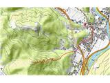
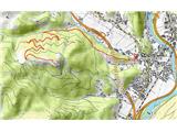
 | Polhov Gradec (Božna) - Polhograjska Grmada (via Setnica)
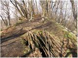
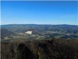
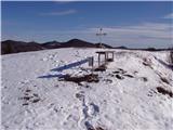
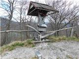
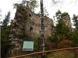
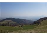
Polhograjska Grmada is an 898 m high peak located in the heart of the Polhograjski Dolomiti. The summit, which has a registration box with a stam...
1 h 30 min |
 | Belica - Polhograjska Grmada
Polhograjska Grmada is an 898 m high peak located in the heart of the Polhograjski Dolomiti. The summit, which has a registration box with a stam...
1 h 30 min |
 | Dvor - Polhograjska Grmada
Polhograjska Grmada is an 898 m high peak located in the heart of the Polhograjski Dolomiti. The summit, which has a registration box with a stam...
2 h 10 min |
 | Polhov Gradec - Polhograjska Grmada (via Ravnek and Mala Grmada)
Polhograjska Grmada is an 898 m high peak located in the heart of the Polhograjski Dolomiti. The summit, which has a registration box with a stam...
1 h 30 min |
 | Polhov Gradec (Božna) - Polhograjska Grmada (via Mačkov graben)
Polhograjska Grmada is an 898 m high peak located in the heart of the Polhograjski Dolomiti. The summit, which has a registration box with a stam...
1 h 30 min |
| Dvor - Polhograjska Grmada (via Mala Grmada)
Polhograjska Grmada is an 898 m high peak located in the heart of the Polhograjski Dolomiti. The summit, which has a registration box with a stam...
1 h 45 min |
 | Gabrje - Polhograjska Grmada
Polhograjska Grmada is an 898 m high peak located in the heart of the Polhograjski Dolomiti. The summit, which has a registration box with a stam...
2 h 20 min |
 | Polhov Gradec - Polhograjska Grmada (via Ravnek)
Polhograjska Grmada is an 898 m high peak located in the heart of the Polhograjski Dolomiti. The summit, which has a registration box with a stam...
1 h 30 min |
| Dvor - Polhograjska Grmada
Polhograjska Grmada is an 898 m high peak located in the heart of the Polhograjski Dolomiti. The summit, which has a registration box with a stam...
1 h 45 min |
 | Preska - Sveti Jakob
The Church of St James is located on a hill north of the village of Topol near Medvode. From the top, where there is a registration box with a st...
1 h 45 min |
| Sora - Sveti Jakob
The Church of St James is located on a hill north of the village of Topol near Medvode. From the top, where there is a registration box with a st...
1 h 45 min |
 | Gabrje - Sveti Jakob
The Church of St James is located on a hill north of the village of Topol near Medvode. From the top, where there is a registration box with a st...
1 h 30 min |
| Preval - Sveti Jakob
The Church of St James is located on a hill north of the village of Topol near Medvode. From the top, where there is a registration box with a st...
2 h 5 min |
 | Žlebe - Sveti Jakob (via Turnice)
The Church of St James is located on a hill north of the village of Topol near Medvode. From the top, where there is a registration box with a st...
2 h |
| Žlebe - Sveti Jakob (via Jeterbenk)
The Church of St James is located on a hill north of the village of Topol near Medvode. From the top, where there is a registration box with a st...
2 h 15 min |
 | Slavkov dom na Golem Brdu - Sveti Jakob
The Church of St James is located on a hill north of the village of Topol near Medvode. From the top, where there is a registration box with a st...
2 h 5 min |
 | Polhov Gradec - Tošč (via Grmada)
Tošč, which became the highest peak of Polhograjsko hribovje decades ago when Pasja ravan was lowered by 9 m by the Yugoslav army, is located nor...
2 h 30 min |
 | Polhov Gradec - Tošč (via Mačkov graben)
Tošč, which became the highest peak of Polhograjsko hribovje decades ago when Pasja ravan was lowered by 9 m by the Yugoslav army, is located nor...
1 h 50 min |
 | Škofja Loka (Vincarje) - Lubnik (ridge path)
Lubnik is a 1025 m high mountain rising steeply to the west of Škofja Loka. From the summit, on which the mountain lodge stands, you can enjoy a ...
2 h 15 min |
 | Škofja Loka - Lubnik (via Stari grad)
Lubnik is a 1025 m high mountain rising steeply to the west of Škofja Loka. From the summit, on which the mountain lodge stands, you can enjoy a ...
2 h 15 min |
| Škofja Loka - Lubnik (via Luža)
Lubnik is a 1025 m high mountain rising steeply to the west of Škofja Loka. From the summit, on which the mountain lodge stands, you can enjoy a ...
2 h |
 | Praprotno - Lubnik
Lubnik is a 1025 m high mountain rising steeply to the west of Škofja Loka. From the summit, on which the mountain lodge stands, you can enjoy a ...
2 h 15 min |
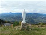
 | Pirman - Kurešček
Kurešček is an 826 m high peak located south of Ig and south-west of Želimlje. The view from the top, on which the church stands, is not possible...
1 h 45 min |
| Želimlje - Kurešček
Kurešček is an 826 m high peak located south of Ig and south-west of Želimlje. The view from the top, on which the church stands, is not possible...
1 h 50 min |
 | Sora - Osolnik (by road)
Osolnik is an 858 m high mountain located south of Škofja Loka and west of Medvode. From the top, where the Church of St. Mohor and Fortunatus st...
1 h 40 min |
 | Sora - Osolnik (via Hom)
Osolnik is an 858 m high mountain located south of Škofja Loka and west of Medvode. From the top, where the Church of St. Mohor and Fortunatus st...
1 h 50 min |
 | Puštal - Osolnik
Osolnik is an 858 m high mountain located south of Škofja Loka and west of Medvode. From the top, where the Church of St. Mohor and Fortunatus st...
2 h 15 min |
 | Sora - Osolnik (on footpath)
Osolnik is an 858 m high mountain located south of Škofja Loka and west of Medvode. From the top, where the Church of St. Mohor and Fortunatus st...
1 h 35 min |
| Puštal (Na Dobravi) - Osolnik
Osolnik is an 858 m high mountain located south of Škofja Loka and west of Medvode. From the top, where the Church of St. Mohor and Fortunatus st...
2 h |
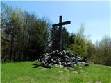
 | Gabrje - Jeterbenk
Jeterbenk is a 774 m high peak located between Slavko's home at Gole Brdo and Katarina (Topol village). From the top, where there is a large cros...
1 h 30 min |
| Preval - Jeterbenk
Jeterbenk is a 774 m high peak located between Slavko's home at Gole Brdo and Katarina (Topol village). From the top, where there is a large cros...
2 h 5 min |
 | Preska - Jeterbenk (via Turnice)
Jeterbenk is a 774 m high peak located between Slavko's home at Gole Brdo and Katarina (Topol village). From the top, where there is a large cros...
2 h 15 min |
 | Preska - Jeterbenk (on ridge)
Jeterbenk is a 774 m high peak located between Slavko's home at Gole Brdo and Katarina (Topol village). From the top, where there is a large cros...
2 h 15 min |
 | Briše - Polhograjska Gora (Sveti Lovrenc) (gentle path)
Polhograjska Gora, also just Gora or Sveti Lovrenc, is an 824 m high hill located north-west of Polhov Gradec. From the top of the hill, where th...
1 h 35 min |
 | Loke - Krvavica (via Zajčeva koča)
Krvavica is a 909m high peak located to the east of Čemšeniška mountain pasture. From the summit, which descends steeply on all sides, there is a...
2 h 10 min |
 | Hotovlja - Pasja ravan
Pasja ravan is the second highest peak in the Polhograje Hills. A few decades ago, at 1029 m, it was the highest peak, but the Yugoslav army flat...
1 h 45 min |
 | Blagovica - Limbarska gora
Limbarska gora is located north-east of Moravce. From the top there is a beautiful view of the surrounding peaks and in good weather you can also...
1 h 30 min |
 | Lake Gradišče - Limbarska gora
Limbarska gora is located north-east of Moravce. From the top there is a beautiful view of the surrounding peaks and in good weather you can also...
1 h 55 min |
 | Puštal (Na Dobravi) - Sveti Ožbolt (above Zminec)
Sveti Ožbolt is located on a scenic peak in the north of the Polhograjske Dolomites. It has a beautiful view of the Škofjeloško hribovje and part...
2 h 15 min |
 | Crngrob - Archangel Gabriel (Planica)
Planica is an 824 m high peak located north of Škofja Loka, between Krizna Gora and Planica. From the top, where the Church of St. Gabriel the Ar...
1 h 30 min |
 | Moškrin - Archangel Gabriel (Planica)
Planica is an 824 m high peak located north of Škofja Loka, between Krizna Gora and Planica. From the top, where the Church of St. Gabriel the Ar...
1 h 30 min |
 | Rakovica - Archangel Gabriel (Planica)
Planica is an 824 m high peak located north of Škofja Loka, between Krizna Gora and Planica. From the top, where the Church of St. Gabriel the Ar...
2 h 30 min |
 | Pevno - Archangel Gabriel (Planica)
Planica is an 824 m high peak located north of Škofja Loka, between Krizna Gora and Planica. From the top, where the Church of St. Gabriel the Ar...
1 h 30 min |
| Škofja Loka - Archangel Gabriel (Planica)
Planica is an 824 m high peak located north of Škofja Loka, between Krizna Gora and Planica. From the top, where the Church of St. Gabriel the Ar...
2 h 5 min |
 | Famlje - Vremščica
Vremščica is a mountain chain, stretching between Senožeče, Pivka and Divača. The highest top is also called Vremščica and the view from it is am...
2 h 30 min |
 | Vrhnika-Tankovska cesta - Koča na Planini nad Vrhniko (Circular path Vrhnika-Planina-Lintvern-Vrhnika)
Planina above Vrhnika is for hers inhabitants something like Šmarna gora for inhabitants of Ljubljana. It is 733 metres high and is reachable fro...
2 h 20 min |
 | Besnica - Janče
Janče is a 792-metre-high peak located between the Sava River and the valley of the Besnica Stream. From the top, where the mountain lodge stands...
2 h 15 min |
 | Jevnica - Janče
Janče is a 792-metre-high peak located between the Sava River and the valley of the Besnica Stream. From the top, where the mountain lodge stands...
1 h 45 min |
 | Laze pri Dolskem - Janče
Janče is a 792-metre-high peak located between the Sava River and the valley of the Besnica Stream. From the top, where the mountain lodge stands...
2 h 15 min |
 | Kamnica - Sveti Miklavž above Sava (via Velika vas)
The Church of St Nicholas is situated on a hill south of Moravče. From the top you can enjoy a beautiful view of the nearby Limbarska gora, and t...
2 h 5 min |
 | Senožeti - Cicelj
Cicelj is a forested peak located between Moravče and the village of Senožeti. There is no view from the top, which has a bench and a registratio...
1 h 30 min |
 | Kamnica - Cicelj (via farm Buven)
Cicelj is a forested peak located between Moravče and the village of Senožeti. There is no view from the top, which has a bench and a registratio...
1 h 45 min |
 | Kamnica - Cicelj
Cicelj is a forested peak located between Moravče and the village of Senožeti. There is no view from the top, which has a bench and a registratio...
1 h 40 min |
 | Senožeti - Cicelj (hunting path)
Cicelj is a forested peak located between Moravče and the village of Senožeti. There is no view from the top, which has a bench and a registratio...
1 h 30 min |
 | Stomaž - Mala gora
Mala gora is a plateau on the slope of the Chavn. A hut is located at an altitude of 1034 metres. Mala gora is known for its flowers, which are u...
2 h |
 | Vrtovin - Mala gora
Mala gora is a plateau on the slope of the Chavn. A hut is located at an altitude of 1034 metres. Mala gora is known for its flowers, which are u...
2 h 15 min |
 | Hrastnik - Dom v Gorah
The mountain lodge in Gora is located east of Hrastnik, just a few metres below the 786m-high peak on which the Church of St George stands. From ...
1 h 30 min |
 | Moravče - Slivna (Pivkelj)
Slivna or Pivkelj (also Pivkelj turn) as this peak is also called is located south of Limbarska Gora. Pivkelj is also the highest point of the Mo...
2 h 30 min |
 | Source of Hubelj - Navrše
Navrše is a little-known peak located southeast of the Otliška Window. From the top there is a beautiful view of the Vipava valley and the peaks ...
1 h 35 min |
 | Brzika - Donačka gora
Donačka gora is a peak located north of Rogatec. The peak, which geographically belongs to Karawanks, offers a beautiful view of the surrounding ...
1 h 45 min |
| Stoperce - Donačka gora
Donačka gora is a peak located north of Rogatec. The peak, which geographically belongs to Karawanks, offers a beautiful view of the surrounding ...
2 h 5 min |
| Sveti Jurij - Donačka gora (western path)
Donačka gora is a peak located north of Rogatec. The peak, which geographically belongs to Karawanks, offers a beautiful view of the surrounding ...
1 h 35 min |
 | Polzela - Gora Oljka (via Vimperk)
Gora Oljka is a hill located east of Šmartno ob Paki. On the top stands the Church of the Holy Cross, which was built in the mid-18th century. Ju...
2 h 15 min |
| Podvin pri Polzeli - Gora Oljka (upper path)
Gora Oljka is a hill located east of Šmartno ob Paki. On the top stands the Church of the Holy Cross, which was built in the mid-18th century. Ju...
1 h 35 min |
 | Spodnja Rečica - Dom na Šmohorju (via Tolsto)
Dom na Šmohorju is located between Laško, Liboje and Zabukovica. From the house, or from the Church of St. Mohorj, a few minutes away, there is a...
1 h 35 min |
| Laško - Dom na Šmohorju
Dom na Šmohorju is located between Laško, Liboje and Zabukovica. From the house, or from the Church of St. Mohorj, a few minutes away, there is a...
2 h |
 | Liboje - Dom na Šmohorju (via organic farm Kralj)
Dom na Šmohorju is located between Laško, Liboje and Zabukovica. From the house, or from the Church of St. Mohorj, a few minutes away, there is a...
1 h 30 min |
 | Spodnja Rečica - Malič (via Tolsto)
Malič is a 936 m high peak located between Celje and Laško, above Spodnja Rečica. There is no better view from the top, where the transmitter, be...
2 h 15 min |
| Laško - Malič
Malič is a 936 m high peak located between Celje and Laško, above Spodnja Rečica. There is no better view from the top, where the transmitter, be...
2 h 15 min |
 | Tremerje - Malič (on western ridge of Malič)
Malič is a 936 m high peak located between Celje and Laško, above Spodnja Rečica. There is no better view from the top, where the transmitter, be...
2 h |
 | Gradišče - Gradiška Tura (via Plaz)
Gradiška Tura is a peak located on the western side of the Nanoška plateau. From the top, which is reached by a well-maintained climbing route an...
2 h |
 | Zagrad - Tolsti vrh above Celjska koča (eastern way)
Tolsti, according to some records also Tovsto vrh, is located above the Celjska koča ski resort. The summit, which has a registration box and a s...
1 h 45 min |
 | Zagrad - Tolsti vrh above Celjska koča (Po vrheh)
Tolsti, according to some records also Tovsto vrh, is located above the Celjska koča ski resort. The summit, which has a registration box and a s...
1 h 40 min |
 | Štore - Tolsti vrh above Celjska koča (via Bojanski graben)
Tolsti, according to some records also Tovsto vrh, is located above the Celjska koča ski resort. The summit, which has a registration box and a s...
2 h 30 min |
 | Štore - Tolsti vrh above Celjska koča (via Marija)
Tolsti, according to some records also Tovsto vrh, is located above the Celjska koča ski resort. The summit, which has a registration box and a s...
2 h |
 | Hayrack (Laška vas - Pečovje) - Tolsti vrh above Celjska koča (via chapel at Mary and on CPP)
Tolsti, according to some records also Tovsto vrh, is located above the Celjska koča ski resort. The summit, which has a registration box and a s...
1 h 35 min |
 | Zvodno - Tolsti vrh above Celjska koča (via Suhi potok)
Tolsti, according to some records also Tovsto vrh, is located above the Celjska koča ski resort. The summit, which has a registration box and a s...
1 h 30 min |
 | Zvodno - Tolsti vrh above Celjska koča (via Marija)
Tolsti, according to some records also Tovsto vrh, is located above the Celjska koča ski resort. The summit, which has a registration box and a s...
1 h 40 min |
 | Zvodno - Tolsti vrh above Celjska koča (via Suhi potok and on ski slope)
Tolsti, according to some records also Tovsto vrh, is located above the Celjska koča ski resort. The summit, which has a registration box and a s...
1 h 30 min |
| Zvodno - Tolsti vrh above Celjska koča (via Srebotnik on CPP)
Tolsti, according to some records also Tovsto vrh, is located above the Celjska koča ski resort. The summit, which has a registration box and a s...
2 h 15 min |
| Hayrack (Laška vas - Pečovje) - Tolsti vrh above Celjska koča (via Srebotnik on CPP)
Tolsti, according to some records also Tovsto vrh, is located above the Celjska koča ski resort. The summit, which has a registration box and a s...
2 h 15 min |
 | Slovenske Konjice - Stolpnik (Zmajčkova pot)
At 1012 m, Stolpnik is the highest peak of the Konjiška Gora, a mountain range stretching south-west from Slovenske Konjice. A 25 m high lookout ...
1 h 45 min |
 | Žička kartuzija - Stolpnik (via Krniški rob)
At 1012 m, Stolpnik is the highest peak of the Konjiška Gora, a mountain range stretching south-west from Slovenske Konjice. A 25 m high lookout ...
2 h 30 min |
 | Spodnje Stranice (graves of hundred hostages) - Stolpnik (via hunting cottage Štepih)
At 1012 m, Stolpnik is the highest peak of the Konjiška Gora, a mountain range stretching south-west from Slovenske Konjice. A 25 m high lookout ...
2 h |
 | Spodnje Stranice (graves of hundred hostages) - Stolpnik (via Grofov štant)
At 1012 m, Stolpnik is the highest peak of the Konjiška Gora, a mountain range stretching south-west from Slovenske Konjice. A 25 m high lookout ...
2 h 10 min |
 | Frankolovo - Stolpnik
At 1012 m, Stolpnik is the highest peak of the Konjiška Gora, a mountain range stretching south-west from Slovenske Konjice. A 25 m high lookout ...
2 h 30 min |
 | Slovenske Konjice - Skala (gentle path)
Skala is a viewpoint on the eastern part of Konjiška Gora. From the viewpoint, which has a table, bench and a registration box, there is a beauti...
1 h 30 min |
 | Lašče - Sveti Peter
Sveti Peter is a partially vegetated peak in the Dry Krajina above the village of Dvor. On the top there is a small shelter (usually open on Sund...
1 h 45 min |
 | Preval - Rog
The Rog is a 798 m high peak located above the village of Topole, just 10 minutes from St Catherine's Church. From the top of the hill, where a l...
1 h 55 min |
 | Preska - Rog (via Turnice)
The Rog is a 798 m high peak located above the village of Topole, just 10 minutes from St Catherine's Church. From the top of the hill, where a l...
2 h 30 min |
| Žlebe - Rog (via Jeterbenk)
The Rog is a 798 m high peak located above the village of Topole, just 10 minutes from St Catherine's Church. From the top of the hill, where a l...
1 h 40 min |
 | Hunting cottage Budanje - Kovk
Kovk is a scenic peak located to the west of Cola, on a jagged ridge rising steeply above the Vipava valley. From the top with a cross, we have a...
1 h 30 min |
 | Hrastnik - Klobuk (via Jelenca)
Klobuk is a scenic peak located northeast of Hrastnik. The summit, which has a registration box and a stamp, offers a beautiful view of the valle...
1 h 30 min |
| Hrastnik - Klobuk (via Ravne)
Klobuk is a scenic peak located northeast of Hrastnik. The summit, which has a registration box and a stamp, offers a beautiful view of the valle...
2 h 25 min |
 | Hrastnik - Kal (via Ravne)
Kal is a 985m high peak located between the more famous Mrzlica and the lesser known Klobuk. From the top where the bench stands, there is no bet...
2 h 25 min |
 | Bresternica (spodnji Rušnik) - Žavcarjev vrh
Žavcarjev vrh is a 915m high mountain located north of the River Drava on the slopes of Kozjak. As the peak is completely overgrown, there is no ...
1 h 40 min |
 | Jelovec - Žavcarjev vrh
Žavcarjev vrh is a 915m high mountain located north of the River Drava on the slopes of Kozjak. As the peak is completely overgrown, there is no ...
2 h 25 min |
 | Senožeti - Murovica (via Vrh pri Dolskem)
Murovica is a popular excursion point, accessible from the Posavina side, Domžale or from the Moravška valley. There is a bench and a registratio...
2 h 5 min |
| Senožeti - Murovica (via farm Buven)
Murovica is a popular excursion point, accessible from the Posavina side, Domžale or from the Moravška valley. There is a bench and a registratio...
1 h 55 min |
 | Laško (pokopališče Laško) - Govško brdo
Govško brdo is an 811m high hill located west of the village of Huda jama above Laško. From the top of the hill, where the registration box and s...
2 h 35 min |
 | Borovnica - Mali Trebelnik
Mali Trebelnik is an 807 m high peak rising above the south-western part of the Ljubljana Marshes. Partly grassy and partly surrounded by forest,...
1 h 30 min |
 | Bistra - Mali Trebelnik
Mali Trebelnik is an 807 m high peak rising above the south-western part of the Ljubljana Marshes. Partly grassy and partly surrounded by forest,...
1 h 45 min |
 | Socka - Špicasti vrh (Kislica)
Špičasti vrh aka Kislica (the name of a small ridge south of Mala gora and the town of Vitanje) is a 994 m hill situated between Vojnik and Stran...
2 h 15 min |
 | Trbovlje - Sveta planina (Partizanski vrh)
Sveta planina, also Partizanski vrh, is a 1011 m high mountain located between Čemšeniška mountain pasture and Mrzlica. From the top, where a sma...
2 h |
 | Loke - Sveta planina (Partizanski vrh)
Sveta planina, also Partizanski vrh, is a 1011 m high mountain located between Čemšeniška mountain pasture and Mrzlica. From the top, where a sma...
2 h 25 min |
 | Radlje ob Dravi - Kapunar / Kapunerkogel
Kapunar is a 1051 m high peak above Radlje ob Dravi. Just below the peak is an old caravan and border guardhouse, which is now used by radio amat...
2 h 15 min |
 | Radlje ob Dravi - Kapunar / Kapunerkogel (via Župank)
Kapunar is a 1051 m high peak above Radlje ob Dravi. Just below the peak is an old caravan and border guardhouse, which is now used by radio amat...
2 h 30 min |
| Radlje ob Dravi - Kapunar / Kapunerkogel (via old castle)
Kapunar is a 1051 m high peak above Radlje ob Dravi. Just below the peak is an old caravan and border guardhouse, which is now used by radio amat...
2 h 30 min |
 | Dvor - Mala Grmada
Mala Grmada is an 853 m high peak located south-west of the slightly higher Polhograjska Grmada. From the top, you have a beautiful view over the...
1 h 30 min |
 | Trnovec - Gontarska planina
Gontarska planina is an 894 m high mountain located between Osolnik and Tosce. From the top, where there are two benches, we have a beautiful vie...
1 h 30 min |
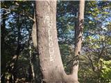
 | Gabrje - Goljek
Goljek is an 809 m high peak located east of Polhograjska Grmada. The view from the summit, which is home to the remains of a former watchtower o...
1 h 40 min |
 | Blagovica - Špilk
Špilk is a 956 m high peak located north of Blagovica. On the summit, which is mostly forested, PD Blagovica has built a small bivouac with a ben...
1 h 30 min |
 | Zazid - Golič
Golič is a grassy ridge stretching from Kojnik to the Slovenian-Croatian border and continuing to Žbevnica on the Croatian side. Due to the relat...
1 h 30 min |
 | Zazid - Golič (via Lipnik)
Golič is a grassy ridge stretching from Kojnik to the Slovenian-Croatian border and continuing to Žbevnica on the Croatian side. Due to the relat...
2 h 30 min |
 | Zazid - Golič (via Kojnik)
Golič is a grassy ridge stretching from Kojnik to the Slovenian-Croatian border and continuing to Žbevnica on the Croatian side. Due to the relat...
2 h 30 min |
 | Hotavlje - Štor (by road)
Štor is a 1005 m high peak located directly above the Ermanovec Cottage. The peak itself is covered with forest, but from the meadow, which is on...
2 h 15 min |
 | Spodnja Besnica (fish farm) - Špičasti hrib
Špičasti hrib (Špičasti vrh on maps) is an 837 m high peak located to the west of Sveti Jošto above Kranj. There is no view from the top, which h...
1 h 30 min |
| Rakovica - Špičasti hrib
Špičasti hrib (Špičasti vrh on maps) is an 837 m high peak located to the west of Sveti Jošto above Kranj. There is no view from the top, which h...
2 h 20 min |
 | Zazid - Kavčič (via Lipnik)
Kavčič is a grassy peak located above the village of Rakitovec on the Slovenian Croatian border. From the top, where there are two crosses and a ...
2 h 30 min |
 | Zazid - Nadglavinjak (via Lipnik)
Nadglavinjak is a lesser known peak located southeast of Golič. From the unmarked and grassy peak, we have a beautiful view of Slavnik, Čičarija,...
2 h 10 min |
 | Sveti Mavricij - Sveti Socerb (Artviže)
The Church of St. Socerbo is situated on a hill overloking the village of Artviže, which is the highest peak in Brkina with its 817 m. The church...
2 h 15 min |
 | Cerkno - Veliki vrh (Lajše)
Veliki vrh is an almost 900 m high peak rising south of Cerkno. From the top, where there are several television and radio transmitters covering ...
2 h |
 | Cerkno - Škofje
Škofje is a 973 m high peak located above the villages of Čeplez, Planina pri Cerknem and Podpleče. The peak itself, on which stands a small conc...
1 h 45 min |
 | Renke - Ostrež
Ostrež is an 856 m high hill in the Posavje Hills. It rises south of the Sava River valley, above the main road Litija - Zagorje ob Savi....
1 h 30 min |
 | Krače - Roviškovec (west path)
Roviškovec (also Roviški vrh) is a 930 m high peak located southeast of Zasavska Svatá gora. From the top, which is mostly covered with forest an...
1 h 30 min |
 | Krače - Roviškovec (east path)
Roviškovec (also Roviški vrh) is a 930 m high peak located southeast of Zasavska Svatá gora. From the top, which is mostly covered with forest an...
1 h 30 min |
 | Mlinše - Pleše (via Zasavska Sveta gora)
Pleše is an 866 m high peak located between the Marela Ski Resort and Zasavska Sveta Gora. From the top, where the NOB monument is located, you h...
2 h 30 min |
| Krače - Pleše
Pleše is an 866 m high peak located between the Marela Ski Resort and Zasavska Sveta Gora. From the top, where the NOB monument is located, you h...
1 h 45 min |
 | Izlake - Pleše (via Grobovščica)
Pleše is an 866 m high peak located between the Marela Ski Resort and Zasavska Sveta Gora. From the top, where the NOB monument is located, you h...
2 h 15 min |
 | Izlake - Pleše (via Vežnica)
Pleše is an 866 m high peak located between the Marela Ski Resort and Zasavska Sveta Gora. From the top, where the NOB monument is located, you h...
1 h 45 min |
 | Braslovško jezero - Bezovec (Dobrovlje) (via hunting cottage)
Bezovec, also Brezovec on some maps, is an 857 m high peak located west of Braslov Lake, more precisely on the eastern part of the Dobrovlje plat...
1 h 30 min |
 | Braslovško jezero - Bezovec (Dobrovlje) (via Covnikov križ)
Bezovec, also Brezovec on some maps, is an 857 m high peak located west of Braslov Lake, more precisely on the eastern part of the Dobrovlje plat...
1 h 30 min |
| Letuš - Bezovec (Dobrovlje) (via hunting cottage)
Bezovec, also Brezovec on some maps, is an 857 m high peak located west of Braslov Lake, more precisely on the eastern part of the Dobrovlje plat...
1 h 30 min |
| Letuš - Bezovec (Dobrovlje) (via Covnikov križ)
Bezovec, also Brezovec on some maps, is an 857 m high peak located west of Braslov Lake, more precisely on the eastern part of the Dobrovlje plat...
1 h 30 min |
 | Braslovško jezero - Grmada (Dobrovlje)
Grmada is an 898 m high forested peak located in the south-eastern part of the Dobrovlje plateau. The summit, on which the stamp is located, is n...
2 h 25 min |
| Letuš - Grmada (Dobrovlje)
Grmada is an 898 m high forested peak located in the south-eastern part of the Dobrovlje plateau. The summit, on which the stamp is located, is n...
2 h 25 min |
| Žovneško jezero - Grmada (Dobrovlje)
Grmada is an 898 m high forested peak located in the south-eastern part of the Dobrovlje plateau. The summit, on which the stamp is located, is n...
2 h 5 min |
 | Divje jezero - Zagrebenc
Zagrebenc on some maps also Čekovnik is a 763 m high peak located between Hleviška planina and the valley of the Idrijca River. The grassy peak, ...
1 h 30 min |
 | Zagreb (Šestine) - Sljeme (path HPD (path 52))
...
2 h 15 min |
 | Matrafuered - Kékestető (pot modri križ)
Matra is a mountain range located 70 km east of Budapest. The two highest peaks in Hungary are Kékestető, which is the highest peak in Hungary at...
2 h |
 | Matrafuered - Kékestető (Marijina pot)
Matra is a mountain range located 70 km east of Budapest. The two highest peaks in Hungary are Kékestető, which is the highest peak in Hungary at...
2 h |
 | Matrafüred - Kékestető (pot modri trikotnik)
Matra is a mountain range located 70 km east of Budapest. The two highest peaks in Hungary are Kékestető, which is the highest peak in Hungary at...
2 h |
 | Gorenja vas - Javorč (via Jermanca)
Javorč is a 901-metre-high peak located to the north-east of Žiri. The summit, where the registration box with the registration book is located, ...
2 h |
| Dolenja Dobrava - Javorč
Javorč is a 901-metre-high peak located to the north-east of Žiri. The summit, where the registration box with the registration book is located, ...
1 h 30 min |
 | Lesično - Oslica (Bohor)
Oslica is one of the peaks of Bohor. It is located in the eastern part of the mountain range. Unlike some of the higher peaks of Bohor, such as V...
1 h 45 min |
 | Kozje - Oslica (Bohor) (via Vetrnik)
Oslica is one of the peaks of Bohor. It is located in the eastern part of the mountain range. Unlike some of the higher peaks of Bohor, such as V...
2 h 10 min |
 | Lesično - Debeli vrh (Bohor)
Debeli vrh is a 921-metre-high peak on Bohor between Veliki Koprivnik and Oslice. It is overgrown with dense forest, so there are no views. There...
1 h 45 min |
 | Kozje - Debeli vrh (Bohor) (via Vetrnik)
Debeli vrh is a 921-metre-high peak on Bohor between Veliki Koprivnik and Oslice. It is overgrown with dense forest, so there are no views. There...
2 h 35 min |
 | Lesično - Brest (Bohor)
Brest is a peak on Bohor although it loks more like a saddle. It is an important intersection of the Bohor trails. It lies between Oslica, which ...
1 h 30 min |
 | Kozje - Brest (Bohor) (via Vetrnik)
Brest is a peak on Bohor although it loks more like a saddle. It is an important intersection of the Bohor trails. It lies between Oslica, which ...
2 h |
 | Štore - Veliki vrh above Svetina (via Marija and over Svetina)
Veliki vrh is located south-west of Svetina above Štorá. It is inhabited mainly from the south and one of the homesteads is directly below the pe...
2 h 30 min |
 | Štore - Veliki vrh above Svetina (via Žlajfa and via Svetina)
Veliki vrh is located south-west of Svetina above Štorá. It is inhabited mainly from the south and one of the homesteads is directly below the pe...
2 h 15 min |
 | Štore - Veliki vrh above Svetina (through Bojanski graben and over Svetina)
Veliki vrh is located south-west of Svetina above Štorá. It is inhabited mainly from the south and one of the homesteads is directly below the pe...
2 h 30 min |
| Krka - Ciganov vrh (Korinjski hrib) (part of circular path Prijetno domače)
Ciganov vrh or Korinjski hill is a small hill rising above the valley of the river Krka, from which we have a view of the rather woded surroundin...
1 h 45 min |
 | Studenice - Plešivec (pri Boču)
Peace, silence, rugged terrain... the characteristics of a peak at the "crossroads" of many routes between the Maribor, Celje and Ptuj areas. Ple...
2 h |
 | Studenice - Plešivec (pri Boču) (final part on forest road)
Peace, silence, rugged terrain... the characteristics of a peak at the "crossroads" of many routes between the Maribor, Celje and Ptuj areas. Ple...
2 h |
 | Brzika - Plešivec (pri Boču)
Peace, silence, rugged terrain... the characteristics of a peak at the "crossroads" of many routes between the Maribor, Celje and Ptuj areas. Ple...
2 h 15 min |
 | Podvelka - Hlebov vrh (Rdeči Breg) (via Viltužnik)
The Red Bank stretches between the Radoljna Gorge in the east, the Drava River in the north and the Velka Stream in the east. It is separated fro...
2 h |
 | Hunting cottage Budanje - Podrta gora above Ajdovščina
Podrta gora above Ajdovščina, also called the Broke Mountain above Šturje, is a mountain rising above the Vipava valley. Some time ago, a large c...
1 h 35 min |
 | Hunting cottage Budanje - Kraguljc
Kraguljc is a mountain located between Podrto gora and Sončnica. A trigonometric point is located on the lookout point, which offers a beautiful ...
1 h 25 min |
 | Terme Topolšica - Lomek (Lom)
Lom, with its highest peak Lomek (884 m), is an peak of karst origin, located above the tourist and health resort of Topolšica. From the top, you...
1 h 50 min |
 | Terme Topolšica - Lomek (Lom) (hunting path)
Lom, with its highest peak Lomek (884 m), is an peak of karst origin, located above the tourist and health resort of Topolšica. From the top, you...
1 h 50 min |
 | Ravne na Koroškem - Šteharski vrh (Šteharnikov vrh)
Šteharski or Šteharnikov vrh, also Črneška gora, is a 1018-metre-high mountain located in the south-eastern part of Strojna, a mountain range bet...
1 h 45 min |
| Dravograd lake - Šteharski vrh (Šteharnikov vrh)
Šteharski or Šteharnikov vrh, also Črneška gora, is a 1018-metre-high mountain located in the south-eastern part of Strojna, a mountain range bet...
2 h 15 min |
 | Muta (Spodnja Muta) - Bricnik
Bricnik is a 1017-metre-high peak located in the Kozjak Mountains, above Muta. On the top, which is covered by forest, there is a registration bo...
1 h 50 min |
 | Radlje ob Dravi - Bricnik
Bricnik is a 1017-metre-high peak located in the Kozjak Mountains, above Muta. On the top, which is covered by forest, there is a registration bo...
2 h 30 min |
| Dolina Radeljskega potoka (Razdevšek) - Bricnik
Bricnik is a 1017-metre-high peak located in the Kozjak Mountains, above Muta. On the top, which is covered by forest, there is a registration bo...
2 h 20 min |
 | Volča - Malenski vrh
Malenski vrh is a 1051 m high mountain located west of Javorje. A small bench and cairn are located at the top, and the view of the surrounding h...
1 h 45 min |
 | Radlje ob Dravi - Sveti Trije Kralji (above Radlje ob Dravi)
The Church of the Three Kings is situated on an 820-metre-high hill rising above the right bank of the Radlje Stream. The church offers a beautif...
1 h 40 min |
| Dolina Radeljskega potoka (Razdevšek) - Sveti Trije Kralji (above Radlje ob Dravi)
The Church of the Three Kings is situated on an 820-metre-high hill rising above the right bank of the Radlje Stream. The church offers a beautif...
1 h 30 min |
| Muta (Spodnja Muta) - Sveti Trije Kralji (above Radlje ob Dravi)
The Church of the Three Kings is situated on an 820-metre-high hill rising above the right bank of the Radlje Stream. The church offers a beautif...
2 h 30 min |
 | Dravograd (Meža) - Golarjev vrh
Golarjev vrh is an 843 m high forested peak located south to south-east of the Cvitrško saddle, between Otiški Vrh and Sveti Danijel....
1 h 50 min |
 | Hotavlje - Vrhovski grič (via Slajka)
Vrhovski grič is a scenic hill located along the marked Trebija - Ermanovec trail. The grassy summit offers a beautiful view of the surrounding h...
2 h 30 min |
 | Zia - Dikeos (Kos)
Dikeos (846 m) is the highest mountain on the Kos island, the third-largest Dodecanese island in the southeastern Aegean sea in Greece (after Rho...
1 h 50 min |
 | Velem - Irrotkő / Geschriebenstein (path blue plus)
Irrotkő is the highest peak of the Kőszegi Hegység (Kőszegi Mountains) and also the highest peak in western Hungary and the Austrian state of Bur...
1 h 45 min |
 | Rechnitz (Badesee) - Irrotkő / Geschriebenstein
Irrotkő is the highest peak of the Kőszegi Hegység (Kőszegi Mountains) and also the highest peak in western Hungary and the Austrian state of Bur...
2 h 30 min |
 | Hotavlje - Špik (Vranškov grič)
Špik, also known as Vranškov grič on maps, is a 908 m high mountain located west of Hotavlje. The peak is located in a forest, but the grassy for...
1 h 35 min |
 | Puščava - Klančnik (Glančnik)
Klančnik, also known as Glančnik on some maps, is an 877-metre-high peak located above the right bank of the Drava River, just a few minutes away...
2 h 15 min |
| HE Ožbalt - Klančnik (Glančnik)
Klančnik, also known as Glančnik on some maps, is an 877-metre-high peak located above the right bank of the Drava River, just a few minutes away...
2 h 10 min |
 | Podvelka - Klančnik (Glančnik) (via Sveti Ignacij)
Klančnik, also known as Glančnik on some maps, is an 877-metre-high peak located above the right bank of the Drava River, just a few minutes away...
2 h 30 min |
 | Oplotnica - Kebelj castle (Castle Zajec)
Kebelj or Hare's Castle is located on the eastern top of Hare's Hill, a hill above Keblje....
1 h 25 min |
 | Deutschfeistritz - Gamskogel
Gamskogel is an 859m high hill above the town of Deutschfeistritz (German Bistritz) in Styria, Austria. A cross stands at the top. There is no vi...
1 h 30 min |
 | Deutschfeistritz - Schartnerkogel (on road)
Schartnerkogel is a 931m high hill above the town of Deutschfeistritz (German Bistritz) in the western part of the Graz mountain range. A cross s...
2 h |
 | Center Vintgar - Lookout point at Ančnikovo gradišče (via Bistriški vintgar)
The viewing platform is located close to Ančnik's hillfort. The platform offers a beautiful view. We can see the place Slovenska Bistrica and it...
1 h 30 min |
 | Radoboj - Sekolje (Strahinjčica)
Sekolje are the easternmost peak of Strahinjcica. It is visible as an interesting cone from the surrounding area. The view from the top is limite...
1 h 30 min |
 | Stubenbergsee - Kulm (via Kulmkögerl)
Kulm is a 975-metre-high lookout peak located a short walk from Weiz. From the top, where there are several religious buildings, you can enjoy a ...
2 h |
 | Rechnitz (Badesee) - Großer Hirschenstein
...
2 h |
 | Vuzenica - Sedovnikov vrh
...
2 h 35 min |
 | Selnica ob Dravi - Kranjčeva pečina
...
2 h 10 min |