 | Zapotok - Kurešček
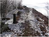
Kurešček is an 826 m high peak located south of Ig and south-west of Želimlje. The view from the top, on which the church stands, is not possible...
45 min |
 | Praproče - Polhograjska Gora (Sveti Lovrenc) (gentle path)
Polhograjska Gora, also just Gora or Sveti Lovrenc, is an 824 m high hill located north-west of Polhov Gradec. From the top of the hill, where th...
50 min |
 | Ljubljanica - Kožljek
Kožljek is a 788 m high peak located to the west of Koreno, specifically above the village of Samotorica. From the top, where there are a few ben...
45 min |
 | Briše - Koreno
Koreno also Koreno is a 729 m high hill located north of Horjul. From the top, where there is a large cross, the Church of St. Mohorj and Fortuna...
50 min |
 | Gabrje - Limbarska gora (footpath)
Limbarska gora is located north-east of Moravce. From the top there is a beautiful view of the surrounding peaks and in good weather you can also...
45 min |
 | Kuren - Koča na Planini nad Vrhniko
Planina above Vrhnika is for hers inhabitants something like Šmarna gora for inhabitants of Ljubljana. It is 733 metres high and is reachable fro...
45 min |
 | Katarija - Sveti Miklavž above Sava
The Church of St Nicholas is situated on a hill south of Moravče. From the top you can enjoy a beautiful view of the nearby Limbarska gora, and t...
45 min |
 | Križevska vas - Cicelj (via farm Buven)
Cicelj is a forested peak located between Moravče and the village of Senožeti. There is no view from the top, which has a bench and a registratio...
45 min |
 | Križevska vas - Cicelj
Cicelj is a forested peak located between Moravče and the village of Senožeti. There is no view from the top, which has a bench and a registratio...
40 min |
 | Kuren - Ulovka
Ulovka is the peak between Zaplana and the Shelter at Mountain pasture above Vrhnika. From the top, which is reached by ski lifts, there is a nic...
50 min |
 | Selšček - Velika Špička
Velika Špička or Špičasto Stražišče is a peak located north of Slivnica. From the top, which has a registration box with a stamp, there is a beau...
45 min |
 | Rudijev dom na Donački gori - Donačka gora
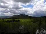
Donačka gora is a peak located north of Rogatec. The peak, which geographically belongs to Karawanks, offers a beautiful view of the surrounding ...
45 min |
 | Dobrič - Gora Oljka
Gora Oljka is a hill located east of Šmartno ob Paki. On the top stands the Church of the Holy Cross, which was built in the mid-18th century. Ju...
50 min |
 | Dobrič (Vedet) - Gora Oljka (via Rogeljšek)
Gora Oljka is a hill located east of Šmartno ob Paki. On the top stands the Church of the Holy Cross, which was built in the mid-18th century. Ju...
40 min |
| Dobrič (Vedet) - Gora Oljka (via Brezovec)
Gora Oljka is a hill located east of Šmartno ob Paki. On the top stands the Church of the Holy Cross, which was built in the mid-18th century. Ju...
50 min |
 | Tržič (Slap) - Kamnek (via Ride)
Kamnek (Kamnik on maps, but also Kamnjek) is a scenic peak above Tržič....
55 min |
 | Križna jama - Križna gora
Križna gora is a partially overloked peak located above the village of Sveta Ana and Podlož. From the top of the hill on which the Church of the ...
35 min |
 | Dule - Kamen vrh
Kamen vrh is a scenic peak located on the northern outskirts of Mala Gora. From the top, surrounded by low bushes, there is a beautiful view of p...
45 min |
 | Podpeč - Kamen vrh
Kamen vrh is a scenic peak located on the northern outskirts of Mala Gora. From the top, surrounded by low bushes, there is a beautiful view of p...
50 min |
 | Ortnek - Ortnek Castle
Ortnek Castle is located on the Veliki Žrnovec escarpment, which rises south-west of the village of Ortnek. Today, only ruins remain of the castl...
40 min |
 | Šober (Log) - Tojzlov vrh
Tojzlov vrh is a forested hill located in the eastern part of Kozjak. On the top of the hill stands a small stone monument to the National Libera...
50 min |
 | Zavrate - Govško brdo
Govško brdo is an 811m high hill located west of the village of Huda jama above Laško. From the top of the hill, where the registration box and s...
40 min |
 | Olševek - Štefanja gora
Štefanja gora on which the Church of St Stephen stands, is located above Cerkly in Gorenjska. Just 10 metres below the summit, the Pr'Mežnarju ex...
55 min |
 | Borovec pri Kočevski Reki - Krempa
Krempa is a 944 m high mountain located in the central part of the Borovška Mountains, a mountain range rising steeply above the Upper Kolpa Vall...
50 min |
 | Legastja - Sveti Florijan (Tehovec)
The Church of St Florian is a branch church located in the village Tehovec above Medvode. The church, which was first mentioned in 1548, offers a...
50 min |
 | Blagovica - Golčaj
Golčaj is a 690 m high hill rising south of Blagovica. On the top, which has a registration box and a stamp, stands the NOB monument, and a few 1...
40 min |
 | Kambreško - Globočak
Globočak is an 809 m high peak located in the Kanalski Kolovrat mountain range. The summit, which contains some remnants of the First World War, ...
50 min |
 | Beli Potok at Frankolovo - Lindek Castle
Lindek Castle, first mentioned in 1264, is located on Castle Hill, north of Frankolovo. From the top, where today only the ruins of the former ca...
45 min |
 | Zavrh pri Trojanah - Reber
Reber is an 878 m high peak located south-west of Trojany. On the summit, which has a registration box with a registration book and a stamp, ther...
45 min |
 | Prelože pri Lokvi - Veliko Gradišče
Veliko Gradišče is a 742 m high peak located south of the village of Lokev in the Karst and east of Kokoši. From the top, on which stands a concr...
45 min |
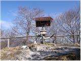
 | Bašelj - Gradišče (Pustinjak)
Gradišče or Pustinjak (also Gradišče above Bašlje) is an 871-metre-high peak located above the Belica stream, which in turn is below the 2132-met...
45 min |
 | Poljana (Završnica) - Mali vrh above Završnica
Mali vrh, which measures 863 metres, is one of the peaks of the Breznik Peci (also Reber) ridge, with the Zavrh valley to the north and the upper...
35 min |
 | Rebrca / Rechberg - Rokov vrh / Rochusberg
Rokov vrh is an 880 m high peak (according to some data 817 m) located between the settlements of Suha / Zauchen, Rebrca / Rechberg and Podkraj /...
40 min |
 | Gorenja vas - Jermanca (Jermancov grič)
Jermanca, on maps Jermanca hill, is a lookout point above Gorenjska vasje. In good weather, the summit offers a beautiful view of the peaks above...
55 min |
 | Podjuna / Jaunstein - Gora sv. Eme (Junska gora) / Hemmaberg (umik zaprti poti)
Gora sv. Eme is located south of the village of Podjuna / Jaunstein. The Church of St. Emma (Hema) Krška stands on the top and the ruins of forme...
55 min |
| Globasnica / Globasnitz - Gora sv. Eme (Junska gora) / Hemmaberg
Gora sv. Eme is located south of the village of Podjuna / Jaunstein. The Church of St. Emma (Hema) Krška stands on the top and the ruins of forme...
55 min |
 | Onek - Lovski vrh
Lovski vrh is a 830 m high peak located above the settlements of Onek and Mačkovec in the municipality of Kočevje. From the top, which is home to...
45 min |
 | Smiljan - Krčmar (Križev pot)
...
45 min |
 | Straßengel - Frauenkogel (pot št. 1)
...
45 min |