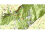
 | Bistriška planina - Dobrča
Dobrča is a 1634 m high mountain located between Begunje and Tržič. From the top, where the registration box with the stamp is located, we can se...
1 h 30 min |
 | Hibje - Dobrča (by road)
Dobrča is a 1634 m high mountain located between Begunje and Tržič. From the top, where the registration box with the stamp is located, we can se...
1 h 45 min |
 | Črni Kal - Blegoš (by road, via hut)
Blegoš is a 1562 m high mountain located between Selška and Poljane Sora. From the grassy summit, on which there is a stamp and a registration bo...
1 h 30 min |
 | Črni Kal - Blegoš (direct way)
Blegoš is a 1562 m high mountain located between Selška and Poljane Sora. From the grassy summit, on which there is a stamp and a registration bo...
1 h 10 min |
 | Črni kal - Blegoš (via Prva ravan)
Blegoš is a 1562 m high mountain located between Selška and Poljane Sora. From the grassy summit, on which there is a stamp and a registration bo...
1 h 20 min |
 | Rakitna - Krim
Krim is a 1107 m high mountain rising south of the Ljubljana Marshes. From the top of the mountain, where the mountain lodge and a number of tran...
2 h |
 | Bohinjsko sedlo - Možic (by Lajnar)
Možic is a 1602 m high peak located west of Soriška mountain pasture. It is at the highest point of the peak that there is an old military bunker...
1 h 30 min |
 | Hunting cottage (Davča) - Porezen
Porezen is a 1630 m high mountain located between Davča and Baška Grapa. From the top, where a large NOB monument stands, we have a beautiful vie...
1 h 45 min |
 | Podhočar - Porezen
Porezen is a 1630 m high mountain located between Davča and Baška Grapa. From the top, where a large NOB monument stands, we have a beautiful vie...
1 h 50 min |
 | Volovljek - Kranjska reber
Kranjska reber or Peak Kašna planina (1435 m) is a volcanic mountain. From the top, where the registration box with the stamp is located, we have...
1 h 20 min |
 | Črnivec - Kranjska reber
Kranjska reber or Peak Kašna planina (1435 m) is a volcanic mountain. From the top, where the registration box with the stamp is located, we have...
1 h 30 min |
 | Rateče - Ofen/Peč (by road)
Peč (also Tromeja), in Italian Monte Forno and in German Dreiländereck or Ofen, is a 1508 m high peak located on the tri-border between Slovenia,...
2 h |
 | Rateče - Ofen/Peč (footpath)
Peč (also Tromeja), in Italian Monte Forno and in German Dreiländereck or Ofen, is a 1508 m high peak located on the tri-border between Slovenia,...
1 h 40 min |
 | Korensko sedlo - Ofen/Peč
Peč (also Tromeja), in Italian Monte Forno and in German Dreiländereck or Ofen, is a 1508 m high peak located on the tri-border between Slovenia,...
2 h |
 | Rateče - Ofen/Peč (eastern path, past bivouac and on footpath)
Peč (also Tromeja), in Italian Monte Forno and in German Dreiländereck or Ofen, is a 1508 m high peak located on the tri-border between Slovenia,...
1 h 45 min |
| Rateče - Ofen/Peč (eastern path, past bivouac and on mule track)
Peč (also Tromeja), in Italian Monte Forno and in German Dreiländereck or Ofen, is a 1508 m high peak located on the tri-border between Slovenia,...
1 h 50 min |
 | Korensko sedlo - Ofen/Peč (on marked path)
Peč (also Tromeja), in Italian Monte Forno and in German Dreiländereck or Ofen, is a 1508 m high peak located on the tri-border between Slovenia,...
2 h |
 | Dom pod Storžičem - Bela peč
The mountain, which is known mainly by climbers, is located north of Storžič on the slopes of Konjščice. From the top there is a beautiful view o...
2 h |
| Dom pod Storžičem - Bela peč (via Javorniški preval)
The mountain, which is known mainly by climbers, is located north of Storžič on the slopes of Konjščice. From the top there is a beautiful view o...
2 h 5 min |
 | Na kopiš - Bela peč (via Spodnja and Zgornja Konjščica)
The mountain, which is known mainly by climbers, is located north of Storžič on the slopes of Konjščice. From the top there is a beautiful view o...
2 h |
 | Zgornja Sorica - Dravh
Dravh is a 1547 m high peak located between Sorica and Soriška mountain pasture. From the uncultivated summit, we have a beautiful view of Škofje...
1 h 30 min |
 | Zgornja Sorica - Lajnar
Lajnar is a 1549 m high mountain located north of Soriška mountain pasture. From the top, which is also the highest point of the ski resort, we h...
1 h 40 min |
 | Bohinjsko sedlo - Šavnik (by Lajnar)
Šavnik is a grassy peak located between the Soriška planina and Kobla ski resorts. From the summit, which has a registration box with a stamp, yo...
2 h |
 | Bohinjsko sedlo - Šavnik
Šavnik is a grassy peak located between the Soriška planina and Kobla ski resorts. From the summit, which has a registration box with a stamp, yo...
1 h 30 min |
 | Hunting cottage Vojkovo - Vojkova koča na Nanosu
Vojkova koča is located on the southern edge of the Nanoše plateau, close to Pleše, a peak that is clearly visible from the motorway. From the hu...
1 h 45 min |
 | Kramarica - Smrekovec (via Bukov stan)
Smrekovec is a volcanic mountain on the eastern edge of the Smrekov Mountains. The extensive grassy summit, on which stands a pyramid with a regi...
1 h 30 min |
| Kramarica - Smrekovec (by road)
Smrekovec is a volcanic mountain on the eastern edge of the Smrekov Mountains. The extensive grassy summit, on which stands a pyramid with a regi...
1 h 30 min |
| Ljubenske Rastke (Vrnivšek) - Smrekovec
Smrekovec is a volcanic mountain on the eastern edge of the Smrekov Mountains. The extensive grassy summit, on which stands a pyramid with a regi...
2 h |
 | Planina Vodol - Veliki Travnik
Veliki Travnik, or Turnovka as the locals call it, is located on the western edge of the Smrekov Mountains. From the top of the hill, where a woo...
2 h |
 | Predmeja - Kucelj na Čavnu
Kucelj is located on the southern slopes of Trnovo Forest, north-west of the Vipava valley. From the uncultivated summit on which the cross stand...
2 h |
 | Krnica - Kucelj na Čavnu (via Veliki Rob)
Kucelj is located on the southern slopes of Trnovo Forest, north-west of the Vipava valley. From the uncultivated summit on which the cross stand...
1 h 40 min |
 | Predmeja - Mali Modrasovec
Mali Modrasovec is a peak north of the house on Čavno in the Trnovo forest. On the top, surrounded by wods, there is a small house and a control ...
1 h 25 min |
 | Predmeja - Veliki Modrasovec
Veliki Modrasovec is located in the southern part of the Trnovo Forest near Predmeja. On the top of the hill is an old military building which yo...
1 h 35 min |
| Predmeja (tunnels) - Veliki Modrasovec
Veliki Modrasovec is located in the southern part of the Trnovo Forest near Predmeja. On the top of the hill is an old military building which yo...
1 h 50 min |
 | Predmeja - Mali Golak
Mali Golak is the highest of the Golaks. It was named not because it was the smallest but because it had the smallest mountain pasture. On the ma...
2 h |
 | Mala Lazna - Mali Golak
Mali Golak is the highest of the Golaks. It was named not because it was the smallest but because it had the smallest mountain pasture. On the ma...
1 h 25 min |
 | Kozarnice - Srednji Golak (via Mali Golak)
Srednji Golak is located between Mali and Veliki Golak on the plateau of the Trnovo Forest above Predmeja. The summit is covered with dwarf pines...
1 h 50 min |
 | Podmeja - Mrzlica
Mrzlica has become an extremely popular excursion point in the last few years, especially for visitors from the Savinjska Valley and Zasavje. At ...
1 h 15 min |
 | Podmeja - Mrzlica
Mrzlica has become an extremely popular excursion point in the last few years, especially for visitors from the Savinjska Valley and Zasavje. At ...
1 h 15 min |
 | Dom na Paškem Kozjaku - Basališče (Paški Kozjak)
Basališče is the highest peak of Paško Kozjak. There is a bench and a registration box at the top. Due to the forest, there is no view....
2 h |
 | St. John the Baptist on Ojstrica - Huhnerkogel/Košenjak
Huhnerkogel lies north of Dravograd and the River Drava on the border with neighbouring Austria. Huhnerkogel is accessible on foot or by car from...
1 h 30 min |
 | St. John the Baptist on Ojstrica - Huhnerkogel/Košenjak (via Bivak Piramida)
Huhnerkogel lies north of Dravograd and the River Drava on the border with neighbouring Austria. Huhnerkogel is accessible on foot or by car from...
2 h |
 | Jezero Sobote / Stausee Soboth - Huhnerkogel/Košenjak (po označeni poti)
Huhnerkogel lies north of Dravograd and the River Drava on the border with neighbouring Austria. Huhnerkogel is accessible on foot or by car from...
2 h |
 | Rifugio Pelizzo - Monte Mataiur/Matajur (via Fonte Skrila)
Monte Mataiur is a scenic mountain located on the border between Slovenia and Itali. From the top, you have a beautiful view of the Kobarid or Br...
1 h 15 min |
 | Rifugio Pelizzo - Monte Mataiur/Matajur (via Ledina)
Monte Mataiur is a scenic mountain located on the border between Slovenia and Itali. From the top, you have a beautiful view of the Kobarid or Br...
2 h |
 | Avsa - Mrzli vrh (on Matajur) (old path)
Mrzli vrh is a 1358-metre high peak located in the Matajur Mountains. From the top, where there is a viewing platform and a registration box with...
1 h 25 min |
 | Plajberški graben / Bleiberger Graben - Sinacher Gupf / Psinski vrh
Sinacher Gupf (on maps we mostly see the name Psinski vrh) / Sinacher Gupf is a peak located north of the main chain Karawanks, more precisely no...
1 h 35 min |
 | Strugarjach / Strugarje - Sinacher Gupf / Psinski vrh
Sinacher Gupf (on maps we mostly see the name Psinski vrh) / Sinacher Gupf is a peak located north of the main chain Karawanks, more precisely no...
1 h 30 min |
 | Windisch Bleiberg / Slovenji Plajberk - Singerberg / Žingarica
Singerberg is a peak located on the Austrian side of Karawanks above the village of Slovenji Plajberk / Windisch Bleiberg. The summit, which is p...
2 h |
 | Planinski dom Vrhe - Črni vrh (Čemšeniška planina)
Črni vrh is the highest peak of Čemšeniška mountain pasture and with a height of 1204 m it is the second highest peak in the Posavje - Zasavje hi...
1 h 30 min |
 | Ljubelj - Polna peč
Polna peč, also marked on maps as Ravna peč, is located above the Ljubljana Tunnel. From the top, which is somewhat precipitous, there is a beaut...
1 h 15 min |
 | Bučan - Polna peč
Polna peč, also marked on maps as Ravna peč, is located above the Ljubljana Tunnel. From the top, which is somewhat precipitous, there is a beaut...
1 h 30 min |
 | Črni Vrh (Grom) - Javornik above Črni vrh
Javornik is a forested peak located southeast of Črnji Vrho. In 1972, a lookout tower was erected on the summit, which reaches above the treetops...
1 h 10 min |
 | Platak - Snježnik (via grlo)
Snježnik is a scenic mountain in the western part of Gorski Kotar. The summit offers a beautiful view of the Kvarner islands, the Gulf of Reška, ...
1 h 30 min |
| Platak - Snježnik (via crest)
Snježnik is a scenic mountain in the western part of Gorski Kotar. The summit offers a beautiful view of the Kvarner islands, the Gulf of Reška, ...
1 h 30 min |
 | Bistriška planina - Šentanski vrh
Šentanski vrh, located in the Dobrča mountain range, only 5 minutes away from the main peak, offers a beautiful view of the central Karawanks, th...
1 h 35 min |
 | Preval Vrh Ravni - Kojca
Kojca is a scenic peak rising south of Baška Grape. The hay pile on the top offers a beautiful view of the Lower Bohinj Mountains, the Škofjelošk...
1 h 20 min |
 | Podkraj - Sveti Duh (Hrušica)
The Sveti Duh Church is located just a few metres below the eponymous peak on the slopes of the forested Hrušice, a mountain range between Col, L...
1 h 15 min |
 | Koča na planini Stador - Kobilja glava
Kobilja glava is a 1475 m high peak located east of Tolmin. From the top with a cross, we have a beautiful view of the Krn, the Lower Bohinj Moun...
1 h 15 min |
 | Koprivna (Kumer) - Topitza
Topitza, or Topitza in German, is a 1649 m high peak located northeast of Železna Kapla. From the summit, on which the cross stands, we have a be...
2 h 10 min |
| Podkraj - Srednja gora (Hrušica) (east path)
Srednja gora is a 1275 m high peak located in the central part of the forested Hrušice. The peak is covered with forest, and just a few minutes w...
1 h 30 min |
| Podkraj - Srednja gora (Hrušica) (west path)
Srednja gora is a 1275 m high peak located in the central part of the forested Hrušice. The peak is covered with forest, and just a few minutes w...
1 h 45 min |
 | Podkraj - Streliški vrh (Hrušica) (east path)
Streliški vrh is a 1266 m high mountain located in the central part of the forested Hrušice. From the top, which is partly covered with forest, w...
1 h 30 min |
| Podkraj - Streliški vrh (Hrušica) (west path)
Streliški vrh is a 1266 m high mountain located in the central part of the forested Hrušice. From the top, which is partly covered with forest, w...
1 h 20 min |
 | Ravne - Cerk
At 1192 m, Cerk is the highest peak of Borovška Gora, a mountain range located between the Kolpa River valley and Goteniškje Snežnik. From the to...
1 h 30 min |
 | Fusine Laghi - Monte Coppa
Kopa (also Kopje on some maps) or after ital. Monte Coppa is a 1496 metres high peak located on the Italian side of the Karavanke Mountains. The ...
2 h |
 | Dom na Paškem Kozjaku - Štrukljev vrh
Štrukljev vrh is one of the three main peaks of Paški Kozjak, a 10 km long, narrow and very steep limestone mountain range between the Paka and H...
1 h 30 min |
 | Avsa - Srednji vrh (on Matajur) (old path)
Srednji vrh is a 1320-metre high grassy peak located in the Matajur mountain range. The summit, which is a take-off point for paragliders, offers...
1 h 20 min |
 | St. John the Baptist on Ojstrica - Kozji vrh (at Košenjak)
Kozji vrh is a 1383-metre-high peak located above Pernice, and its height makes it the highest peak in the municipality of Muta....
1 h 35 min |
 | Parking Rote Wand (Tyrnau) - Rote Wand (via saddle Bucheben)
Rote Wand is a 1505 m high mountain in the Graz mountain range in Styria, Austria. It is named "Rote Wand" (red wall) after the southeast-facing ...
2 h |
 | Mönichkirchen - Steinerne Stiege
Steinerne Stiege is a less prominent peak in the Wechsell mountain range....
1 h 35 min |
 | St. Vinzenz (St. Vinzenz) - Dreieckkogel
...
1 h 35 min |
 | Planinski dom Orlove stine - Svilaja (mimo Umaca)
...
2 h |
 | Straßegg - Hochschlag
...
1 h 45 min |