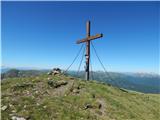
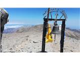
 | Tomčeva koča na Poljški planini - Begunjščica
Begunjščica is a mountain range in Karawanks east of Stol. The highest peak is Veliki vrh, which at over 2000m offers a beautiful view of central...
2 h 50 min |
 | Valvasorjev dom pod Stolom - Hochstuhl/Stol (Zabreška way)
At 2236 m, Stol is the highest peak in the Karavanke Mountains. From the summit, which has a registration box and a stamp, we have a beautiful vi...
3 h 20 min |
 | Valvasorjev dom pod Stolom - Hochstuhl/Stol (Žirovniška way)
At 2236 m, Stol is the highest peak in the Karavanke Mountains. From the summit, which has a registration box and a stamp, we have a beautiful vi...
3 h |
 | Razpotje Vragovec - Hochstuhl/Stol (via Zabreška planina)
At 2236 m, Stol is the highest peak in the Karavanke Mountains. From the summit, which has a registration box and a stamp, we have a beautiful vi...
3 h |
 | Globoka dolina - Veliki vrh (Košuta)
Veliki vrh, with a height of 2088 m, is the westernmost two-thousander in the longest Slovenian ridge - the Košuta. From the summit, where there ...
3 h |
 | Šport hotel - Debela peč
Debela peč is a 2014 m high mountain that rises steeply above the Krma valley on one side and descends gently towards the vast Pokljuka forests o...
3 h 30 min |
 | Rudno polje - Debela peč
Debela peč is a 2014 m high mountain that rises steeply above the Krma valley on one side and descends gently towards the vast Pokljuka forests o...
3 h 15 min |
 | Dom pod Storžičem - Storžič (through southwest groove)
Storžič is a 2132 m high mountain located in the western part of the Kamink Savinja Alps. From the top with a cross there are beautiful views of ...
3 h 50 min |
 | Vrh Bače - Črna prst
On the northern slope of the Črna prst summit head, you can see the black soil from which the mountain takes its name. Črna prst is known for its...
3 h 10 min |
 | Bohinjsko sedlo - Črna prst
On the northern slope of the Črna prst summit head, you can see the black soil from which the mountain takes its name. Črna prst is known for its...
5 h |
 | Mašun - Snežnik
Snežnik or Veliki Snežnik is the highest peak in the near and far surroundings with a height of 1796 m. It offers a beautiful view over most of S...
4 h |
 | Bukovnik - Velika Raduha (via Durce)
At 2062 m, Velika Raduha is the highest peak of Raduha, a mountain range rising steeply to the east of Robanov Kot. From the summit, which has a ...
2 h 50 min |
 | Radušnik - Velika Raduha
At 2062 m, Velika Raduha is the highest peak of Raduha, a mountain range rising steeply to the east of Robanov Kot. From the summit, which has a ...
3 h 10 min |
| Planina Kosmačeve Rastke - Velika Raduha
At 2062 m, Velika Raduha is the highest peak of Raduha, a mountain range rising steeply to the east of Robanov Kot. From the summit, which has a ...
2 h 55 min |
 | Planina Blato - Mala Tičarica (via Štapce)
Mala Tičarica is a very scenic mountain above the Double Triglav Lake. From the top, you can enjoy a beautiful view towards the cottage at Trigla...
3 h 30 min |
 | End of road on Vogar - Mala Tičarica (via Štapce)
Mala Tičarica is a very scenic mountain above the Double Triglav Lake. From the top, you can enjoy a beautiful view towards the cottage at Trigla...
3 h 35 min |
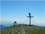
 | Planina pod Golico - Kahlkogel/Golica (via Suha saddle)
Kahlkogel is an unvegetated peak located north of Jesenice. From the top, which has a registration box, there is a beautiful view of the western ...
3 h |
 | Šport hotel - Brda (east path)
Brda is a scenic peak located between Pokljuka and Krma. From the top, where a stamp is attached to a metal pole, we have a beautiful view toward...
3 h 15 min |
 | Rudno polje - Brda (east path)
Brda is a scenic peak located between Pokljuka and Krma. From the top, where a stamp is attached to a metal pole, we have a beautiful view toward...
3 h |
 | Rudno polje - Brda (west path)
Brda is a scenic peak located between Pokljuka and Krma. From the top, where a stamp is attached to a metal pole, we have a beautiful view toward...
3 h |
 | Ljubelj - Srednji vrh (above Završnica) (on the slope of Vrtača)
Srednji vrh is a scenic and dwarf pines mountain located between Stol, Vertatscha and Begunjščica. From the summit, which descends precipitously ...
3 h |
 | Valvasorjev dom - Prešernova koča na Stolu (Zabreška way)
Prešernova koča na Stolu, is located just a few metres below the summit of the 2198 m high Mali Stol. From the hut or the nearby Mali Stol, we ha...
3 h 5 min |
 | Ski hotel Vogel - Rodica
The mountain is located above Bohinj in the Lower Bohinj Mountains. From the top there is a beautiful view of Julian Alps and Škofjeloško and the...
3 h |
 | Markova raven - Vrh Korena (marked way)
Vrh Korena is located between Zvoh and Kalški greben near the Krvavški ski slopes. From the top there is a beautiful view towards the highest pea...
3 h 15 min |
 | Kriška planina - Kalški greben (via planina Koren)
Kalški greben is 2224 m high and is the highest peak of the eponymous ridge. The summit, which has a registration box and a stamp, offers a beaut...
3 h 45 min |
| Dom na Gospincu - Kalški greben (via Dolga Njiva)
Kalški greben is 2224 m high and is the highest peak of the eponymous ridge. The summit, which has a registration box and a stamp, offers a beaut...
3 h 20 min |
| Planina Jezerca - Kalški greben (via planina Koren)
Kalški greben is 2224 m high and is the highest peak of the eponymous ridge. The summit, which has a registration box and a stamp, offers a beaut...
4 h |
 | Markova raven - Kompotela (marked way)
Kompotela is a peak near Mokrica and the summit of Koren. The grass and dwarf pines covered peak has a beautiful view towards Grintovec, Skuta, B...
3 h |
 | Markova raven - Mokrica (marked way)
Mokrica is a scenic peak to the east of Kompotele. On the top, which is partly covered with dwarf pines, there is a registration book....
3 h 30 min |
| Planina Jezerca - Mokrica (via Kompotela)
Mokrica is a scenic peak to the east of Kompotele. On the top, which is partly covered with dwarf pines, there is a registration book....
3 h |
 | Šport hotel - Debeli vrh above Lipanca
Debeli vrh is a 1962 m high mountain located in a ridge of mountains rising steeply above the Krma valley. From the top, where a stamp is attache...
3 h 15 min |
 | Jekarica - Mali Grintovec
Mali Grintovec is a lookout mountain located to the east of Storžiča. From the top, where there is a registration box, a stamp and a nice bench, ...
2 h 50 min |
 | Planina Kuhinja - Batognica (via jezero v Lužnici)
Batognica is a 2164 m high mountain, which was affected by the Mine War during World War I. Remnants of the mine war between the Italians and the...
4 h |
 | Valvasorjev dom pod Stolom - Potoški Stol
Potoški Stol is located between Hochstuhl and Weinasch on the border with Austria. Just a few metres below the grassy peak, a cross is erected. T...
3 h 5 min |
 | Kurnikovo sedlo - Hochobir (Ojstrc) (footpath)
Hochobir (Hochobir) is the highest peak of a small mountain range called Obir. It is located west of Železna Kapla (Eisenkappel) on the Austrian ...
3 h 5 min |
| Zell-Schaida - Hochobir (Ojstrc)
Hochobir (Hochobir) is the highest peak of a small mountain range called Obir. It is located west of Železna Kapla (Eisenkappel) on the Austrian ...
3 h |
 | Planina Kuk - Vogel (via Globoko)
When you hear the name Vogel, many people first think of the Vogel ski resort, which is located near the peak of the same name. From the north si...
3 h 30 min |
 | Koutschitz Alm/Kočiška planina - Poludnig/Poludnik
Poludnig is located in the eastern part of the Carnic Alps. As there is no higher peak in the vicinity, Poludnik/Poludnig offers a very nice view...
3 h |
 | Waldheim Hütte - Zirbitzkogel (Seetal Alps) (via Wildsee)
At 2396m, Zirbitzkogel is the highest peak in the Seetaler Alps. The summit, on which stands a cross and a viewing platform, offers a beautiful v...
3 h 22 min |
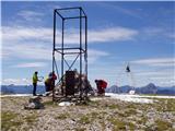
 | Tonnerhütte - Scharfes Eck (Seetal Alps)
Scharfes Eck is the peak on which the Austrian meteorological radar station stands. The unpopular peak offers a beautiful view of the neighbourin...
3 h |
 | Salzstiegelhaus - Großenberg (Packalpe) (via Ameringkogel)
Großenberg is the northernmost of the two-thousanders in the Packalp chain. The vast grassy summit on which the triple cross stands offers a beau...
3 h |
| Salzstiegelhaus - Großenberg (Packalpe)
Großenberg is the northernmost of the two-thousanders in the Packalp chain. The vast grassy summit on which the triple cross stands offers a beau...
2 h 55 min |
 | Nassfeld - Monte Cavallo / Rosskofel (via Sella di Aip / Rudnig sattel)
The Horse Spike / Monte Cavallo di Pontebba / Rosskofel is a 2240 m high and very scenic mountain in the Carnic Alps main ridge in the Wetlands /...
4 h |
 | Koprein-Petzen - Petzen (Kordeschkopf) (Peca (Kordeževa glava))
Kordeževa glava, better known as Peca is the highest summit in the mountain chain Peca. It is located on the border with Austria above Mežiška do...
4 h |
 | Rudnik v Topli - Petzen (Kordeschkopf) (Peca (Kordeževa glava)) (via hut, easy)
Kordeževa glava, better known as Peca is the highest summit in the mountain chain Peca. It is located on the border with Austria above Mežiška do...
3 h 30 min |
| Pod Peco / Koprein-Petzen - Petzen (Kordeschkopf) (Peca (Kordeževa glava)) (slovenska pot)
Kordeževa glava, better known as Peca is the highest summit in the mountain chain Peca. It is located on the border with Austria above Mežiška do...
3 h 50 min |
| Koprivna (Kumer) - Petzen (Kordeschkopf) (Peca (Kordeževa glava))
Kordeževa glava, better known as Peca is the highest summit in the mountain chain Peca. It is located on the border with Austria above Mežiška do...
3 h 25 min |
 | Koča na Pikovem - Petzen (Kordeschkopf) (Peca (Kordeževa glava)) (via saddle Vrh šteng and on easy path)
Kordeževa glava, better known as Peca is the highest summit in the mountain chain Peca. It is located on the border with Austria above Mežiška do...
4 h 15 min |
 | Spodnje Sleme - Govca (Olševa)
Govca is the highest peak of the Olševa, a mountain range rising above Koprivna, Solčava and Remschenik (Remschenik / Remschenig is a valley on t...
3 h |
 | Pod Peco / Koprein-Petzen - Govca (Olševa) (via Kumer)
Govca is the highest peak of the Olševa, a mountain range rising above Koprivna, Solčava and Remschenik (Remschenik / Remschenig is a valley on t...
4 h 30 min |
| Mountain hut on farm Kumer - Govca (Olševa)
Govca is the highest peak of the Olševa, a mountain range rising above Koprivna, Solčava and Remschenik (Remschenik / Remschenig is a valley on t...
3 h 45 min |
 | Waldrast - Großer Speikkogel (Koralpe) (via Großhöllerhütte)
At 2140m, Großer Speikkogel is the highest peak of the Golice/Koralpe, a mountain range located east of Wolfsberg. From the top, where a cross an...
3 h 45 min |
 | parking below Weinebene - Großer Speikkogel (Koralpe) (via Grünangerhütte)
At 2140m, Großer Speikkogel is the highest peak of the Golice/Koralpe, a mountain range located east of Wolfsberg. From the top, where a cross an...
3 h 10 min |
 | Lading - Ladinger Spitze (Saualpe) (via Ladinger Hütte)
Ladinger Spitze, or Ladinger Spitze in German, is the highest peak of the mountain pasture Sow/Saualpe at 2079m. From the summit on which the cro...
3 h |
 | Klippitztörl - Ladinger Spitze (Saualpe) (via Geierkogel and Gertrusk)
Ladinger Spitze, or Ladinger Spitze in German, is the highest peak of the mountain pasture Sow/Saualpe at 2079m. From the summit on which the cro...
4 h 10 min |
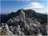
 | Goldberg - Jaukenstöckl
Jaukenstöckl is a 2209m high peak located on the western side of the Jauken lookout ridge. From the top, where the statue of St. Mary stands, the...
3 h 45 min |
 | Goldberg - Jaukenhöhe
Jaukenhöhe is a little visited peak in the Jauken ridge. It is located to the west of Torkofl, which at 2276m is the highest in the ridge. The gr...
3 h 45 min |
 | Etrachsee - Bauleiteck
Bauleiteck is a scenic peak located in the eastern part of the Schladminger Taueren mountain group. From the summit on which the cross stands, yo...
3 h 15 min |
 | Rudno polje - Okroglež
Okroglež is a dwarf pines vegetated peak located between Debela peč and Brdy. From the summit, which has a stamp (without a registration book), w...
2 h 55 min |
 | Koprivna (Kumer) - Wackendorfer Spitze
Wackendorfer Spitze is the northernmost two-thousander in the Pec mountain range. From this inconspicuous peak, in fine weather, we can enjoy a m...
2 h 55 min |
 | Jakobe - Feistritzer Spitze (easy path)
Feistritzer Spitze is a 2113 m high peak located on the Austrian side of Pec. From the top on which the cross stands, you have a beautiful view o...
3 h 45 min |
| Koprivna (Kumer) - Feistritzer Spitze (Austrian path)
Feistritzer Spitze is a 2113 m high peak located on the Austrian side of Pec. From the top on which the cross stands, you have a beautiful view o...
2 h 55 min |
 | Koprivna (Kumer) - Feistritzer Spitze (slovenska pot)
Feistritzer Spitze is a 2113 m high peak located on the Austrian side of Pec. From the top on which the cross stands, you have a beautiful view o...
3 h 40 min |
 | Koprein-Petzen - Končnikov vrh
Končnikov vrh is a 2109 m high mountain located in the central part of Pec. The grassy peak offers a beautiful view along the Pec ridge and the m...
3 h 15 min |
 | Pod Peco/Koprein-Petzen - Končnikov vrh (slovenska pot)
Končnikov vrh is a 2109 m high mountain located in the central part of Pec. The grassy peak offers a beautiful view along the Pec ridge and the m...
3 h 15 min |
| Koprivna (Kumer) - Končnikov vrh (slovenska pot)
Končnikov vrh is a 2109 m high mountain located in the central part of Pec. The grassy peak offers a beautiful view along the Pec ridge and the m...
2 h 55 min |
 | Plockenpass - Creta di Collinetta / Cellon
Creta di Collinetta/Cellon is a 2238 m high mountain located west of the Plockenpass. From the top with a cross, you have a beautiful view of the...
3 h |
 | Planina Ravne - Mala Ojstrica (via Dolga trata)
Mala Ojstrica is a featureless peak located between Ojstrica, Molička mountain pasture and Korošica. From the top, where there is a registration ...
3 h 45 min |
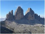 | Piano Fiscalino / Fischleinboden - Sasso di Sesto / Sextnerstein
Sasso di Sesto is a 2,539-metre-high peak located in the Dolomites di Sesto Natural Park. Easily accessible, the peak offers outstanding views of...
3 h 30 min |
 | Bad Kleinkirchheim - Wöllaner Nock
Wöllaner Nock is a 2145 m high peak located south of the ski resort and town of Bad Kleinkirchheim. The spacious summit, on which a large cross s...
3 h 45 min |
| Bad Kleinkirchheim - Wöllaner Nock (by road)
Wöllaner Nock is a 2145 m high peak located south of the ski resort and town of Bad Kleinkirchheim. The spacious summit, on which a large cross s...
4 h 15 min |
 | Bad Kleinkirchheim - Kaiseburg
Kaiseburg is a scenic peak located directly above the Bad Kleinkirchheim ski area. From the top, where the cross stands, you can enjoy a beautifu...
3 h 25 min |
 | Bad Kleinkirchheim - Kaiseburg (by road)
Kaiseburg is a scenic peak located directly above the Bad Kleinkirchheim ski area. From the top, where the cross stands, you can enjoy a beautifu...
3 h 55 min |
 | Colfosco - Sas Ciampac
Sas Ciampac is a 2,672-metre peak in the Puez mountain group. From the top, where a small wooden cross stands, you have a beautiful view of the P...
3 h 30 min |
 | Sportgastein - Greilkopf (via Hagener Hütte)
Greilkopf is a 2581 m high mountain in Ankogel mountain group in Hohe Tauern in Austria near Malnitz. Greilkopf is a popular winter destination. ...
3 h 45 min |
 | Plöckenhaus - Polinik (path 403)
Polinik is a 2332 meter high mountain in the Carnic Alps in Austria near the high mountain pass with Italy named Plöckenpass.A summit cross is pl...
3 h 15 min |
 | Turrach - Eisenhut
Eisenhut is the highest peak in Gurktal Alps with a height of 2441 metres, the Alps stretching in the Krka / Gurk river basin, descending northwa...
4 h 30 min |
 | Turracher Höhe - Straßburger Spitz
Straßburger Spitz is a 2404 metre high peak located between Eisenhut (2441 m) and Wintertalernock (2394 m). From the top, where there is a wooden...
4 h 45 min |
 | Turrach - Straßburger Spitz
Straßburger Spitz is a 2404 metre high peak located between Eisenhut (2441 m) and Wintertalernock (2394 m). From the top, where there is a wooden...
4 h |
 | Turracher Höhe - Wintertalernock
Wintertalernock is a 2394 m high peak located south-east of the highest peak of Gurktal Alps, Eisenhut. The summit, on which the cross stands, of...
5 h |
| Turrach - Wintertalernock
Wintertalernock is a 2394 m high peak located south-east of the highest peak of Gurktal Alps, Eisenhut. The summit, on which the cross stands, of...
4 h 15 min |
 | Planina Zajzera - Krniška glavica / Jof di Sompdogna (path 639 and 652)
Krniška glavica (Jof di Sompdogna) is a 1,889-metre-high peak in the Western Julian Alps, north of Jôf di Montasioa. There is a cross on the look...
3 h 10 min |
 | Sella di Razzo - Clapsavon (via 210)
Clapsavon is a 2462 m high mountain in Carnic Alps in Italy, and it is situated just short of 1 hour hiking distance to the west from Monte Biver...
3 h |
 | Nida - Timios Stavros / Psiloritis (Kreta)
Timios Stavros, 2456 m, is the highest peak on Crete island in Greece (and also among all the other Greek islands), and with highest topographica...
4 h 15 min |
 | Pass Lius above Ligosullo - Tersadia (from Ligosullo)
Tersadia is a mountain in the heart of the Carnian Mountains, just far enough away from its higher neighbours to provide an excellent vantage poi...
3 h |