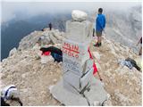
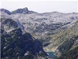
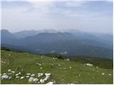
 | V Koncu - Grintovec (via Streha)
Grintovec is the highest peak in the Kamnik and Savinja Alps. It is located above the valley of Kamniška Bistrica, Suhi dol and above the valley ...
4 h 30 min |
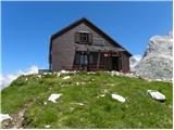
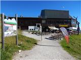
 | The Krma Valley - Triglavski dom na Kredarici
Triglavski dom na Kredarici is Slovenia's highest mountain hut. It is open all year round but only on an emergency basis out of season. From the ...
5 h |
 | Dom v Dragi - Begunjščica (via Roblekov dom)
Begunjščica is a mountain range in Karawanks east of Stol. The highest peak is Veliki vrh, which at over 2000m offers a beautiful view of central...
4 h 20 min |
 | Ljubelj - Hochstuhl/Stol (lower path)
At 2236 m, Stol is the highest peak in the Karavanke Mountains. From the summit, which has a registration box and a stamp, we have a beautiful vi...
4 h 50 min |
 | Tinčkova koča - Hochstuhl/Stol (via Smokuška planina)
At 2236 m, Stol is the highest peak in the Karavanke Mountains. From the summit, which has a registration box and a stamp, we have a beautiful vi...
4 h 15 min |
 | Dom Trilobit - Hochstuhl/Stol
At 2236 m, Stol is the highest peak in the Karavanke Mountains. From the summit, which has a registration box and a stamp, we have a beautiful vi...
4 h 30 min |
 | Poljana (Završnica) - Hochstuhl/Stol (Žirovniška pot)
At 2236 m, Stol is the highest peak in the Karavanke Mountains. From the summit, which has a registration box and a stamp, we have a beautiful vi...
4 h 20 min |
 | Poljana (Završnica) - Hochstuhl/Stol (Zabreška pot)
At 2236 m, Stol is the highest peak in the Karavanke Mountains. From the summit, which has a registration box and a stamp, we have a beautiful vi...
4 h 40 min |
 | Razpotje Vragovec - Hochstuhl/Stol (via Zabreška planina)
At 2236 m, Stol is the highest peak in the Karavanke Mountains. From the summit, which has a registration box and a stamp, we have a beautiful vi...
3 h |
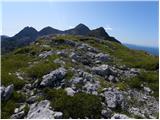
 | Matizovec - Veliki vrh (Košuta)
Veliki vrh, with a height of 2088 m, is the westernmost two-thousander in the longest Slovenian ridge - the Košuta. From the summit, where there ...
3 h 20 min |
| Globoka dolina - Veliki vrh (Košuta)
Veliki vrh, with a height of 2088 m, is the westernmost two-thousander in the longest Slovenian ridge - the Košuta. From the summit, where there ...
3 h |
 | Podljubelj - Veliki vrh (Košuta) (via Matizovec)
Veliki vrh, with a height of 2088 m, is the westernmost two-thousander in the longest Slovenian ridge - the Košuta. From the summit, where there ...
4 h 15 min |
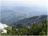
 | Laško - Storžič (via Javornik)
Storžič is a 2132 m high mountain located in the western part of the Kamink Savinja Alps. From the top with a cross there are beautiful views of ...
4 h 10 min |
 | Povlje - Storžič (through southwest groove)
Storžič is a 2132 m high mountain located in the western part of the Kamink Savinja Alps. From the top with a cross there are beautiful views of ...
4 h |
| Dom pod Storžičem - Storžič (through southwest groove)
Storžič is a 2132 m high mountain located in the western part of the Kamink Savinja Alps. From the top with a cross there are beautiful views of ...
3 h 50 min |
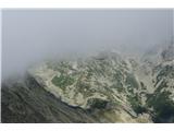
 | Ravne - Črna prst (via Orožnova koča)
On the northern slope of the Črna prst summit head, you can see the black soil from which the mountain takes its name. Črna prst is known for its...
3 h 5 min |
| Ravne - Črna prst (via planina za Črno goro)
On the northern slope of the Črna prst summit head, you can see the black soil from which the mountain takes its name. Črna prst is known for its...
3 h 25 min |
 | Petrovo Brdo - Črna prst
On the northern slope of the Črna prst summit head, you can see the black soil from which the mountain takes its name. Črna prst is known for its...
4 h 40 min |
 | Bistra - Velika Raduha
At 2062 m, Velika Raduha is the highest peak of Raduha, a mountain range rising steeply to the east of Robanov Kot. From the summit, which has a ...
4 h 55 min |
 | Radušnik - Velika Raduha
At 2062 m, Velika Raduha is the highest peak of Raduha, a mountain range rising steeply to the east of Robanov Kot. From the summit, which has a ...
3 h 10 min |
 | Planina Kosmačeve Rastke - Velika Raduha
At 2062 m, Velika Raduha is the highest peak of Raduha, a mountain range rising steeply to the east of Robanov Kot. From the summit, which has a ...
2 h 55 min |
 | Planina Kuhinja - Krn
At 2244 m, Krn is the highest peak of the Krn Mountains, a mountain range that rises steeply above the central part of the Soča River. From the s...
3 h 15 min |
 | Dom v Lepeni - Krn
At 2244 m, Krn is the highest peak of the Krn Mountains, a mountain range that rises steeply above the central part of the Soča River. From the s...
5 h |
| Koča na planini Kuhinja - Krn
At 2244 m, Krn is the highest peak of the Krn Mountains, a mountain range that rises steeply above the central part of the Soča River. From the s...
3 h 10 min |
 | Planina Blato - Mala Tičarica (via Štapce)
Mala Tičarica is a very scenic mountain above the Double Triglav Lake. From the top, you can enjoy a beautiful view towards the cottage at Trigla...
3 h 30 min |
| Tolminske Ravne - Tolminski Kuk (via Planina Kal)
Tolminski Kuk is the highest peak of the Lower Bohinj Mountains. The summit, which has a registration box, offers a very nice view. From the top ...
4 h |
 | Zadnjica - Pogačnikov dom na Kriških podih
The hut is located on a panoramic hill in the Kriški Podi above Trenta. The hut, which is open in the summer season, also has a large winter room...
4 h |
 | Zadnjica - Zasavska koča na Prehodavcih
Zasavska koča na Prehodavcih is located on a scenic peak above the Triglav Lakes Valley. The hut, which is open in the summer season, offers a be...
4 h 15 min |
 | Planina Blato - Zasavska koča na Prehodavcih (Za Kopico)
Zasavska koča na Prehodavcih is located on a scenic peak above the Triglav Lakes Valley. The hut, which is open in the summer season, offers a be...
5 h |
 | Dom Trilobit - Barentaler Kotschna/Struška
Barentaler Kotschna is a small mountain range located between Stolo or Belščica and Golica. From Veliki vrh, as the highest peak of the mountain ...
3 h |
 | Dovje - Frauenkogel/Dovška Baba
Frauenkogel is an 1891 m high peak located on the border ridge between Slovenia and Austria. The summit, which has a registration box and a stamp...
3 h |
 | Poljana (Završnica) - Prešernova koča na Stolu (Žirovniška pot)
Prešernova koča na Stolu, is located just a few metres below the summit of the 2198 m high Mali Stol. From the hut or the nearby Mali Stol, we ha...
4 h 5 min |
 | Poljana (Završnica) - Prešernova koča na Stolu (Zabreška pot)
Prešernova koča na Stolu, is located just a few metres below the summit of the 2198 m high Mali Stol. From the hut or the nearby Mali Stol, we ha...
4 h 25 min |
 | Grant - Rodica
The mountain is located above Bohinj in the Lower Bohinj Mountains. From the top there is a beautiful view of Julian Alps and Škofjeloško and the...
3 h 30 min |
| Stržišče - Rodica
The mountain is located above Bohinj in the Lower Bohinj Mountains. From the top there is a beautiful view of Julian Alps and Škofjeloško and the...
4 h 15 min |
 | Markova raven - Vrh Korena (marked way)
Vrh Korena is located between Zvoh and Kalški greben near the Krvavški ski slopes. From the top there is a beautiful view towards the highest pea...
3 h 15 min |
 | Markova raven - Kalški greben (on marked path)
Kalški greben is 2224 m high and is the highest peak of the eponymous ridge. The summit, which has a registration box and a stamp, offers a beaut...
4 h 30 min |
 | Markova raven - Kompotela (marked way)
Kompotela is a peak near Mokrica and the summit of Koren. The grass and dwarf pines covered peak has a beautiful view towards Grintovec, Skuta, B...
3 h |
 | Markova raven - Mokrica (marked way)
Mokrica is a scenic peak to the east of Kompotele. On the top, which is partly covered with dwarf pines, there is a registration book....
3 h 30 min |
 | Koča pri Savici - Lanževica (via Bogatinsko sedlo)
Lanževica is a 2003 m high peak located between Bogatinsko sedlo and Oslovo Stub. The summit, on which the remains of the former Rapallo border s...
5 h |
| Koča pri Savici - Lanževica (via Lepa Komna)
Lanževica is a 2003 m high peak located between Bogatinsko sedlo and Oslovo Stub. The summit, on which the remains of the former Rapallo border s...
5 h |
 | Pod Zjabci - Lanževica (via Lepa Komna)
Lanževica is a 2003 m high peak located between Bogatinsko sedlo and Oslovo Stub. The summit, on which the remains of the former Rapallo border s...
5 h |
| Dom v Lepeni - Lanževica (via Bogatinsko sedlo)
Lanževica is a 2003 m high peak located between Bogatinsko sedlo and Oslovo Stub. The summit, on which the remains of the former Rapallo border s...
5 h |
 | Koča pri Savici - Mahavšček (via planina Govnjač)
Mahavšček or Big Bogatin is a 2008 m high mountain located on the north-western outskirts of the Lower Bohinj Mountains. From the top, where ther...
5 h |
 | Mojstrana - Sleme
The mountain is located between Mojstrana and Kukova Spica. The top is grassy and has a very nice view towards Kukova Spica. From the top there i...
4 h 15 min |
 | Laško - Mali Grintovec (via Bašeljski vrh)
Mali Grintovec is a lookout mountain located to the east of Storžiča. From the top, where there is a registration box, a stamp and a nice bench, ...
3 h 30 min |
| Jekarica - Mali Grintovec
Mali Grintovec is a lookout mountain located to the east of Storžiča. From the top, where there is a registration box, a stamp and a nice bench, ...
2 h 50 min |
 | MHE Zabukovec - Mali Grintovec
Mali Grintovec is a lookout mountain located to the east of Storžiča. From the top, where there is a registration box, a stamp and a nice bench, ...
3 h 50 min |
| Laško - Mali Grintovec (via Dom na Kališču)
Mali Grintovec is a lookout mountain located to the east of Storžiča. From the top, where there is a registration box, a stamp and a nice bench, ...
3 h 15 min |
 | Planina Kuhinja - Batognica (via jezero v Lužnici)
Batognica is a 2164 m high mountain, which was affected by the Mine War during World War I. Remnants of the mine war between the Italians and the...
4 h |
 | Planina Blato - Mala Zelnarica (Za Kopico)
Mala Zelnarica is a 2310 m high peak located between the Triglav Lakes Valley and the Za Kopica Valley. The summit, which has a registration box ...
4 h 30 min |
 | Mojstrana - Vrtaški vrh
Vrtaški vrh is a scenic mountain overloking the Vrata valley. From the grassy summit, which is covered around and around with dwarf pines, there ...
3 h 40 min |
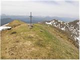
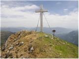
 | Dom Trilobit - Potoški Stol (via Rida)
Potoški Stol is located between Hochstuhl and Weinasch on the border with Austria. Just a few metres below the grassy peak, a cross is erected. T...
4 h |
 | Poljana (Završnica) - Potoški Stol (Žirovniška pot)
Potoški Stol is located between Hochstuhl and Weinasch on the border with Austria. Just a few metres below the grassy peak, a cross is erected. T...
4 h 25 min |
 | Kurnikovo sedlo - Hochobir (Ojstrc) (footpath)
Hochobir (Hochobir) is the highest peak of a small mountain range called Obir. It is located west of Železna Kapla (Eisenkappel) on the Austrian ...
3 h 5 min |
| Zell-Schaida - Hochobir (Ojstrc)
Hochobir (Hochobir) is the highest peak of a small mountain range called Obir. It is located west of Železna Kapla (Eisenkappel) on the Austrian ...
3 h |
 | Tolminske Ravne - Vogel (on mule track)
When you hear the name Vogel, many people first think of the Vogel ski resort, which is located near the peak of the same name. From the north si...
3 h 30 min |
| Tolminske Ravne - Vogel (on mule track and over Globoko)
When you hear the name Vogel, many people first think of the Vogel ski resort, which is located near the peak of the same name. From the north si...
4 h 15 min |
 | Rudnik v Topli - Petzen (Kordeschkopf) (Peca (Kordeževa glava)) (via hut, easy)
Kordeževa glava, better known as Peca is the highest summit in the mountain chain Peca. It is located on the border with Austria above Mežiška do...
3 h 30 min |
 | Koprivna (Kumer) - Petzen (Kordeschkopf) (Peca (Kordeževa glava))
Kordeževa glava, better known as Peca is the highest summit in the mountain chain Peca. It is located on the border with Austria above Mežiška do...
3 h 25 min |
 | Podpeca (Mitnek) - Petzen (Kordeschkopf) (Peca (Kordeževa glava)) (easy path)
Kordeževa glava, better known as Peca is the highest summit in the mountain chain Peca. It is located on the border with Austria above Mežiška do...
4 h 15 min |
 | Koča na Pikovem - Petzen (Kordeschkopf) (Peca (Kordeževa glava)) (via saddle Vrh šteng and on easy path)
Kordeževa glava, better known as Peca is the highest summit in the mountain chain Peca. It is located on the border with Austria above Mežiška do...
4 h 15 min |
| Topla (Burjak) - Petzen (Kordeschkopf) (Peca (Kordeževa glava)) (via Mala Peca and on easy path)
Kordeževa glava, better known as Peca is the highest summit in the mountain chain Peca. It is located on the border with Austria above Mežiška do...
4 h |
 | Dom v Lepeni - Velika Baba
Velika Baba is the highest peak of the eastern ridge above the Lepena valley. From the summit, which has a registration box, there is a beautiful...
4 h |
 | Deutcher Peter / Dajčpeter - Ferlacher Horn / Grlovec
Ferlacher Horn is a mountain with a large cross on top. From the top, you have a beautiful view of Karawanks, part of the Julian and Carnic Alps....
3 h |
 | Hermsberg - Dobratsch / Dobrač
Dobratsch is a massive mountain range located west of Belgrade. Its highest peak is the 2166m-high Kuhriegel, which has taken the name Dobratsch ...
4 h |
| Bleiberg Kreuth (Wurzach) - Dobratsch / Dobrač
Dobratsch is a massive mountain range located west of Belgrade. Its highest peak is the 2166m-high Kuhriegel, which has taken the name Dobratsch ...
4 h |
 | Weissensee - Latschur (via Almspitz)
At 2236 metres, Latschur is the highest peak in the mountain group of the same name. The summit, on which the cross stands and has a signing box,...
4 h 15 min |
 | Weissensee - Almspitz (via Techendorfer Alm)
Almspitz is a 2,180-metre peak in the Latschur Group. The grassy summit offers a beautiful view of Gailtaler Alps, Carnic Alps, Julian Alps and t...
4 h |
 | Weissensee - Eckwand (via Karalm)
Eckwand is a 2221-metre peak in the Latschur Group. The grassy summit on which the cross stands offers a beautiful view of Gailtaler Alps, Carnic...
5 h |
 | Weissensee - Hochstaff (via Karalm)
Hochstaff is a 2217-metre peak in the Latschur Group. The grassy summit on which the cross stands offers a beautiful view of the nearby ski slope...
5 h |
 | Goldberg - Jaukenstöckl
Jaukenstöckl is a 2209m high peak located on the western side of the Jauken lookout ridge. From the top, where the statue of St. Mary stands, the...
3 h 45 min |
 | Goldberg - Jaukenhöhe
Jaukenhöhe is a little visited peak in the Jauken ridge. It is located to the west of Torkofl, which at 2276m is the highest in the ridge. The gr...
3 h 45 min |
 | Dom v Lepeni - Mali Šmohor
Mali Šmohor is a scenic peak located south-east of Lake Krn. From the summit, which has a registration box, there is a beautiful view of the near...
4 h |
 | Najberž - Wackendorfer Spitze
Wackendorfer Spitze is the northernmost two-thousander in the Pec mountain range. From this inconspicuous peak, in fine weather, we can enjoy a m...
5 h |
 | Najberž - Feistritzer Spitze
Feistritzer Spitze is a 2113 m high peak located on the Austrian side of Pec. From the top on which the cross stands, you have a beautiful view o...
4 h 45 min |
 | Koprivna (Kumer) - Feistritzer Spitze (Austrian path)
Feistritzer Spitze is a 2113 m high peak located on the Austrian side of Pec. From the top on which the cross stands, you have a beautiful view o...
2 h 55 min |
 | Koprivna (Kumer) - Feistritzer Spitze (slovenska pot)
Feistritzer Spitze is a 2113 m high peak located on the Austrian side of Pec. From the top on which the cross stands, you have a beautiful view o...
3 h 40 min |
 | Najberž - Končnikov vrh
Končnikov vrh is a 2109 m high mountain located in the central part of Pec. The grassy peak offers a beautiful view along the Pec ridge and the m...
4 h 30 min |
 | Koprivna (Kumer) - Končnikov vrh (slovenska pot)
Končnikov vrh is a 2109 m high mountain located in the central part of Pec. The grassy peak offers a beautiful view along the Pec ridge and the m...
2 h 55 min |
 | Koča pri Savici - Kser
Kser is a less distinct peak located in the ridge of the Lower Bohinj Mountains, more precisely between Tolminski Kuk and Mahavščko. The summit, ...
4 h 30 min |
 | Bad Kleinkirchheim - Wöllaner Nock
Wöllaner Nock is a 2145 m high peak located south of the ski resort and town of Bad Kleinkirchheim. The spacious summit, on which a large cross s...
3 h 45 min |
| Bad Kleinkirchheim - Wöllaner Nock (by road)
Wöllaner Nock is a 2145 m high peak located south of the ski resort and town of Bad Kleinkirchheim. The spacious summit, on which a large cross s...
4 h 15 min |
 | Bad Kleinkirchheim - Kaiseburg
Kaiseburg is a scenic peak located directly above the Bad Kleinkirchheim ski area. From the top, where the cross stands, you can enjoy a beautifu...
3 h 25 min |
 | Bad Kleinkirchheim - Kaiseburg (by road)
Kaiseburg is a scenic peak located directly above the Bad Kleinkirchheim ski area. From the top, where the cross stands, you can enjoy a beautifu...
3 h 55 min |
 | Parking Alpspitzbahn - Osterfelderkopf
Osterfelderkopf is a 2033 metre high peak in the Wetterstein mountain group. The summit is very well visited as it can also be reached by the Alp...
4 h 15 min |
 | Drežniške Ravne - Lopatnik
Lopatnik can be an accessible colon above the mountain pasture patch. Its diadem-shaped summit rises between the Vrata saddle and the Krnčice rid...
3 h |
 | Stary Smokovec - Slavkovsky štit
Slavkovsky štit is the fourth highest peak in High Tauern and is 2,452 metres high. It is located south of the Velka Studena Valley, and north-we...
4 h 10 min |
 | Dolina Krma - Kredarica
Kredarica is a 2541-metre-high peak located between Triglav and Ržja. From the top, we have a beautiful view towards Triglav and the surrounding ...
5 h 5 min |
 | Gozdec - Vrh Osojnic
Vrh Osojnic is a 2371 m high peak located between the Peter the Rock Climber's Lodge on Kanin and Hudi Vršič. The summit, on which the cairn is p...
4 h 40 min |
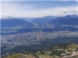 | Hungerberg (parking lot at the station of funicular) - Hafelekarspitze (from Hungerberg on path 216)
Hafelekarspitze is Innsbruck's home mountain and the most popular peak in one of the most admired ridges of the Eastern Alps: the Nordkette, whic...
4 h |
 | Losenheim (Parkplatz am Schneeberg) - Klosterwappen (Schneeberg) (via Schauerstein)
Schneeberg is the easternmost and, at the same time, the northernmost of the two-thousand peaks of the Alps, with its Kaiserstein (2061 m) and Kl...
4 h 15 min |
 | Losenheim (Parkplatz am Schneeberg) - Klosterwappen (Schneeberg) (mimo križa Witzanikreuz)
Schneeberg is the easternmost and, at the same time, the northernmost of the two-thousand peaks of the Alps, with its Kaiserstein (2061 m) and Kl...
4 h 35 min |
 | Oberort (parkirišče Zeleno jezero) - Messnerin (Kamplsteig)
...
3 h 30 min |
 | Seetal - Hochschwab
...
5 h |
| Seetal - Hochschwab (mimo koče Schiestelhaus)
...
5 h 5 min |
 | Losenheim (Parkplatz am Schneeberg) - Kaiserstein (Schneeberg) (via Schauerstein)
...
4 h 3 min |
 | Parkirišče Hoyer - Speikkogel (Gleinalpe)
...
3 h 15 min |
 | Parkirišče Hoyer - Lenzmoarkogel (Gleinalpe)
...
3 h 30 min |