Planina Pungrat - Veliko Kladivo
Starting point: Planina Pungrat (1447 m)
| Lat/Lon: | 46,4286°N 14,3572°E |
| |
Time of walking: 2 h 15 min
Difficulty: difficult marked way
Altitude difference: 647 m
Altitude difference po putu: 715 m
Map: Karavanke - osrednji del 1:50.000
Recommended equipment (summer):
Recommended equipment (winter): ice axe, crampons
Views: 21.877
 | 1 person likes this post |
Access to the starting point:
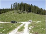
From the Ljubljana - Jesenice motorway, take the Ljubelj exit. Continue into the centre of Tržič and follow the road through Dolžanovo gorge to the village Jelendol, where the signs for mountain pasture Kofce, Šija and Pungrat direct you to the left. The road then loses its asphalt surface and starts to climb steeply. Follow this road at the junctions in the route mountain pasture Pungrat, near which you park in one of the roadside parking areas.
Path description:
From the parking lot, first walk to mountain pasture Pungrat, then a few tens of metres before the huts at mountain pasture turn left into a large meadow, over which you climb in a slight ascent to the edge of the forest, where you see a mountain sign for Škrbina (the initial part of the trail is poorly marked).
Continue the ascent along a moderately steep forest path rising above mountain pasture Pungrat. After about 20 minutes' walk from the starting point, you emerge from the forest onto steeper and steeper slopes, first with dwarf pines and then with only grass-covered slopes. After a good hour's walk, the steep path, with increasingly beautiful views, leads us to Škrbina, from which we have a view of the Austrian side.
From Škrbina, continue left in the direction of Veliki vrh (to the right of the Tegoška Gora). The way ahead first crosses a steep grassy slope and then passes onto a ridge, which is occasionally slightly exposed. The path continues mostly on the Slovenian side of the ridge, only occasionally crossing over to the northern Austrian side. Follow this scenic and sometimes very steep path, which is unguarded except for a short stretch, along a partially exposed ridge to the top of Kladiv, which is reached after about an hour's walk from Škrbina (high risk of slipping in the wet and snow).
Starting point - Škrbina 1:10, Škrbina - Kladivo 1:05.

Pictures:
 1
1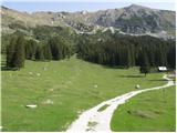 2
2 3
3 4
4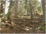 5
5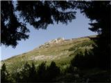 6
6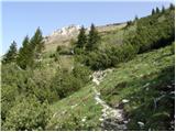 7
7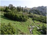 8
8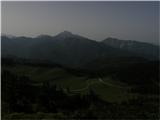 9
9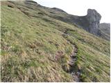 10
10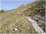 11
11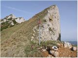 12
12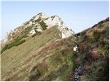 13
13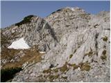 14
14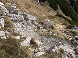 15
15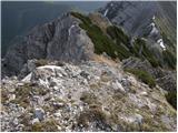 16
16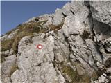 17
17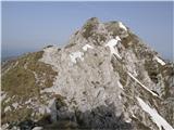 18
18 19
19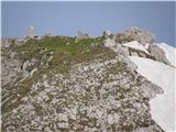 20
20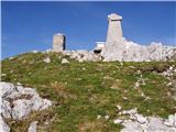 21
21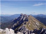 22
22
Discussion about the trail Planina Pungrat - Veliko Kladivo
|
| babim20. 08. 2017 |
Prosim za opis poti na Tegoško goro, nikjer je ne najdem. Zanima me izhodišče, opis poti in razmere na tej poti. Hvala za odgovor.
|
|
|
|
| babim23. 08. 2017 |
Danes sva z možem opravila turo Kofce-Šija-pl.Pungart-Škrbina-Pungartska gora. Cesta do Mrzlega studenca v precej slabšem stanju kot pred mesecem dni.Markirana pot iz pl. Pungart proti Škrbini do višine, kjer se pasejo krave, zelo razrita. Od Škrbine naprej do vrha pa je ves čas res potrebna opreznost.Vrnila sva se po isti poti in si na Kofcah zasluženo privoščila krasno gobovo juhico, da o sirovih štrukljih sploh ne govorim!
|
|
|
|
| mornar24. 07. 2021 18:05:24 |
Kakšno je stanje z cesto do planine Pungart.Šli bi z manjšim 20 sedežnim minibusom. Hvala in lep pozdrav.
|
|
|
|
| babim3. 09. 2021 10:02:43 |
Tudi mene zanima v kakšnem stanju je ta cesta
z navadnim osebnim avtomobilom? Hvala
|
|
|
|
| GITA3. 09. 2021 20:38:35 |
Kako bi šlo z minibusom težko ocenim. Bila do pl. Pungrat 20.8. z osebnim avtom (precej nizkim) in je šlo več ali manj brez težav, na dveh ali treh mestih je malo bolj za popazit.
Sta pa dva možna dostopa. V Jelendolu nas pod graščino smerokazi usmerijo levo za planine Šija, Kofce in Pungrat. Tam se je bolje držati desne in nadaljevati v smeri pl. Dolga njiva, potem pa na označenem križišču zaviti levo proti Pungratu. Tako informacijo sva dobila v Taborniškem domu Šija in očitno drži, kajti vsi ostali, ki so že v Jelendolu za Pungrat zavili levo, so se malo držali za glavo, ko so stopili iz avtomobilov... Pa lepo turo želim!
|
|
|
|
| Klinar2719. 08. 2023 10:22:03 |
Ali kdo ve ali je cesta do planine Pungrat ali do planine Šija prevozna od zadnjih povodenj?
|
|
|
|
| Spelcarocket21. 08. 2023 06:54:26 |
Nismo se peljali direkt do Šije pač pa do kapelice. Do tam prevozna je, sicer precej razrita a s terencem gre. Na Pungartu parkiranih nekaj avtov. Srečno
|
|
|