 | Ljubelj - Loibler Baba/Košutica (via koča na Ljubelju)
Loibler Baba (also Ljubeljska Baba) is a scenic mountain located north of the western ridge of Košuta. From the top, where there is a small cross...
2 h 45 min |
 | Bučan - Loibler Baba/Košutica
Loibler Baba (also Ljubeljska Baba) is a scenic mountain located north of the western ridge of Košuta. From the top, where there is a small cross...
2 h 45 min |
 | The Krma Valley - Mrežce
Mrežce is a prominent peak near Lipanski vrh which can be seen on the other side of the ravine between the two peaks. As the slopes towards Poklj...
2 h 50 min |
 | The Krma Valley - Lipanski vrh
The summit is located above Blejska koča on the mountain pasture of Lipanca. From the summit, which descends precipitously towards the Krma valle...
2 h 45 min |
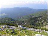
 | The Krma Valley - Debela peč
Debela peč is a 2014 m high mountain that rises steeply above the Krma valley on one side and descends gently towards the vast Pokljuka forests o...
3 h 15 min |
 | Dom pod Storžičem - Storžič (via Škarjev rob)
Storžič is a 2132 m high mountain located in the western part of the Kamink Savinja Alps. From the top with a cross there are beautiful views of ...
3 h |
 | Jekarica - Storžič
Storžič is a 2132 m high mountain located in the western part of the Kamink Savinja Alps. From the top with a cross there are beautiful views of ...
3 h |
 | Iličev rovt / Illitsch Rauth - Mittagskogel/Kepa (path 680)
Kepa, also Jepa, or Mittagskogel in German, is a scenic mountain in the western Karawanks, located on the border ridge between Slovenia and Austr...
3 h |
 | V Koncu - Kalška gora
Kalška gora is located between Kalški greben and Kokrsko sedlo. From the top, which is covered with grass, there is a beautiful view towards the ...
3 h 15 min |
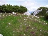
 | The Krma Valley - Brda
Brda is a scenic peak located between Pokljuka and Krma. From the top, where a stamp is attached to a metal pole, we have a beautiful view toward...
2 h 45 min |
 | Ravenska Kočna - Vratca (past the cableway)
The summit is located west of the Bohemian Cottage. It can be identified by the shape of the tower. There is little space at the very top. But it...
2 h 15 min |
| Ravenska Kočna - Vratca (umik Žrela)
The summit is located west of the Bohemian Cottage. It can be identified by the shape of the tower. There is little space at the very top. But it...
2 h 20 min |
| Ravenska Kočna - Vratca (via Štularjeva planina)
The summit is located west of the Bohemian Cottage. It can be identified by the shape of the tower. There is little space at the very top. But it...
2 h 15 min |
| Makekova Kočna - Vratca
The summit is located west of the Bohemian Cottage. It can be identified by the shape of the tower. There is little space at the very top. But it...
2 h 45 min |
 | Dom na Gospincu - Vrh Korena (via Zvoh)
Vrh Korena is located between Zvoh and Kalški greben near the Krvavški ski slopes. From the top there is a beautiful view towards the highest pea...
2 h 40 min |
| Planina Jezerca - Vrh Korena (via Dom na Krvavcu)
Vrh Korena is located between Zvoh and Kalški greben near the Krvavški ski slopes. From the top there is a beautiful view towards the highest pea...
2 h 55 min |
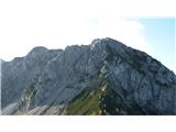
 | Planina Pungrat - Veliko Kladivo
Veliko Kladivo is a 2094 m high peak in the Košuta Ridge, the longest Slovenian ridge. From the summit, which has a registration box and a stamp,...
2 h 15 min |
 | Bodenbauer - Ovčji vrh (Kozjak) / Geissberg (Kosiak) (direct way)
Ovčji vrh or Kozjak, or Geissberg or Kosiak in German, is a 2024 m high peak located north of the main ridge of the Karavanke Mountains. The peak...
3 h |
| Bodenbauer - Ovčji vrh (Kozjak) / Geissberg (Kosiak) (via Klagenfurter Hütte)
Ovčji vrh or Kozjak, or Geissberg or Kosiak in German, is a 2024 m high peak located north of the main ridge of the Karavanke Mountains. The peak...
3 h 15 min |
 | Bodenbauer - Bielschitza/Svačica
Bielschitza is a less prominent peak in the main ridge of the Karavanke. It is located between Vertatscha and Stol and is slightly offset to the ...
3 h 15 min |
 | Tolminske Ravne - Vogel (steep path)
When you hear the name Vogel, many people first think of the Vogel ski resort, which is located near the peak of the same name. From the north si...
3 h |
 | Podolševa (Rogar) - Govca (Olševa) (direct way)
Govca is the highest peak of the Olševa, a mountain range rising above Koprivna, Solčava and Remschenik (Remschenik / Remschenig is a valley on t...
2 h 10 min |
 | Podolševa (Sveti Duh, Strevc) - Govca (Olševa) (via Obel kamen)
Govca is the highest peak of the Olševa, a mountain range rising above Koprivna, Solčava and Remschenik (Remschenik / Remschenig is a valley on t...
2 h 30 min |
| Podolševa (Sveti Duh, Strevc) - Govca (Olševa)
Govca is the highest peak of the Olševa, a mountain range rising above Koprivna, Solčava and Remschenik (Remschenik / Remschenig is a valley on t...
2 h 15 min |
| Podolševa (Rogar) - Govca (Olševa) (via Obel kamen)
Govca is the highest peak of the Olševa, a mountain range rising above Koprivna, Solčava and Remschenik (Remschenik / Remschenig is a valley on t...
2 h 25 min |
 | Jochalm - Reißkofel (235-1)
Reißkofel is a 2371 metre high mountain in the Zilj Alps. The summit on which the cross stands also has a registration box. The view from the top...
3 h |
 | Belopeška jezera - Mala Ponca / Ponza Piccola
Mala Ponca is a 1925m high peak located between Planica and the Belopeci lakes. Although the peak is lower than the neighbouring Visoka Ponca, it...
2 h 45 min |
 | Dom v Tamarju - Srednja Ponca / Ponza di Mezze
Srednja Ponca is a 2228m high peak rising steeply above Tamar, Planica and the Mangart valley. From the summit on which the stamp is located, the...
3 h 15 min |
 | Plockenpass - Monte Floriz
Monte Floriz is a 2184m high grassy peak located south of the Marinelli hut. From the summit there is a very fine view of the Coglians group, and...
3 h |
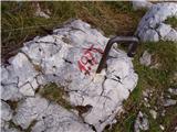
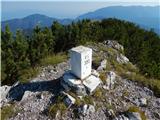
 | The Krma Valley - Okroglež
Okroglež is a dwarf pines vegetated peak located between Debela peč and Brdy. From the summit, which has a stamp (without a registration book), w...
2 h 55 min |
 | Sella Nevea - Monte Bila pec
White oven, or Italian. Monte Bila pec is a 2146 m high mountain located to the north of the main Kanin ridge. From the top, where there is a reg...
2 h 45 min |
 | Ljubelj - Lokovnikov Grintovec / Grintoutz (via Koča na Ljubelju)
Lokovnikov Grintovec is the dwarf pines vegetated peak to the north of Loibler Baba, from which it is separated by Dovjakovo sedlo (1728 m). Its ...
2 h 45 min |
 | Bučan - Lokovnikov Grintovec / Grintoutz
Lokovnikov Grintovec is the dwarf pines vegetated peak to the north of Loibler Baba, from which it is separated by Dovjakovo sedlo (1728 m). Its ...
2 h 45 min |
 | Podolševa (Sveti Duh, Strevc) - Obel kamen (Olševa) (west path)
Obel kamen is a 1911 m high peak located in the Olševa Ridge. On the summit there is a boundary stone marked RS XXII 1, the cross and the registr...
2 h |
| Podolševa (Rogar) - Obel kamen (Olševa) (west path)
Obel kamen is a 1911 m high peak located in the Olševa Ridge. On the summit there is a boundary stone marked RS XXII 1, the cross and the registr...
1 h 55 min |
 | Podolševa (Sveti Duh, Strevc) - Obel kamen (Olševa) (east path)
Obel kamen is a 1911 m high peak located in the Olševa Ridge. On the summit there is a boundary stone marked RS XXII 1, the cross and the registr...
2 h 15 min |
| Podolševa (Rogar) - Obel kamen (Olševa) (east path)
Obel kamen is a 1911 m high peak located in the Olševa Ridge. On the summit there is a boundary stone marked RS XXII 1, the cross and the registr...
2 h 10 min |