Starting point: Koča pri Savici (653 m)
| Lat/Lon: | 46,2896°N 13,8022°E |
| |
Time of walking: 7 h
Difficulty: easy pathless terrain
Altitude difference: 1575 m
Altitude difference po putu: 1730 m
Map: Triglav 1:25.000
Recommended equipment (summer): helmet
Recommended equipment (winter): helmet, ice axe, crampons
Views: 10.290
 | 6 people like this post |
Access to the starting point:
From the Ljubljana - Jesenice motorway, take the Lesce exit and follow the road towards Bled and on to Bohinjska Bistrica. Continue driving towards Bohinjsko jezero (Ribčev laz), at which you will come to a crossroads, where you will continue straight along the left (south) side of the lake in the direction of Ukanec and the Savica waterfall. Follow this increasingly narrow road to the large parking lot at the Savica cottage. There is a charge for parking.
Path description:
From the parking lot, follow the road that crosses the Savica River via a bridge. Continue along the path in the direction of the Triglav Lakes. The initially gentle path soon becomes steep and climbs up the southern lower slopes of Komarča. After a good half an hour's walk, the path becomes even steeper and leads to technically difficult places. The path along the Komarča wall is beautifully laid out, but care is needed at every step to avoid slipping. In the more difficult places, the fixed safety gear are helpful to get to the top of the wall more safely. The steep climb, which takes about an hour, ends with a view down the valley to the parking lot where the car is parked. The steepness then eases, and the path leads us to the Black Lake in five minutes of easy walking.
At the beginning of the lake, the path to the right branches off at mountain pasture Viševnik and Pršivec, and we continue straight on along the right-hand side of the lake. On the other side of the lake, the path leads to the next crossroads. Continue straight on towards the huts at Triglav Lakes (Komna on the left). The path continues to climb under the walls of Stador on the right and the Lopučnica forest on the left. After a while the path leads to a grassy clearing where the marked path turns right steeply upwards. After 15 minutes the steepness eases and after a further 15 minutes the path leads to the next crossroads, where it continues to the left (to the right mountain pasture Ovčarija, Dedno polje and Blato). There is a gentle climb up to a point where you can see the Double Lake in front of you. The trail continues gently downhill to the lake and continues on the right-hand side. Here you come to a crossroads where the path to Tičarica branches off to the right. Continue on the lower path, which after a few minutes of further walking leads us to the hut at Triglav Lakes, which we can see in front of us.
From the hut, continue sharp left in the direction Dom na Komni along the path which begins to climb crosswise along the western side of the Double Lake. After a short climb, you reach an indistinct ridge, from which the path turns right and begins to descend. After a half-hour's descent, the path leads to the mountain pasture Hatch, where there is a crossroads. Continue right in the direction mountain pasture Behind the rock (slightly to the left, the Komna House) on a less well-trodden path which crosses the slopes of mountain pasture to the north-west. The path, which passes through tall grasses (in summer), crosses a little higher up the lane of sparse wodland and then turns slightly to the left. The path then climbs steeply and, within a few minutes of further walking, leads to a karst world of potholes and scrapes. Here the path lays down and starts to disappear into the rocky world (follow the markings carefully). At this point, we have a wonderful view of the mountains surrounding the Triglav Lakes Valley. The marked trail is then followed only as far as the Velika vrata prevala, which is reached after a few more minutes of gentle ascent.
On the other side of the Velika vrata, leave the already little-visited path and continue right along the pathless world. At first, the transitions between dwarf pines and the scrambly world are relatively easy, as "the way" is helped by finding cairns, which are admittedly rare. The ascent continues in a somewhat northerly direction, but there are no direct passages due to the karst world. Because of the crevasses, we have to make quite a big detour from time to time. When the "path" just leads us to the ridge, the orientation lops are over. We continue our ascent along the increasingly scenic ridge, and the "path" then quickly leads us to the inexpressible summit of Glave za Bajto.
Next, we descend slightly, then climb the grassy slope of Čela to a little-known and even less-visited peak.
Starting point - Hut at Triglav Lakes 3:00, Hut at Triglav Lakes - Velika vrata 2:30, Velika vrata - Čelo 1:30.

Pictures:
 1
1 2
2 3
3 4
4 5
5 6
6 7
7 8
8 9
9 10
10 11
11 12
12 13
13 14
14 15
15 16
16 17
17 18
18 19
19 20
20 21
21 22
22 23
23 24
24 25
25 26
26 27
27 28
28 29
29 30
30 31
31 32
32 33
33 34
34 35
35 36
36 37
37 38
38 39
39 40
40 41
41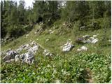 42
42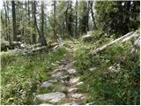 43
43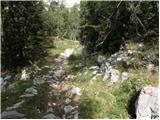 44
44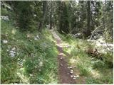 45
45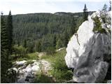 46
46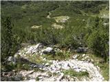 47
47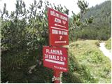 48
48 49
49 50
50 51
51 52
52 53
53 54
54 55
55 56
56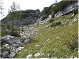 57
57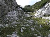 58
58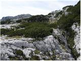 59
59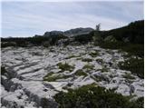 60
60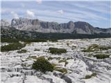 61
61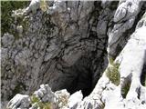 62
62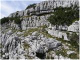 63
63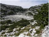 64
64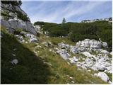 65
65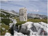 66
66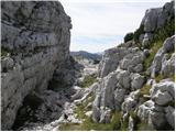 67
67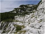 68
68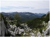 69
69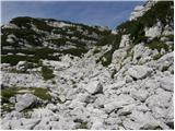 70
70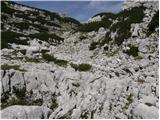 71
71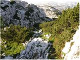 72
72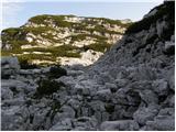 73
73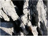 74
74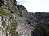 75
75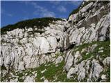 76
76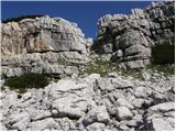 77
77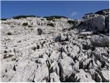 78
78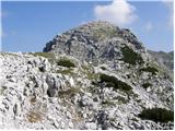 79
79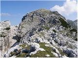 80
80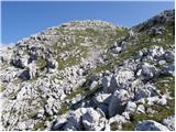 81
81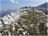 82
82
Discussion about the trail Koča pri Savici - Čelo
|
| Guest5. 07. 2006 |
a se tuki da poleti tudi osvežiti v jezeru
|
|
|
|
| Mojster geodet14. 07. 2006 |
hehe, če želiš staknit plučnico ni problema, za osvežitev bl priporočam krnsko jezero pa še lepa pot je(po sledeh zgodovine)
|
|
|