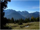
 | Planina Jezerca - Veliki Zvoh (on unmarked path via Razor)
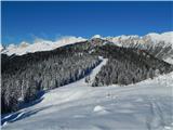
Veliki Zvoh is the highest point of the Krvavec ski resort. The cable car does not quite reach the top, but it is only a few metres short of the ...
2 h 15 min |
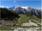
 | End of road on Pokljuka - Viševnik (via Gola Ravan)
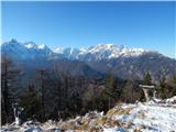
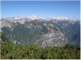
Viševnik is a 2050 m high mountain rising north-west of Rudno polje on Pokljuka. From the top of the peak where the stamp is located, you have a ...
2 h 15 min |
| Rudno polje - Viševnik (via Gola Ravan)
Viševnik is a 2050 m high mountain rising north-west of Rudno polje on Pokljuka. From the top of the peak where the stamp is located, you have a ...
2 h 15 min |
 | End of road on Pokljuka - Viševnik (via source of Zlata voda)
Viševnik is a 2050 m high mountain rising north-west of Rudno polje on Pokljuka. From the top of the peak where the stamp is located, you have a ...
2 h 20 min |
| Rudno polje - Viševnik (via source of Zlata voda)
Viševnik is a 2050 m high mountain rising north-west of Rudno polje on Pokljuka. From the top of the peak where the stamp is located, you have a ...
2 h 20 min |
| Uskovnica (Razpotje) - Viševnik (via source of Zlata voda)
Viševnik is a 2050 m high mountain rising north-west of Rudno polje on Pokljuka. From the top of the peak where the stamp is located, you have a ...
2 h 55 min |
| Uskovnica (Razpotje) - Viševnik (via Gola Ravan)
Viševnik is a 2050 m high mountain rising north-west of Rudno polje on Pokljuka. From the top of the peak where the stamp is located, you have a ...
2 h 50 min |
 | Rudno polje - Mrežce (via Zgornji Razor)
Mrežce is a prominent peak near Lipanski vrh which can be seen on the other side of the ravine between the two peaks. As the slopes towards Poklj...
2 h |
 | Gozd - Tolsti vrh (Ovčja pot over Kriška gora)
Tolsti vrh, located to the west of Storžič, is also the highest peak of the Kriška Gora, a mountain range rising steeply above the central Gorenj...
2 h 30 min |
 | Tržiški graben - Veliki Javornik (Ženiklovec)
Veliki Javornik or Ženiklovec is a 1716 m high peak located between Storžič and Stegovnik. From the grassy summit, where the registration box is ...
2 h 30 min |
 | Križovec - Barentaler Kotschna/Struška (footpath)
Barentaler Kotschna is a small mountain range located between Stolo or Belščica and Golica. From Veliki vrh, as the highest peak of the mountain ...
2 h 30 min |
| Križovec - Barentaler Kotschna/Struška (by road)
Barentaler Kotschna is a small mountain range located between Stolo or Belščica and Golica. From Veliki vrh, as the highest peak of the mountain ...
2 h 15 min |
 | Planina pod Golico - Kahlkogel/Golica (via Ovčarska koča - eastern way)
Kahlkogel is an unvegetated peak located north of Jesenice. From the top, which has a registration box, there is a beautiful view of the western ...
2 h 45 min |
 | Križovec - Kahlkogel/Golica (on ridge)
Kahlkogel is an unvegetated peak located north of Jesenice. From the top, which has a registration box, there is a beautiful view of the western ...
2 h |
| Dom Pristava in Javorniški Rovt - Kahlkogel/Golica (on ridge)
Kahlkogel is an unvegetated peak located north of Jesenice. From the top, which has a registration box, there is a beautiful view of the western ...
2 h 45 min |
 | Erjavčev rovt - Frauenkogel/Dovška Baba (direct way)
Frauenkogel is an 1891 m high peak located on the border ridge between Slovenia and Austria. The summit, which has a registration box and a stamp...
2 h 15 min |
 | Rogarjev rovt - Frauenkogel/Dovška Baba (via Rožca and Hruški vrh)
Frauenkogel is an 1891 m high peak located on the border ridge between Slovenia and Austria. The summit, which has a registration box and a stamp...
2 h 30 min |
 | Tinčkova koča - Srednji vrh (above Završnica) (via Zagon)
Srednji vrh is a scenic and dwarf pines mountain located between Stol, Vertatscha and Begunjščica. From the summit, which descends precipitously ...
2 h |
 | Smrečje - Pečovnik (survey point 1668) (by road)
Pečovnik) is a 1668 m high mountain located between Plešivec (1801 m) and Virnik's Grintovec (1654 m). The grassy peak, located on the border bet...
2 h 45 min |
 | Jezerski vrh - Pečovnik (survey point 1668)
Pečovnik) is a 1668 m high mountain located between Plešivec (1801 m) and Virnik's Grintovec (1654 m). The grassy peak, located on the border bet...
2 h 45 min |
 | Jezerski vrh - Plešivec
Plešivec is an 1801 m high peak located south of the eastern part of Košuta. The summit, on which the border signpost stands, offers a beautiful ...
3 h 30 min |
 | Rateče - Ofen/Peč (western path, past bivouac and on footpath)
Peč (also Tromeja), in Italian Monte Forno and in German Dreiländereck or Ofen, is a 1508 m high peak located on the tri-border between Slovenia,...
2 h 15 min |
| Rateče - Ofen/Peč (western path, past bivouac and on mule track)
Peč (also Tromeja), in Italian Monte Forno and in German Dreiländereck or Ofen, is a 1508 m high peak located on the tri-border between Slovenia,...
2 h 20 min |
 | Polja - Ofen/Peč (via Petelinjek)
Peč (also Tromeja), in Italian Monte Forno and in German Dreiländereck or Ofen, is a 1508 m high peak located on the tri-border between Slovenia,...
2 h 45 min |
| Polja - Ofen/Peč (via Kališje)
Peč (also Tromeja), in Italian Monte Forno and in German Dreiländereck or Ofen, is a 1508 m high peak located on the tri-border between Slovenia,...
2 h 15 min |
 | Rudno polje - Debeli vrh above Lipanca (via Zgornji Razor)
Debeli vrh is a 1962 m high mountain located in a ridge of mountains rising steeply above the Krma valley. From the top, where a stamp is attache...
2 h 15 min |
 | Ravne - Rosenkogel/Hruški vrh (via Dovška Baba)
Rosenkogel is a 1776 m high mountain located between Frauenkogel and the slightly less known Klek. From the top, where there is a small chapel de...
2 h 25 min |
 | Ravne - Klek (via Hruški vrh)
Klek is a 1753 m high mountain located between Rosenkogel and the more famous Golica. The summit, which borders between Slovenia and Austria, off...
2 h 30 min |
| Planina pod Golico - Klek (via Rožca)
Klek is a 1753 m high mountain located between Rosenkogel and the more famous Golica. The summit, which borders between Slovenia and Austria, off...
2 h 20 min |
 | Planina pod Golico - Klek (via Ovčarska koča)
Klek is a 1753 m high mountain located between Rosenkogel and the more famous Golica. The summit, which borders between Slovenia and Austria, off...
3 h |
 | Srednji vrh - Vošca
Vošca is a 1737 m high peak located west of Trupe's Non. From the grassy summit, we have a beautiful view of Julian Alps, the western Karawanks, ...
2 h |
 | Srednji Vrh - Vošca (via Zajčnik)
Vošca is a 1737 m high peak located west of Trupe's Non. From the grassy summit, we have a beautiful view of Julian Alps, the western Karawanks, ...
2 h 35 min |
| Srednji Vrh - Vošca (via Jureževa planina)
Vošca is a 1737 m high peak located west of Trupe's Non. From the grassy summit, we have a beautiful view of Julian Alps, the western Karawanks, ...
2 h 5 min |
 | Srnjak - Vošca
Vošca is a 1737 m high peak located west of Trupe's Non. From the grassy summit, we have a beautiful view of Julian Alps, the western Karawanks, ...
2 h 45 min |
 | Gate (Belca) - Kresišče (by road)
Kresišče is a 1839 m high peak located in the main ridge of Karawanks, more precisely between Kepa and Trupe's Non. From the summit, on which sta...
3 h |
 | Srednji Vrh - Kresišče (via Grajšca)
Kresišče is a 1839 m high peak located in the main ridge of Karawanks, more precisely between Kepa and Trupe's Non. From the summit, on which sta...
2 h 50 min |
177100.th.jpg) | Gate (Belca) - Mojstrovica
Mojstrovica is a scenic grassy peak located in the western part of Karawanks, more precisely between the valley of the Belka River and the valley...
2 h 20 min |
438900.th.jpg) | Gate (Belca) - Visoki vrh (by road)
Visoki vrh (also Visoki Kurji vrh) is a 1828 m high mountain located west of the Belka River valley. From the summit, on which stands a small cai...
2 h 55 min |
 | Gate (Belca) - Visoki vrh (via Bašinov breg)
Visoki vrh (also Visoki Kurji vrh) is a 1828 m high mountain located west of the Belka River valley. From the summit, on which stands a small cai...
2 h 40 min |
 | Urbas - Weinasch/Vajnež
Weinasch is the highest peak of Belščice, a mountain range located to the west of the better known Stoľa. From the top, where the cross and the S...
2 h 25 min |
| Olipova planina - Weinasch/Vajnež (via Hrašenska planina)
Weinasch is the highest peak of Belščice, a mountain range located to the west of the better known Stoľa. From the top, where the cross and the S...
2 h 50 min |
 | Ravne - Jerebikovec
The peak is slightly overgrown and is situated above Mojstrana and Radovna. From the top there is a beautiful view towards Karawanks and the moun...
2 h 45 min |
| Planina Spodnji Kozjek - Jerebikovec
The peak is slightly overgrown and is situated above Mojstrana and Radovna. From the top there is a beautiful view towards Karawanks and the moun...
2 h 30 min |
 | Javorje - Šija (via Kratki plaz)
The peak is located above the Vogel ski slope in the Lower Bohinj Mountains. From the top there is a beautiful view of the neighbouring peaks in ...
2 h 40 min |
 | Urbas - Potoški Stol
Potoški Stol is located between Hochstuhl and Weinasch on the border with Austria. Just a few metres below the grassy peak, a cross is erected. T...
2 h 15 min |
| Olipova planina - Potoški Stol
Potoški Stol is located between Hochstuhl and Weinasch on the border with Austria. Just a few metres below the grassy peak, a cross is erected. T...
2 h 40 min |
 | Dom na Smrekovcu - Komen (via Smrekovec and Krnes)
At 1684m, Komen is the highest peak of the Smrekov Mountains, a mountain range bordering Styria and Carinthia. From the top, in good weather, we ...
2 h 20 min |
 | Dolina potoka Žep - Komen
At 1684m, Komen is the highest peak of the Smrekov Mountains, a mountain range bordering Styria and Carinthia. From the top, in good weather, we ...
2 h 30 min |
 | Dolina potoka Žep - Veliki Travnik (via partisan hospital)
Veliki Travnik, or Turnovka as the locals call it, is located on the western edge of the Smrekov Mountains. From the top of the hill, where a woo...
2 h 25 min |
 | Mislinjski graben (Pestotnik) - Rogla (via Ostruščica)
Rogla is the peak in the middle of the ski resort of the same name. The summit is woded with a small clearing on which stands a lookout tower. Th...
3 h |
 | Smrečje - Pečovnik (by road)
Pečovnik is a 1640 m high peak located in the mountain ridge between Košuta and Virnik Grintovec. The partially vegetated peak offers a beautiful...
2 h 35 min |
 | Jezerski vrh - Pečovnik
Pečovnik is a 1640 m high peak located in the mountain ridge between Košuta and Virnik Grintovec. The partially vegetated peak offers a beautiful...
2 h 35 min |
 | Jevšček - Monte Mataiur/Matajur
Monte Mataiur is a scenic mountain located on the border between Slovenia and Itali. From the top, you have a beautiful view of the Kobarid or Br...
2 h 30 min |
 | NC Planica - Glave (by ski jumping hill)
Glave are an undistinguished side ridge of the Ponce, rising steeply to the west of Planica. The highest peak of Glav, which measures 1760m, is c...
2 h 30 min |
| Rateče (Ledine) - Glave
Glave are an undistinguished side ridge of the Ponce, rising steeply to the west of Planica. The highest peak of Glav, which measures 1760m, is c...
2 h 50 min |
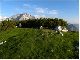
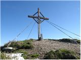
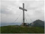
 | Planina Jezerca - Krvavec (on unmarked path via Razor)
Krvavec is an 1853 m high peak located in the heart of the ski resort of the same name. The summit, which is criss-crossed with cable cars, offer...
2 h |
| Markova raven - Krvavec (on unmarked path via Razor)
Krvavec is an 1853 m high peak located in the heart of the ski resort of the same name. The summit, which is criss-crossed with cable cars, offer...
2 h 45 min |
 | Rutarski gozd - Jehlc (Špičasta kupa)
For Jehlc we will get different names on different maps, which also differ in height. The locals call the peak Jehlc (1625 m), but on more recent...
2 h |
 | Korensko sedlo - Kamnati vrh/Steinberg (via Jerebikovec)
Kamnati vrh is a 1621 m high mountain located north of Kranjska Gora. The grassy summit, on which the bench is located, is not visible due to the...
2 h |
 | Ravne - Kleiner Frauenkogel/Koprivnjak
Kleiner Frauenkogel (Little Frauenkogel) is a 1754 m high peak located on the Austrian side of the Karavanke Mountains. From the top, where the c...
2 h 20 min |
 | 2nd hairpin turn of Vršič road - Visoki Mavrinc (Za Kumlehom)
Visoki Mavrinc (Špica v Sedelcih) is a 1562 m high mountain located between Suha, Mala and Velika Pišnica. From the top of the peak, where there ...
2 h |
 | Koprivna (Kumer) - Velika glava (via Knipsovo sedlo)
Velika glava is a peak in the Peć mountain range, located between Petzen and Končnik's Peak. The summit, which borders Austria, offers a beautifu...
3 h 10 min |
 | Mangartska planina - Šober / Monte Sciober Grande (via Dren)
Šober is a 1845 m high peak located between Remšendol and the Jezersko Valley. From the top you can enjoy a beautiful view of the nearby Rabeljsk...
2 h 35 min |
 | Spodnje Danje - Altemaver (Ratitovec)
Altemaver is the highest peak of Ratitovec at 1678 m. The grassy peak offers a beautiful view of Julian Alps, Jelovica, Karawanks, Kamnik Savinja...
2 h 30 min |
 | Srednji Vrh - Maloško poldne / Mallestiger Mittagskogel
Maloško poldne or Mallestiger Mittagskogel in German is a 1823 m high peak located on the border between Slovenia and Austria, more precisely bet...
2 h 55 min |
 | Dom Pristava in Javorniški Rovt - Mala Golica
Mala Golica is a less distinct peak located east of Krvavka. From the grassy peak, we have a beautiful view of the Drava Valley, Barentaler Kotsc...
2 h 15 min |
 | Vas na Skali - Čisti vrh
Čisti vrh is a 1875 m high mountain located north of the Špičje ridge, more precisely on the lookout above the Čez Drt saddle. From the summit, w...
3 h 30 min |
 | Planina Blato - Krsteniški Stog (hunting path)
Krsteniški or Little Stog is a 1879 m high mountain rising steeply above mountain pasture Krstenica. From the top, on which stands a stone cairn,...
2 h 15 min |
 | Srednji Vrh - Zajčnik
Zajčnik (also Blekova) is a 1746 m high peak located northeast of Voška. The partially vegetated peak, which borders between Slovenia and Austria...
2 h 10 min |
 | Vrh Bače - Rušni vrh
Rušni vrh is a 1786 m high peak located to the east of Črna prsti. From the summit, which is the boundary stone of the old Rapallo border, we hav...
3 h |
 | Spodnje Danje - Kremant (Ratitovec)
Kremant is a 1654 m high peak located in the western part of Ratitovec. From the top, where a stamp is attached to a metal pole, we have a beauti...
2 h 30 min |
 | Kosmačev preval - Lengarjeva glava
Lengarjeva glava is a 1498 m high peak located between the valleys of Vrata and Kot. From the partially vegetated summit, we have a beautiful vie...
3 h 30 min |
 | Srnjak - Grpišca
Grpišca is a 1676 m high grassy peak located in the main ridge of Karawanks, more precisely between Kamnati vrh and Vošca. The summit, which bord...
2 h |
 | Srnjak - Tamarča
Tamarča is a lesser known peak located northwest of Voška. The summit, surrounded by a larch forest, offers a beautiful view of the Martuljka gro...
2 h 30 min |
 | Carbonin - Knollkopf / Col Rotondo dei Canope
The 2204-metre-high mountain is located in the Fanes Sennes Prags Nature Park. The mountain is mostly covered with dwarf pines and has a cross at...
3 h |
 | Rateče - Monte Coppa
Kopa (also Kopje on some maps) or after ital. Monte Coppa is a 1496 metres high peak located on the Italian side of the Karavanke Mountains. The ...
2 h |
 | Sele pri Cerkvi / Zell - Pfarre - Mejnik
Mejnik is a 1517 m high peak located on the Austrian side of Karawanks, more precisely in the side ridge of Kosuta. There is a milestone on the s...
1 h 55 min |
| Ridovc / Ridovcsäge - Mejnik (via valley of Mrzli potok)
Mejnik is a 1517 m high peak located on the Austrian side of Karawanks, more precisely in the side ridge of Kosuta. There is a milestone on the s...
2 h 5 min |
 | Javorje - Hunting cottage Na Glinu
Hunting cottage Na Glinu is located on a lookout between the mountains Suha and Poljana. The hut offers a beautiful view of Triglav and most of t...
2 h |
| Vodel - Hunting cottage Na Glinu
Hunting cottage Na Glinu is located on a lookout between the mountains Suha and Poljana. The hut offers a beautiful view of Triglav and most of t...
2 h 35 min |
 | Podkoren - Visoka Bavha
Visoka Bavha is a 1650 m high peak located in the Karavanke border ridge. The view of the Austrian side is better from the summit, as the view of...
2 h |
 | Vodel - Gradovec
Gradovec is a 1692 m high peak located north of the ridge of the Lower Bohinj Mountains, above mountain pasture Poljana. From the summit, where d...
1 h 55 min |
| Javorje - Gradovec (path over Glin)
Gradovec is a 1692 m high peak located north of the ridge of the Lower Bohinj Mountains, above mountain pasture Poljana. From the summit, where d...
3 h 10 min |
 | Polja - Petelinjek (above Korensko sedlo) (via Kališje)
Petelinjek is a small ridge located west to south-west of Korenski sedlo. The ridge is mostly on the Slovenian side, with only the highest peak b...
2 h |
 | Mislinjski graben (Pestotnik) - Ostruščica
Ostruščica is a 1498 m high peak located west of the ski slopes at Rogla....
2 h 30 min |
 | Trbiž / Tarviso - Florjanka / Monte Florianca (on transport road)
Florjanka is a 1,653-metre-high mountain on the Italian side of the Julian Alps. At the top or just below it, there is a reservoir for snowmaking...
2 h 30 min |
 | Concentration camp - Hajnžev Praprotnik / Zeller Prapotnik
Hajnžev Praprotnik is a 1727 m high peak located on the Austrian side of Karawanks, more precisely between Loibler Baba and the village of Sele-Z...
3 h 15 min |
| Vranček - Hajnžev Praprotnik / Zeller Prapotnik
Hajnžev Praprotnik is a 1727 m high peak located on the Austrian side of Karawanks, more precisely between Loibler Baba and the village of Sele-Z...
3 h 20 min |
 | Slovenji Plajberk / Windisch Bleiberg - Kosmatica / Kosmatitza
Kosmatica is a 1659 m high peak located entirely on the Austrian side of Karawanks, north of Vrtača. The summit, which is partly covered by fores...
3 h |