end of road on Pokljuka - Veliki Draški vrh
Starting point: end of road on Pokljuka (1340 m)
| Lat/Lon: | 46,3386°N 13,9045°E |
| |
Time of walking: 3 h
Difficulty: partly demanding unmarked way
Altitude difference: 903 m
Altitude difference po putu: 903 m
Map: Triglav 1:25.000
Recommended equipment (summer):
Recommended equipment (winter): ice axe, crampons
Views: 60.220
 | 6 people like this post |
Access to the starting point:
a) Leave the Gorenjska motorway at the exit for Lesce, then follow the signs for Bled and Pokljuka. Continue through Gorje and past the Zatrnik ski resort to Rudni Polje on Pokljuka, where there is a large pay parking lot, and a military barracks and shooting range nearby. From here, continue straight along the macadam road, which leads us a little further to a crossroads, where we continue to the right (Uskovnica on the left). Follow this road to the former parking lot Za Ribnico, which is at the end of the road (there are mountain signs for mountain pasture Konjščico).
After the new parking at the end of the road is forbidden, so we park already at Rudne polje, which lengthens the route by about 40 minutes, but it is more convenient to choose the marked trail, which starts already at Rudne polje.
b) From Železniki or Podbrdo, take the road to Bohinjska Bistrica and then continue in the direction of Bled. Shortly after the Petrol station, which is located just after Bohinjska Bistrica, turn left in the direction of Pokljuka and Jereka. The road climbs steeply at first, then gradually flattens out behind Koriti, leading to a junction by the bus station, where you continue right in the direction of Pokljuka, Koprivnik and Jereka (straight ahead Srednja vas). Just after the crossroads we arrive at Jereka, and from the crossroads in front of the church we continue straight on towards Pokljuka (left Podjelje). After Jereka the road starts to climb steeply again, and higher up it levels off and continues along the Mrzle potok. When you join the road from Bled, go left and drive to Rudno Polje, where there is a large pay parking lot, and also a military barracks and shooting range nearby. From here, continue straight along the macadam road, which leads us a little further to a crossroads, where we continue to the right (Uskovnica on the left). Follow this road to the former parking lot Za Ribnico, which is at the end of the road (there are mountain signs for mountain pasture Konjščico).
After the new parking at the end of the road is forbidden, so we park already at Rudne polje, which lengthens the route by about 40 minutes, but it is more convenient to choose the marked trail, which starts already at Rudne polje.
Path description:
From the former parking lot at the end of the road, follow the wide and initially ascending cart track towards mountain pasture of Konjščice. The cart track, which goes immediately into the dense forest, is quickly laid and after a few minutes of easy walking turns into a footpath which continues along the left bank of the Ribnica stream. When the path is close to the stream, it turns slightly to the right and climbs steeply. Higher up, the path lays down and leads out of the forest to the lower edge of the vast Konjščice River. Here the path turns slightly to the left, crosses a small stream and, after a few further steps, leads us to the cheese cottage at mountain pasture Konjščica.
From the cheese cottage, continue along a pleasant path which, after a few minutes of gentle ascent, leads to the upper edge of mountain pasture. Here the path goes into lane of dwarf pines and scrub and gradually starts to climb more steeply. In the upper part of the ascent towards Jezerce, the path from Rudno Polje joins us from the right, and we continue straight on the moderately steep path, which leads us within a few minutes of further walking to Jezerce, where the path is laid and turns to the left.
An easy walk follows to a sign marking the central area of the TNP, and then the path begins to climb moderately along the torrent (initially a small spring). The path goes higher up to the right side of the torrent (as seen from the route of the climb) and then crosses to Studorski preval, which opens up to a beautiful view of the Bohinj side of Bohinj.
From Studorski preval continue right (left Ablanca, straight Vodnikov dom, sharp right Srenjski preval) along the initially gently sloping path, which climbs through lane of dwarf pines. A little further on, the path turns left and gradually starts to climb steeper and steeper. After a few minutes of further walking, the path leads under a short but quite steep rock jump, which can be "overcome" with a little help from the hands (mainly for balance). The rock jump is not only a slip hazard, but is also exposed to falling rocks (caution!). Higher up, the path flattens out and turns into a very scenic and technically mostly undemanding ridge. The path, which offers beautiful views of the Lower Bohinj and other Bohinj mountains, starts to climb steeply again just below the summit. The way forward climbs over a short and steep rocky slope, then lays down and leads us to a scenic peak within a few minutes of further walking. Starting point - Studorski preval 2:00, Studorski preval - Veliki Draški vrh 1:00.

Pictures:
 1
1 2
2 3
3 4
4 5
5 6
6 7
7 8
8 9
9 10
10 11
11 12
12 13
13 14
14 15
15 16
16 17
17 18
18 19
19 20
20 21
21 22
22 23
23 24
24 25
25 26
26 27
27 28
28 29
29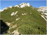 30
30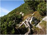 31
31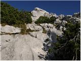 32
32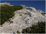 33
33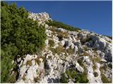 34
34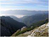 35
35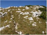 36
36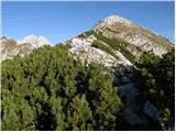 37
37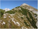 38
38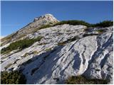 39
39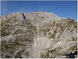 40
40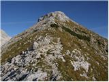 41
41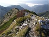 42
42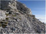 43
43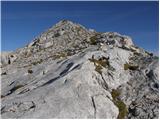 44
44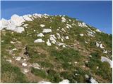 45
45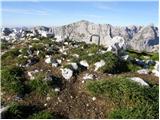 46
46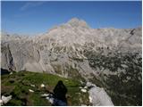 47
47
Discussion about the trail end of road on Pokljuka - Veliki Draški vrh
|
| Guest10. 09. 2006 |
izlet na veliki draški je zelo zanimiv zaradi lepega razgleda na triglav in druge gore:c
začetek poti iz studorskega prevala je naveren zaradi proženja kamenja zato moraš biti previden in lepo počasi hoditi
spust na drugo stran(proti Lipanci) je bil strm a skoraj boljši glede proženja kamenja  
|
|
|
|
| Guest22. 09. 2006 |
Opravil sem opisano turo in lahko povsem potrdim vse navedbe. Posebej velja opozorilo pri vzponu čez skalnat skok in še bolj pri prebijanju skozi ruševje. Še bolj zagoveden pa je na tem odseku spust. Velja biti zelo previden.
|
|
|
|
| Guest5. 08. 2007 |
Danes opravil turo in se popolnoma strinjam z zgornjima komentarjema. Prvi del poti je potrebno biti zelo previden in seveda paziti, da ne zgrešiš poti. Za začeten del poti skozi rušje so priporočljive dolge hlače. Spust sem opravil na drugo stran do poti na Lipanco in z nje direktno na Jezerca. Ta pot je res strma a dosti lažja kot s Studorskega prevala.
|
|
|
|
| Guest14. 08. 2007 |
Zanima me, ali je možen spust z Velikega Draškega vrha tudi na Vodnikovo kočo in koliko časa približno porabiš za tako pot od Studorskega prevala do koče. Hvala.
|
|
|
|
| Guest14. 08. 2007 |
Pot z Velikega Draškega vrha vodi na Srenski preval pod Malim Draškim vrhom in ni za tiste z vrtoglavico. Pot je ozka, izpostavljena, jeklena vrv je samo na nekaterih mestih. Je za izurjene planince.
|
|
|
|
| urshy22. 09. 2009 |
Ali morda kdo ve kakšna je pot iz Viševnika čez Mali in potem na Veliki Draški vrh?
|
|
|
|
| Miha817. 02. 2010 |
Izhodišče: Konec ceste na Pokljuki (1340 m)
Cilj: Veliki Draški vrh (2243 m)
Zanima me kakšna je kaj pot za jutri? Ali je uhojeno? Pozimi na Velikem Draškem vrhu še nisem bil, zato bi bil zelo vesel vaših informacij.
|
|
|
|
| Miha817. 02. 2010 |
Hvala za link in informacije. Zdej vem, da nikamor v visokogorje dokler ne bo varno.
Lep pozdrav
|
|
|
|
| colinbrooks24. 07. 2010 |
A trip to Veliki Draski Vrh
A magnificent circular tour on spectacular but easy paths with dramatic views including possibly the best view of Triglav from anywhere in the Julian Alps. Easily accomplished from Ljubljana in one day.
9.40-11.10. A first class road from just before Bled leads to the sport hotel at Pokljuka then past the new winter sports centre. From there follow the continuing macadam road for about 2km to the parking lot where the road ends at Rudno Polje. Total driving time from Lj 1.5h
11.10-11.50. Follow the track that leads gently upwards to the alpine pasture at Planina Konjscica where you can sample and buy the locally made cheese. Time 30min
11.50-1.15. After crossing the meadows at Konjscica, the path leads uphill through pine scrub to a large corrie with snow persisting until the end of June and with dramatic views of M. Draski Vrh and Visevnik. The path leading down from the ridge between them, that will be the route of descent later in the day, can be clearly seen. It looks much more forbidding, especially at the top, than it turns out to be in practice. The path that leads across the steep face of M.Draski Vrh can also be faintly seen if you know where to look. From the corrie the path then resumes its upward course before reaching the spectacular ridge at Studorski Preval which provides an excellent spot for lunch. Time 1.5h.
1.45-2.45. The non-markated path recommended in the guide heads off to the right [NW> in a clear passage through dense pine scrub and up a bulging rock face which is actually the start of a ridge leading to the hidden summit of V.Draski Vrh. The very beginning of this path is quite tricky, being on the edge of a steep descent to the left and is probably the most difficult part of the tour.
[Unmentioned in the guidebooks, and not readily visible on the ground, another path leads off roughly horizontally to the north from S.Preval, passing to the right and below the bulging rock race before gradually ascending to the col between Veliki and Mali Draski Vrh, from which an indistinct but easy path that will be used for descent in this trip (see below) goes off to the left to the summit of V. Daski Vrh.>
Once over the bulging rock face an easy path ascends the ridge to the summit with increasing views of the Triglav satellite of peaks. From the summit the view of the Triglav massif falling precipitously down into the deep Krma valley is unparalleled. On a clear day one could linger here for hours! Time 1h.
3.30-4.30. From the summit a winding and somewhat sporadic path leads down over easy ground and in a NE direction to the col between Veliki and Mali Draski Vrh. During the descent the path that leads spectacularly across the face of M.Draski Vrh can be clearly seen. It appears to enter dangerous territory at its end near the ridge between M.Draski Vrh and Visevnik but in fact there are no problems for experienced walkers especially as this part of the path is equipped with fixed ropes and pegs. For those who feel anxious a good path leads from the col to Studorski Preval [see above>. Time 1h.
4.30-5.15. The path across the face of M. Draski Vrh begins by ascending over easy ground. At the very start it runs along the edge of the precipitous cliffs that fall almost 1000m into the Krma valley, providing spectacular views of these [but keep away from the very edge as the ground is unstable here>. The path eventually narrows and continues horizontally before reaching the "difficult" section mentioned above. The drop-off to the right is steep but rarely precipitous, and for the careful walker this is a joyous, spectacular, and beautifully engineered path with dramatic views down to the corrie below. At the very end the path ascends to the left for about 100m up a steep shute of loose scree to a signpost on the summit ridge. This looks potentially dangerous from a distance, but in practice it is perfectly safe. Time 30 min.
5.30-7.40. After skirting the pinnacles along the ridge, in about 100m the path down to the corrie can be clearly seen. It is steep but not dangerous. From the corrie one retraces steps first to Konjscica [1h 15min> then to Rudno Polje [30 min>.
|
|
|
|
| techouse15. 12. 2014 |
S kolegom sva včeri zlezla najprej po eni grapci na Ablanco in nato še na Veliki Drgaški vrh. Razmere so bile kar resne, t.j. -5°C in sunki vetra do 96 km/h. Zarad ledenega prša je bla vidljivost enih slabih 10 m pa še očala so mi vmes 2x zmrzlna Nama je obema pošteno "speskalo" faco, doživetje pa enkratno
|
|
|
|
| mukl9. 11. 2015 |
S prijatelji smo prejšnji petek, 6.11. opravili to pot in jo potem nadgradili še s potjo na Viševnik.
Ker je bilo vreme naravnost kičasto in tako toplo za ta letni čas, nam je bilo kasneje žal, da nismo prej štartali in opravili najprej vzpon na Ablanco, potem Tosc, Veliki Draški vrh, nato Mali Draški vrh in na koncu še Viševnik, no, pa drugič...
Sicer pa prečudoviti razgledi in pogledi na očaka, Planika in dom na Kredarici sta bila tako blizu, da bi ju lahko prijel...
|
|
|
|
| nina42. 08. 2018 |
Ali je cesta od Rudnega polja do izhodišča za planino Konjščico že odprta?
|
|
|
|
| cBojan2. 08. 2018 |
Parkiraš 'lahko' na začetku ampak je ogromno hlodovine, cesta pa je uradno zaprta zaradi spravila lesa. Vsaj tako je bilo predvčeraj in včeraj.
|
|
|
|
| gulid236. 08. 2018 |
Do kdaj bo zaprta cesta do izhodišča: Konec ceste na Pokljuki. Nekje sem zasledil, da do 16.8.2018?
|
|
|
|
| nina46. 08. 2018 |
V nedeljo sem preverila stanje. Znak za zaporo je bil postavljen diagonalno (ne preko ceste, čisto umaknjen pa tudi ne) in se zato nisem upala peljati dlje od razcepa za pešpot na Uskovnico. Bolj pogumni pa so brez problema prevozili preostala 2 km in parkirali na koncu. Tudi informacija na spletni strani Pokljuke govori o občasni zapori. Sklepam, da je cesta ob koncu tedna odprta, ob delavnikih pa bodo očitno odvažali ogromne količine lesa, ki je že zložen ob cesti.
|
|
|
|
| Majdag2. 08. 2019 |
31.7... Prvič od konca ceste na Pokljuki in tudi zadnjič. Cesta polna udarnih jam, napolnjenih z deževnico. To še gre, nazaj del blatne ceste z globokimi kolesnicami tovornjaka in avtomobilov. Me je skrbelo, kako bom prišla čez ta drek. Je uspelo. Drugače pa je skalnati greben s Studorskega prevala zanimiv in pester. Veliko planik in Zoisovih vijolic je ob poti. Na vrhu pa megle, ki so se podile okoli vršacev. Lepa tura, razen ceste. https://jelenkamenmajdag.blogspot.com/2019/08/veliki-draski-vrh.html
|
|
|
|
| Majdag2. 08. 2019 |
.. Se opravičujem, Zoisove zvončice cvetijo ob poti.
|
|
|
|
| Enka28. 06. 2022 19:37:33 |
Pot na VDV lepo sledljiva in ravno prav zanimiva, da ni dolgčas . Po 3 letih spet deluje planšarija na Konjščici, kjer se je možno okrepčati in podpreti. Na Rudnem polju so znaki za prepovedan promet z motornimi vozili v smer proti Uskovnici in koncu ceste na Pokljuki. Včeraj sem, enako kot še kar nekaj drugih, sicer parkirala na izhodišču, a vprašanje je, koliko časa bo to še mogoče (na Konjščici pravijo, da naj zaenkrat prepoved še ne bi veljala, bo pa  )
|
|
|
|
| Alex19822. 09. 2022 15:51:56 |
Zanima me glede na to da pot ni označena...ali je dobro sledljiva...če mogoce kdo ve..hvala za odgovor
|
|
|
|
| garmont2. 09. 2022 16:03:08 |
Markirana ni samo od Studorskega prevala naprej. Točno na prevalu se obrneš desno in po potki, ki je vrezana v rušje nadaljuješ v smeri VDV. Nobenih težav z sledljivostjo ne boš imel.
|
|
|
|
| Alex19822. 09. 2022 16:27:57 |
Kako je pa kj z parkiranjem..ali je dovoljeno ali ne..mogoče kdo ve
|
|
|
|
| Hribolazec8114. 08. 2023 21:51:55 |
Pozdav, kako je s tem izhodiščem, se še da priti in parkirati?
|
|
|
|
| turbo14. 08. 2023 22:26:22 |
Seveda se pride in tudi parkirati se da na koncu, žalostno je le to, da je prepovedano. V eni sosednjih rubrik je bilo napisano kak dan nazaj in opremljeno s fotografijo....
|
|
|