Koča pri Savici - Podrta gora (approach on ridge from west side)
Starting point: Koča pri Savici (653 m)
Name of path: approach on ridge from west side
Time of walking: 7 h
Difficulty: difficult pathless terrain
Altitude difference: 1408 m
Altitude difference po putu: 1408 m
Map: Bohinj 1:25.000 (Sidarta)
Recommended equipment (summer): helmet
Recommended equipment (winter): helmet, ice axe, crampons
Views: 2.620
 | 6 people like this post |
Access to the starting point:
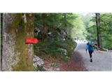
From the Ljubljana - Jesenice motorway, take the Lesce exit and follow the road towards Bled, Bohinjska Bistrica, Ribčevo Lazo, the Vogel ski resort and on to the cottage under the Savica waterfall. Park in the large parking lot, where parking fees are collected.
Path description:
The route from the Hut at the Savica Waterfall to the Home at Komna runs through the forest, along a former military causeway, where hikers have in practice made a number of shortcuts between the turns, but it still takes between 2 and 2. 5 hours to walk.
Taking Dom na Komni as the next starting point, from there head in the direction of the signs for Vogel, then after about 10 minutes walk at the first crossroads head for mountain pasture Govnjač (30 minutes on the sign). At the more or less abandoned mountain pasture Govnjač there are still a few remnants and ruins of the former military rear buildings from the First World War. There we will notice some red signs and direction markers, the important ones for our continuation being those for "Mahavšček" (Big Bogatin). The first option is marked as Mahavšček (shortcut), but it is quite overgrown, so after a more comfortable normal route over mountain pasture we reach almost as quickly the valley below an unnamed peak with an angle of 1792 m and after it the summit of Rob 1884 m. The first option is marked as "Mahavšček" (shortcut), but it is quite overgrown.
From this valley we have several options: either follow the marked trail to Mahavšček, which initially leads up the valley parallel to the ridge chain of the mountains and joins the ridge-marked trail of the Bohinj Mountains at the Kser saddle (1900 m), or follow the more or less visible paths and trackless trails (difficult for orientation) directly up towards Vrh Planje and the smaller saddle to the right of the summit, or to the more distinct Planja saddle (more difficult, you'll get lost sooner) between Vrh Planje and Tolminski Kuk.
The views along the marked ridge trail are magnificent, both to the right on the Tolmin side, and even more beautiful to the left, extending much further than Spodnje Komna, towards the mountains south-west of Triglav. The climb up to Tolminski Kuk from the west side is quite steep and strenuous, the path is more to the right, over rocky areas, with extensive scree to the left. Kuk is very scenic and the highest mountain of the Lower Bohinj Mountains, but it will take us about 3 hours to get here from Doma na Komni by a shortcut and a direct route to the Planja saddle, and about 4. 5 hours by a marked long-distance trail and over Kser.
From Tolminski Kuk onwards we descend for a bit, then climb up and quickly reach the friendly and spacious Zeleni vrh, which is actually green at the top. From here, we can already look out towards Podrtá hora and, from the west side, to its peak called Mali vrh. The marked trail from Zeleni vrh leads to the saddle between Zeleni vrh and Mali vrh, and then continues along the southern slopes below the peaks (Mali vrh, Podrta Gora, Konte vrh and an unnamed peak) towards the Škrbina saddle. From the saddle between Zeleni vrh and Mali vrh, we follow the trackless ridge directly up to Mali vrh, which we reach in a quarter of an hour. We look for the best passages in the slope, there are no particular difficulties or obstacles. There is no visible or beaten track, the terrain is more rough and rocky than grassy, the north side is distinctly precipitous, the south side is more friendly and less dangerous. From Maly Vrch we first descend a little, and then towards Podrti Gora we first see a short and sharp ridge and from its northern side a wall or slab about 6 m high (with an intermediate stand), which offers enough holds and places to climb from this side (I - II, about 6 m, 60⁰), dangerous mainly because of the exposure. If you are not skilled in this, a detour on the south side and a little lower than the ridge is also possible and, above all, easier.
Once over the wall, exit onto the ridge below the west side of Podrta Gora, which is about a metre wide at the top, and then from there head up a little right at first, and in two or three keys (50 m), in easier climbing, overcome the steep and crumbly continuation, where it is no longer exposed. There is a top, flatter section. At the top of Podrta gora there is a small metal pole with an engraved inscription (for a stamp): Podrta gora 2061 m.
From Tolminski Kuk via Zeleni Vrh and Mali Vrh to Podrta gora is about 1 hour walk.
For the descent it is recommended to return to Mali vrh along the same route, although I do not recommend climbing from the ridge over the rock slab or wall without belaying (20 m of climbing rope and approx. 3 m for a loop are sufficient). If you don't have this, it is better to descend from the saddle between the summit and the ridge to the south side and there find the appropriate passages to the marked route.
The descent from Podrta gora along the east ridge is more difficult, longer and more exposed, the difficulties are avoided on the south side, you reach the saddle below Vrh Konte, from where there is a logical continuation along the ridge cut to Vrh Konte, but the obstacles and difficulty (at least II) here require adequate knowledge and more training and experience in ridge traversing. If you want to go round, you can continue towards the Škrbina saddle (1910 m) (crossroads of several marked trails), and from there turn left downhill. The marked trail leads under Vrh nad Škrbina to the place where it is joined by the trail from Konjski sedlo from the direction of Vogel, if we continue along the marked trail around Mohorj (1847 m), with beautiful views of Lake Bohinj in between, we will need to cross the abandoned mountain pasture After Migovec, back to Komna in about 3 hours, so all together about 8-9 hours, an hour less if you take the shortcut down the trackless road to the left of Mohorje (marked Tolminska lakev on the map, where winter hiking trails pass in winter) to the Krošnja valley, where you then join the marked trail at the clearing: Vogel - Govnjač. However, this choice is subject to a warning about the very difficult trackless path and the overgrowth of tall dwarf pines, so I do not recommend it in summer and in the mainland.

Pictures:
 1
1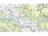 2
2 3
3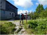 4
4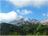 5
5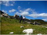 6
6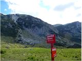 7
7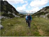 8
8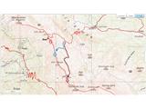 9
9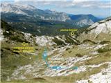 10
10 11
11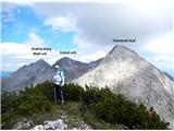 12
12 13
13 14
14 15
15 16
16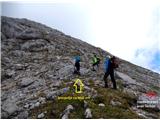 17
17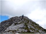 18
18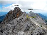 19
19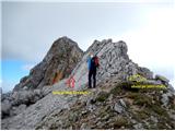 20
20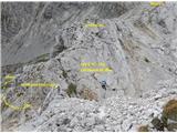 21
21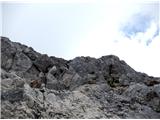 22
22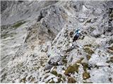 23
23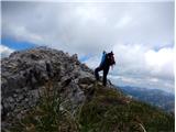 24
24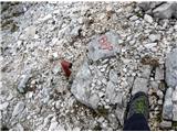 25
25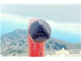 26
26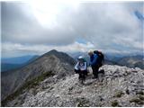 27
27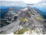 28
28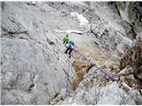 29
29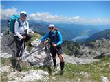 30
30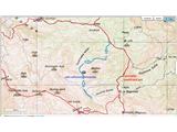 31
31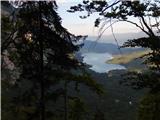 32
32
Discussion about the trail Koča pri Savici - Podrta gora (approach on ridge from west side)
|
| gams116. 06. 2017 |
popravek k sliki 19: namesto napisa Vrh Konte mislim, da mora biti Vrh Škrbine;  sicer pa lepo in nazorno opisano.
|
|
|
|
| garmont17. 11. 2018 |
Odličen in predvsem realen opis. 
|
|
|