End of road on Pokljuka - Mali Draški vrh
Starting point: End of road on Pokljuka (1340 m)
| Lat/Lon: | 46,3386°N 13,9045°E |
| |
Time of walking: 2 h 35 min
Difficulty: difficult unmarked way
Altitude difference: 792 m
Altitude difference po putu: 800 m
Map: Triglav 1:25.000
Recommended equipment (summer): helmet
Recommended equipment (winter): helmet, ice axe, crampons
Views: 12.749
 | 1 person likes this post |
Access to the starting point:
a) Leave the Gorenjska motorway at the exit for Lesce, then follow the signs for Bled and Pokljuka. Continue through Gorje and past the ski resort Zatrnik to Rudni Polje on Pokljuka, where there is a large pay parking lot and a military barracks and shooting range nearby. From here, continue straight along the macadam road, which leads us a little further to a crossroads, where we continue to the right (Uskovnica on the left). Follow this road to the former parking lot Za Ribnico, which is at the end of the road (there are mountain signs for mountain pasture Konjščico).
After the new parking at the end of the road is forbidden, so we park already at Rudne polje, which lengthens the route by about 40 minutes, but it is more convenient to choose the marked trail, which starts already at Rudne polje.
b) From Železniki or Podbrdo, take the road to Bohinjska Bistrica and then continue in the direction of Bled. Shortly after the Petrol station, which is located just after Bohinjska Bistrica, turn left in the direction of Pokljuka and Jereka. The road climbs steeply at first, then gradually flattens out behind Koriti, leading to a junction by the bus station, where you continue right in the direction of Pokljuka, Koprivnik and Jereka (straight ahead Srednja vas). Just after the crossroads we arrive at Jereka, and from the crossroads in front of the church we continue straight on towards Pokljuka (left Podjelje). After Jereka the road starts to climb steeply again, and higher up it levels off and continues along the Mrzle potok. When you join the road from Bled, go left and drive to Rudno Polje, where there is a large pay parking lot, and also a military barracks and a shooting range nearby. From here, continue straight along the macadam road, which leads us a little further to a crossroads, where we continue to the right (Uskovnica on the left). Follow this road to the former parking lot Za Ribnico, which is at the end of the road (there are mountain signs for mountain pasture Konjščico).
After the new parking at the end of the road is forbidden, so we park already at Rudne polje, which lengthens the route by about 40 minutes, but it is more convenient to choose the marked trail, which starts already at Rudne polje.
Path description:
From the former parking lot at the end of the road, follow the wide and initially ascending cart track towards mountain pasture of Konjščice. The cart track, which goes immediately into the dense forest, is quickly laid and after a few minutes of easy walking turns into a footpath which continues along the left bank of the Ribnica stream. When the path is quite close to the stream, it turns slightly to the right and climbs steeply. Higher up, the path lays down and leads out of the forest to the lower edge of the vast Konjščice River. Here the path turns slightly to the left, crosses a small stream and, after a few further steps, leads us to the cheese cottage at mountain pasture Konjščica.
From the cheese cottage, continue along a pleasant path which, after a few minutes of gentle ascent, leads to the upper edge of mountain pasture. Here the path goes into lane of dwarf pines and scrub and gradually starts to climb more steeply. In the upper part of the ascent towards Jezerce, the path from Rudno Polje joins us from the right, and we continue straight on the moderately steep path, which leads us within a few minutes of further walking to Jezerce, where the path is laid. There are also signposts pointing to the right behind the "Viševnik" signs.
At first, walk along the path towards Maly Draškemu vrh. The path then turns slightly to the right and begins to climb up the valley between Mali Draški vrh and Viševnik. Initially, the path climbs up the left side of the valley, but in the upper part it turns slightly to the right and then climbs along a steep slope to Srenjski preval.
From the Srenjski Prevala, continue left along an unmarked and less visible path, which begins to climb steeply up and along an unmarked gully (sharp left Studor preval). The path climbs slightly to the right of the gully in the lower part, then briefly switches to the left (direction of ascent) side of the gully for a short distance. Higher up, the gully climbs steeper and the path starts to disappear. Continue up the ravine steeply (with caution because of the large drop) and you will see some very old and completely faded markings along the "way". After a good 20 minutes of climbing, we reach a precipitous ridge, which opens up a beautiful view of the Krme valley and the peaks that surround it. From here, you can climb to the nearby eastern peak, which is a few metres away by an easier climb on an exposed ridge, or to the slightly more distant, but a few metres higher, western peak. This is reached by descending a little, then climbing a fairly exposed ridge in a few 10 steps to reach the summit.

Pictures:
 1
1 2
2 3
3 4
4 5
5 6
6 7
7 8
8 9
9 10
10 11
11 12
12 13
13 14
14 15
15 16
16 17
17 18
18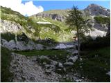 19
19 20
20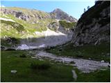 21
21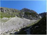 22
22 23
23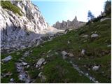 24
24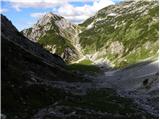 25
25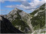 26
26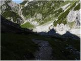 27
27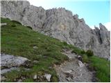 28
28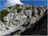 29
29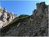 30
30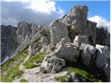 31
31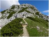 32
32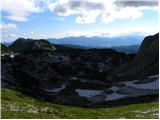 33
33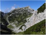 34
34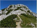 35
35 36
36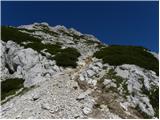 37
37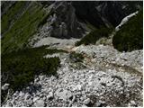 38
38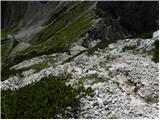 39
39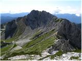 40
40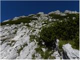 41
41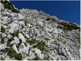 42
42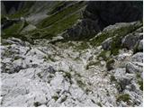 43
43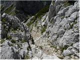 44
44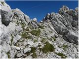 45
45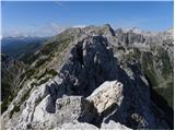 46
46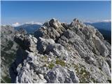 47
47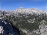 48
48
Discussion about the trail End of road on Pokljuka - Mali Draški vrh