Starting point: The Kot Valley (950 m)
| Lat/Lon: | 46,4157°N 13,8977°E |
| |
Time of walking: 2 h
Difficulty: partly demanding unmarked way
Altitude difference: 593 m
Altitude difference po putu: 600 m
Map: Triglav 1:25.000
Recommended equipment (summer):
Recommended equipment (winter): ice axe, crampons
Views: 10.334
 | 1 person likes this post |
Access to the starting point:
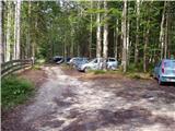
Leave the Gorenjska motorway at the Hrušica exit and follow the road towards Kranjska Gora. Just before the village of Dovje, the road branches off to the left and leads to Mojstrana (Vrata, Kot and Krma). Follow the road in the direction of the village of Radovna and the valleys of Krma and Kot. The relatively steep road then leads us past the TNP signboard, after which the road soon lays down and leads us to a crossroads where a dirt road branches off to the right into the Kot valley (straight ahead to Radovna and Krma). This sometimes slightly worse road is then followed to a parking area, where you will also see mountain signs.
Path description:
From the parking lot, continue along the wide cart track (worse road), which after a few minutes of easy walking leads to a turning point (parking is not recommended here). Here, the marked path towards Stanič's home descends slightly and crosses the torrent, and we continue slightly to the right on the cart track, which climbs gently up the right side of the torrent (left bank). After about 3 minutes' walk from the turning point, the unmarked hunting trail branches off to the right from the cart track, and we continue our climb on this trail. The path, which initially climbs steeply, leads us quickly to a small stream, along which we climb for a short time and then cross it. On the other side of the stream, the path climbs relatively steeply in numerous bends and after a while leads us out of the forest onto a rather overgrown grassy slope. The path from which we have views mainly of Macesnovec, Luknja Furnace and Rjavina is again hidden in the forest higher up. When the path leads us to a nondescript side ridge, we can climb in a few steps to a beautiful viewpoint from which we can see the peaks above the Kot and Krma valleys.
On an inconspicuous ridge, the path turns left (not along the ridge) and leads us in a cross-climb to a small grassy scree field surrounded by numerous larch trees. The path then goes into the forest again, turns right at a higher altitude and after a slightly longer cross-climb leads us to the main ridge, where we continue to the right (sharp left Požgana and Rušnata Mlinarica).
Continue walking along the ridge through the forest for a while, and then the path leads us out of the forest to a scenic peak.

Pictures:
 1
1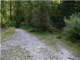 2
2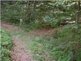 3
3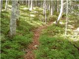 4
4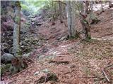 5
5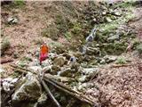 6
6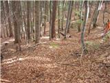 7
7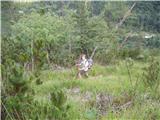 8
8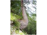 9
9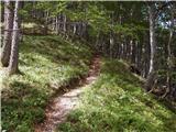 10
10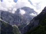 11
11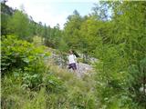 12
12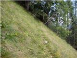 13
13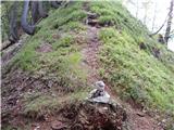 14
14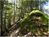 15
15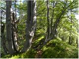 16
16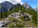 17
17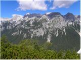 18
18
Discussion about the trail The Kot Valley - Požar
|
| viharnik28. 07. 2011 |
že pred desetletjem sem hodil sem gor na Požar iz Kota.Bilo je zgodaj spomladi, ko je greben že okopnel, pogorje Škrlatice pa še povsem v snegu.Razgled od tod onkraj Vrat je nepozaben in edinstven.Vidi se celotno pogorje od Stenarja do Vrtaškega vrha, vseskozi pa te na poti spremlja samo narava in gorski mir.
|
|
|
|
| pok luka20. 08. 2011 |
Bil danes iz Kota na Požar pa po grebenu do črne gore in nazaj po cesti do Legnarjevega rovta in lahko rečem le eno noro lepo razgledi kot je opisal Yiharnik plus Cmir in Rjavina kot na dlani. Kdor si zaželi miru in razgledov toplo priporočam na vsej poti nisva srečala niti enega človeka razen treh jurčkov ki pa bodo juha postali
|
|
|
|
| melitad20. 05. 2012 |
Ta vikend so se lovci verjetno zelo posvetili tej poti, ker je od Kota navzgor prav prijetno razširjena in suho resje lepo potrgano, da ne zožuje steze. Je pa treba res gledati pod noge, ker sem srečala dva modrasa, oba nekje na tretji tretjini poti.
|
|
|
|
| Jusk8. 10. 2020 |
Greben Črne gore me je že dolgo mikal,zato sem se danes odločil za to pot. Hojo sem začel na Kosmačevem prevalu,šel po dolini Kot in naprej po poti na Požar. Na začetku luštna pot,potem pa kar strma in ozka po nešteto okljukih  skoraj celo pot se je slišalo bučanje Kotovih slapov,na neki točki med potjo se tudi vidi en slap. Na Požaru kratka pavza,potem pa po grebenu do bivaka in dol do izhodišča. Med potjo do bivaka malo "pretepanja" z ruševjem,na splošno pa pot ok tudi od bivaka dol je pot večinoma dobro sledljiva. Lp
|
|
|
|
| ljubitelj gora8. 10. 2020 |
Potem sva se srečala. Tud danes pozno popoldne le da najprej na Črno goro in naprej na Požar.
|
|
|
|
| galebka13. 07. 2021 22:42:13 |
Pot na Požar je v enem delu zelo otežena zaradi večje količine podrtih dreves ... Tam je izjemno težko slediti, kje je pot in hitro jo človek med plezanjem čez podrta drevesa izgubi izpred oči. Ko pa nisi več na poti, lahko pa samo na pamet grizeš kolena v veliko strmino ... Priporočam torej natančno opazovanje poti ali pa kakšno drugo destinacijo, dokler se ta drevesa ne pospravijo oz. se vsaj pot očisti (če se sploh bo kdaj?). Lp
|
|
|
|
| djimuzl14. 07. 2021 18:08:28 |
Dreves prav gotovo ne bodo "pospravljali", mogoče bodo z žago kje olajšali prehod.
|
|
|
|
| tango29. 10. 2022 19:15:56 |
Štartala sva na Kosmačevem prevalu in namen sva imela iti na Macesnovec, a naju je zaradi spolzke in ves čas senčne poti ( vsaj do studenca)premamil od sonca žareč greben od Požara pa do Črne gore. Izbira prava, ampak spust s Črne gore naju je kar nemučil, saj zaradi odpadlega listja že tako slabo vidna pot večkrat izgine in midva, kljub temu da sva bila na Črni gori že kar nekajkrat, sva jo mahnila preveč v desno, potem pa je šlo bolj na hojladri. Še to, cesta v Kot je pa bolj gladka kot če bi bila asfaltirana in ob čudovitem vremenu tako ni čudno, da je bilo na parkirišču v Lengarjevem rovtu povsem polno.
|
|
|
|
| BorStenar19. 11. 2022 18:29:21 |
13. novembra sem šel na Požar po tej poti. pot je v dobrem stanju, sicer pri potoku je jeseni orientacija lahko težka (listje zakriva pot do prehoda čez potok (ki ga zares ni  ) a se dobro vidna pot odpre na drugi strani struge.) Drugače tura super razgled še bolj 
|
|
|
|
| G3419. 11. 2022 19:40:15 |
Ko smo mi odšli tja je bil odličen pogled na gore v okolici. Po celi poti nismo videli niti enega človeka
|
|
|
|
| G3420. 11. 2022 16:49:36 |
Včasih je pot tudi izpostavljena ampak načeloma je super.
|
|
|
|
| navdušena22. 06. 2023 09:03:33 |
Je letos že šel po tej poti? Kako je s podrtimi drevesi?
|
|
|
|
| BananaBronson22. 06. 2023 09:07:30 |
Prehodile smo jo prejšnji teden. V srednjem delu je nekaj podrtih dreves, ampak prehod ni problematičen. Predvidevam, da se da okrog, me smo se pa za skromnimi možici zbasale tudi malo med njimi. Tudi pot na Požar s Črne gore je OK.
|
|
|
|
| navdušena24. 06. 2023 16:06:58 |
Pot prehodila danes. Podrta drevesa res niso problem. Zelo lepo je bilo!
|
|
|