Zadnjica - Triglav (Kugyjeva pot)
Starting point: Zadnjica (650 m)
| Lat/Lon: | 46,3824°N 13,7604°E |
| |
Name of path: Kugyjeva pot
Time of walking: 7 h 30 min
Difficulty: very difficult marked way, difficult unmarked way
Altitude difference: 2214 m
Altitude difference po putu: 2214 m
Map: Triglav 1:25000
Recommended equipment (summer): helmet, self belay set, ice axe
Recommended equipment (winter): helmet, self belay set, ice axe, crampons, lamp
Views: 4.580
 | 8 people like this post |
Access to the starting point:
From Bovec, follow the Trenta valley to Trenta. After the centre of the settlement, the road descends to the bridge over the Krajcarca River and after 350 metres reaches the first (last from the route of Kranjska Gora) bend of the Vršiška Road. At this sharp left turn, a macadam road (left from the route of Kranjska Gora) branches off to the right into the valley of the Zadnjica River, which leads to a marked parking area after 150 metres.
Path description:
From the parking lot, continue along the road, which takes you past a few houses (mainly at weekends) and leads you in about 15 minutes to a place where a road branches off to the left up the hill (there used to be a parking lot at the crossroads, but now parking is prohibited).
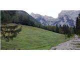
Continue straight on the road (on the upper road you will reach the bottom station of the cargo cableway and the start of the mulatier leading to Pogačnik's home) in the direction of Dolič, Luknja and Prehodavci. Initially, the gently sloping road, which leads us across the meadows and higher up through the forest, is followed to its end, where it narrows into a mulatier and leads to a bridge over the Zadnjica River (altitude 1000m, it takes about 1 hour to get here). Here, to the left, we have a view of the Luknja Pass, above us (to the south) looms the Kanjavec, with its mighty wall, and a little to the right is a view of the Zadnjiški Dol, along which the path to Prehodavce winds. Here is the last chance to get a refreshing drink of water.
The ascent continues along the mulatier, which initially climbs through the forest, but higher up, in a number of switchbacks, overcomes steeper slopes and is oriented towards Luknja. At a height of about 1500m, we reach a crossroads where our mulatier turns to the right (towards Dolič), and the path straight ahead branches off towards Luknja. The mulatier, cut into the rock, continues to wind over the precipitous slope and the higher we go, the more interesting are the views of the many serpentines below us and the grassy slopes of Pihavec opposite. A little higher up, the path crosses a wide, craggy ravine, making a sharp right turn to the other side of the ravine (this ravine is the source of the valley heading up towards Zaplanja, which we will continue to follow, but for now we continue on the mulatier), where it continues through a larch forest in the keys a little higher up. When the mulatiera flattens out a little (heading south), look out for some stone steps on the left, which direct you from the mulatiera upwards to the left towards the ruins of the former Italian outpost of Gemona. It is just a stone's throw above us and, if you walk a few steps further along the mulatiera, it is clearly visible. Here, at about 1780m, is the start of the Kugy Route. From the ruins of Gemona onwards, we cross several scree slopes on the steep slope of Zelenice, where the trail trail occasionally gets lost. Keep the altitude or slightly ascend as you cross the scree. Further on, the path below the steep slopes of Zelenice is again better trodden. At an altitude of about 2000m, from Zelenice, turn left northwards to cross the valley. Here the trail is more difficult to follow, but the terrain is easy to traverse, with grass predominating. Soon we see a large scree field and a valley head above us. Actually, there are two valleys. The right one, more distinct and narrower, and the left one, just above us. Both valleys are connected by a large scree slope, which we use to orient ourselves. It is important to orientate along the left edge (upwards) of the scree. Just to the right of the left edge of the scree you can see a slightly overgrown lane of grass. After about 100 metres, this will lead to the key point of the Kugy route, i. e. to the old rail-track, which is the easiest passage from this valley to the ridge Plemenice, where the marked route runs. The crossing over the rocky edge is the easiest here. Three sections of the crampons, although old, are still fixed into the rock, but do not give a sense of security. Fortunately, the terrain itself is not so exposed that they are strictly necessary. Further on, the trail is again more traceable and well trodden. In a few minutes, the path leads us to picturesque steep grassy terrain, and then on to the very precipitous edge above Koriti. From the grassy edge, look straight down on Luknja. From here the track continues along the grassy ridge (NE direction) for another 200m as the crow flies, then turns right to the east, where you walk along the plateau-like high mountain karst. After 300 m, the path leads to a marked trail that goes from Luknja to Triglav. A few minutes further along the marked path and you can admire the famous Sphinx up close from the edge of the North Triglav Wall. From here on, follow the markings leading to the top of Triglav via the western Triglav plateau and Triglavska škrbina. The weight of the description refers to the unmarked part of the route between the mulatier to Dolič and the protected path over Plemenice (as of September 2020). Due to the sometimes poorer traceability of the trail itself, in some places also pathless, I advise against the trail in fog due to the difficulty of orientation. I also advise against descending in wet weather due to the steep grassy areas in places.

Pictures:
 1
1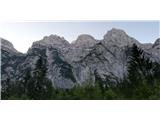 2
2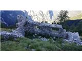 3
3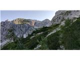 4
4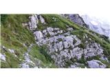 5
5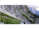 6
6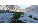 7
7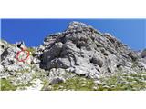 8
8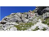 9
9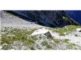 10
10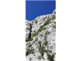 11
11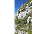 12
12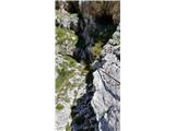 13
13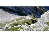 14
14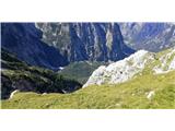 15
15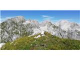 16
16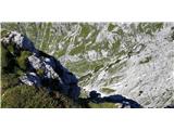 17
17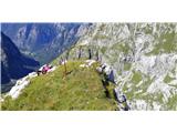 18
18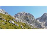 19
19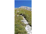 20
20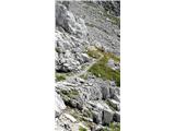 21
21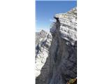 22
22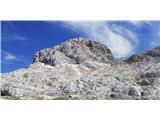 23
23
Discussion about the trail Zadnjica - Triglav (Kugyjeva pot)
|
| darinka413. 04. 2021 12:01:17 |
Nekoč je bila verjetno označena - markirana.
|
|
|
|
| piotr13. 04. 2021 13:54:37 |
Dobro opisana pot, ki je v Brilejevem Priročniku za planince iz l.1951 omenjena kot slabo markirana. 
|
|
|
|
| Jernej96813. 04. 2021 14:22:21 |
Opisana je tudi v planinskem vodniku Rudolfa Badjure "Na Triglav", izdanem leta 1913. Takrat je bila pot gotovo bolj "sveža" in dobro označena. Kugyju pa bi bila gotovo bolj všeč taka, kot je danes, ko jo narava spet spreminja v prvotno obliko.
|
|
|
|
| simon7913. 04. 2021 15:10:03 |
Najlepša pot na Triglav. Samotna. Prvobitna. Grem vsako leto, prvič sem zgrešil jeklenice, še ni bilo tega opisa. Če hodiš počasi in zelo pozorno, lahko skoraj ves čas slediš obledelim markacijam, najmanj 30 sem jih naštel ob zadnjem obisku. Upam, da pot taka ostane tudi v bodoče.
|
|
|
|
| trdi13. 04. 2021 16:54:40 |
Super za ta opis, pot je vrisana tudi v Locus map, ne vem pa kako zahtevna je, da bi si upal po njej.
|
|
|
|
| Jernej96813. 04. 2021 23:28:37 |
Simon, se strinjam. Mene je pritegnila, ko sem z Loga v Trenti opazoval to zelenkasto dolino, po kateri pelje pot, ki res daje vtis nekega naravnega prehoda proti vrhu Triglava. Na tej poti je mirno tudi na višku sezone. Prav želiš si koga srečat  .
|
|
|