ZipLine Kanin before Planina Krnica - Vratni vrh (Military mule track on Vratni vrh)
Starting point: ZipLine Kanin before Planina Krnica (1176 m)
| Lat/Lon: | 46,34885°N 13,5052°E |
| |
Name of path: Military mule track on Vratni vrh
Time of walking: 2 h
Difficulty: easy marked way, partly demanding unmarked way
Altitude difference: 807 m
Altitude difference po putu: 807 m
Map:
Recommended equipment (summer): helmet
Recommended equipment (winter): helmet, ice axe, crampons, lamp
Views: 1.450
 | 5 people like this post |
Access to the starting point:
We arrive at Bovec, where we have to turn into the old part of the centre and here, at the roundabout, we turn up the hill towards Plužna and Station B. When you reach the fork with the dirt road, turn left along the dirt road and continue towards Station B. When you reach it, continue towards the valley Cirque, where you park by the Zip line. You can also go to mountain pasture Cirque but it is a bad road at the beginning.
Path description:
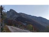
From the Zip Line parking lot, follow the road towards mountain pasture Cirque. Here turn left up the marked valley path Cirque. Continue along this for about 15min, when you need to find an unmarked track or a slightly higher mulatier which branches off to the right below the base of the beginning of the ridge of Vratni vrh. The mulatier runs above the forest tongue. When you reach the saddle above the forest tongue, turn left over the rocks and a little further round the corner with the steel cable. Here a steep grassy valley opens up, along which the mulatiera runs up to two potholes, where the path for Plešivec branches off to the right, and between the two potholes we turn left into the grassy slope up towards Vratni vrh (a pothole with occasional cairns). Keep slightly to the right, so that we reach a ridge to the right of the summit of Vratni vrh (Vratni vrh). As you climb over a slight rise, you see a window on Vratný vrh. Continue left along the slightly exposed ridge to cairn at the top.

Pictures:
 1
1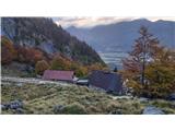 2
2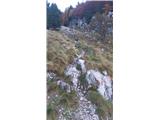 3
3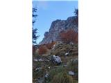 4
4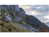 5
5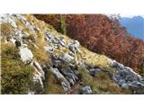 6
6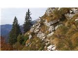 7
7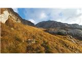 8
8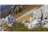 9
9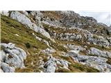 10
10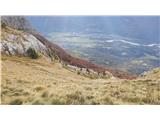 11
11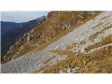 12
12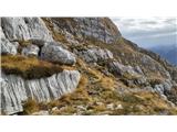 13
13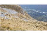 14
14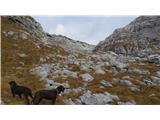 15
15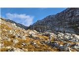 16
16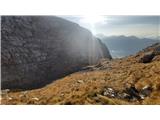 17
17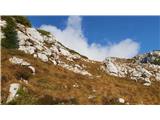 18
18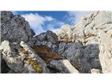 19
19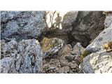 20
20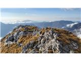 21
21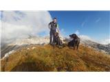 22
22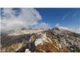 23
23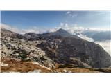 24
24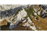 25
25
Discussion about the trail ZipLine Kanin before Planina Krnica - Vratni vrh (Military mule track on Vratni vrh)
|
| mirank14. 06. 2022 21:08:34 |
Opisano pot sem prehodil dvakrat le v obratni smeri. Skoraj prepričan sem, da je del med gozdnim jezikom na sl 5 in sl 6 ter 7, nekakšna bližnjica.
Ta prava povezovalna mulatiera po mojem poteka malo niže?
|
|
|
|
| darinka416. 11. 2022 14:24:57 |
Katera smer je boljša za vzpon in katera za sestop? Kar je bilo videt zadnjič je bila kar strma z druge strani. Midva sva ga zaobšla, ker sva bila že preveč desno proti Plešivcu.
|
|
|
|
| mirank16. 11. 2022 20:23:42 |
Mi smo tam vedno sestopali; enkrat z Lope in 2x s Črnele. Kar malo spotoma po grebenu od Pri banderi sem in proti Plešivcu dol. Kaj ti misliš pod druga stran
|
|
|
|
| darinka416. 11. 2022 21:51:53 |
Mislim na tisti strani kjer gre pot s Prevale na Rombon. Se vidi cik cak pot na Vratni vrh.
|
|
|
|
| dprapr17. 11. 2022 08:55:40 |
Tam je travnati prehod Naklo, v škrbino med Jelenkom in Vratnim vrhom. Po njem sicer nisem hodil, vendar od zgoraj dol ne zgleda nič posebnega.
|
|
|
|
| BT8817. 11. 2022 11:32:54 |
Če maš vreme orientacia ni problem, sam greššš mal gor dol sem in tja  ni lepših koncev zame tako poleti kot pozimi je tole top
|
|
|
|
| mirank17. 11. 2022 19:02:19 |
Tisti prehod, ki ga omenja Dprapr sem vsakič, ko smo šli mimo, gledal od spodaj z malo hojene mulatiere. Kako zgleda od zgoraj niti nisem bil pozoren, ma če bi že šel tam je po mojem lažje proti gor.
|
|
|
|
| darinka417. 11. 2022 19:51:32 |
Hvala vsem za komentarje. Smo šli danes vsi trije. Ko je prejšnje dni snežilo, je sneg zaneslo tudi v ta žleb Naklo. Nam je šla hoja prav v redu. Smo bili kar previdni. Vreme je bilo kakršno je pač bilo. Šli smo do vrha. Si ogledali naravno okno pod vrhom . Če bi bilo lepše vreme, dežja niti ni bilo , le visoka oblačnost , bi šli še do Plešivca in Jelenka. Smo sestopili po drugi strani po mulatjeri na B postajo kaninske žičnice. Vseeno brez navigacije nikar po teh brezpotnih koncih. Žleb pa je zanimiv. Šli smo bolj po občutku, ker pot zaradi trav in snega ni vidna. Pa še čas hoje bi rekla , da sta dve uri nekoliko premalo. No ja kot za koga.
|
|
|