Starting point: Zgornja Sorica (950 m)
| Lat/Lon: | 46,2273°N 14,029°E |
| |
Time of walking: 1 h 30 min
Difficulty: easy marked way
Altitude difference: 597 m
Altitude difference po putu: 597 m
Map: Škofjeloško in Cerkljansko hribovje 1:50.000
Recommended equipment (summer):
Recommended equipment (winter): ice axe, crampons
Views: 9.523
 | 1 person likes this post |
Access to the starting point:
From Železniki head towards Soriška mountain pasture. At the crossroads at Zgornja Sorica, turn left towards Petrovy Brda and Tolmin and then park 50 m later in a suitable space at the next crossroads.
From Podbrdo drive towards Železniki, but only as far as the village of Petrovo Brdo, where continue left in the direction of Soriška mountain pasture. Follow this road to Zgornja Sorica, where you park only about 50 m before the crossroads where the road to Železniki branches off to the right.
Access from the Bohinj direction is also possible.
Path description:
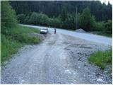
From the starting point, focus on the ascending macadam road, which after a few steps leads to a crossroads. Continue along the slightly steeper cart track, which climbs between the two roads (the right-hand road leads to the nearby quarry). The initially relatively steep cart track soon lays down and leads us over a scenic slope (overloking Sorica) to a place where we get on a marked path (you can also take the marked path to here, which starts right at the crossroads, but I advise against climbing it due to the overgrowth).
Continue the ascent on a well-marked footpath, which, higher up, is quite close to the road to Soriška mountain pasture.
Continue straight ahead in the route Lajnar (right on the road Soriška planina) along the path, which is becoming increasingly overgrown. The well-marked path, which climbs the slopes of Dravh, leads us higher up to the edge of the forest, where we see a dilapidated shepherd's hut.
Further on, the path passes out of the forest onto a heavily overgrown grassy slope (the markings also become more sparse), after which we climb along a barely visible path. The overgrown path crosses some wet, slip-prone slopes in the upper part, then leads to the main ridge where the overgrowth ends.
Continue right (left Lajnar) along the ridge path, and after 10 minutes of further walking this leads to the summit, which is open to the view.

Pictures:
 1
1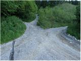 2
2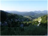 3
3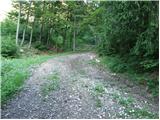 4
4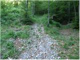 5
5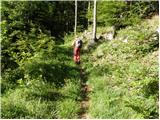 6
6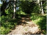 7
7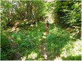 8
8 9
9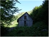 10
10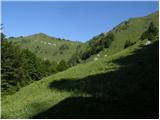 11
11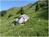 12
12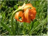 13
13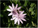 14
14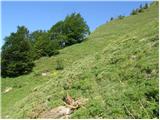 15
15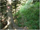 16
16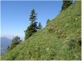 17
17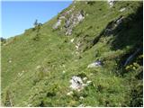 18
18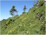 19
19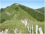 20
20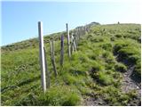 21
21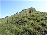 22
22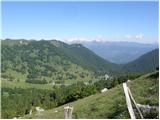 23
23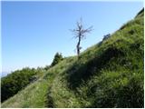 24
24 25
25
Discussion about the trail Zgornja Sorica - Dravh
|
| rober17. 06. 2009 |
Lepo...sploh najbrž zato ,ker ni veliko ljudi,izlet za dušo...
|
|
|
|
| Tadej17. 06. 2009 |
Pot je res samotna in obdana s številnim cvetjem, tudi razgled je lep. Nekoliko manj prijetno pa je vzpenjanje po visokih travah, sploh če je ta mokra.
Možen je sestop po običajni poti do Litostrojske koče in nato deloma po cesti, doloma pa po peš poti nazaj do izhodišča.
|
|
|
|
| grega_p7. 11. 2009 |
S kolegico sva jo danes mahnila gor iz Zg. Sorice, vendar nisva predvidela takih zimskih razmer, tako da se je na vrhu že pošteno vdiralo, rekel bi, da je okrog 30cm dokaj suhega snega zgoraj. Pa tudi razgleda zaradi megle na žalost ni bilo, je pa vsaj telo pošteno zadihalo. Dol pa na Soriško pl. po smučiščih mimo borderjev in po cesti nazaj do avta. Vse skupaj okoli 3h v teh razmerah.
Hvala predhodniku za gaz, drugače bi jo mahnila kar po običajni poti, kjer pa bi zaradi strmih trav verjetno naredila dva korak naprej enega ali več pa nazaj:-)
Srečno vsem!
|
|
|
|
| viharnik7. 11. 2009 |
Vajin predhodnik je bil verjetno,kdo drug kot afriški Janez,ki je ljubitelj turnega smučanja-Gore ljudje net.
|
|
|
|
| vespuci20. 05. 2012 |
Za vse,ki se odpravljate na zgoraj opisano pot,naj povem,da jo zaradi podrte poti predno stopimo na greben-dež je urezal 2 m široko grapo,ne priporočam.
|
|
|
|
| Habič Borut21. 01. 2013 |
Pot ni prav nič nevarna le potrebno je nekoliko popazit. Prehodili smo jo 2. januarja letos.
Borut
|
|
|