Zadnjica - The lake Zgornje Kriško jezero
Starting point: Zadnjica (650 m)
| Lat/Lon: | 46,3824°N 13,7604°E |
| |
Time of walking: 4 h 45 min
Difficulty: easy unmarked way
Altitude difference: 1508 m
Altitude difference po putu: 1555 m
Map: Triglav 1:25.000
Recommended equipment (summer): helmet
Recommended equipment (winter): helmet, ice axe, crampons
Views: 25.477
 | 6 people like this post |
Access to the starting point:
From Kranjska Gora, drive over the Vršič pass towards Bovec or vice versa, but only as far as the 50th serpentine of the Vršiška or Ruska road (near the village of Trenta). Here you turn onto a side road, and then park for a few 100 metres in a roadside parking lot.
Path description:
From the parking lot, continue along the road, which takes you past a few houses (mainly at weekends) in about 15 minutes to a place where the road splits into two parts (there used to be a parking lot at the crossroads, but now parking is prohibited).
From the old parking lot, take the road to the left in the direction of Pogačnikov dom na Kriških podih (the road to the right leads to Prehodavci and Dolič). After 15 minutes of further walking, the road leads to the bottom station of the cargo cableway, where it ends.
The ascent continues along a marked footpath (mulatjeri) which climbs moderately through the forest. The path climbs above the valley of the White Stream and quickly leads to very steep slopes (risk of falling rocks), over which a very wide footpath leads. The path then crosses the Veliki Presek ravine, after which you reach a short exposed ledge, which you cross with the help of a rope. The path then returns to the forest, where it climbs moderately in a number of switchbacks. A little further on, the path leads us under a small overhang, where we can see a number of sticks that hikers put up to keep the rock from rolling down into the valley (the sticks are put up more as a joke than for real). The path then crosses a couple of small ravines, and then leads us past a chapel to a larger ravine. With a little care (easy) we cross the aforementioned ravine, after which we climb up to a pleasant resting place (two benches along the way) within a few minutes of further walking. Next, cross another larger ravine (in early summer, the possibility of snowfields), and then the path returns to the forest. Higher up, the forest becomes thinner and the path steeper and more scenic.
The path, which continues to climb along an old mulatier, then passes two more benches and leads to lane of dwarf pines, after which we pass into a rockier world. We continue to climb over small scree fields, along an increasingly scenic path, which leads us higher up to a pleasant little spring.
Only a few 10 steps above the spring, we will come to an unmarked crossroads, where an unmarked path branches off to the right towards Spodnje Kriško jezero (2 minutes), and we continue slightly to the left along a further wide mountain path. The path ahead leads us past small ruins, and we follow it all the way to a marked crossroads where the path from the Vrata valley joins us from the right. Continue to the left and after two minutes of further walking you will reach Pogačnik's home at Kriški podi. From Pogačnik's home, continue in the direction of Razor and Križ along the path, which descends slightly and leads us in a few steps to the next crossroads, where we go right (left Razor). We continue to climb up the initially gently sloping, then slightly steeper path, which leads us across the karst world of the Kriški Podov. Slightly higher up, you reach an unmarked crossroads where an unmarked path branches off to the right (or straight ahead, because the marked path turns left at the crossroads), leading to Lake Zgornje Kriška.
The path to the lake first crosses the slopes and then, once you see the lake, starts descending towards it. From the point where we left the marked trail, it is about a 10-minute walk to the lake.

Pictures:
 1
1 2
2 3
3 4
4 5
5 6
6 7
7 8
8 9
9 10
10 11
11 12
12 13
13 14
14 15
15 16
16 17
17 18
18 19
19 20
20 21
21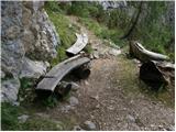 22
22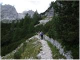 23
23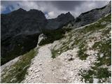 24
24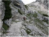 25
25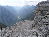 26
26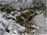 27
27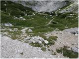 28
28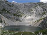 29
29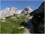 30
30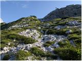 31
31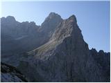 32
32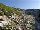 33
33 34
34 35
35 36
36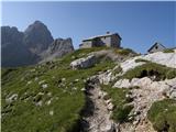 37
37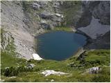 38
38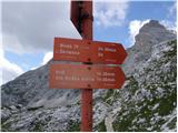 39
39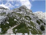 40
40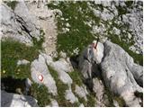 41
41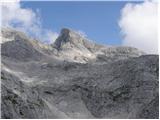 42
42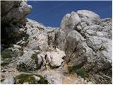 43
43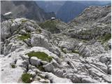 44
44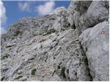 45
45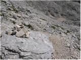 46
46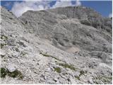 47
47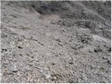 48
48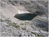 49
49
Discussion about the trail Zadnjica - The lake Zgornje Kriško jezero
|
| Guest28. 05. 2007 |
Najvišje in zame najlepše slovensko jezero. Dvojni razgled na Triglav po zraku in v vodi. Miha
|
|
|
|
| Guest17. 08. 2007 |
andreja .Najlepši in najvišje slovensko jezero. 
|
|
|
|
| Guest17. 09. 2007 |
Včeraj sem si zaželela po opisani poti, a zgornjega jezera nisem našla  Oskrbnica Pogačnikovega doma me je usmerila od modrega soda, kjer si lahko natočimo pitno vodo, na desno (levo gre markirana pot na Križ, proti jezeru pa baje ni markirano in naj bi bilo označeno samo z možici). Ker naj bi pot od tega soda potekala po ravnem in se končala v pol ure, jaz pa sem se dlje časa vseskozi dvigala mi je jasno, da sem nekje falila. Ker so bili tisti konci včeraj praktično skoz tudi v megli in nisem imela pojma kje sem, sem po 3/4h obrnila nazaj proti domu. Jezero me torej čaka ob naslednji priložnosti, če mi pomagate, kako ga najdem  Sicer pa tisti konci res lepi in jih je vsekakor vredno obiskati.
|
|
|
|
| Guest17. 09. 2007 |
Če ni megle jezera ne moreš zgrešiti. Nahaja se desno od markirane poti na križ. Predlagam krožno pot iz Vrat čez Sovatno na Pogačnikov dom in nato mimo jezera na Križ. Sestopiš pa lahko mimo bivaka na Rušju nazaj do izhodišča. Plp
|
|
|
|
| Guest17. 09. 2007 |
V kolikor gre za isto osebo,škoda da nisi želela sprejeti pomoči in jezero bi občudovala že včeraj, morda prav tako tudi kakega gamsa, kozoroga...
Jezero uzremo po kake pol ure hoje po markirani poti ki vodi od Pogačnikovega doma proti Križu, Škrlatici... potem pa samo poiščemo prehode do njega.Skratka bila si precej blizu.
lp
|
|
|
|
| Guest17. 09. 2007 |
Če bi bil človek vedež, ne bi bil revež...ali tako nekako Mogoče pa sem le bila na pravi poti, a prepočasna  no ja, pa drugič. Verjetno me je zavedel predvsem opis tu zgoraj, da hodimo po Kriških podih praktično vseskozi po ravnem, kar pa ta pot ni...no ja, sem se razpisala predvsem zato, da ne zgreši še kdo za menoj iz enakega razloga.
|
|
|
|
| Guest17. 09. 2007 |
Zgornje kriško jezero leži na nadmorski višini 2154m kar pomeni da se je potrebno od Pogačnikovega doma povzpeti dobrih 100 višinskih metrov, poleg takih opisov bi v bodoče priporočal tudi kak zemljevid.
|
|
|
|
| franjo6628. 12. 2015 |
Je kdo hodil te dni tukaj ? In kakšne so razmere. LP
|
|
|