Zadnjica - Šplevta (Razor)
Starting point: Zadnjica (650 m)
| Lat/Lon: | 46,3824°N 13,7604°E |
| |
Time of walking: 5 h 30 min
Difficulty: easy pathless terrain
Altitude difference: 1732 m
Altitude difference po putu: 1760 m
Map: Triglav 1:25.000
Recommended equipment (summer): helmet
Recommended equipment (winter): helmet, ice axe, crampons
Views: 11.552
 | 2 people like this post |
Access to the starting point:
From Kranjska Gora, drive over the Vršič pass towards Bovec or vice versa, but only as far as the 50th serpentine of the Vršiška or Ruska road (near the village of Trenta). Here you turn onto a side road, and then park for a few 100 metres in a roadside parking lot.
Path description:
From the parking lot, continue along the road, which takes you past a few houses (mainly at weekends) in about 15 minutes to a place where the road splits into two parts (there used to be a parking lot at the crossroads, but now parking is prohibited).
From the old parking lot, take the road to the left in the direction of Pogačnikov dom na Kriških podih (the road to the right leads to Prehodavci and Dolič). After 15 minutes of further walking, the road leads to the bottom station of the cargo cableway, where it ends.
The ascent continues along a marked footpath (mulatjeri) which climbs moderately through the forest. The path climbs above the valley of the White Stream and quickly leads to very steep slopes (risk of falling rocks), over which a very wide footpath leads. The path then crosses the Veliki Presek ravine, after which you reach a short exposed ledge, which you cross with the help of a rope. The path then returns to the forest, where it climbs moderately in a number of switchbacks. A little further on, the path leads us under a small overhang, where we can see a number of sticks that hikers put up to keep the rock from rolling down into the valley (the sticks are put up more as a joke than for real). The path then crosses a couple of small ravines, and then leads us past a chapel to a larger ravine. With a little care (easy) we cross the aforementioned ravine, after which we climb up to a pleasant resting place (two benches along the way) within a few minutes of further walking. Next, cross another larger ravine (in early summer, the possibility of snowfields), and then the path returns to the forest. Higher up, the forest becomes thinner and the path steeper and more scenic.
The path, which continues to climb along an old mulatier, then passes two more benches and leads to lane of dwarf pines, after which it turns into a rockier world. We continue to climb over small scree fields, along an increasingly scenic path, which leads us higher up to a pleasant little spring.
Only a few 10 steps above the spring, we will come to an unmarked crossroads, where an unmarked path branches off to the right towards Spodnje Kriško jezero (2 minutes), and we continue slightly to the left along a further wide mountain path. The path ahead leads us past small ruins, and we follow it all the way to a marked crossroads where the path from the Vrata valley joins us from the right. Continue to the left and after two minutes of further walking you will reach Pogačnik's home at Kriški podi. From home, continue past the upper station of the cargo cableway, along the marked trail, which leads us in two minutes of gentle descent to a marked crossroads, where we continue left in the direction of Razorja, Planja and Vršič (slightly right Križ and Škrlatica). Follow the path leading towards Razor and Planja for only two minutes, then leave it and continue the ascent to the right along the pathless world.
Our goal ahead is to reach the valley to the right (east) of Razor. The valley is reached by leaving the marked trail at the aforementioned part and ascending the valley on the easier, pathless ground without much difficulty. Once in the valley, you will have a nice view of the valley and the surrounding peaks (Šplevta is on the right at the back). Continue ascending the valley, which is interspersed with numerous karst potholes. Sedelce between Razor and Šplevta is now our next destination, which we will climb to in good weather without any major orientation or technical problems.
At the saddle, which offers a fine view of the Turn under Razor and the valley Cirque, we continue to the right and continue our ascent along and along the top ridge of Šplevta. Follow this relatively easy and increasingly scenic ridge "path" all the way to the summit, which is reached after a good 10 minutes of further walking.
In fine weather, orientation is relatively easy, but in fog it is almost impossible.
Zadnjica - Pogačnikov dom 4:00, Pogačnikov dom - Šplevta 1:30.

Pictures:
 1
1 2
2 3
3 4
4 5
5 6
6 7
7 8
8 9
9 10
10 11
11 12
12 13
13 14
14 15
15 16
16 17
17 18
18 19
19 20
20 21
21 22
22 23
23 24
24 25
25 26
26 27
27 28
28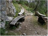 29
29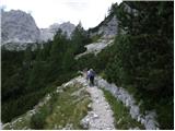 30
30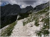 31
31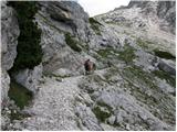 32
32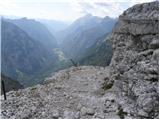 33
33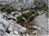 34
34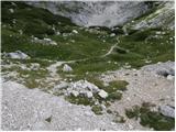 35
35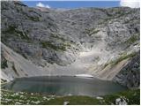 36
36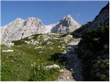 37
37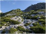 38
38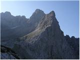 39
39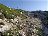 40
40 41
41 42
42 43
43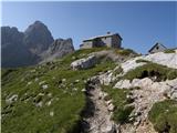 44
44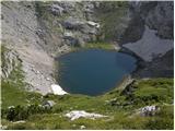 45
45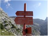 46
46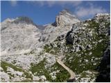 47
47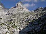 48
48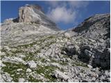 49
49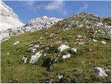 50
50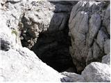 51
51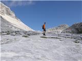 52
52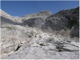 53
53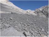 54
54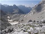 55
55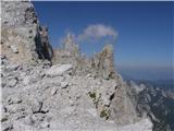 56
56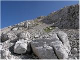 57
57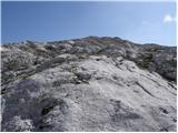 58
58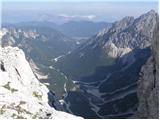 59
59 60
60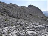 61
61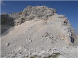 62
62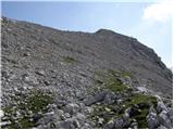 63
63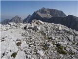 64
64
Discussion about the trail Zadnjica - Šplevta (Razor)