Zadnjica - Morbegna (via Plemenice)
Starting point: Zadnjica (650 m)
| Lat/Lon: | 46,3824°N 13,7604°E |
| |
Name of path: via Plemenice
Time of walking: 6 h 10 min
Difficulty: very difficult marked way, easy unmarked way
Altitude difference: 1870 m
Altitude difference po putu: 1870 m
Map: Triglav 1:25.000
Recommended equipment (summer): helmet, self belay set
Recommended equipment (winter): helmet, self belay set, ice axe, crampons
Views: 15.353
 | 3 people like this post |
Access to the starting point:
From Kranjska Gora, drive over the Vršič pass towards Bovec or vice versa, but only as far as the 50th serpentine of the Vršiška or Ruska road (near the village of Trenta). Here you turn onto a side road, and then park for a few 100 metres in a roadside parking lot.
Path description:
From the parking lot, continue along the road, which takes you past a few houses (mainly at weekends) in about 15 minutes to a place where the road splits into two parts (there used to be a parking lot at the crossroads, but now parking is prohibited).
Continue along the lower right road (the upper road leads to the cargo cableway leading to Pogačnikov dom) in the direction of Dolič, Luknja and Prehodavci. Initially, follow the gently sloping road, which leads us across the meadows and higher up through the forest, almost to its end, or more precisely to a marked crossroads, where a marked footpath branches off to the right towards Prehodavci (it takes about 1 hour to get here).
From the crossroads in the area called Utro, continue straight ahead and the road finally turns into a footpath or mulatier. The ascent continues along the old mulatier, which climbs moderately over occasionally steeper slopes. The climbing route over Komar soon branches off to the right, and we continue straight ahead and continue our ascent along the wide path. The scenic route, which occasionally passes over very steep slopes, leads us higher up to the next marked crossroads.
From the crossroads, turn left in the direction of Pogačnik's home, Luknja and Triglav (to the right, Koča na Doliču). From the crossroads, the military mulatto leads us eastwards and crosses steep slopes. Later, the path climbs a few times in the keys, and then crosses again in a gentle ascent up to the Luknja saddle.
At the saddle where there is a crossroads, continue right in the direction Triglava. To the left the path leads to Bovški Gamsovec, and straight down towards Aljaž's home in Vrata.
The trail becomes very difficult and starts to climb almost vertically at the beginning along the steel cable. Once over the initial wall, the route becomes slightly flatter, but this does not mean that the difficulties are over. From here on fixed safety gear is almost non-existent and occasionally we walk on the path over a deep abyss. In the wet there is a high risk of slipping! The problems then slowly ease and the path turns slightly to the left and leads us to a ridge from where we have a view to the east. Continue along the ridge and the path soon becomes slightly more difficult again. With the help of a rope and a number of pegs, you climb steeply a couple of times, followed by a short steep descent. Here, a view opens up to the left towards the famous Sphinx (the steepest pillar in the Triglav region).
The path becomes less steep and leads over scratchy terrain. The track is slightly less visible in this part, but runs to the left of Glava v Zaplanji and Morbegna, which can be seen ahead. There may be some snow on this part of the trail, even in summer, but it is not steep, so a snowshoe is not necessary.
The trail then leads us to a crossroads on the West Triglav plateau, where we continue to the right (Triglav on the left, Dolič slightly to the right) along an unmarked trail which, after a further 10-minute walk, leads us to Morbegna.

Pictures:
 1
1 2
2 3
3 4
4 5
5 6
6 7
7 8
8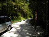 9
9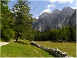 10
10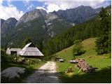 11
11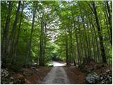 12
12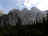 13
13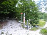 14
14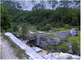 15
15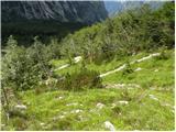 16
16 17
17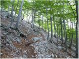 18
18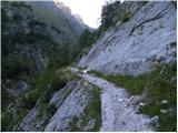 19
19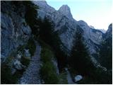 20
20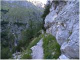 21
21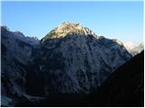 22
22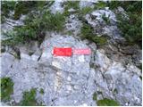 23
23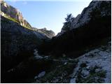 24
24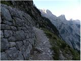 25
25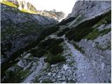 26
26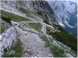 27
27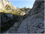 28
28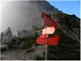 29
29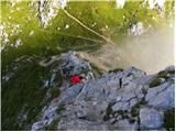 30
30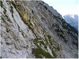 31
31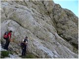 32
32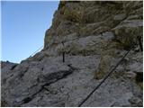 33
33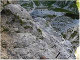 34
34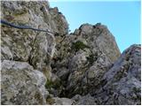 35
35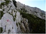 36
36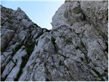 37
37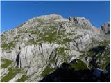 38
38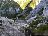 39
39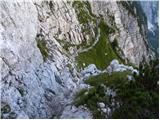 40
40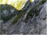 41
41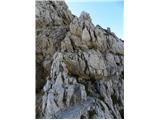 42
42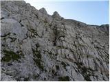 43
43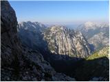 44
44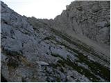 45
45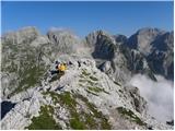 46
46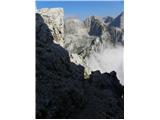 47
47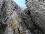 48
48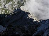 49
49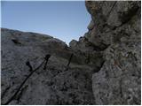 50
50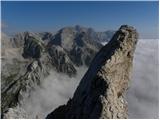 51
51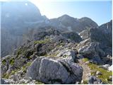 52
52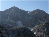 53
53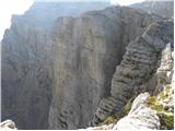 54
54 55
55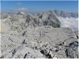 56
56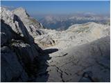 57
57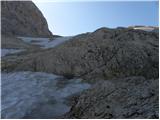 58
58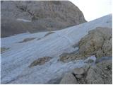 59
59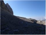 60
60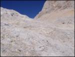 61
61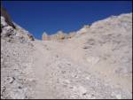 62
62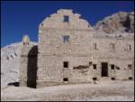 63
63
Discussion about the trail Zadnjica - Morbegna (via Plemenice)
|
| Pobesneli delfin19. 03. 2008 |
Mislim, da je povsem točno ime 'Morbegno', ne Morbegna. Kakorkoli že, imenuje se po kraju v južni Italiji.
|
|
|
|
| triglavski21. 03. 2008 |
Zgornji opis je milo rečeno slab, poln napak in kot tak nekoristen. Mulatjere seveda niso iz časa 1. svetovne vojne, ker tam pač ni bilo frontne linije, ampak iz medvojnega obdobja za časa italijanske okupacije Primorske, časovnice so čudne, nerealne, preveč raztegnjene. Sam opis poti je pomankljiv in zelo posplošen, kar ne predstavlja realne težavnosti navedene zavarovane poti, celo zavajajoč. Sfinge ne bo nihče videl, če ne ve, kje mora na rob in pogledati.
Pobeseneli delfin ima prav le glede imena, res je ime kraja "Morbegno" (naslavljamo pa jo Morbegna - kasarna Morbegna, po žensko torej), seveda pa ta kraj ne leži na jugu Italije, temveč na severuzahodu v deželi Lomabardiji, provinca Sondrio v Bormijski kotlini ob reki Addi. Lepi kraji, čeprav je že mnogo let od kar sem bil tam okoli.
|
|
|
|
| McNena16. 02. 2012 |
Bila sem poleti 2011 na tem območju, vendar če lahko rečem, je ta objekt porušen.  Seveda, če sem videla pravega, bil je skoraj ob poti s Triglava čez Škrbino proti Doliču. Prosim, če lahko kdo potrdi ta moja opažanja, ker imam občutek, da sem jo morda zgrešila, ker je na slikah tako mogočna zgradba. Hvala za odgovor. Lep pozdrav
|
|
|
|
| slainter16. 02. 2012 |
Bila sem na poti čez Plamenice na TRiglav konec septembra in mimogrede tudi pri Morbegni. Prilagam slikice, takole je zgledala, vsa porušena. lp
|
|
|
|
| IgorZlodej17. 02. 2012 |
tukaj slikc ni mogoče naložiti 
|
|
|
|
| lingo17. 02. 2012 |
Sedanje stanje je še precej slabše in sploh ne daje več vtisa velike zgradbe. Tudi zapis pod zgornjo sliko je napačen, ker leta 1918 Morbegne Italijani niso imeli še niti na papirju, to ni bil objekt iz časa prve svetovne vojne 
|
|
|