Zadnjica - Hunting cottage Na Utrci
Starting point: Zadnjica (650 m)
| Lat/Lon: | 46,3824°N 13,7604°E |
| |
Time of walking: 2 h 30 min
Difficulty: easy unmarked way
Altitude difference: 850 m
Altitude difference po putu: 850 m
Map: Triglav 1:25.000
Recommended equipment (summer): helmet
Recommended equipment (winter): helmet, ice axe, crampons
Views: 5.306
 | 1 person likes this post |
Access to the starting point:
From Kranjska Gora, drive over the Vršič pass towards Bovec or vice versa, but only as far as the 50th serpentine of the Vršiška or Ruska road (near the village of Trenta). Here you turn onto a side road, and then park for a few 100 metres in a roadside parking lot.
Path description:
From the parking lot, continue along the road, which takes you past a few houses (mainly at weekends) in about 15 minutes to a place where the road splits into two parts (there used to be a parking lot at the crossroads, but now parking is prohibited).
From the old parking lot, take the road to the left in the direction of Pogačnikov dom na Kriških podih (the road to the right leads to Prehodavci and Dolič). After 15 minutes of further walking, the road leads to the bottom station of the cargo cableway, where it ends.
The ascent continues along a marked footpath (mulatjeri) which climbs moderately through the forest. The path climbs above the valley of the White Stream and quickly leads to very steep slopes (risk of falling rocks), over which a very wide footpath leads. The path then crosses the Veliki Presek ravine, after which you reach a short exposed ledge, which you cross with the help of a rope. The path then returns to the forest, where it climbs moderately in a number of switchbacks. A little further on, the path leads us under a small overhang, where we can see a number of sticks that hikers put up to keep the rock from rolling down into the valley (the sticks are put up more as a joke than for real). The path then crosses a couple of small ravines, and then leads us past a chapel to a larger ravine. With a little care (easy) we cross the aforementioned ravine, after which we climb up to a pleasant resting place (two benches along the way) within a few minutes of further walking. Next, cross another larger ravine (in early summer, the possibility of snowfields), and then the path returns to the forest. Higher up, the forest becomes thinner and the path steeper and more scenic.
At a height of about 1500 m, at the point where the marked trail turns right, you will notice an unmarked path at a slightly larger rock, which turns left and leads to a hunting lodge after a minute's walk.

Pictures:
 1
1 2
2 3
3 4
4 5
5 6
6 7
7 8
8 9
9 10
10 11
11 12
12 13
13 14
14 15
15 16
16 17
17 18
18 19
19 20
20 21
21 22
22 23
23 24
24 25
25 26
26 27
27 28
28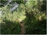 29
29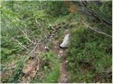 30
30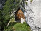 31
31
Discussion about the trail Zadnjica - Hunting cottage Na Utrci
|
| spotonbody26. 05. 2010 |
lep pozdrav, zanima me, kam pa pelje naprej markirana pot, če nadaljujemo desno, namesto da zavijemo levo proti lovski koči?
hvala.
|
|
|
|
| spotonbody26. 05. 2010 |
aha, super, hvala! Ali mogoče veste, kakšne so trenutne razmere na Kriških podih in okoliških gorah..predvsem koliko je še snega in koliko so poti kaj shojene in varne?
|
|
|
|
| Tadej26. 05. 2010 |
Trenutno je v visokogorju še več kot 2 m snega. Na Kredarici ga je bilo danes zjutraj še 290 cm. Za poti, katere sprašuješ so slabo uhojene. Za vzpone na omenjene vrhove so obvezni cepin, dereze ter ponekod tudi čelada.
|
|
|