Vas na Skali - Veliko Špičje (on ridge of Špičje and on route Tumova smer)
Starting point: Vas na Skali (980 m)
| Lat/Lon: | 46,3404°N 13,7097°E |
| |
Name of path: on ridge of Špičje and on route Tumova smer
Time of walking: 5 h
Difficulty: very difficult pathless terrain
Altitude difference: 1418 m
Altitude difference po putu: 1420 m
Map: Julijske alpe, Trenta, Triglav
Recommended equipment (summer): helmet
Recommended equipment (winter): helmet, ice axe, crampons
Views: 6.882
 | 5 people like this post |
Access to the starting point:
From the village Soča drive towards Log and after a kilometre turn right over the bridge into the Vrsnik valley. Just after the bridge turn right again and then after half a kilometre turn right again. Keep to the asphalt road, passing the end of the Pod Zjabci valley and also the hamlet of Vas na Skala, until you reach a fork at 980 m, where the main road turns left and straight ahead the forest road is blocked by a ramp. Park here.
Path description:
From the ramp, follow the road to the right for approx. 800 m (also cross the stream to the slope below the Travnik edge), when you see cairn made of stones in the grass on the left, and a small path through the grass into the forest. Further into the forest the track is clearly visible. It leads us first through a dense spruce forest, where passage is more or less only possible along a path. Further on, the forest thins out and we cross the forest road (1230 m), which we left earlier, and continue above the road in a similar direction, i. e. in the direction of the Špičje ridge to the NE. Soon after leaving the forest we reach dwarf pines in a narrow valley, at the end of which we cross a torrent slightly left into the forest, in which there is one small cairn. The path leads to a small shoulder from which turn left onto a forest road. If you get lost in this little forest, stick to the direction of the valley (the place is called Dol pod Plazmi), which leads to a meadow from which you can easily reach the aforementioned forest road. Follow the latter for about 300 m, when you reach a crossroads with a small pillar marking the local footpath. It is most convenient for us to follow the forest road straight to Dolo. After approx. 200 m the road ends at a forest clearing. At the end of the clearing (keep to the left edge), cross the torrent and immediately on the other side you will catch the path that leads through the low forest to Dol - i. e. the huge plain below the walls of the Labrji Peak (on the right) and the Plazijanske Vršacev (on the left). At the end of the plain, follow the torrent, where there is water for most of the year, until you reach a higher scree slope, where you stick to the left edge to the boulder at 1750 m. Here you can follow the grasses on the left to join the variant from Dol pod Plazmi over the Čez Drt pass and the ridge path over Plazijanske Vršace. Alternatively, continue along the scree to 1940 m (almost to the wall), crossing the steep grass to the grassy ridge on the left (20 m). If you have already turned left before, to get here you must first pass through dwarf pines (along the ridge), then from the first saddle to the right almost to the scree, then steeply up and left back to the ridge, to the S side, then up the steep scree through a faintly visible gully above and finally to the ridge mentioned above. Here a passage opens to the left to a grassy shoulder on the left. On the shoulder, turn back towards the wall and follow the ridge to the wall (or walk along the slope on the SW side) until you reach a broken gully. Follow it up to a 2 metre black slab, which is bypassed on the right slope. Follow the gully higher up for a few metres, then turn right up the slope, recognisable by the steep grasses and white crumbly rubble. Higher up, the rock becomes more compact. After 20 m, cross a shelf to the left to reach the summit gully and along its left side reach the main ridge of Špičje (marked path). The Veliko Špičje summit is 15 m away on our right.

Pictures:
 1
1 2
2 3
3 4
4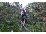 5
5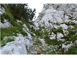 6
6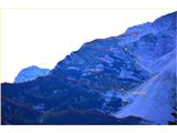 7
7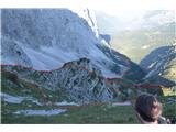 8
8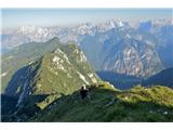 9
9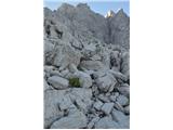 10
10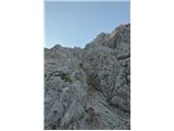 11
11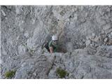 12
12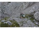 13
13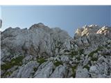 14
14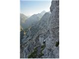 15
15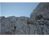 16
16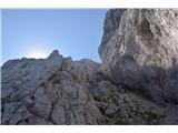 17
17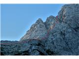 18
18
Discussion about the trail Vas na Skali - Veliko Špičje (on ridge of Špičje and on route Tumova smer)
|
| ljubitelj gora19. 08. 2015 |
To smer vzpona že gledal s Čistega vrha, samo mal dvomim, da je samo zahtevno brezpotje, kakšna je ocena za plezanje.
|
|
|
|
| janezs7320. 08. 2015 |
Pozdrav vsem,
že urednik teh spletnih strani me je opozoril na morebitno težavo pri (p)o(d)cenjevanju smeri.
A moja argumentacija je preprosta. Če se držiš najbolj logične smeri, pravzaprav nikjer zares ne plezaš. Nikjer ni npr. takega mesta, kot je plošča pod vrhom Oltarja z Grla, ki je ocenjena z II. V vseh opisih Tumove je omenjena plošča z oceno III, ki naj bi bila v prvi grapi (na mestu, ki ga kaže slika 12). Jaz te plošče nikjer nisem našel, kaj šele , da bi bilo kje potrebno plezati v tej grapi, ki je sicer zelo zagruščena, ne pa preveč strma. Prekinitev grape v zgornjem delu se da z enim samim potegom obiti kak meter nižje. v prečenju iz prve v zgornjo grapo so prehodi enostavni.
Glede dostopov, najtežje je sploh priti na travnato ramo, iz katere se doseže prvo grapo; midva sva šla - jaz po grebenu prek Grive, kolega pa sem usmerjal za sabo po lažjih prehodih, ki so od zgoraj ponavadi lepše vidni kot od spodaj. Zato sem vse variante vrisal na slike. Upam, da bodo v pomoč.
Prehod iz prevala Čez Drt do Grive je manj ugoden, saj je preveč spustov vmes, smer po dolini (Dol je omenjen v opisu), kot sva jo ubrala s kolegom pa trivialna.
pa varne vzpone vsem. lp janez
|
|
|