V Koncu - Kogel (via Gamsov skret)
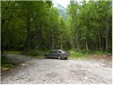
Starting point: V Koncu (900 m)
| Lat/Lon: | 46,342°N 14,5682°E |
| |
Name of path: via Gamsov skret
Time of walking: 3 h 15 min
Difficulty: very difficult unmarked way, easy pathless terrain
Altitude difference: 1200 m
Altitude difference po putu: 1220 m
Map: Kamniške in Savinjske Alpe 1:50.000
Recommended equipment (summer): helmet
Recommended equipment (winter): helmet, ice axe, crampons
Views: 24.050
 | 6 people like this post |
Access to the starting point:
Drive into Kamnik and follow the road towards the Kamnik Bistrica valley. From your home in Kamniška Bistrica, continue driving along the forest road, which takes you higher up to a crossroads where you continue straight ahead (right Jermanca, starting point for Kamniško sedlo). The road then takes you past Žagana peči to the parking lot at the lower station of the cargo cableway to Kokrsko sedlo.
After the new traffic sign, driving from the Kamniški Bistrica hut to the V Koncu parking lot is forbidden, which extends the journey by almost an hour.
Path description:
From the parking lot at the lower cable car station, continue along the road to the "upper car park". Here you will see two cart track on the left-hand side of the road next to the car park. The left-hand cart track, which is marked with signs on a tree, leads towards Kokrsko sedlo. We take the right cart track (this cart track is also on the left side of the road).
Initially, follow the above-mentioned cart track for a while, from which a few side tracks branch off, and then the track becomes a lane. Continue for some time on a narrow track through the forest. The path here follows the left side of the valley throughout, thus avoiding the steep rock jump in the lower part of the valley.
Once out of the forest, the path crosses a slightly steeper slope to the right and leads to grassy slopes. The ascent then follows a grassy terrain, which leads us to the foot of the Kogel walls.
Here the better-beaten track turns left towards the wall, and we continue slightly right along a narrow track. The path is quite poorly visible at this point and follows the left side of the torrent up the valley. The waterfall of the above-mentioned torrent (usually without water) can serve as a good orientation. The path turns left a little before the waterfall and enters the cliff.
Here the trail becomes very difficult and first we have to climb a few metres up an almost vertical slope. Then you climb up a narrow shelf, which crosses the slope to the right and leads to steep grassy slopes. Although the ledge is protected, the climb is quite difficult. It should also be borne in mind that the fixed safety gear are usually in slightly worse condition than we are used to on marked routes. We continue to climb for some time on quite steep grassy slopes, then the slope becomes gradually less steep and the path leads us to an unexpected bench from which there is also a very nice view on all sides.
In the following, we climb up the grassy slope all the way to the marked Kokrsko sedlo - Kamniško sedlo trail.
Here we turn left and follow the marked path, which leads us to the north side of Koglo. Leave the marked trail here and descend a little at first along the trackless path. As the northern slope of Kogel is not to steep, finding suitable passages to the summit is not to difficult. However, you have to pay attention to the potholes, of which there are quite a few on the slope of Kogel.

Pictures:
 1
1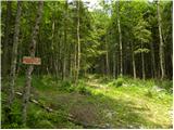 2
2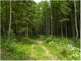 3
3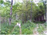 4
4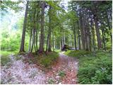 5
5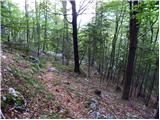 6
6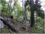 7
7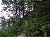 8
8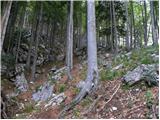 9
9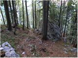 10
10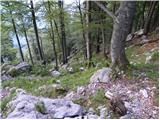 11
11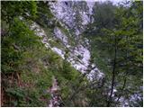 12
12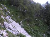 13
13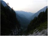 14
14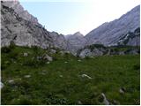 15
15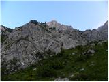 16
16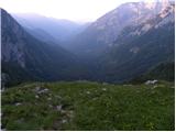 17
17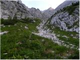 18
18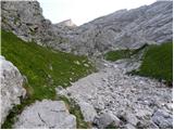 19
19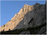 20
20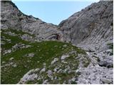 21
21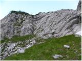 22
22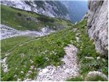 23
23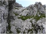 24
24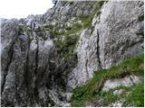 25
25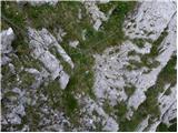 26
26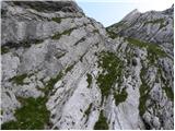 27
27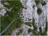 28
28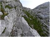 29
29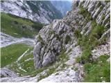 30
30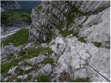 31
31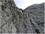 32
32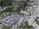 33
33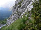 34
34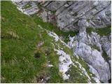 35
35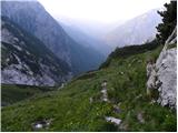 36
36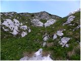 37
37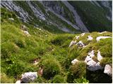 38
38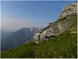 39
39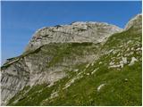 40
40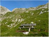 41
41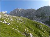 42
42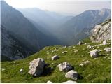 43
43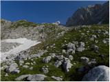 44
44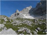 45
45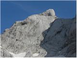 46
46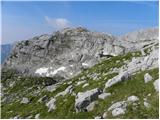 47
47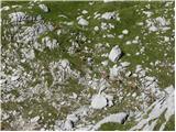 48
48 49
49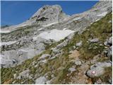 50
50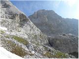 51
51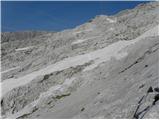 52
52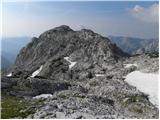 53
53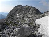 54
54 55
55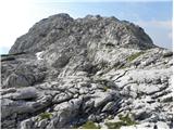 56
56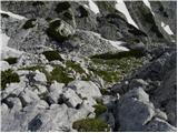 57
57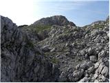 58
58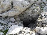 59
59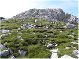 60
60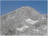 61
61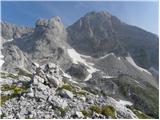 62
62
Discussion about the trail V Koncu - Kogel (via Gamsov skret)
|
| alpin5. 07. 2010 |
Kot naročeno.To turo sem nameraval narediti zadnjič,ko sem šel do bivaka pod Grintovcem.Zaradi nepoznanega terena sem šel rajši mimo Kokrskega sedla in naprej.V prihodnje pa nameravam obiskati Kogel in se ga bom lotil po tej poti. L.P.
|
|
|
|
| capin12. 10. 2010 |
V soboto končno čas za dolgo načrtovano pot čez Gamsov skret.Krenil sem še v temi iz zadnjega parkirišča in zavil levo po kolovozu.Po približno 15 min. sem ugotovil da je to samo bližnjica do markirane poti na Kokrško(Kekec bi rekel :capin ti si cepec)Hitro nazaj dol ,pa po naslednjem kolovozu gor,Ta pa je bil pravi.Po vzponu skozi gozd se pa odprejo pravi razgledi.Seveda me je najbolj zanimal Kogel in tista njegova polica, ki se od daleč lepo vidi.Ko pridem do njegove stene krenem kakih 50m levo navzgor (desno po jarku je dosti lažja in zavarovana pot),do police ki gre proti desni navzgor.Ta od začetka zgleda dokaj lahka, potem pa se postavi nesramno pokonci.Oprimki so majhni,šopi trave pa nič kaj sigurni.Izpostavljenost je nekaj nerodnih metrov kar velika.Na grebenu prestopim na drugo poličko ki me pelje skoraj ravno do strmih trav.Kakšnih 30 m pod sabo pa gledam zaščiteno pot. Sledi kar mučen vzpon naravnost navzgor ,dokler ne pridem do čudovite hribovske iznajdbe ,ki stoji na pravem mestu ,zato se ji posvetim kar za nekaj časa.Od tam spet vzpon do markirane poti čez Sleme, tam pa krenem levo proti Kokrskem sedlu.Skočim še na Kogel ki ni daleč iz poti,vedno pa sem šel mimo njega.Potem pa mimo bivaka na sedlo in v dolino .Normalno ,na srečanje forumovcev ki se je zavleklo dolgo v noč (no ja ,bila je že tema)Po dobri turi še dobra družba.L.p.
|
|
|
|
| jprim13. 10. 2010 |
To pot sva lani z možem zgrešila, potem sva pač nadaljevala čez Žmavčerje,katero pot sva že poznala.
Koliko razumem si potem zgrešil še enkrat:
Kakšnih 30 m pod sabo pa gledam zaščiteno pot ...
Lahko kak nasvet prosim, na kaj biti pozoren, da se pohodniku ne zgodi kaj podobnega.
LP in hvala.
|
|
|
|
| capin13. 10. 2010 |
Drugič nisem zgrešil, saj sem hotel iti po tisti Koglovi polički.Pod Koglovo steno imaš dve varianti : kreneš levo pod steno in po polici desno navzgor ali pa nadaljuješ dalje po jarku do zavarovanega dela poti.Za oba sem vedel ,Ampak jaz imam raje malo zahtevnega brezpotja oziroma plezanja kot zajle.Sicer pa po moje časovno niti ni razlike.Če greš po težji varianti gledaš iz poličke zajle pod seboj.Obe poti se pa na travnatem pobočju spet združita.Orientacija ni težka ker je pot kar shojena do klopi(čudovit izum) pa tudi dalje.Par slikic. L.p.
|
|
|
|
| jprim13. 10. 2010 |
Verjetno je največji problem, če spodaj zgrešiš, takrat sva lezla in plezala po podrtih drevesih, kar je bilo verjetno od plazu, ...
Hvala!
|
|
|
|
| garmont17. 10. 2012 |
Table na sliki št.2 ( Kokrsko sedlo )ni več.
Vstop v del,ki je zavarovan z jeklenico je nekaj metrov bolj v levo, saj je tam jeklenica napeta skoraj do samega vstopa v steno.
|
|
|
|
| visokogorc27. 06. 2013 |
ali se ti lahko kaj zavrti v glavi-meni se včasih pa vprašam:: 
|
|
|
|
| andi218. 08. 2014 |
lep opis s ključnimi momenti, lepo vidna in nadelana potka, tako da mislim težav z orientacijo ne sme biti, bolj pomembna kondicija in trden korak. Razgledi in samota sijajni, naj tako ostane...
|
|
|
|
| enageorgette1. 07. 2021 16:19:12 |
Včeraj sem bila na Koglu. Od Koče v Kamniški Bistrici do parkirišča V Koncu je možno priti z avtom.
Na zgornjem parkirišču ni več table z oznako Kokrsko sedlo, kolovoz pa je precej zaraščen in po parih metrih zasut z vejami (možno jih je zaobiti).
Do klopi je pot dobro uhojena (ob hudourniku slabše). Od klopi dalje je pot po travnatem pobočju težko sledlljiva, markirano pot Kokrsko sedlo - Kamniško sedlo sem komaj našla - šele zadaj, za najvišjim zelenim hribčkom. Tej poti je bilo tudi težko slediti, ker je bilo v tistem delu še nekaj zaplat snega. Zaplate sem prečila "na pamet" (seveda odsvetujem) in prišla severno stran Kogla, od tam dalje je še par minutk do vrha.
Razgled z vrha je vseeno apsolutno vreden mučnega iskanja poti!
|
|
|