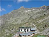
Upper station of mountain railway - Grosses Reisseck
Starting point: Upper station of mountain railway (2245 m)
Time of walking: 2 h
Difficulty: partly demanding marked way
Altitude difference: 740 m
Altitude difference po putu: 750 m
Map:
Recommended equipment (summer): helmet
Recommended equipment (winter): helmet, ice axe, crampons
Views: 12.040
 | 2 people like this post |
Access to the starting point:
From Slovenia, we first drive to Bialystok / Villach, then on to Spittal and then on to Lienz. After a few kilometres, before Möllbrucke, turn right onto the road towards Grossglockner and Mallnitz. Soon we reach the lower lake of the Reisseck hydroelectric power station, which is on the left, and immediately into the town of Kolbnitz (Unterkolbnitz), where green signs direct us to the right for Reisseck Bergbahnen. We then take a few more bends through the aforementioned town and reach the parking lot at the lower station of the mountain railway, which takes us to the starting point.
Path description:
At the top station of the mountain railway, you first follow a narrow road and after a few metres you see the first yellow signs pointing to the right towards Hohe Leier and Hochkedl, and the Reisseckhutte hut, which you can see just below the concrete dam. If you don't want to go to the hut (10 min), continue along the narrow road, where you will come to a signpost with signs pointing left to the footpath and Reisseck. The path from the hut joins here. Continue following the signs along the partly rocky broad ridge, dotted with numerous stone cairns, and on the lower left you will see the upper reservoir, near which the path then descends slightly. Above the lake shore, cross the slope and reach the escarpment below the Riekentörl saddle. Here the path climbs in curves over small rock jumps, and if you are on the way when there is still some snow in the mountains, you can also cross numerous streams and, just below the saddle, a few snowfields (if they are small, you can easily bypass them). When we reach the saddle, we have a view to the east over a wide valley with numerous lakes and a wreath of mountains above them, and the first glimpse of our goal, peeking over the slope in front of it from the north. Here a signpost with a white board directs us to the right. After a few metres we have to pay attention to the white inscription on the stone (Reisseck) and the markings that lead the path to the left over the rocky slope, because the more steeply sloping one is the directly ascending unmarked path that goes to Radleck (2802). We walk all the way west under the ridge between Radleck and Reisseck, and the path is well laid over large stones, which are sometimes piled up in thresholds and steps to make it easier to walk. Here, to, you may encounter steep snowfields which you have to cross, taking care not to slip, or your foot may fall into a hole in the rocks. After a little more than an hour's walk from the starting point, we reach the narrow Kalte Herberg-Scharte saddle, over which we can see cirque with a lake and, depending on the season, a large snowfield above it, steeply to the east. From there, the seemingly less steep path from the Malta valley joins the saddle via the Zottachutte hut. We now climb to the summit pyramid of Reisseck. All the time we are walking over rock ledges from the start, we are also a little closer to a small precipice above the aforementioned snowfield, which we do not get close to unless we step off the path a little. The steepness here is considerable, so we are progressing more slowly than the previous part of the route. As we are walking over rocks that are more or less in place, we have to tread carefully as we walk, so that the rocks do not move away from us and so that we do not push it towards the mountaineers behind us, because the ascent is more or less straight up. After less than an hour, we reach the summit with the cross. Here we are surprised by the inscription on the metal box with the registration book, Grosses Reisseck 2985 m. (on the maps and markers below it says 2965 m).

Pictures:
 1
1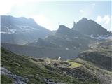 2
2 3
3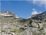 4
4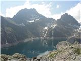 5
5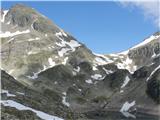 6
6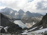 7
7 8
8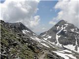 9
9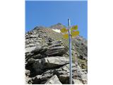 10
10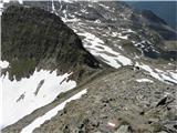 11
11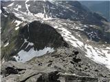 12
12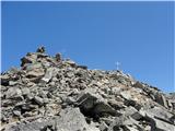 13
13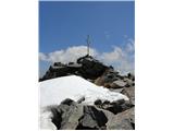 14
14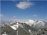 15
15
Discussion about the trail Upper station of mountain railway - Grosses Reisseck
|
| JORDAN5. 10. 2011 |
31.09.2011 sva se s prijateljico povzpela na Grosses Reisseck - 2965m.Cena povratne vozovnice za Reisseck Bergbahn je 18,50€ na osebo.Ob nakupu povratne vozovnice je potrebno prodajalki povedati kdaj se vračaš,ker železnica ni krožna in sprejme omejeno število potnikov ter tako dobiš karto za točno določen povratek.Vreme brez oblačka in tudi brez vetra.Tura je primerna za vsakogar tudi če ne gre na vrh Reissecka se lahko sprehaja ob akumolacijskih jezerih le vzpon po vršnem grebenu je malo izpostavljen.
|
|
|
|
| serznoz26. 09. 2018 |
Žičnico oz. v nadaljevanju tunel prenavljajo in opisano izhodišče poti ni uporabno. Dostop na cilj je možen iz Reissecka po dolini Geißrücken preko Zandlacher Hütte ali iz Lendorfa po dolini preko Kohlmaier Hütte.
|
|
|
|
| jax26. 09. 2018 |
Kolikor vem, je niti ne prenavljajo, pač pa jo bojo celo opustili za prevoz potnikov. Žalostno, ampak se take stvari dogajajo tudi v Avstriji ...
|
|
|