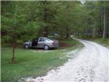
Starting point: The Krma Valley (930 m)
| Lat/Lon: | 46,3851°N 13,9071°E |
| |
Time of walking: 2 h 45 min
Difficulty: difficult marked way
Altitude difference: 1078 m
Altitude difference po putu: 1078 m
Map: TNP 1:50.000
Recommended equipment (summer): helmet
Recommended equipment (winter): helmet, ice axe, crampons
Views: 13.027
 | 2 people like this post |
Access to the starting point:
a) Leave the Gorenjska motorway at the Hrušica exit and follow the road towards Kranjska Gora. Just before the village of Dovje, the road branches off to the left and leads to Mojstrana (Vrata, Kot and Krma). Follow the road in the direction of the village of Radovna and the valleys of Krma and Kot. The relatively steep road then takes you past a TNP signboard, after which the road soon becomes a dirt road and leads you to a junction where the dirt road to the valley of Kot branches off to the right. Continue straight ahead on the road, which begins to descend. In the middle of the descent, the road to the Krma valley branches off to the right (straight ahead Radovna). A little further on, you come to the next crossroads, where you continue to the right in the direction of Krma. The macadam road then leads to Kovinarska hut, and we follow it further. Occasionally, a slightly worse road then leads us to the parking lot in front of the gate.
b) Take the Kranjska Gora, then continue driving in the direction of Jesenice. Leave the main road at Dovje and turn right towards Mojstrana and the valleys of Vrata, Kot and Krma, following the signs for Krma at the next junctions. The relatively steep road then leads us past a TNP signboard, after which the road soon lays down and leads us to a crossroads where a macadam road branches off to the right into the Kot valley. Continue straight ahead on the road, which begins to descend. In the middle of the descent, the road to the Krma valley branches off to the right (straight ahead Radovna). A little further on, you come to the next crossroads, where you continue to the right in the direction of Krma. The macadam road then leads to Kovinarska hut, and we follow it further. Occasionally, a slightly worse road then leads us to the parking area in front of the barrier.
Path description:
Just 50m before the parking lot, a marked trail to Lipanca branches off to the left. Take this path, which after an initial three-minute walk begins to climb steeply. After a few minutes of walking, the path leads us under the cliffs where we notice a sign that the path we are going to climb was built in 1952.
The path then climbs steeply through the forest to a slightly more difficult crossing, where we are helped by wedges, less steep steps and a steel cable (not difficult). The path then leads us between dwarf pines and we continue to follow it to a mighty torrential ravine. The ravine is reached by a slight descent at first, and on the other side by a steep slope. Crossing the ravine is difficult or even impossible after heavi rainfall, but as the slopes are steep the water drains away quickly. The path then climbs through the forest, still steeply upwards. The path, however, gets closer and closer to the steep slopes and rocky cliffs. As the forest becomes much thinner, the path climbs steeper still. For a short time the path becomes so steep that you have to help yourself a little with your hands. This part is a slip hazard in wet conditions, but in dry conditions it is not a major hazard. The path then leads under steep rocky cliffs where, especially in spring, there is a high risk of falling rocks. The crossing under the cliffs is almost horizontal, and then the path climbs again. Again, we are helped by a small (easy) steel cable, which leads to grassy slopes. Next, we cross the slopes again, exposed to falling rocks, and soon afterwards we reach a less steep part of the path. We continue climbing along the increasingly scenic path mostly between dwarf pines and sparse forest to a crossroads, where we turn left in the direction of Debela peč The way ahead leads us in a moderate ascent in a few minutes to Lipanska vrata, from which we descend in a few steps to a crossroads.
Continue left in the direction Brdo - Debela peč along the path surrounded by dwarf pines almost horizontally. After a few minutes, a marked, but initially slightly less visible path branches off to the left up to the top of Brda (Brdo). After a short climb, the path leads to a ridge, where the path turns right and leads us to the top in a few dozen steps on an easy slope.

Pictures:
 1
1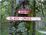 2
2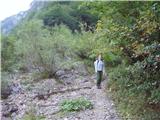 3
3 4
4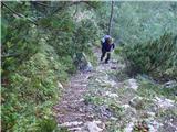 5
5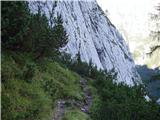 6
6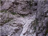 7
7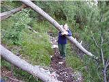 8
8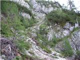 9
9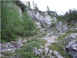 10
10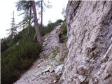 11
11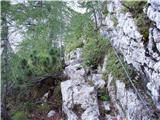 12
12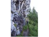 13
13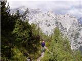 14
14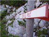 15
15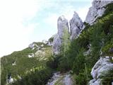 16
16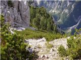 17
17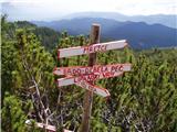 18
18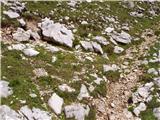 19
19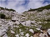 20
20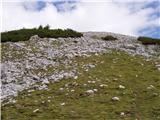 21
21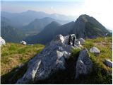 22
22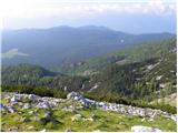 23
23
Discussion about the trail The Krma Valley - Brda
|
| Ajda_Zitnik8. 07. 2012 |
Pot sem prehodila danes. Dodala bi samo, da bi neizkušenim planincem odsvetovala to pot - še posebej, če se boste vračali po njej. Pot je strma v pravem pomenu besede in včasih navzdol to lahko povzroča enake probleme kot za navzgor.
Nadalje bi samo še opozorila, da je čas mogoče malo strogo odmerjen. Če pogledate na pzs.si, lahko pri kovinarski koči opazite, da je za Debelo peč potrebnih 4 ure hoje. Iz Brd pa do Debele peči pa verjamite mi ne potrebuješ 1 ure in 15 minut, ampak mogoče 30 do 45 minut. Sama bi napisala, da je hoje za 3 ure 15 do 3 ure 30 min.
|
|
|
|
| Ajda_Zitnik8. 07. 2012 |
Aja pa še to, višinska razlika po poti je po moji oceni vsaj 1100 m, ker se nekajkrat kar lepo spustiš po 5 in 10 m dol in jih moraš nato nadoknadit.
|
|
|
|
| KarmenT31. 08. 2019 |
Danes prvič po tej poti. Pot dobro shojena, a zelo strma, z izjemo začetnih nekaj minut in zadnjega dela. V veliko pomoč "skalnati" oprimki in rušje. Nekaj minut od izhodišča levo v grapi šumi potoček, a do njega ne pelje nobena pot. Vrhovi nad dolino Krme osupljivo lepi, pobočja zelo strma. Triglav in Rjavina ves čas pokrita z oblaki. Lipanska vrata mogočna. Na poti nisva srečala nikogar, sicer parkirišče v Krmi polno. Na vrhu vetrovno, tudi nekaj sončka sva dočakala. Zanimiva pot 
|
|
|
|
| Majdag1. 09. 2019 |
KarmenT, po opisu so Lipanska vrata pri smerokazih, na grebenu.. Mogoče pa kdo ve?
|
|
|