Podolševa (Rogar) - Govca (Olševa) (direct way)
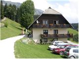
Starting point: Podolševa (Rogar) (1240 m)
| Lat/Lon: | 46,4355°N 14,6595°E |
| |
Name of path: direct way
Time of walking: 2 h 10 min
Difficulty: difficult marked way
Altitude difference: 689 m
Altitude difference po putu: 720 m
Map: Kamniške in Savinjske Alpe 1:50.000
Recommended equipment (summer):
Recommended equipment (winter): ice axe, crampons
Views: 111.006
 | 5 people like this post |
Access to the starting point:
a) Drive to Luce (to get here from Mozirje or from Kamnik via the Volovljek (Kranjski Rak) pass), then continue driving towards the Logar valley. In the village Solčava, leave the main road towards the Logar valley and turn right towards Podolševa, the Spodnje Sleme pass and Črna na Koroškem. The road then loses its asphalt surface, and after a few kilometres we turn left at the junction in Podolševa towards the panoramic road (to the right the Spodnje Sleme pass and Črna na Koroškem). We continue towards the Church of the Holy Spirit, and we park a few 100 metres before the church in a convenient place on the roadside near the Rogar farm.
b) We drive to Črna na Koroškem (to get here from Ravne na Koroškem or from Šoštanj via the Spodnje Sleme pass), and then continue driving towards Luce. Initially still an asphalt road, higher up it becomes a macadam road and leads to a crossroads of several roads at the Spodnje Sleme Pass. From the pass, continue towards Solčava, then turn right towards the panoramic road (on the left road you will arrive in Solčava), then continue towards the Church of the Holy Spirit, and we park a few 100 m before the church in a suitable place on the roadside near the Rogar farm.
Path description:
From the starting point, first walk to the Rogar Tourist Farm, and from there continue left along cart track, which begins to climb through the forest. A little higher up, the cart track joins us from the left, coming from the Church of the Holy Spirit, and we continue to the right along the marked path leading towards Olševa. Cart track then turns into a path which quickly leads to the state border. Continue climbing along the state border for some time, then arrive at a marked crossroads, where you turn right in the route Potočka zijalka (left Remschenik / Remschenig).
From the crossroads, there is a steep climb for about 10 minutes and you are at the karst cave called Potočka zijalka.
From Potočka zijalka, continue along the marked path in the direction of Govce and start climbing steeply again. A little further on, we reach the next crossroads, where the path to Obel kamen (1911 m) branches off to the left, and we continue to the right in the direction of Govca (Govca is the highest peak of Olševa). Then we cross the steep slopes of Olševa, and in the more exposed parts, we are helped by some rope ladders. The path then turns to the left and we join the path that leads over the top of Obel kamna. Here we continue to the right and start to climb steeply up the increasingly scenic slope. Higher up, the path bends and leads along a ridge, which quickly leads to the highest peak, Govca.

Pictures:
 1
1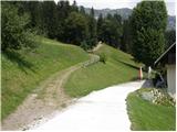 2
2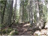 3
3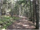 4
4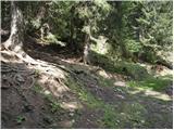 5
5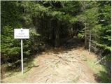 6
6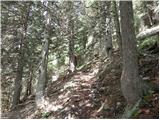 7
7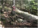 8
8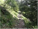 9
9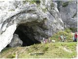 10
10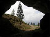 11
11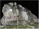 12
12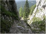 13
13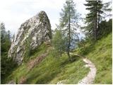 14
14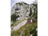 15
15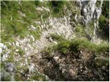 16
16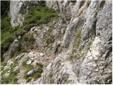 17
17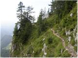 18
18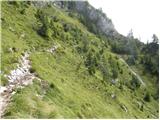 19
19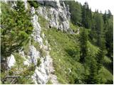 20
20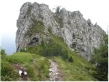 21
21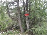 22
22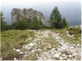 23
23 24
24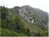 25
25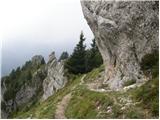 26
26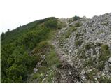 27
27 28
28
Discussion about the trail Podolševa (Rogar) - Govca (Olševa) (direct way)
Show older messages
|
| Guest22. 08. 2007 |
Priporočam, da greste najprej na Obel kamen in potem od tu po vrhnem delu na Govco. Tu je sicer nekoliko težja pot, vendar pa je razgled prelep. Tudi časovno ni dosti daljša.
|
|
|
|
| Guest22. 08. 2007 |
Za Gorenjce pa je najboljši in najkrajši dostop tale:
Zapeljete se na Jezersko, preko mejnega prehoda Jezerski vrh, mimo Bele (Bad Vellach) do odcepa na Pavličevo sedlo, čez Pavličevo sedlo mimo Majerholda in nato na levo cesto ki pelje v Podolševo.
|
|
|
|
| legenda11. 07. 2009 |
Se strinjam.Dostop do izhodišča v Podolševi je preko Pavličevega sedla za gorenjce res najkrajši,zame pa tudi lepši kot iz Logarske doline.Prilagam nekaj utrinkov,posnetih lani jeseni,ko sem se potepal po teh krajih.
|
|
|
|
| Pogačica19. 07. 2009 |
Lepo prosim za informacijo, kaj pomeni (kot piše Gost zgoraj) da je pot čez Obel kamen "nekoliko težja, časovno pa ne dosti daljša". Jutri se odpravljamo na Govco po zgoraj opisani poti, vendar ker bomo z otroci me vseeno zanima, koliko je pot čez Obel kamen daljša in ali je izpostavljena. Kakšna fotka s tega dela poti bi bila več kot dobrodošla. Hvala.
|
|
|
|
| geppo19. 07. 2009 |
Z otroki je mogoče res bolje če se odločiš za razpotje in greš DESNO in ne na Obel kamen. Je pa res,da je lepša ( RAZGLEDNEJŠA ) po grebenu. Sami ocenite kako so kaj otroci vajeni hoje v gorah. Tam je pač en odsek, ki je za nekoga malo težavnejši za nekoga pa ne!!
Fotografij na žalost nimam!
Lp
|
|
|
|
| Pogačica20. 07. 2009 |
Hvala geppo, smo se res rajši odločili, da tokrat izpustimo Obel kamen, ampak tudi brez tega smo uživali v razgledih  . Prekrasen izlet!
|
|
|
|
| Kozorog21. 07. 2009 |
Danes je bil res čudovit dan... pot na Obel kamen sem zgrešil... razgled je pa tako ali tako daleč najlepši na "Slovensko" stran tako da smo tu izjemno uživali...
|
|
|
|
| petruša19. 05. 2010 |
Zanima me kakšne so kaj razmere na Olševo, še je kaj snega?. lp
|
|
|
|
| geppo19. 05. 2010 |
Petruša, tukaj znajo biti pa razmere ugodne!
Lp
|
|
|
|
| petruša19. 05. 2010 |
Misliš, da na poti ni več snega, ker bi šli z otroci, enkrat smo že bili na Olševi samo v mesecu juniju.lp
|
|
|
|
| geppo19. 05. 2010 |
Petruša, mislim da ne bi smelo biti nobenih posebnih težav. Odsvetujem ti pa iz Robanovega kota!
Lp
|
|
|
|
| damijan6614. 09. 2010 |
Zanima me, če gresta dve vzporedni poti z Obel kamna proti Govci. Mi smo od lesenega križa hodili po poti, široki le za stopalo, ki je prečila pobočje nekoliko pod grebenom. Nato, ko nismo imeli več kam, smo se povzpeli na greben, na katerem je mejni kamen. Pot(ka) je zelo ozka in poteka po zelo strmem travnatem pobočju ter je zelo nevarna za zdrs. Po njej smo hodili cca 15 minut.
A je to normalna pot ali pa smo zašli?
Lp
|
|
|
|
| neph14. 09. 2010 |
Skoraj gotovo ste zašli. Pot od Obel kamna do Govce sicer zahteva nekoliko previdnosti, vendar sam nimam v spominu kaj takega, kar si ti opisal.
|
|
|
|
| geppo14. 09. 2010 |
Mislim, da druge poti po grebenu ni kakor ta po kateri ste hodili. Poteka malo pod grebenom potem po grebenu in je na trenutka nevarna za zdrs.Nisem še opazil druge možnosti po grebenu kot je ta...
|
|
|
|
| bostjan8514. 09. 2010 |
damijan66,a ste vi mogoče bili to soboto(11.9.)zgoraj?
|
|
|
|
| damijan6614. 09. 2010 |
neph in geppo: Hvala za vajina (različna) odgovora
bostjan85: Ja, bili smo to soboto. Verjetno si bil v skupini, ki nas je nenehno prehitevala.
|
|
|
|
| damijan6614. 09. 2010 |
bostjan85
Ej, lep pozdrav v Prekmurje, lepe fotke.
geppo
Ne morem se orientirati, priznam da sem bolj gledal pod noge. Gre za del poti (cca 15 minut hoje) od križa do obmejnega kamna, ki je na vrhu grebena. Na in ob poti ni nobene markacije.
|
|
|
|
| neph15. 09. 2010 |
Damijan66, moram priznati, da sem po tej poti hodil le enkrat, pa še tedaj nisem bil ravno najbolj pozoren na okolico, tako da je čisto možno, da me je spomin nekoliko prevaral.
|
|
|
|
| EUGEN16. 09. 2010 |
Lep krog:
Sv.duh-okna-Obel kamen-Potočka-Sv.duh.
|
|
|
|
| marinka674. 10. 2010 |
V soboto sva bila na Olševi čez Obel kamen. Prekrasno vreme, ampak v skrinjicah na Skali in na Govci pa vse mokro, štampiljke transverzale sploh ni, vpisna knjiga pa premočena in čisto uničena.Tako da sva v trnsverzalni dnevnik napacala trikotni štempl s polnilom kulija, seveda se nič ne vidi. Škoda!Tudi pri Potočki zijalki ista zgodba. PD Luče, na delo!
|
|
|
|
| bostjan855. 10. 2010 |
spodaj na začetku,pri kmetiji Rogar imaš vse štemplje
|
|
|
|
| marinka675. 10. 2010 |
Hvala boštjan85, ampak kako naj to vem?  Škoda, škoda, ker ne vem, če bova še hodla kaj tam naokrog.
|
|
|
|
| bostjan855. 10. 2010 |
saj mi tudi nismo vedeli,pa smo šli nekaj spit in smo vprašali  
|
|
|
|
| marinka675. 10. 2010 |
Midva sva šla tudi nekaj spit in pojest, pa nisva vprašala   Pa še gospodinja naju je vprašala, a sva bla gor, pa nič povedala, da ima štemple. Ampak vpisna knjiga na vrhu je pa premočena, ne moreš se vpisat V glavnem, smola, škoda itd....
|
|
|
|
| petruša21. 10. 2010 |
Pozdravljeni, zanima me če je kdo bil zadnje dni na Olševi. Kakšne so kaj razmere, je v teh dneh zapadlo kaj snega, ker bi šli v soboto. Hvala že v naprej
|
|
|
|
| Matjaz_656. 11. 2010 |
predlog krožnega izleta ... kot sem ga opravil danes od križišča solčavske panoramske ceste v podolševi .. mimo rogarja in potočke zijalke .. ter po grebenu od obel kamna do gladkega vrha ... od koder spust do izhodišča še nekaj fotk
|
|
|
|
| damijanp7. 11. 2010 |
@Matjaz65: Včeraj sva bila, kot kaže, skupaj na Govci - na eni izmed tvojih slik sva v ozadju moja hčerka in jaz. Moje slike pa so na: Olševa
|
|
|
|
| grinhorn7. 11. 2010 |
Hehe je bila gužva gor včeraj, tudi jaz sem vaju videl gor. Damijanp imaš zasebno sporočilo
|
|
|
|
| lej16. 01. 2011 |
Danes na Olševi. Čudovito vreme in še lepši razgledi. Zelo malo planincev. Snega za ta letni čas le za vzorec. Lp
|
|
|
|
| babim27. 07. 2011 |
Danes sva bila z možem in vnukinjo na Govci.Lepo vreme, lepa pot. Ker smo želeli narediti krožno pot, smo se vračali po grebenu preko Visoke peči in Gladkega vrha, nato smo se spustili v Podolševo. Ta spust je izredno strm, poleg tega je bila steza mokra in mastna, mokre korenine in si se zelo težko spuščal, nekajkrat tudi po zadnji plati.Potem pa seveda še po cesti nekaj km peš do avto, ki je čakal v sv.Duhu.Na Visoki peči smo srečali skrbnika ovac, lovca, vet. inšpektorico in še eno spremljevalko, ker so včeraj našli par raztrganih ovac in so želeli odkriti napadalca. Dobili smo malo nelagoden občutek, toda bili smo osredotočeni na spust in smo na to pozabili.Lep izlet!
|
|
|
|
| panda3. 08. 2011 |
Danes preiskusil pot, ki jo je opisala "babim". Gor po klasiki do Govce preko Potočke zijalke, nadaljevanje po grebenu do Gladkega vrha, nato navzdol do Podoševe. Spust, ki trajal cca 2 uri (spust za 850 m) je vratolomna preizkušnja že ob suhem, kaj šele mokrem. Nato še 3 km do avta pri Sv. Duhu. Ne grem dol po tej poti nikoli več, gor pa tudi ne.
|
|
|
|
| jprim3. 08. 2011 |
Tudi sama sem jo enkrat prehodila, bila je najboljša izbira pred nevihto in že rahlim dežjem, takrat je bil ta gozd poln velikih cvetov teloha.
V tem primeru se mi niti Kalvarija na Begunjščico ne zdi strma.
|
|
|
|
| arker25. 09. 2011 |
22,9 sva z prijateljem bila na Govci-čudovito!!!!
|
|
|
|
| msevsek21. 10. 2011 |
Jutri odhod na Olševo. Smer Sv.Duh-Olševa. Upam da še bo kaj snega ostalo da bomo lahk mal gazli
|
|
|
|
| dprapr23. 10. 2011 |
Mini Aljažev stolp je na Obel kamnu, oziroma na sosednjem nižjem vrhu, v smeri Logarske doline.
Lp
|
|
|
|
| jvali20. 10. 2012 |
Danes sva s hčero preživeli dan na Olševi. Pravljično! Vreme poletno, razgledi čisti, jesen je poskrbela za zlate macesne in pisano listje. Srečali sva še prijatelje. Dan je bil več kot lep. Valerija
|
|
|
|
| Šmarčan12320. 07. 2013 |
Na pomoč. Danes sem zgubil šop ključev na poti od Sv. duha do Govce. Ključi so na obesku s trakom R/M-črno rdeče barve. Lahko da so tudi v okolici cerkve, kjer je parkirišče.
Če jih slučajno kdo najde...
Drugače pa danes bilo fajn, ni bilo prevroče, super smo se imeli, lep razgled, lepa pot, cvetlice na poti...
|
|
|
|
| šoni4. 11. 2013 |
Skalaši so svojo oznako "Olševa 1929" (kar je višina Govce) namestili kar na Obel kamen, ki je seveda nižji in čisto na drugem koncu najvišjega vrha Olševe. So me kar razočarali s svojim poznavanjem gore.
|
|
|
|
| Janiel7430. 04. 2014 |
Ima kdo info, kakšne so razmere na tej poti? Verjetno je še nekaj snega?
|
|
|
|
| nordkap23. 09. 2014 |
Ali je kateri mogoče bil zadnje dni na Govci-Olševi in me zanima ali so dali nazaj žig, ker ga dolgo nazaj ni bilo.
|
|
|
|
| brina23. 09. 2014 |
žig je pritrjen na sklali
|
|
|
|
| jure197723. 09. 2014 |
Ali mi mogoče lahko kdo predlaga, katera varianta je boljša: Obel kamen- Govca ali obratno?
S turo pričnemo normalno pri Rogarju, nato do Potočke zijalke, za naprej me pa zanima, ali je kakšna bistvena razlika med variantama ali ne. Hvala že v naprej!
|
|
|
|
| brina23. 09. 2014 |
Jaz grem raje najprej na Govco, potem pa po grebenu na Obel kamen, predvsem zaradi lepih razgledov, pa tudi zaradi lepše preglednosti poti na začetnem najstrmejšem delu grebenke poti
|
|
|
|
| jure19773. 11. 2014 |
Včeraj smo bili na Olševi (Rogar - Potočka zijalka - Govca - Obel kamen (po grebenu) - Rogar). Pot je normalno prehodna, nekaj malega je snega na poti (tik pred prihodom na greben proti Govci), vendar je bilo precej toplo, tako da je pot normalno prehodna.
|
|
|
|
| mashyms23. 12. 2014 |
v nedeljo bila na Olševi, razmere so odlične, snega skoraj ni, nekaj malega za vzorec
|
|
|
|
| jprim25. 04. 2015 |
Zanimiva diskusija , @franjo66 je verjetno spregledal datum obiska Olševe ... od takrat je še kar nekajkrat snežilo. Ja pa res tudi mene zanima. LP!
|
|
|
|
| gmirko26. 06. 2015 |
Ali se s psom , ki je navajen hribov, da priti mimo z jeklenico varovanih delov poti od Potočke zijalke do Govce. Hvala.
|
|
|
|
| Matjaz_6515. 11. 2015 |
krožna tura od križišča solčavske panoramske ceste v podolševi .. mimo rogarja ... skok do velikih lipševih vrat ... povratek do potočke zijalke .. ter po grebenu od obel kamna do gladkega vrha ... in spust do izhodišča fotke
|
|
|
|
| geppo16. 11. 2015 |
Lahko bi si prišparal pot in se od vrat direktno dvignil do Obel kamna...
lp
|
|
|
|
| seinfeld19. 06. 2016 |
Smo včeraj opravili ta izlet. Pot je lepa, brez omembe vredne strmine, ves čas s čudovitimi razgledi. Tudi zgoraj omenjeni izpostavljeni deli, to skoraj niso. Skupaj s postanki in ogledom jame, smo za gor in dol(7km) porabili 4,5ure.
Je pa zanimivo kako pozno se nekateri odpravljajo v gore. Ko smo bili ob pol dvanajstih pri avtomobilu, so nekateri šele začenjali. Pa je takrat pot že močno obsijana s soncem, nad Ojstrico je pa že deževalo.
|
|
|
|
| jprim19. 06. 2016 |
Tvoj komentar je subjektiven, to kar je v opisu poti, mislim, da kar štima. Pot je na določenih odsekih strma in tudi delno - pod vrhom izpostavljena.
Lep
|
|
|
|
| jprim19. 06. 2016 |
Malko sem narobe razumela tvoj komentar, moj komentar se navezuje na pot iz Slemena.
LP.
|
|
|
|
| fcr29. 07. 2016 |
Jutri nameravava z ženo iti na Govco iz kmetije Rogar. Rada bi šla tudi čez Obel kamen pa me zanima glede izpostavljenosti in razgledov ali je bolje iti Obel kamen najprej in potem na Govco ali nazaj grede. Hvala in lp.
|
|
|
|
| zokica29. 07. 2016 |
Jaz priporočam Rogar - Vrata (na avstrijski strani. Pot tja se odcepi nekje 15 min. pred Potočko zijalko)Nato pot pod Vrati, nakar direkt na Obelkamen in po grebenu do Govce.
Čelada na Vratih obvezna, dobro je tudi imeti kakšno varovalo(5 m vrvi + karabin), sicer je pot na izpostavljenih mestih varovana z jeklenico in klini. Se pa splača tole pogledati.
Z Govce pa potem proti Potočki ni potrebno več na Obelkamen.
|
|
|
|
| drdivx29. 07. 2016 |
@zokica Jaz bi še nekaj dodal.
Ne vem na kaj bi se na tistem delu poti privezal, ker so skoraj vsi klini, ki držijo jeklene vrvi zunaj. To pot odsvetujem vrtoglavim, ker je rahlo izpostavljena, ter skoraj nevarovana.
Obstaja tudi možnost dostopa prek srednjih in malih vrat, ki ni enostavna za neizkušene.
Zdaj pa odgovor za @fcr
Med Obel kamnom i Govco, mislim na grebensko pot je na enem mestu malce zoprn del poti. Nekaterim dela težave, drugi jih tam nimajo.
|
|
|
|
| drdivx29. 07. 2016 |
@fcr
Najbolj pomembno sem pozabil napisat.
Vseeno je kateri vrh najprej obiščeta. Jaz osebno bi šel najprej na Govco ter ob vrnitvi še na Obel kamen.
Malo si pogledajta slike v opisu poti in se potem odločita.
|
|
|
|
| fcr1. 08. 2016 |
Hvala za nasvet. Tam sva se nekako odločila, da greva preko Potočke na Obel kamen. Pot je bila lepa nič problematična. Na Obel kamnu sta prišla dva iz Avstrijske strani, ki pa poti nista preveč pohvalila - kar težavna, sta rekla. Drugače je bilo čudovito, razgledi enkratni.
Potem sva šla iz Obel kamna na Govco po grebenu. Pot je bila kar lepo prehodna do zadnjega spusta proti Govci, ki je zelo strm - skoraj navpičen. Tam bi lahko za spust po skali napeli cca 3m jeklenice in tako bolje poskrbeli za varnost. Potem bi bila ta pot, ki je res enkratna dejansko primerna za vse. Tako pa, ..., škoda.
|
|
|
|
| m1234514. 08. 2016 |
Danes sem s sinom obiskal Govco, na vrhu je vpisna knjiga povsem polna, tako da se nisva mogla vpisati. Edino to nama je malo skazilo čudovit izlet in razglede iz vrha.
Lep pozdrav.
|
|
|
|
| nordkap15. 08. 2016 |
m12345,
že pred 3-mi tedni sem opozoril na to knjigo, ki je popisana vsepovsod in je polna kot cesarjeva mošnja, to sem tudi povedal pri kmetiji spodaj in so mi rekli, da bodo obvestili prstojne, da jo zamenjajo.
Zgleda, da v tej SLO ne moreš več nikomur verjeti.
Je pa tako, da meni knjiga in birokracija ne moreta pokvariti dneva in užitkov.
Tisti dan sem bil popolnoma sam na gori, nikjer žive duše in sem res užival 100 na uro.
Za piko na i pa sem pri Sv. duhu lahko posnel panoramsko sliko proti KSA, ker je bil dan zelo "spucan", si imel KSa kot na dlani, res zelo približano, fenomenalno, tako, da sem zaključil popolni dan, kjub knjigi, ha, ha.
|
|
|
|
| Andrej4525. 09. 2016 |
Zelo dobro markirana pot, primerna za prehodne pohodnike z zelo dobrim panoramskim razgledom. Jama Potočka zijavka je le dodatna točka, katera ti popestri sam izlet.
|
|
|
|
| vongerster31. 10. 2016 |
Čudovita pot, odlično markirana, ter za zaključek prekrasen panoramski razgled. Fino je malce mirkat kar se vremena tiče, idealni čas za obisk je oktober-november. Narava menja barve, meglic skoraj da ni, pa še premrzlo ni za takšen podvig ... nordkap; knjige so zamenjane z novimi na Govci, Potočki Zijalki ter na Olševi, datumsko od 15.10. - takrat je bil prvi vpis zabeležen. Pa še nekaj utrinkov s poti. https://drive.google.com/drive/folders/0BzZcGfi2NpbvTC10QU1qQ2o3Q2s?usp=sharing
|
|
|
|
| sasgittariusvz22. 05. 2017 |
Pozdrav, zna li tko kakva je staza s Gladkog vrha prema Štiftaru? (Kroz Majdačev Hrib)
|
|
|
|
| MojcaVi26. 06. 2019 |
Po tej poti sem šla na Olševo tri tedne nazaj. In ne pri Potočki zijalki in ne na vrhu ni nobenega kulija za vpis v knjigo. Vmes se najde še kakšno podrto drevo, ki pa je padlo ravno na potko.
Drugače je pa luštna pot, s čudovitimi razgledi, ki nas spremljajo.
|
|
|
|
| Driada21. 02. 2020 |
Je šel kdo po tej poti v zadnjih dneh? Kakšne so razmere?
|
|
|
|
| J.P.5. 09. 2020 |
Danes smo izbrali pot preko Zijalke na Govco na kar smo za nazaj šli na Obel kamen. Lepo urejena pot. Razgledi pa tako krasni, da se človek kar obrača okoli sebe. Res je panoramska pot Karavank. Lp
|
|
|
|
| Najed15. 08. 2021 19:11:36 |
Danes na Olševi... Gor čez Obel kamen, na Govco in nazaj do Rogarja... Cca. 4,5 ure... Kar precej vroče je bilo... Pot pa super
|
|
|
|
| jvrcko4. 02. 2022 16:35:16 |
Kaksne so razmere na tej poti? Koliko je snega? Shojeno? Ledeno? Nevarno? Jeklenice in klini zunaj? Dereze obvezne?
|
|
|
|
| zokipoki5. 02. 2022 16:22:20 |
Zimska oprema obvezna! Lp
|
|
|