Starting point: Suhadolnik (901 m)
| Lat/Lon: | 46,3352°N 14,5102°E |
| |
Time of walking: 6 h 15 min
Difficulty: very difficult marked way
Altitude difference: 1350 m
Altitude difference po putu: 1700 m
Map: Kamniške in Savinjske Alpe 1:50.000
Recommended equipment (summer): helmet, self belay set
Recommended equipment (winter): helmet, self belay set, ice axe, crampons
Views: 2.330
 | 2 people like this post |
Access to the starting point:
From the motorway Ljubljana - Jesenice take the exit Kranj - East and follow the road towards Jezersko, but only as far as the village of Kokra. In this village, just a few metres before the road crosses the bridge over the Kokra River, you will see a road leading towards Suhadolnik. The road turnoff is located when we are on the right side of the river (left bank) and the road marker is approximately 7 km. Follow this road to the parking area, which is about 300 m in front of the Suhadolnik farm.
Path description:
At the beginning of the parking lot, you will see mountain direction signs directing you to the road, which will take you to a small crossroads near the Suhadolnik farm in less than 5 minutes. Here we continue along the right-hand road, and we follow it for about 5 minutes, or until the place where the signs lead us to the ascending cart track. We continue for a short distance on cart track, and then the signs direct us to the right onto a footpath which climbs moderately through the forest. Higher up, we return to cart track, which leads us a few metres further to a forest road, which we then follow to its end (it takes about half an hour to get here).
At the end of the road, the marked path splits into two parts. Continue along the left-hand path (to the right, the slightly easier "Old Path"), which continues to climb along the folded cart track. A little further on, the markings direct us slightly to the right onto torrential layers of sand, and the path continues through the forest on the other side, where it starts to climb steeply. Higher up, we reach a small cave, and the path beyond it becomes technically difficult. With the help of a rope ladder, we climb a step higher, and the path then continues on a steep slope, where occasionally a wedge helps us. Higher up, the path turns to the right, climbs steep and, especially in the wet, slippery slopes and then leads to an excellently protected crossing. With the help of wooden steps or ladders and the aid of a rope ladder, we climb up the steep slope, which would be very dangerous without the aforementioned fixed safety gear. Higher up, we are helped by a few more pegs, and the route then lays down and crosses a short exposed slope, where we are helped by an emergency fence. Just a little further on, we come to the next ladder, which does not have a belay, but the crossing is not particularly difficult. There is a short descent into a small gully, which is traversed after this. On the other side of the gully we climb steeply (a few staples help us), and then the path slowly lays down and in a few 10 steps of further walking leads us to a place where it joins the slightly easier "Old Path".
There is a short cross-climb and the path leads us to a larger plain where the "old hut" once stood. Cross the tall grasses to the other side of the plain and arrive at a marked crossroads.
Continue straight ahead (left Kočna over Grdi graben) along a moderately steep path, which continues to climb through lane of bushes. Higher up, the path completely lays down for a while, then leads us between dwarf pines, where it starts to climb more steeply. Follow this slightly steeper path, which offers increasingly beautiful views, all the way to the Cojzova koča on Kokrsko sedlo.
From the saddle, continue left in the direction of Grintovec, Kočna and Skute. The path climbs steeply immediately above the saddle and leads us slightly higher to a crossroads where the path to the bivouac under Grintovec and Skuta branches off to the right (straight Grintovec over Streha and Kočna). We turn right onto this initially slightly less visible path, which leads us in a moderate ascent to a picturesque passage over the Little Necks. Beyond the narrow passage Mala vratca, the path begins to descend a steep and occasionally slightly exposed slope. At the end of the descent, which takes us about 100 vertical metres, we are helped by a few wedges. There is a gully crossing and then a climb through the high mountains to the bivouac below Grintovec.
Near the bivouac, where there is a crossroads, continue to the right in the direction of Slemena and Turska gora, while to the left the path leads towards Mlinarsko sedlo and Skuta. The path initially crosses partly grassy slopes and then leads to more scraped terrain. The path is well marked so that walking is not difficult. The path then leads us past the Kogel peak which we will see on our right. There are several short, slightly steeper ascents and descents on the way, which lead us below the slopes of Štruca and Skute. There are also a few potholes along the way, and an unmarked path leading over Gamsovje Skreta joins us from the right. When you reach the signpost along the way, the path turns sharply to the left and starts to climb steeply on the scree below the scree of the Skute.
As you approach the scree, the path turns to the right and becomes more challenging. First cross a steep slope below a rock overhang, then climb steeply along a small steel cable a few times. The path is well protected at all times by a steel belay, and in the shorter part where you cross the gully by wedges. Continue ascending the steep slopes and the path leads to a wider ledge. The scenic route then leads us along the abyss in the wall and then soon leads us to the ridge where the path becomes easy again.
The route to Slemen used to be slightly lower, but due to a major collapse in 2003 the route was changed.
From Slemena, where there is a signpost, continue left and descend the slightly steeper slope towards Mali Podi. The slope then becomes less steep and an unmarked shortcut soon branches off to the left, leading over scree and later joining the path to Skuta. We continue along the marked path where we occasionally climb slightly. We continue to walk along the slopes of the Little Pods, where there are also a few potholes along the way. Along the way we will then notice a larger cairn where we join the unmarked path from the bivouac under Skuta from the right. The bivouac is about 10 minutes downhill from the marked trail.
We continue straight on at the otherwise relatively poorly visible crossroads and soon followed by a short slightly steeper climb where we are also helped by a few wedges. The path then becomes flatter again and leads us to a marked crossroads.
A marked trail to Skuta and Rinke branches off to the left, and we continue straight towards Turska Gora. The scenic route then descends and leads us to a crossroads at the top of Turski žleb.
Here the path through Turski žleb joins from the left, and we continue slightly to the right and start climbing towards the top of Turska Gora. At first we cross the slopes along the ridge in a gentle ascent and occasionally we get a view to the north where Mrzla Gora (Cold Mountain) comes into view. The path then follows the ridge to the right and then a slightly steeper climb towards the top ridge. When you reach the ridge, continue to the right and follow the ridge path to the summit. Walking on the ridge is not a major problem on land, but in the snow there is a high risk of slipping on the summit ridge.

Pictures:
 1
1 2
2 3
3 4
4 5
5 6
6 7
7 8
8 9
9 10
10 11
11 12
12 13
13 14
14 15
15 16
16 17
17 18
18 19
19 20
20 21
21 22
22 23
23 24
24 25
25 26
26 27
27 28
28 29
29 30
30 31
31 32
32 33
33 34
34 35
35 36
36 37
37 38
38 39
39 40
40 41
41 42
42 43
43 44
44 45
45 46
46 47
47 48
48 49
49 50
50 51
51 52
52 53
53 54
54 55
55 56
56 57
57 58
58 59
59 60
60 61
61 62
62 63
63 64
64 65
65 66
66 67
67 68
68 69
69 70
70 71
71 72
72 73
73 74
74 75
75 76
76 77
77 78
78 79
79 80
80 81
81 82
82 83
83 84
84 85
85 86
86 87
87 88
88 89
89 90
90 91
91 92
92 93
93 94
94 95
95 96
96 97
97 98
98 99
99 100
100 101
101 102
102 103
103 104
104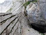 105
105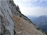 106
106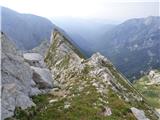 107
107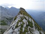 108
108 109
109 110
110 111
111 112
112 113
113 114
114 115
115 116
116 117
117 118
118 119
119 120
120 121
121 122
122 123
123 124
124 125
125 126
126 127
127 128
128 129
129 130
130 131
131 132
132 133
133 134
134 135
135 136
136 137
137 138
138 139
139 140
140 141
141 142
142
Discussion about the trail Suhadolnik - Turska gora