Starting point: Štufna (830 m)
| Lat/Lon: | 45,6807°N 15,0082°E |
| |
Time of walking: 50 min
Difficulty: easy marked way
Altitude difference: 269 m
Altitude difference po putu: 269 m
Map: Dolenjska 1:50.000
Recommended equipment (summer):
Recommended equipment (winter):
Views: 16.706
 | 2 people like this post |
Access to the starting point:
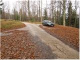
From the Ljubljana - Zagreb motorway, take the Ivančna Gorica exit and follow the road towards Črnomelj. Shortly after the village Obrh (located 1km before the village Podturn near Dolenjske toplice), the road will turn right and will lead us towards our starting point (direction Rog). Continue up the asphalt road to the next crossroads where the signs for Rog, Podstenice, the cemetery and Pogorelec and Primoži direct you to the right on the macadam road (straight ahead Resa, Base 20). Follow the dirt road, which has a few more junctions, in the direction of Rog. When you see a forestry hut on the left side of the road and a sign for Štufno next to it, pay attention to the mountain signs. Just a little further on we come to a crossroads where we see the mountain signs for Rog 1h. Here we park in the parking lot by the road.
From Novo mesto, drive through Dolenjske toplice to the village of Podturn. Here, turn right towards Žužemberk, then shortly after Podturn turn sharp left towards Rog. Continue as described above.
Access is also possible from Kočevje along forest roads.
Path description:
From the parking lot, take the worse road in the route Rog - vrh. Follow this road for only a short time, as the signs direct you to the left to cart track, which starts to climb steeply through the forest. "Follow cart track for about 15 minutes and then the signs direct you left up a less visible footpath which joins the path from the Scout Hut (Žaga Rog) at a higher level. Continue right here and follow cart track, which climbs only slightly. Further on, in addition to the usual markings, you will also see bear paw markings. After a few minutes of walking, cart track climbs more steeply and leads us to the base of the summit slope of Veliki Rog. Here, the markings direct us left again onto a footpath which climbs steeply and, after 5 minutes of further walking, leads us to the highest peak of the vast forests of the Kočevje Horn. From the top, you can climb to the lookout tower, which offers a beautiful view of the surrounding area.
Climb the wooden tower at your own risk.

Pictures:
 1
1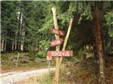 2
2 3
3 4
4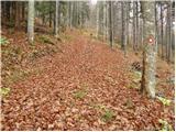 5
5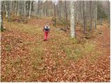 6
6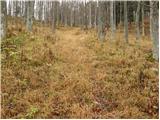 7
7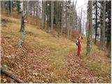 8
8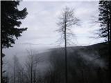 9
9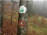 10
10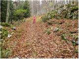 11
11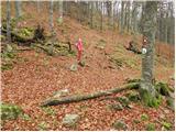 12
12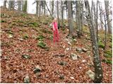 13
13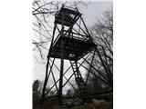 14
14
Discussion about the trail Štufna - Veliki Rog
|
| Lj1. 05. 2010 |
Vrh Roga smo obiskali po poti od Skavtskega doma na Žagi. Ko splezaš na razgledni stolp, ti je jasno zakaj Kočevski pravijo dežela gozdov. Širni gozdovi na vseh straneh. Zdaj je najlepši čas za netežaven pohod po tej poti: sveža zelena barva, tla prekrita s čemažem, udobna steza, primerna tudi za otroke (mi smo s sabo imeli še ne 3-letnika, ki je pohod opravil na lastnih nogah). 
|
|
|
|
| Saten17. 09. 2010 |
Včeraj sem se povzpel na Veliki Rog, ker je še v stari "Transverzali". Pa na njem nisem našel žiga. Morda kdo ve, kje se ga lahko dobi. Hvala lepa za kakršnokoli obvestilo. LP.
|
|
|
|
| odri9. 10. 2011 |
Kakšna je verjetnost, da na tej poti srečam medveda? Me je strah teh zveri, zato po teh kočevskih gozdovih ne hodim rada.Čeprav vem, da je tam doli zelo lepo.
|
|
|
|
| Lj9. 10. 2011 |
Ne velja več, da je le Kočevska dežela medveda, srečaš ga lahko na Bohinjskem koncu, na Krimu oz. v okolici Ljubljane, na Notranjskem in Primorskem(Nanos,Vremščica, Snežnik...). Praviloma se medved izogne človeka, če ga zazna. Moraš imeti res posebno srečo, da prideš napr. med medvedko in mladiča ali pa se zaletiš nepričakovano vanj ali pa firbcaš okoli njegovega brloga...
Jaz se pri hoji po kočevskih poteh sploh ne obremenjujem več z možnostjo srečanja z medotom, bolj se ga bojim srečati na cesti, kjer mi je že 5x skočil pred avtom čez cesto. Pa tudi pohodništvo je po vseh markiranih poteh že tako razširjeno, da ob koncih tedna prav na vseh poteh srečaš kakega pohodnika in verjetno tudi živali vedo, kdaj se je bolje izognit obljudenim potem. Lp, Ljubica
|
|
|
|
| Lj9. 10. 2011 |
No, še tole bi dodala. V Rogu sem enkrat srečala kolesarje z zvončkom na balanci, da so z cingljanjem opozarjali živali na svojo prisotnost. Če hodiš sam, si lahko takle zvonček privežeš na nahrbtnik, škodit ne more. 
|
|
|
|
| julius21. 04. 2013 |
Danes smo šli peš od Baze 20 do vrha Velikega Roga. Snega je še precej. Videli smo tudi veliko medvedjih stopinj, človeških pa skoraj nič.
Žig je zacementiran na desni, zunanji strani stolpa.
Včasih je potrebno pregledati tudi okolico stolpa, vrha itd., da najdeš kar iščeš.
|
|
|
|
| Ivica 19. 07. 2013 |
Kolk ste pa rabili peš od Baze 20 do Roga. Jaz namreč tečem vsak dan do Jeledola iz Dolejnskih toplic mimo baze 20, do Roga pa še nisem šel, imam pa v planu letos .Ivica.
|
|
|
|
| aditaker8. 01. 2015 |
Pozdravljeni, ker nisem iz vaših koncev me zanima kakšna je pot na veliki rog ali je shojena ali so snežni zameti ali ni večjih problemov? in kot drugo me še zanima kje poteka pot oziroma kje je izhodišče da bi šla z punco najprej na bazo 20 in še na veliki rog in koliko časa bi hodila, da vidima če se nama splača in kakšna je pot sedaj v teh zimskih razmerah, prosim za nasvet in še to nameravama iti sedaj to nedeljo in naju zanima če je na poti kakšen planinski dom tudi?
|
|
|
|
| grega_p4. 01. 2018 |
Res lep, miren, razgleden izlet.
Na poti od skavtskega doma je trenutno nekaj podrtih smrek, vendar so obvozi nekako logični, sedaj v snegu pa je tudi vse polno sledi predhodnikov.
Danes kljub malo oblačnemu vremenu prelepi razgledi na vse konce Slovenije - Julijske in Kamniško-Savinjske Alpe, Snežnik, Gorjance, Pohorje. In seveda še vse vmes.
Ker je vihar res naredil svoje tam doli, je treba biti previden, saj določene veje visijo v "zraku". Tudi pri vožnji z avtomobilom s kočevske strani je polno nagnjenih dreves. Ko sem se odločil, da grem z avtom naprej do Dolenjskih Toplic, pa mi je to preprečila ogromna smreka čez cesto. Dva sta poklicala in čakala na gozdarje, jaz pa sem raje obrnil in šel po isti poti nazaj domov.
Če vas zanimajo oddaljeni kraji, tišina gozdov, opuščeni zaselki kočevarskih vasi, so ti konci res prava odločitev. Pa seveda, ne pozabite, da je to domovanje medveda.
|
|
|