Smolnik - Veliki Šumik waterfall (on western ridge of valley Lobnica)
Starting point: Smolnik (277 m)
Name of path: on western ridge of valley Lobnica
Time of walking: 3 h
Difficulty: difficult marked way
Altitude difference: 673 m
Altitude difference po putu: 850 m
Map: Pohorje 1:50.000
Recommended equipment (summer):
Recommended equipment (winter): ice axe, crampons
Views: 9.339
 | 3 people like this post |
Access to the starting point:
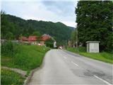
Smolnik is a settlement on the western side of Ruse, geographically stretching from Žigartovo vrh past Falski rybnik almost to Klopni vrh. From the centre of Ruse, head straight west along the asphalt road to Činžat odn. Lovrenc, passing the cemetery on the right. In Smolnik, under a typical railway viaduct, the road turns sharp right and then immediately left to a roundabout, where you continue straight westwards to an industrial hall, where there is a sign advertising GEBERIT on the right-hand side of the road. Here, a road sign indicates a large parking lot on the left-hand side of the road, and there is also a bus stop. From the centre of Ruse, just under 2 km.
Path description:
From the parking lot, follow the road west, after about 300 m before the last house on the left, turn left as the signpost for ZGORNJI SMOLNIK warns you. Follow cart track up the northern slope of Kluž, cross the railway via a small underpass, the path turns right and leads us past a small farm to a forest. Stepping onto the edge of the cart track, you have a view of the river Drava and the hills on the other side of the river. The path winds in serpentines through a mainly deciduous forest, in between there is a sharp left fork for the Lobnice valley, you will reach a narrow asphalt road (*30 min), you will walk along it for the next 2 km. We are at the top of the left bank of the Lobnice, whose murmur can be heard from the valley deep below us. From the left we can see the steep forest slopes on the opposite side of the valley, the imposing Marolt homestead is clearly visible. We will encounter several more such farms on our way; they are cultural monuments and have borne their names for a long time, although in some cases the owners have changed. Continue along the road below Globokar's Peak, after a while you will see a neat little chapel above the road and arrive at a saddle in the immediate vicinity of the Globokar homestead (* 20 min). To the right, to the north-west, a view opens up over part of the Drava Valley. The Falska Cliff is clearly visible, and behind it the Falska Manor House, which was first mentioned in 1245, but today's design dates back to 1407. Upriver, you can see the oldest hydroelectric power station in the Drava, Fala, which was completed in 1918; the engine room from that time is fully preserved and today represents the largest technical monument of its kind in this part of Europe. The road climbs steadily, before the Harič homestead the asphalt is over, in a few minutes you will pass the Cebe homestead, a bit downhill and immediately at the bend turn left uphill into the forest (* 15 min). At cart track you will soon come across a somewhat hidden NOB memorial, on this place there was a clash between a patrol of the Ruška troop and two German gunmen on 17. 07. 1942. Through the forest you will reach a meadow below Švajger's homestead, cross the meadow on the right side along the edge of the forest upwards. At a crossroads with many signposts, follow the road up to the right and then immediately left to a small church (* 35 min). The church was built in 1860 by farmer Luka Hleb on his estate, dedicated to St Mary and blessed by Bishop Anton Martin Slomšek. It is surrounded by a small cemetery with the tomb of the Hleb family. Right next to the church is a crossroads, up to the right is the trail to Klopni vrh, and a signpost "Šumik" directs you straight along a well-marked path along the upper edge of the meadow, above the cottage turn right up into the woods, and you will emerge above Hleb's cottage. Immediately after the house there is a marked fork in the trail, we turn left downhill in the direction of "Šumik-skozi pragozd", a minute later we are on the well-known macadam road, which we continue uphill on the right. In less than a kilometre we reach a well-marked crossroads (* 10 min), where signposts direct us off the road to the left down the cart track, which descends diagonally down the slope. The shining rock along the way is blestnik, the most abundant in Slovenia, right on Pohorje. Cross the footbridge over a small stream and continue along the path until you reach a point where the path from the Lobnica valley, also called the Holcarska path, joins from the left, continue up to the right (* 15 min). The Lobnica roars steeply below us, the dark green isolated rocks along the path become more and more frequent and merge into the rocks above us, called Jelenska peč (Deer Furnace). For botanists, this is an interesting place to find the rusty mallow, which is common in Slovenia only on Pohorje, as it needs acidic soil to grow. The entire surrounding area and the rocks are covered with lush vegetation, which has not been deliberately disturbed by man in order to preserve the original mixed Pohorje forest. The dangerous torrential ravine is crossed via a wooden footbridge, which is the longest bridge on Slovenian mountain trails with a length of 14. 5 m. It was built by the markacists of Podravje in 2002, as indicated on the information board in front of the bridge. If you want to see the waterfall in its entirety from the lower side, you have to go down the slope a little before the footbridge to the Lobnice (carefully!) near the place where you can see the remains of the suspension footbridge, which was attractively laid directly above the waterfall, but unfortunately it was destroyed by natural forces some time ago (*25 min). If you want to see the waterfall in its entirety from the lower side, you have to go down the slope a little before the footbridge (carefully!). A few metres higher above the waterfall, the markasts have built a replacement footbridge, over which we continue our journey along the right side of the Lobnice gorge, our eyes drawn to the stretched water that spills over moss-covered rocks and the remnants of tree trunks in the riverbed. After a few minutes, we reach the waterfall of the Verna stream, which we cross with the help of a rope, continue over the Lobnica and arrive at the place where the most famous view of the Veliki Šumik waterfall opens up (* 15 min).

Pictures:
 1
1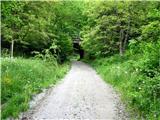 2
2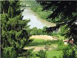 3
3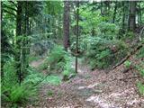 4
4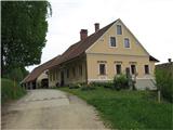 5
5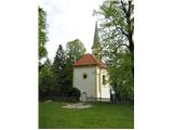 6
6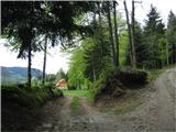 7
7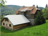 8
8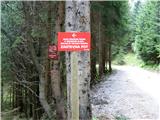 9
9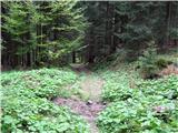 10
10 11
11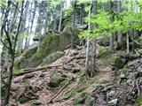 12
12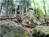 13
13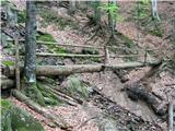 14
14 15
15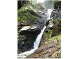 16
16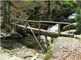 17
17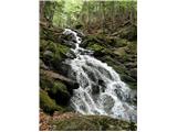 18
18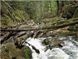 19
19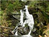 20
20
Discussion about the trail Smolnik - Veliki Šumik waterfall (on western ridge of valley Lobnica)
|
| VanSims16. 10. 2011 |
Avtorju pohvala za zelo dober opis poti: ne samo natančno kam je treba iti ampak tudi znamenitosti ob poti so lepo opisane.
Sicer je sama pot po moje bolj delno-zahtevna. Seveda do slapa čez pragozd. Naprej do parkiršča na Bajgotu pa seveda je zahtevna, še posebej v obratni smeri.
|
|
|
|
| pohodnik3816. 10. 2011 |
Se strinjam z VanSims lepo opisano in kar vabi tako da v bližnji prihodnosti obiščem 
|
|
|
|
| gzoli11. 03. 2014 |
Hello, which is the best part of the Lobnica gorge ? Is it nice from down the valley or just around the two waterfalls ?
|
|
|