Smolnik - Koča na Klopnem vrhu
Starting point: Smolnik (277 m)
Time of walking: 3 h
Difficulty: easy marked way
Altitude difference: 983 m
Altitude difference po putu: 1179 m
Map: Pohorje 1:50.000
Recommended equipment (summer):
Recommended equipment (winter):
Views: 8.264
 | 1 person likes this post |
Access to the starting point:
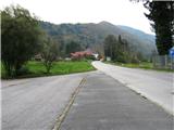
Smolnik is a settlement on the west side of Ruse. From the centre of Ruse, drive straight west on the asphalt road to Lovrenec, past the cemetery on the right, in Smolnik, under the characteristic railway viaduct, the road turns sharp right, then straight to the industrial hall, where the GEBERIT sign is on the right side of the road. Here, a road sign indicates a large asphalted parking lot on the left hand side of the road, where you park your car. From the centre of Ruse, just under 2 km.
Path description:
From the parking lot, follow the road west, after about 300m before the last house on the left, turn left, as the signpost for ZGORNJI SMOLNIK warns. Follow cart track up the northern slope of Kluž, cross the railway via a small underpass, the path turns right and leads us past a small farm to a forest. Stepping onto the edge of the cart track, you have a view of the river Drava and the hills on the other side of the river. The path winds in serpentines through a mainly deciduous forest, in between there is a sharp left turn off the Šumiku path (along the Lobnice valley), you reach a narrow asphalt road (*30 min), you will walk along it for the next 2 km. We are on the western bank of the Lobnice valley, whose murmur can be heard deep below us. From the left we have a view of the steep forest slopes on the opposite side of the valley, the imposing Marolt homestead is clearly visible. We will encounter a few more such farms on the way; they are cultural monuments and have borne their names for a long time, although in some cases the owners have changed. Continue along the road below Globokar's Peak, after a while you will see a neat little chapel above the road and arrive at a saddle in the immediate vicinity of the Globokar homestead (* 20 min). To the right, to the north-west, a view opens up over part of the Drava Valley. The Falska Cliff is clearly visible, and behind it the Falska Manor House, which was first mentioned in 1245, but today's design dates back to 1407. Upriver, you can see the oldest hydroelectric power station in the Drava, Fala, which was completed in 1918; the engine rom from that time is fully preserved and today represents the largest technical monument of its kind in this part of Europe. The road climbs steadily, before the Harič homestead the asphalt is over, in a few minutes you will pass the Cebe homestead, a bit downhill and immediately at the bend turn left uphill into the forest (* 15 min). At cart track you will soon come across a somewhat hidden NOB memorial, on this place there was a clash between a patrol of the Ruška trop and two German gunmen on 17. 07. 1942. Through the forest you will reach a meadow below Švajger's homestead, cross the meadow on the right side along the edge of the forest upwards. At a crossroads, follow the road up to the right and then immediately to the left to reach a small church (* 35 min). The church was built by farmer Luka Hleb on his property in 1860 and is being restored. It is surrounded by a small cemetery, here is the tomb of the Hleb family. The tombstones, which are more than 100 years old, bear inscriptions in Slovene, which testifies to the strong national consciousness of the local inhabitants. Right next to the church is a crossroads - the left path is for Šumik, and we continue right up into the forest. After a while, unexpectedly, a view of Ruše opens up on our right, and a little further on we can see part of Maribor. A pleasant, almost horizontal path leads us leisurely through the forest, crossing a few small streams, and at the bridge over Lamprehtov potok we reach a macadam road leading to Klopný vrh (* 50 min). Follow the road left up, over a wooden bridge across the stream again to Fišer's sawmill odn (Fišer's sawmill). Only the names of the sawmill and the glažuta have been preserved, today there are holiday homes. At this point turn l

Pictures:
 1
1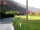 2
2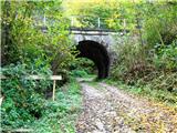 3
3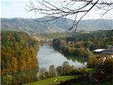 4
4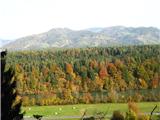 5
5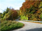 6
6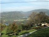 7
7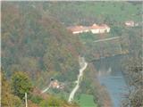 8
8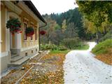 9
9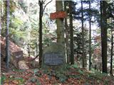 10
10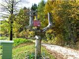 11
11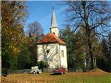 12
12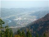 13
13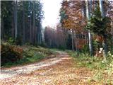 14
14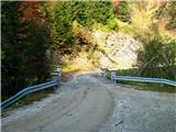 15
15 16
16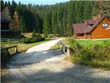 17
17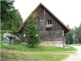 18
18
Discussion about the trail Smolnik - Koča na Klopnem vrhu
|
| gasilec23. 10. 2008 |
V Rušah nas prometni znaki opozorijo, da je cesta Ruše - Lovrenc zaprta odn. je prevozna samo do Falske Pečine (predvidoma do 30.11.2008). Za navedeni izlet to ne predstavlja težav, saj je naše izhodišče cca 2 km pred navedeno zaporo.
|
|
|
|
| klavdy617. 04. 2010 |
Pot je v tem času daljša zaradi podiranja dreves, blata in snega, ki ga je malo pred kočo še precej. Drugače pa zelo zanimiv izlet.
|
|
|