Starting point: Šentjur (280 m)
| Lat/Lon: | 46,2026°N 15,3932°E |
| |
Time of walking: 1 h 30 min
Difficulty: easy marked way
Altitude difference: 402 m
Altitude difference po putu: 402 m
Map:
Recommended equipment (summer):
Recommended equipment (winter):
Views: 61.676
 | 3 people like this post |
Access to the starting point:
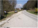
From the motorway Ljubljana - Maribor take the exit Dramlje and follow the road in the route Šentjur. In Šentjur, at the traffic lights, continue straight into the underpass under the railway line and follow the road in the direction of Šentrupert. Just past the sign at the end of Šentjur, you will see a parking lot on the right side of the road and mountain signs for Resevno.
Path description:
From the parking lot, continue along a side road that crosses the Kozarica River via a bridge. The path then leads past a few houses to a chapel, where the deteriorating road makes a right turn. In the middle of the bend, the marked path to Resevno branches off up to the left. There is a cross-country climb through lane of a forest, and then the path leads us back to the grassy slopes. The path then goes into the forest, and after a few minutes leads us to a small hamlet, where we get on the road. The road descends gently and leads to a crossroads, where you continue uphill to the right. The ascent continues on a dirt road which changes to cart track at a higher altitude, which leads to a fork in the path, where we continue to the right, up a steep footpath. After a short steep climb, rejoin the road, which you follow in the direction of Resevna. After a few dozen steps along the road, a marked footpath points right upwards. This climb does not take long either, and we are back on the road. Continue past the cross, along the road closed to traffic, which climbs moderately and leads us after a few minutes' walk to the mountain home.
From home, we continue along the gently sloping path, which after a few steps leads us to the top, in the middle of which is placed a 20m high lookout tower.

Pictures:
 1
1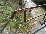 2
2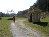 3
3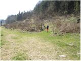 4
4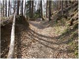 5
5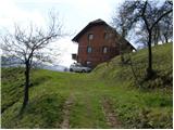 6
6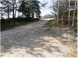 7
7 8
8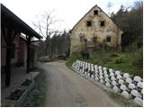 9
9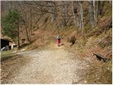 10
10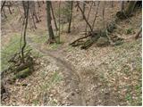 11
11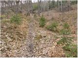 12
12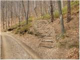 13
13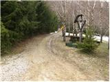 14
14 15
15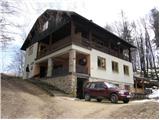 16
16 17
17
Discussion about the trail Šentjur - Resevna
|
| pohodnica532. 04. 2009 |
Zanima me ali kdo ve, če je planinski dom na Rasevni v tem času odprt, npr: to soboto 4.4.09 
|
|
|
|
| pohodnica535. 04. 2009 |
čeprav sem Savinjčanka, sem bila danes prvič na Resevni; nikoli se nisem poglabljala, kje to je, k sreči pa imamo ta forum, da človek najde kaj pametnega, pa še pot ima lepo opisano; moram reči, da je čudovita planinska pot (ca 1 uro hoda), vseskozi vzorno označena, prijetna koča in klopce zunaj ter prijazna oskrbnica; tudi sto je zelo O.K. in ti daje možnost širšega razgleda; žal mi je le, da je že prej nisem odkrila, saj se bom še rada vračala; vsi, ki jo še niste obiskali, storite to čimprej, ne bo vam žal, sploh če bo sonček, tako kot danes;  prijazno  pa pozdravljam tudi simpatične planince iz Ljutomera in jim želim še veliko prijetnih planinskih poti in užitkov ob tem;lp
|
|
|
|
| jozo25. 04. 2009 |
Lep sončen dopoldan sem izkoristil za pohod na Resevno. Prijeten sprehod iz Šentjurja in prijazna oskrbnica v domu, ti še tako polepša dan. Jutri pa malo više, seveda, če bo vreme dopuščalo. Pozdrav vsem…
|
|
|
|
| uhan110. 08. 2011 |
Zanima me, kje se dobi žig med tednom, ker je koča odprta samo med prazniki in vikendi? Hvala
|
|
|
|
| Kokta22. 01. 2012 |
Zdravo...lepa turica od mlina do vrha. Žal žiga ni pri stolpu, ker ga je nekdo odrezal. Pozdrav zelo prijaznemu oskrbniku koče.
|
|
|
|
| artur3. 03. 2012 |
Smo bili danes z družino na Resevni.
Nobenega snega več, pa tudi blata ni.
Prijazen oskrbnik. Baje je odprto vsako soboto in nedeljo.Škoda da je bilo megleno, drugač je baje lep razgled.
Verjamem, da je poleti, ko je topljše, Šentjurčani radi zasedejo klopi okoli Planinskega doma.
Pa še mogoče kdaj.
|
|
|
|
| nietka19. 02. 2015 |
Pri hiši na sliki št. 6 je zdaj tabla ''privatno zemljišče, prehod prepovedan''. Ve kdo, kako obiti to hišo oz. kako priti na cesto tako, da ne greš čez njihovo zemljišče? Kar nerodna zadeva 
|
|
|
|
| bruny22. 02. 2015 |
Privatno zemljišče je bilo itak verjetno skozi celoten čas kar vodi tukaj pot. Ne vem, če lahko kar tako prepovedo prehod. Prehod v širini najmanj enega metra morajo omogočiti. Morda pa prebere kdo iz PD Šentjur, predvidavam da oni upravljajo s potjo in zapiše kako in kaj je na stvari!?.
|
|
|
|
| marchy1. 03. 2015 |
Zavedamo se tega problema, ki je nastal, ko smo registrirali Gaberškovo pot na PZS. Trenutno potekajo intenzivni pogovori z lastnikom omenjene parcele in upamo, da bomo ta problem v najkrajšem možnem času rešili. Za nastalo situacijo se v imenu PD Šentjur vsem pohodnikom iskreno opravičujem in predlagan, da za vzpon na Resevno uporabijo kakšno drugo pot. V našem planinskem domu na Resevni pa uživajte v kulinaričnih dobrotah in čudovitem razgledu na bližnjo in daljno okolico, ki se ponuja iz našega razglednega stolpa. M.R. član UO PD Šentjur
|
|
|
|
| Janiel744. 06. 2016 |
In ste se kaj zmenili? 15 mesecev je že od tega. Je pot normalno prehodna? Hvala za info.
|
|
|
|
| slavkoo16. 06. 2016 |
Halo!!? A nobeden ne ve odgovora? Je lastnik parcele na položajih s fračo al ne?
|
|
|
|
| Janiel7416. 06. 2016 |
Kolikor mi je omenila lastnica Planinskega doma na Resevni naj bi se letos pot tam speljala malo naokoli, da ne bo več zapletov.
|
|
|
|
| jvali10. 09. 2016 |
Lepa pot. Odlični štruklji in jabolčni kompot, dobra kava in prijazno oskrbnica. Lepi razgledi s stolpa in prijetna družba gor-dol. Specialke smo zakon!
|
|
|
|
| slavkoo8. 06. 2018 |
Janiel 74....Pot je res speljana malo naokoli žal pa brez markacija. Zadnja vidna je nekaj metrov od izhodišča pri kapelci, potem pa šele ko prideš do manjšega naselja. Precej nerodno, ker je kopica poti na vse strani. Če ne bi šel nazaj s prijaznim domačinom, ki se je čudil da ni markacij, bi kdo ve kje prišel do vznožja. Sicer pa v koči prijazni, lep razgled s stolpa.
|
|
|
|
| bo_zl29. 12. 2021 19:56:46 |
Danes po tej poti. Še vedno velja, markacij ni, poti pa kolikor hočeš. Ko pridete do kmetije boste na kozolcu videli markacije. Naj vas opis poti ne zavede. Od kmetije se gre po rahlo vzpenjajoči cesti, v križišču kjer so reklame za čebelarstvo zavijete levo in ne desno kot piše v opisu. Nato cesti sledite do križišča kjer zavijete desno v hrib. Nato nadaljevanje ni več težavno, ker je tudi dobro markirano.
|
|
|
|
| lepenatka6. 04. 2023 19:26:33 |
Še vedno enaka situacija glede markacij. Je pa nekdo na večih mestih označil pot z rdečimi pikami in kako puščico. Je pomagalo, čeprav ni v skladu s pravili in je speljana malo drugače kot v opisu. Na vrh sem pa le prišla
|
|
|
|
| Tomaž0026. 05. 2023 15:41:31 |
A je po tej poti kaj problemov z orientacijo, kaj pa parkiranje ob cesti je dovoljeno? Hvala za odgovor
|
|
|
|
| garmont26. 05. 2023 19:33:35 |
Parkira se točno tu, kjer je opisano in je prostora za cca 6 avtov. Markacije so pa bolj redke, je pa pot precej dobro vidna. Kar korajžno.
|
|
|