Ruski križ - Križ (circular path through kingdom of Zlatorog)
Starting point: Ruski križ (1000 m)
| Lat/Lon: | 46,4444°N 13,7746°E |
| |
Name of path: circular path through kingdom of Zlatorog
Time of walking: 12 h
Difficulty: very difficult marked way
Altitude difference: 1410 m
Altitude difference po putu: 2766 m
Map: Triglav 1:25.000
Recommended equipment (summer): helmet, self belay set, ice axe, crampons, lamp
Recommended equipment (winter): helmet, self belay set, ice axe, crampons, lamp
Views: 9.594
 | 4 people like this post |
Access to the starting point:
First drive to Kranjska Gora, then continue driving towards the Vrh Leh pass just before the 3rd serpentine of the Ruska or vršiška road, you will see the Russian Cross on the right and a small parking lot on the left, where you park. As the parking lot is relatively small and quickly full, you can also park a little higher up in the larger parking lot just above the 4th serpentine (in this case we have to descend a little to our starting point at the Russian Cross).
The starting point can also be reached from the coastal side via the Vršič Pass.
Path description:
From the parking lot, continue along the road, which after a few steps leads to Mihov's home on Vršič.
The ascent continues along the serpentine road, where just a few steps after the eighth bend you reach a small crossroads, where the path to the Russian Chapel branches off to the left. After a short climb up some stairs, we reach the chapel, and we continue slightly to the right, where we rejoin the Vršiška cesta in a few steps. We continue our ascent along the road, from which a marked path branches off a little higher to the right towards Erjavec's hut.
Continue on the right path and after a few steps of further walking we will reach the next crossroads, where we continue on the left path (right unmarked path to Kumlehova glava and Visoki Mavrinc). The poorly marked path crosses a small spring a little higher up, then turns left, where it then climbs through the forest for some time. Higher up, we leave the forest, and the path leads us just a little further to Vršiška or Ruska cesta. Follow the road or shortcut all the way to Erjavčeva koča na Vršiču, only to reach it after a few minutes of further walking. After the cottage, follow the path leading into the forest and soon you will see a ravine leading towards the S foot of Prisank. Go down the ravine for about 300 metres and then turn right. Past the dense dwarf pines and trees, you will reach the head of the ridge, which leads to a scree slope, where you will then head towards the Hanzo trail on Prisank. This route then leads to the entrance to the climbing section of the route, which is located near a small waterfall.
At the entrance to the wall, continue slightly to the right and start to climb using pegs and ropes. The path then leads to another waterfall, which is crossed with the help of wedges. This is followed by a slightly less demanding traverse of the steep slopes to the west. Later, the path turns left and climbs past some dwarf pines. On the right, there is a fine view towards a slightly larger waterfall falling over steep cliffs. There is a slightly steeper climb up a mostly unprotected slope, and then the path turns right into the wall and climbs steeply along a number of steel cables and a ropeway. Then it crosses the slightly exposed slope again. The path leads past a small statue of the Virgin Mary, which is located to the left in the rock face. The path then turns slightly to the left and is followed by a short descent with the aid of wedges and a rope which leads to a snowfield. The snowfield usually remains all year round, and it is essential to have a snowshoe and snowshoes to cross it. On the other side of the snowfield, the path then turns slightly right and becomes easier. Climb up the grassy slope past some larch trees, then continue westwards and cross the precipitous slopes on ledges. The slope then becomes less steep again and the path leads to a crossroads at 1800 metres. The path to the right leads to Prednje okno, and we continue to the left along the Hanzo route. After a short, easy climb, you then climb steeply along the steel cliff several times with the help of a number of pegs. The route then leads to the fairly gentle slopes on the south side of the summit of Hanzov Turn (2040 m). There is usually another snowfield here, but it is much less steep than the first one.
Continue slightly right under the steep walls of Prisojnik and then climb up a slightly rubbly gully towards a notch on the south side of the summit of Hudičev steber (2237 m). There is also a signing-in book here before entering the very difficult part of the route.
The route then climbs almost vertically with the help of a rope and pegs, and then crosses the precipitous slopes to the west on ledges. Later, the path turns left and starts to climb up the rather steep northern slopes. This part of the route is mostly unprotected and a little more caution is needed. The path then turns to the left and follows a less steep slope to the north-eastern side of the summit. Here the path becomes very difficult again and first climbs vertically on scrambles and then on a slightly exposed slope with the help of a rope and pegs. From here it is only a short climb to the top of Prisojnik.
The Hanzo route to Prisojnik is the longest protected climbing route in Slovenia and is also one of the most technically demanding. Due to the snowfields on the route, it is compulsory to use snowshoes and snowshoes even in summer.
From the top of Prisojnik, descend along the marked Jubilee Trail, which leads out the back window. The path is very exposed, so it is not superfluous to use a self-protection kit and a helmet (especially in the Window!). We leave the trail just after the notch between Prisank and Razor (1995 m. a. s. l. ). The trail continues crossing the slopes below Razor and leads us just a little further to the entrance to the more technically demanding part of the trail. With the help of fixed safety gear we climb up a short wall, which does not present any major problems. The route then heads south and towards the Tired Tower. Soon we are at the Planja saddle, where the path from Pogačnik's home joins us. Go left here (right Planja) and continue the ascent along the path, which is beautifully laid out along natural passages (slightly exposed in places). Higher up we see a cave where snow and ice stay almost all year round. The path then turns slowly to the left and soon you are walking on an exposed shelf. The path then turns right to the other side of the ridge. A few more steps of easy climbing and we are at the top. From Razor we descend to Kriška Pod Pode, we can turn off the trail for five minutes and have a snack in Pogačnikov dom na Kriških podih (2050 m. n. m. ), or we can continue on towards Križ (2410 m. n. m. ).
From Pogačnik's home, continue in the direction of Razor and Križ along the path, which descends slightly and leads in a few steps to the next crossroads, where you go right (left Razor). We continue to climb up the initially gently sloping, then slightly steeper path, which leads us across the karst world of the Kriški Podov. Slightly higher up, a path branches off to the right (or straight ahead), leading to Zgornje Kriško jezero, and we continue straight ahead (or left) on a path that crosses the steep slopes of Kriški rob higher up. When the path reaches the ridge at the end of the Kriški rob crossing, we have a glimpse of the 2382 m high Šplevta (the mountain in the shape of an Indian). Next, the path climbs steeply over the broken rocks (danger of slipping) and leads us higher up to the Bovška vratica (Bovška vratica). Continue right towards the top of Križ (straight ahead Škrlatica, Dolkova špica, Cirque and the bivouac at Dwarf pines), which is only a 10-minute walk away. The way ahead first climbs gently along an increasingly narrow ridge, then climbs steeply with the help of a ropeway over a slightly exposed rock slab, after which you reach an interesting passage through a natural chute. With some skill, you can climb through the narrow chute to the viewpoint of Križ.
From Križ, descend to the top of Kriška Stena (2289 m) and follow the protected mountain path towards Cirque. From Cirque we then have only a leisurely walk back to the 3rd serpentine. This completes the circle.
We have made about 2800 vertical metres on this route. It is wise to walk the route in late summer because of the snowfield. It will require you to be in maximum physical condition (fitness), your psyche in place and your camera working. (Possibility of sleeping on the Kriški pod podi) For all those who will undertake this circular route, the immense beauty of the Julian Mountains, the dark S wall Prisank, and the pastures and karst world of the Kriški podi await you. For those who really want to get the most out of their trip, you can extend it to the Stenar hill (2501 m. a. s. l. ), an hour's walk from Križ.
Walking time: 3rd serpentine road-Prisank (Hanzova) 5 hours, Prisank-Saddle Planja 2 hours, Planja-Razor 1 hour, Razor-Kriški podi 45 minutes, Kriški podi-Križ 1. 5 hours, Križ-Križ-Top of Kriška stena 10 minutes, Stena-Krnica 1. 5 hours, Krnica-point of departure 30 minutes.
The times are for information only and do not take into account breaks along the way, which will certainly occur.

On the way: Mihov dom na Vršiču mountain hut (1085m),
Ruska kapelica (1130m),
Erjavčeva koča na Vršiču mountain hut (1525m),
Prisank / Prisojnik (2547m),
Zadnje okno (2200m),
Sedlo Planja (2349m),
Razor (2601m),
Sedlo Planja (2349m),
Pogačnikov dom na Kriških podih mountain hut (2050m),
Bovška vratica (2375m),
Križ (2410m),
Bovška vratica (2375m),
Vrh Kriške stene (2289m),
Koča v Krnici mountain hut (1113m) We can extend the trip to the following destinations: Stenar
Pictures:
 1
1 2
2 3
3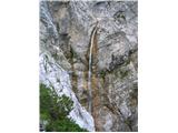 4
4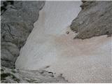 5
5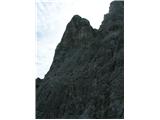 6
6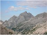 7
7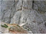 8
8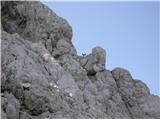 9
9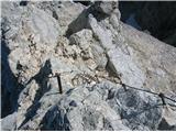 10
10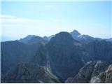 11
11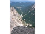 12
12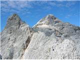 13
13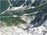 14
14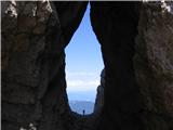 15
15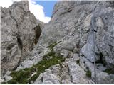 16
16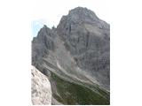 17
17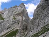 18
18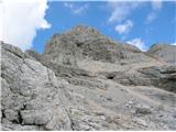 19
19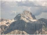 20
20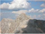 21
21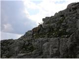 22
22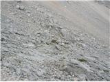 23
23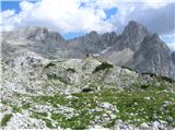 24
24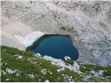 25
25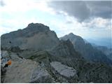 26
26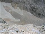 27
27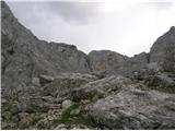 28
28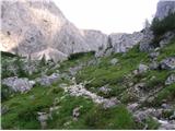 29
29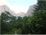 30
30 31
31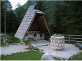 32
32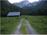 33
33
Discussion about the trail Ruski križ - Križ (circular path through kingdom of Zlatorog)
|
| Hribolaznik6. 07. 2015 |
Ta vikend sva opravila to čudovito pot, hvala avtorju za predlog. Rad bi opozoril na časovna neskladja v opisu. Hanzova pot iz Koče na gozdu do vrha Prisanka je dolga 5 ur, kar logično pomeni da od ruskega križa do vrha je več kot 5 ur. Avtor navaja da je od vrha Prisanka do sedla Planja 2 uri. Ah kje. 2 uri sta do Zadnjega okna (tehnično zahtevno), potem pa še 2 uri 30 min do sedla. Ker se zadnji del lahko kdor zmore tudi preteče, bi tu označil Prisank - sedlo Planja od 4 do 5 ur. Od sedla do vrha Razorja je ura hoje do Pogačnikovega doma pa 45 min. Če povzamem je pot od ruskega križa do Pogačnikovega doma dolga cca 10 ur 45 min (brez postankov in brez vzpona na Razor). Na koncu pa še ena malenkost, vrh kriške stene - Koča v Krnici 2 uri 45 min. Izjemna pot, še enkrat hvala, lp.
|
|
|
|
| janezs7331. 08. 2015 |
Z zeno sva konec prejsnjega tedna opravila tale krog, sicer ne v enem dnevu, ampak v dnevu in pol, pa nic zato... zelel sem, da uziva v lepotah Jubilejne, kjer je prvic hodila... na Hanzovi pa sva ze nekajkrat bila - letos je Hanzova povsem brez snega - v Hudicevem zlebu je prav morece gledat raznobarvno melisce, kjer bi moralo biti nekaj metrov debelo snezisce...
morda le opozorilo za tiste, ki se Krizke stene lotite navzdol (meni je tole uslo iz spomina): vecino poti prek Krizke stene ni zavarovane z jeklenicami, kamor bi se lahko samovarovali (npr. s SVK), tudi markacije so mestoma v smeri navzdol tezje sledljive, zato je potrebno biti povsem zbran. dva prehoda v srednjem delu sta prek zagruscenih strmih last, precej izpostavljeno, brez varovalne jeklenice; za nekoga , ki ni navajen takega spusta, je to lahko nevarno.. potrebno je le umiriti korak, pa gre cez; saj so sicer lepi oprimki, samo psiha lahko pri nekaterih naredi svoje
PD Kranjska gora bi lahko razmislilo in tu cez dodalo dve jeklenici, s cimer bi bila pot za mnogo bolj varna
|
|
|
|
| janezs7331. 08. 2015 |
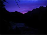
hvala! bila sta enkratna dneva in noro lepa noc (eno slikico prilagam), moje misli pa med temi vrsaci vedno odtavajo na greben onkraj Skrlatice (VO-VR-Skrlatica).. enkrat pridem tudi jaz tja, kjer sta vi asi doma
|
|
|
|
| janezs7331. 08. 2015 |
pozabil sem, da se da slikice prilagat le pri razmerah (dal sem jih pod Stenar, Kriz).. Jus, tista o noci je slika 10
|
|
|
|
| qunc18. 09. 2023 09:43:22 |
Sva prehodila to pot, sicer v nasprotni smeri (s spanjem v Pogačnikovem domu). S tem da sva na koncu izpustila zadnji del vzpona na Prisank in se iz zadnjega okna vrnila čez Kajzljevo škrbino na Vršič. Prvi dan, od ruskega križa do Pogačnikovega doma: 4,5h, drugi dan od koče na Razor, skozi zadnje okno po jubilejni mimo prisanka na Vršič: 9h. Tako da ja, vse skupaj kot je v zgornjem opisu je kar za računat 14h neke normalne hoje brez postanki.
|
|
|