Rifugio Tolazzi - Monte Coglians (Hohe Warte) (Weg der 26er)
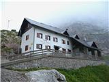
Starting point: Rifugio Tolazzi (1350 m)
| Lat/Lon: | 46,59199°N 12,8678°E |
| |
Name of path: Weg der 26er
Time of walking: 5 h 30 min
Difficulty: extremely difficult marked way
Ferata: D
Altitude difference: 1430 m
Altitude difference po putu: 1430 m
Map: Tabacco 01
Recommended equipment (summer): helmet, self belay set
Recommended equipment (winter):
Views: 17.983
 | 4 people like this post |
Access to the starting point:
From Ljubljana, take the Gorenjska motorway, exit Hrušica, continue via the Rateče border crossing to Trbiz. There, turn onto the motorway, leaving at the Tolmezzo exit. Continue to Villa Santina and continue along a good road in the direction of Ovaro, Comeglians, Rigolato to Forni Avoltri. Here we turn right onto a narrower road towards the villages of Sigilletto, Collinetta and Colina to our starting point, the Tolazzi hut. The whole journey from Ljubljana to the parking lot takes 2 hours and 40 minutes.
Path description:
From the parking lot, turn left at the Tolazzi hut along the road leading to the Morareet cheese cottage. We don't go to it, but the signs for route 144 soon direct us to the left onto another dirt road, from which we turn off after three switchbacks onto a forest track. This leads to the Lamberthengi hut, a few minutes below the Passo Volaia pass. Above it, you can see the Wolayer see lake with the Austrian Eduard Pichl Hutte on the opposite bank. On the right bank of the lake, descend gently along the 403, which turns in the direction of the high mountain cirque towards the next pass, Valentin Torl. You have to climb 270 vertical metres to reach the rock pinnacle just before the pass. Go around the bottom on the right and rejoin the marked path at the pass.
From here onwards, we ascend in keys towards the Hohe Warte escarpment. After about 20 minutes, look out for the trail branching off to the right, leading into the Weg der 26er ferrata, marked 427-1. As there are several paths down the slope, you can quickly miss the markings in the fog. In early summer, there may also be extensive snowfields. Follow the path to the entrance to the ferrata, which is marked with a sign. Equip yourself with a helmet, self-protection kit and climbing gloves (essential).
The initial part of the route is practically vertical. The wall is well broken, the rock is compact, the belays are continuous. There are enough steps, but they are quite far apart, so you need a lot of energy to progress. Soon we are loking at a concrete depth under our shoes :) The vertical part turns into a traverse of smooth, wet rock with no chance to rest. There is practically no support for the feet, or very shallow natural holes in the rock. It will help if we lok at and remember the key points and cross the rock in one go. There is a resting place on the other side, where the path turns vertical again. The way ahead is still challenging, but the key points are behind us. Once you reach the box with the signing-in book, the path slowly turns into the ridge section. With easy climbing and expansive views, we reach the summit, where we can congratulate ourselves :)
Descent :
The easiest way to return to the Hohe Warte is to follow the normal approach route, which is the southern route 143. Descend on rough terrain, where care is needed with slipping and sliding stones. The route is in the keys and is accordingly exposed to impact, as most of the approaches to Hohe Warte are made here. Helmets belong on your head here to, not in your rucksack :) Lower down, you reach a junction where you take the upper route 145. This leads over the grassy Pic Chiadin peak to the Marinelli hut with a nice view. We continue in the direction of our route 143 to the Morareet cheese cottage and past it to our starting point, the Tolazzi hut.

Pictures:
 1
1 2
2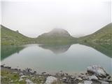 3
3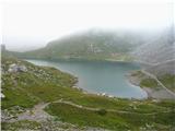 4
4 5
5 6
6 7
7 8
8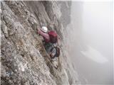 9
9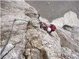 10
10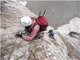 11
11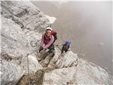 12
12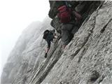 13
13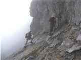 14
14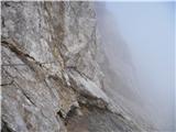 15
15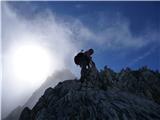 16
16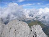 17
17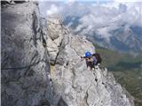 18
18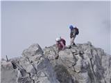 19
19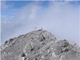 20
20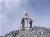 21
21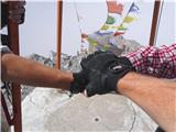 22
22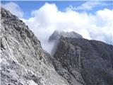 23
23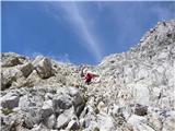 24
24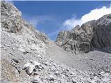 25
25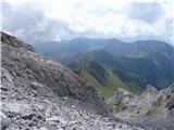 26
26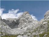 27
27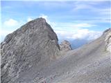 28
28 29
29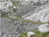 30
30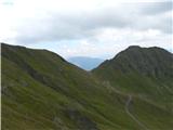 31
31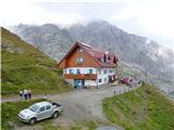 32
32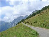 33
33 34
34
Discussion about the trail Rifugio Tolazzi - Monte Coglians (Hohe Warte) (Weg der 26er)
|
| ljubitelj gora20. 06. 2012 |
Tole ferrato sem še z nekom preplezal preteklo nedeljo, začela sva na Avstrijski strani, pot je prehodna brez zimske opreme, nekaj malega je še bilo snega, prvi del poti je res težak, namreč imela sva še mokre skale, gladka skala, malo stopov kasneje pa pot postane lažja, varovala so vredu, povratek po južni strani, pazljivo zaradi padanja kamenja.
|
|
|
|
| Darxta4. 10. 2013 |
N46.591867 E12.867576 Lahko preveriš na Google Maps, je celo Street View do koče. Pa srečno!  LP, Dare
|
|
|
|
| darinka423. 05. 2015 |
To ferato monte Coglians smo preplezali pred nekaj leti. V spominu mi je ostala začetna navpična stena ,bilo je poleti štirje smo bili lepa ferata. Vračali smo se po južni strani .Vzpon je zahteven, in treba je biti dobro pripravljen..
|
|
|
|
| B.Smart10. 07. 2017 |
V soboto preplezali tole ferato. Takoj na začetku je še manjše snežišče, ki se zaključi s precej široko razpoko od skale, tako da je vstop v steno še nekoliko težji. Poleg tega mokri čevlji niso ravno v pomoč pri premagovanju začetnega stebra. Ferata je drugače zanimiva, lepo speljana in polna izzivov. Zajle so ponekod bolj, ponekod manj napete, v pomoč nam je nekaj stopov in usekov v skalo. V tej ferati je resnično pomembna pravilna tehnika plezanja po feratah in moč v rokah. Priporočam, da imate poleg kompleta za samovarovanje tudi popkovino, saj vam predvsem v prvem delu omogoči počitek za roke. Pot je primerna za ljudi, ki imajo dobro psihofizično kondicijo, saj prepadne stene in kak manjši zdrs hitro načnejo živce.
|
|
|