Starting point: Pod Krnico (1250 m)
| Lat/Lon: | 46,4346°N 14,4083°E |
| |
Time of walking: 1 h 15 min
Difficulty: easy unmarked way
Altitude difference: 490 m
Altitude difference po putu: 490 m
Map: Karavanke - osrednji del 1:50.000
Recommended equipment (summer):
Recommended equipment (winter): ice axe, crampons
Views: 13.849
 | 2 people like this post |
Access to the starting point:
From the Ljubljana - Jesenice motorway, take the Ljubelj exit. The road then quickly leads us to Tržič, and we continue to follow it in the direction of the villages Jelendol and Medvodje. In the village Medvodje turn left towards Kosuta on the forest road which we follow to the crossroads at Košutna (house) at about 1000m. Here go right and drive to the parking lot of a small quarry.
Path description:
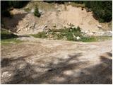
From the parking lot, take the cart track road, which branches off to the left of the road. Cart track goes into the wods and climbs moderately, crossing first a small and then a larger stream. Cart track, which has some shortcuts, makes a few bends and after a good 15 minutes leads to the pastures mountain pasture Lower Long Meadow.
After a short walk along mountain pasture, the path leads us to a crossroads where there are signposts. Bear right in the direction of the Koschutnikturm eastern approach route. After a few dozen steps, the gently sloping path leads to the shepherd's hut at mountain pasture Lower Dolga njiva.
Continue on the mountain pasture up the middle of which there is a wide dirt track which, after a good 15-minute walk, leads out of the forest to the mountain pasture Upper Long Meadow.
The steepness of the path, which has been moderate until now, eases and the path soon leads us through a beautiful grassy area to the central part of mountain pasture, where the markings end. Continue along the gently ascending path, which runs alongside a small but very distinct torrential gully. A little further on, the unmarked path splits into two parts.
Continue slightly to the right (Tolsta Košuta on the left) along the path which ascends a little further to the border ridge. Grebenc, a little further on, turns left, and the path first descends from the summit, and then leads us along and along the ridge to the top of Mala Košuta in a few minutes of scenic walking.
In the fog, orientation is difficult.
Starting point - Spodnja Dolga njiva 20 minutes, Spodnja Dolga njiva - Zgornja Dolga njiva 25 minutes, Zgornja Dolga njiva - Mala Košuta 30 minutes.

Pictures:
 1
1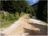 2
2 3
3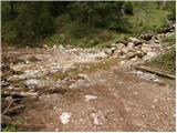 4
4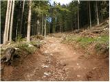 5
5 6
6 7
7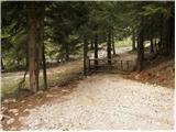 8
8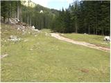 9
9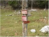 10
10 11
11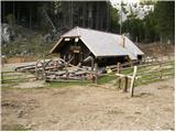 12
12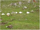 13
13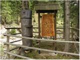 14
14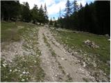 15
15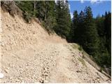 16
16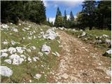 17
17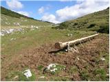 18
18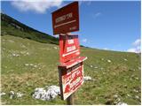 19
19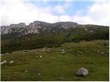 20
20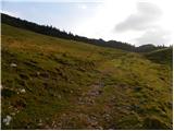 21
21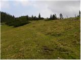 22
22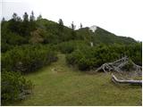 23
23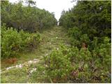 24
24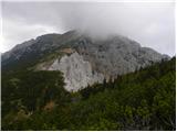 25
25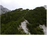 26
26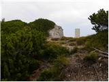 27
27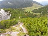 28
28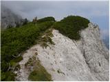 29
29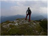 30
30
Discussion about the trail Pod Krnico - Mala Košuta
|
| Edina22. 09. 2009 |
Zelo lepa povezava s turo na Tolsto Košuto. Odkrila sem jo šele nazajgrede po predhodnem razgledovanju z obeh vrhov T. Košute. Na ta način se elegantno izognemo iskanju prehodov skozi ruševje. Lepo in razgledno, traja pa žal samo cca štiri ure. Kadar se odpravim na tako manj "atraktivno" in nemarkirano goro pa še med tednom, običajno srečam več živali kot ljudi, danes je bilo tam gori presenetljivo veliko obiskovalcev. Prijetno presenečena sem bila tudi nad planšarijo na D. Njivi. Razmere izpred nekaj let so se spremenile. Lepo. Vnesite tukaj
|
|
|
|
| Lunca28. 06. 2011 |
na planšariji v Dolgi njivi je ena izmed najbolj prijaznih "planšarc", Mateja! Vedno nasmejana in dobre volje... z lahkoto bi si jo kje drugje vzeli za zgled!
|
|
|
|
| robter27. 08. 2011 |
Če bi se rad na hitro naužil svežega zraka in razgledov na Košuto, KSA in hribovje okrog Jezerskega, je to zelo primeren izlet. Proti vrhu se je potrebno držati mejnega grebena, ker drugod rušje onemogoča prehod. Za trenutek se je danes celo pooblačilo, nato pa je veter razgnal oblake.
Masovnik na Dolgi njivi pa itak seka.
|
|
|
|
| tulipan18. 08. 2012 |
Mislim, da je Lidija ugotovila,
da opis velja za Meli Košuto.
|
|
|
|
| anazala3. 09. 2022 15:34:13 |
A ni to isto. Mala ali Meli. Sem bila. Meli je samo prestop na avstrijsko stran. V kolikor ni, prosim napišite. Vsaj vedela bom, kje sem sploh bila.
|
|
|
|
| anazala3. 09. 2022 15:34:28 |
A ni to isto. Mala ali Meli. Sem bila. Meli je samo prestop na avstrijsko stran. V kolikor ni, prosim napišite. Vsaj vedela bom, kje sem sploh bila.
|
|
|
|
| djimuzl4. 09. 2022 09:45:18 |
Ime Meli Košute se nanaša na značilen krušljiv predel na severni strani tega dela grebena Košute - pod Tolsto in Malo Košuto. Skozi tisti predel iz avstrijske strani vodi tudi geološka pot.
|
|
|
|
| turbo4. 09. 2022 11:10:20 |
|
|
|